Enviar búsqueda
Cargar
Management of the River Tees
•
1 recomendación
•
11,928 vistas
Bourne Grammar School
Seguir
Educación
Tecnología
Denunciar
Compartir
Denunciar
Compartir
1 de 4
Descargar ahora
Descargar para leer sin conexión
Recomendados
Flooding 7 River Tees Case Study
tudorgeog
Ventricular fibrillation eMedicine Article
Imhotep Virtual Medical School
9. hard and soft engineering
hfonfe
Acute pericarditis
Acute pericarditis
حسين عزالدين
Holderness case study
tonybattista
Coastal Case Studies
donotreply16
Coastal Processes on the Holderness Coast
Bourne Grammar School
Coasts igcse geography
Brittany Farrant
River Changes And Landforms
whiskeyhj
Ecg !
Ecg !
Pratik Kumar
Flood & Kosi
Flood & Kosi
Anandwardhana Dwivedi
GEOGRAPHY IGCSE: RIVER PROCESSES
George Dumitrache
Holderness good overview including detail
Will Williams
Lesson 14 the management of glacial landscapes
James Foster
Coastal Land Form
Coastal Land Form
Sudipta Roy
Coastal Management
Coastal Management
James Foster
Holderness Case Study
James Foster
CAMBRIDGE AS GEOGRAPHY REVISION: HYDROLOGY AND FLUVIAL GEOMORPHOLOGY - 1.3 RI...
George Dumitrache
CAMBRIDGE GEOGRAPHY AS - HYDROLOGY AND FLUVIAL GEOMORPHOLOGY; 1.1. DRAINAGE B...
George Dumitrache
Complications of MI and their managements
Dr. Mishal Saleem
L3.ap longshore drift and deposition
andypinks
GEOGRAPHY IGCSE: COASTAL PROCESSES
George Dumitrache
Module 3 cape unit 1 geography.
Oral Johnson
The Holderness Coastline
meganltaylor
CAMBRIDGE AS GEOGRAPHY - CASE STUDY: ABERFAN MUDFLOW
George Dumitrache
Sec 3 Coastal Management
chua.geog
L11 River Tees Case Study
tudorgeog
The Three Gorges Dam
Kella Randolph
River Tees From Source To Mouth
guest2a52f1
Flood Solutions – Soft Engineering Strategies
tudorgeog
Más contenido relacionado
La actualidad más candente
River Changes And Landforms
whiskeyhj
Ecg !
Ecg !
Pratik Kumar
Flood & Kosi
Flood & Kosi
Anandwardhana Dwivedi
GEOGRAPHY IGCSE: RIVER PROCESSES
George Dumitrache
Holderness good overview including detail
Will Williams
Lesson 14 the management of glacial landscapes
James Foster
Coastal Land Form
Coastal Land Form
Sudipta Roy
Coastal Management
Coastal Management
James Foster
Holderness Case Study
James Foster
CAMBRIDGE AS GEOGRAPHY REVISION: HYDROLOGY AND FLUVIAL GEOMORPHOLOGY - 1.3 RI...
George Dumitrache
CAMBRIDGE GEOGRAPHY AS - HYDROLOGY AND FLUVIAL GEOMORPHOLOGY; 1.1. DRAINAGE B...
George Dumitrache
Complications of MI and their managements
Dr. Mishal Saleem
L3.ap longshore drift and deposition
andypinks
GEOGRAPHY IGCSE: COASTAL PROCESSES
George Dumitrache
Module 3 cape unit 1 geography.
Oral Johnson
The Holderness Coastline
meganltaylor
CAMBRIDGE AS GEOGRAPHY - CASE STUDY: ABERFAN MUDFLOW
George Dumitrache
Sec 3 Coastal Management
chua.geog
L11 River Tees Case Study
tudorgeog
The Three Gorges Dam
Kella Randolph
La actualidad más candente
(20)
River Changes And Landforms
Ecg !
Ecg !
Flood & Kosi
Flood & Kosi
GEOGRAPHY IGCSE: RIVER PROCESSES
Holderness good overview including detail
Lesson 14 the management of glacial landscapes
Coastal Land Form
Coastal Land Form
Coastal Management
Coastal Management
Holderness Case Study
CAMBRIDGE AS GEOGRAPHY REVISION: HYDROLOGY AND FLUVIAL GEOMORPHOLOGY - 1.3 RI...
CAMBRIDGE GEOGRAPHY AS - HYDROLOGY AND FLUVIAL GEOMORPHOLOGY; 1.1. DRAINAGE B...
Complications of MI and their managements
L3.ap longshore drift and deposition
GEOGRAPHY IGCSE: COASTAL PROCESSES
Module 3 cape unit 1 geography.
The Holderness Coastline
CAMBRIDGE AS GEOGRAPHY - CASE STUDY: ABERFAN MUDFLOW
Sec 3 Coastal Management
L11 River Tees Case Study
The Three Gorges Dam
Destacado
River Tees From Source To Mouth
guest2a52f1
Flood Solutions – Soft Engineering Strategies
tudorgeog
River Tees (Geo Active 330)
S Rackley
Rivers Revision
Rivers Revision
Keith Phipps
Meeting powerpoint 2016
tudorgeog
L6 Causes Of Flooding
tudorgeog
Flooding 5 Bangladesh Gcse Aqa A
tudorgeog
Flooding 6 Solutions To Flooding
tudorgeog
COOL Geography rostows model (jas, wei, alex)
Tom McLean
IB Geography: Development: Rostow Model
Richard Allaway
Methods Of Flood Control
HNurton
Destacado
(11)
River Tees From Source To Mouth
Flood Solutions – Soft Engineering Strategies
River Tees (Geo Active 330)
Rivers Revision
Rivers Revision
Meeting powerpoint 2016
L6 Causes Of Flooding
Flooding 5 Bangladesh Gcse Aqa A
Flooding 6 Solutions To Flooding
COOL Geography rostows model (jas, wei, alex)
IB Geography: Development: Rostow Model
Methods Of Flood Control
Similar a Management of the River Tees
Rivers Year 11
Rivers Year 11
Keith Phipps
Group Rivers
Group Rivers
Keith Phipps
River mersey & kielder water
28tom
L12 Kielder Water Case Study
tudorgeog
CAMBRIDGE AS GEOGRAPHY - CASE STUDY: RIVER HARBOURNE
George Dumitrache
Uk Water Supply And Demand
tudorgeog
River Regulation - Biophysical Environments
Mr Shipp
Ppt.shivani
Ppt.shivani
Manisha Barua
Floodmanagementstrategies
Will Williams
Weather Hazards 2
Weather Hazards 2
total
Causes of flooding
Causes of flooding
aquinaspolitics
Rivers - George Mather, Chris Hancox, Alex Owen and Michael Soley
Keith Phipps
Lynmouth flooding
Lynmouth flooding
Nishay Patel
Dynamic planet revision 2015 qus
MrOH
Rivers
Rivers
PerrymanGeography
Flooding on the somerset levels
Noel Jenkins
Coasts Booklet
Coasts Booklet
missm
L11 Uk Water Supply And Demand
tudorgeog
Flood Somerset
Flood Somerset
GeoCoops
O. Litvina Floods
O. Litvina Floods
Nataliya Byzova
Similar a Management of the River Tees
(20)
Rivers Year 11
Rivers Year 11
Group Rivers
Group Rivers
River mersey & kielder water
L12 Kielder Water Case Study
CAMBRIDGE AS GEOGRAPHY - CASE STUDY: RIVER HARBOURNE
Uk Water Supply And Demand
River Regulation - Biophysical Environments
Ppt.shivani
Ppt.shivani
Floodmanagementstrategies
Weather Hazards 2
Weather Hazards 2
Causes of flooding
Causes of flooding
Rivers - George Mather, Chris Hancox, Alex Owen and Michael Soley
Lynmouth flooding
Lynmouth flooding
Dynamic planet revision 2015 qus
Rivers
Rivers
Flooding on the somerset levels
Coasts Booklet
Coasts Booklet
L11 Uk Water Supply And Demand
Flood Somerset
Flood Somerset
O. Litvina Floods
O. Litvina Floods
Más de Bourne Grammar School
River Tees
River Tees
Bourne Grammar School
What are periglacial processes?
Bourne Grammar School
What are fluvioglacial processes?
Bourne Grammar School
Glacial transportation and deposition
Bourne Grammar School
Representing place 2
Bourne Grammar School
Glacial erosion and weathering
Bourne Grammar School
What are ice ages?
What are ice ages?
Bourne Grammar School
What are glaciers?
What are glaciers?
Bourne Grammar School
Water aid in mali plan 2010 2015
Bourne Grammar School
East Cornwall CFMP
East Cornwall CFMP
Bourne Grammar School
Boscastle flood summary
Bourne Grammar School
Boscastle flood timeline
Bourne Grammar School
Boscastle flood North Cornwall Council
Bourne Grammar School
Climate Change: Effects on the UK
Bourne Grammar School
The Humber Estuary and Holderness Coast
Bourne Grammar School
Ate urban climatology
Bourne Grammar School
Urban heat island and air quality of london
Bourne Grammar School
Met Office - Microclimate
Bourne Grammar School
Más de Bourne Grammar School
(18)
River Tees
River Tees
What are periglacial processes?
What are fluvioglacial processes?
Glacial transportation and deposition
Representing place 2
Glacial erosion and weathering
What are ice ages?
What are ice ages?
What are glaciers?
What are glaciers?
Water aid in mali plan 2010 2015
East Cornwall CFMP
East Cornwall CFMP
Boscastle flood summary
Boscastle flood timeline
Boscastle flood North Cornwall Council
Climate Change: Effects on the UK
The Humber Estuary and Holderness Coast
Ate urban climatology
Urban heat island and air quality of london
Met Office - Microclimate
Último
Making communications land - Are they received and understood as intended? we...
Association for Project Management
How to Manage Global Discount in Odoo 17 POS
Celine George
ComPTIA Overview | Comptia Security+ Book SY0-701
bronxfugly43
How to Give a Domain for a Field in Odoo 17
Celine George
UGC NET Paper 1 Mathematical Reasoning & Aptitude.pdf
Nirmal Dwivedi
ICT role in 21st century education and it's challenges.
MaryamAhmad92
ICT Role in 21st Century Education & its Challenges.pptx
AreebaZafar22
Mehran University Newsletter Vol-X, Issue-I, 2024
Mehran University of Engineering & Technology, Jamshoro
Micro-Scholarship, What it is, How can it help me.pdf
Poh-Sun Goh
Asian American Pacific Islander Month DDSD 2024.pptx
David Douglas School District
General Principles of Intellectual Property: Concepts of Intellectual Proper...
Poonam Aher Patil
Magic bus Group work1and 2 (Team 3).pptx
dhanalakshmis0310
Russian Escort Service in Delhi 11k Hotel Foreigner Russian Call Girls in Delhi
kauryashika82
psychiatric nursing HISTORY COLLECTION .docx
PoojaSen20
Key note speaker Neum_Admir Softic_ENG.pdf
Admir Softic
Basic Civil Engineering first year Notes- Chapter 4 Building.pptx
Denish Jangid
Grant Readiness 101 TechSoup and Remy Consulting
TechSoup
Spellings Wk 3 English CAPS CARES Please Practise
AnaAcapella
1029 - Danh muc Sach Giao Khoa 10 . pdf
QucHHunhnh
Application orientated numerical on hev.ppt
RamjanShidvankar
Último
(20)
Making communications land - Are they received and understood as intended? we...
How to Manage Global Discount in Odoo 17 POS
ComPTIA Overview | Comptia Security+ Book SY0-701
How to Give a Domain for a Field in Odoo 17
UGC NET Paper 1 Mathematical Reasoning & Aptitude.pdf
ICT role in 21st century education and it's challenges.
ICT Role in 21st Century Education & its Challenges.pptx
Mehran University Newsletter Vol-X, Issue-I, 2024
Micro-Scholarship, What it is, How can it help me.pdf
Asian American Pacific Islander Month DDSD 2024.pptx
General Principles of Intellectual Property: Concepts of Intellectual Proper...
Magic bus Group work1and 2 (Team 3).pptx
Russian Escort Service in Delhi 11k Hotel Foreigner Russian Call Girls in Delhi
psychiatric nursing HISTORY COLLECTION .docx
Key note speaker Neum_Admir Softic_ENG.pdf
Basic Civil Engineering first year Notes- Chapter 4 Building.pptx
Grant Readiness 101 TechSoup and Remy Consulting
Spellings Wk 3 English CAPS CARES Please Practise
1029 - Danh muc Sach Giao Khoa 10 . pdf
Application orientated numerical on hev.ppt
Management of the River Tees
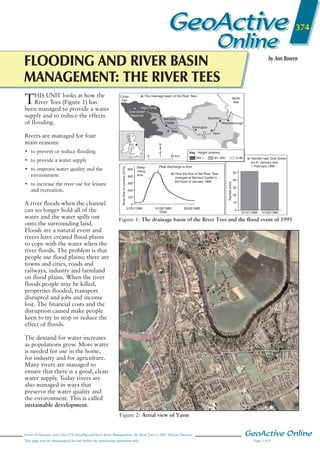
1.
GeoActive 374 Online FLOODING AND RIVER
BASIN MANAGEMENT: THE RIVER TEES T HIS UNIT looks at how the River Tees (Figure 1) has been managed to provide a water supply and to reduce the effects of flooding. by Ann Bowen a) The drainage basin of the River Tees Cross Fell High Force Cow Green Reservoir North Sea Stockton Barnard Castle Middlesbrough Darlington R. Tees Rivers are managed for four main reasons: Yarm N • to prevent or reduce flooding Key Height (metres) 20 km 301+ • to improve water quality and the environment • to increase the river use for leisure and recreation. A river floods when the channel can no longer hold all of the water and the water spills out onto the surrounding land. Floods are a natural event and rivers have created flood plains to cope with the water when the river floods. The problem is that people use flood plains; there are towns and cities, roads and railways, industry and farmland on flood plains. When the river floods people may be killed, properties flooded, transport disrupted and jobs and income lost. The financial costs and the disruption caused make people keen to try to stop or reduce the effect of floods. River flow in cumecs (m3/s) • to provide a water supply 500 400 Steep rising limb 300 0–60 c) Rainfall near Cow Green on 31 January and 1 February 1995 Peak discharge or flow b) How the flow in the River Tees changed at Barnard Castle in the flood of January 1995 200 100 0 31/01/1995 61–300 50 Rainfall (mm) 0 40 30 20 10 01/02/1995 Days 02/02/1995 0 31/01/1995 01/02/1995 Figure 1: The drainage basin of the River Tees and the flood event of 1995 GeoActive Series 18 Issue 3 Fig 374_01 Mac/eps/illustrator 11 s/s NELSON THORNES PUBLISHING Artist: David Russell Illustration The demand for water increases as populations grow. More water is needed for use in the home, for industry and for agriculture. Many rivers are managed to ensure that there is a good, clean water supply. Today rivers are also managed in ways that preserve the water quality and the environment. This is called sustainable development. Figure 2: Aerial view of Yarm Series 18 Summer issue Unit 374 Flooding and River Basin Management: the River Tees © 2007 Nelson Thornes This page may be photocopied for use within the purchasing institution only. GeoActive Online Page 1 of 4
2.
Why does the
River Tees need to be managed? A flashy river The River Tees rises on the slopes of Cross Fell at a height of 893 metres. The area receives over 2,000 millimetres of rain each year. The rainfall reaches the river quickly because the slopes are steep and very little water can infiltrate due to the impermeable rocks and saturated peat. After heavy rainfall or when the snow melts in the spring the river level can rise quickly and the water also flows downstream quickly. This can cause the ‘Tees roll’ or ‘Tees wave’, when the river level may rise as much as a metre in 15 minutes. There is a long history of flooding along the River Tees, especially in its lower course. Figure 2 shows the town of Yarm. A densely populated area In the lower course of the river there are towns such as Yarm, Stockton and Middlesbrough. The area is densely populated and there are also large industrial areas such as the ICI chemical works. Flood damage can run into hundreds of thousands of pounds. There is also a huge demand for water for use in homes, industry and agriculture. The long history of heavy industry in the region had caused water pollution and the loss of salmon and trout in the river. Managing the River Tees In the upper Tees basin There are nine reservoirs in the River Tees drainage basin (Figure 3). The largest is Cow Green Reservoir, completed in 1971, which can hold 41 million cubic metres of water. The reservoirs store water which can then be released in times of low flow to cope with the increasing water needs of homes, industry and agriculture further downstream. The reservoirs are also used to store large quantities of water at times of heavy rainfall or snowmelt to reduce the peak flow and so help to prevent flooding. GeoActive Online Page 2 of 4 Reservoir Hurworth Burn Lockwood Hury Blackton Crookfoot Grassholme Selset Balderhead Cow Green Year of completion Capacity (million m3) 1871 1877 1894 1896 1903 1915 1960 1965 1971 0.7 0.5 3.9 2.1 1.1 6.1 15.3 19.7 40.9 Catchment area (km2) 13.9 – 43.1 43.1 5.4 78.7 78.7 43.1 58.9 Figure 3: Reservoirs in the Tees valley Area most likely to flood Area least likely to flood Metres above sea level 30 20 10 0 Key River Grazing land only Settlement Crops and grazing Road Figure 4: Flood plain zoning • building of the Tees barrage to In recent years new GeoActive Series 18 Issue 3 the reduce developments of housing or Mac/eps/illustrator 11 s/s risk of flooding by the Fig 374_04 river and the sea industry have been discouraged NELSON THORNES PUBLISHING Artist: David Illustration in low-lying areas to reduce the Russell • dredging the river bed to increase likelihood of flooding of the channel size and improve navigation properties and to allow the flood plain to act naturally if a flood • new sewerage works and strict laws occurs. on dumping and industrial discharges to improve water quality. In the lower Tees basin The land here may suffer flooding from the river but also from storms and high tides in the North Sea. Some strategies aim to prevent flooding while others aim to reduce the impact of a flood should it occur. These include: • improved flood warning systems • new developments being refused planning permission in low-lying areas • monitoring of river and sea defences From 1810 the river was straightened by cutting through meanders. The first of these was the Mandale loop which shortened the river by 4 km. The flood water is therefore able to flow more quickly out to sea. The introduction of flood plain zoning (Figure 4) allows the river to flood naturally and reduces the need for flood defences, which are expensive and do not always last very long. The Tees Series 18 Summer issue Unit 374 Flooding and River Basin Management: the River Tees © 2007 Nelson Thornes This page may be photocopied for use within the purchasing institution only.
3.
Key 1 Caravan and
camping park 2 Restaurant/pub/Travel Inn 3 North car park 4 West car park 5 White Water Centre/shop/ restaurant 6 Warm-up lake 7 Navigation lock 8 Tees barage 9 Fish pass 10 White water course 1 2 3 10 4 5 6 River Tees 9 8 7 A66 to Middlesbrough A66 to Stockton, Darlington, Teesside Airport Teesside Retail & Leisure Park Figure 5: The Tees barrage with concrete walls covered with stone. The walls have flood gates in them to allow access by people and vehicles. A new landscaped earth embankment has been built to protect Yarm school. Gabions (rocks in wire cages) have also been put in place to reduce erosion along embankments. Pipes have been laid to redirect the flow of a tributary, the Skyterring Beck. To improve the environment, street lighting, flower beds, street furniture and fishing platforms have been developed. The Yarm flood defence system Yarm is a market town on the River Tees with a long history of serious flooding. The earliest recorded flood was in 1575. The town has suffered a lot of damage due to flooding over the years. A new defence scheme has been built to cope with an extreme flood, one that may only happen every 100 years, and to improve the riverside environment. The scheme was only finalised after extensive consultation with many local people and environmental groups. The defences have cost £2.1 million. The town is built around a large meander on the River Tees (see Figure 2). Parts of the river have been reinforced The River Tees has seen a range of management strategies, from hard engineering such as the reservoirs and the Tees barrage, to softer management strategies including tree planting and flood plain zoning. Some of the strategies aim to stop floods happening while others aim to reduce the effects of floods when they occur. The reservoirs also ensure there is a large water supply for the people who live and work in the Tees valley. In recent years new developments have improved the water quality and the environment and encouraged more recreational use of the Tees valley. The Tees barrage GeoActive Series 18 Issue 3 barrage 374_05 Mac/eps/illustrator 11 The barrage was officially opened Fig (Figure 5) has been s/s in designed to preserve the PUBLISHING 1995 by HRH The Duke of NELSON THORNES environment, David Russellby not Artist: for example IllustrationEdinburgh. The barrage (Figure 5) damaging the unique ecosystem in the estuary and including salmon leaps so that the fish can migrate upstream for breeding. Seal Sands at the mouth of the estuary is a world-famous site for seals and migratory birds. Recent river management schemes have made sure that the area is not damaged. Conclusion stops the tidal flows upstream and has opened up 25 km of clean navigable waterway for leisure. It has led to the regeneration of derelict land along the riverside and attracted new jobs and businesses to Teesside. The barrage cost £54 million and links the north and south banks of the Tees at Stockton. It includes a lock that allows boats to pass through as well as a fish pass, a road bridge and Britain’s finest white-water course. Salmon have now returned to the River Tees. The barrage is 70 metres wide and 32 metres long. Between the barrage supports are four gates, each weighing 50 tonnes and measuring 13.5 metres long and 8 metres high. These regulate the flow of river water and also act as a barrier to prevent tidal flooding moving upstream. Around the barrage are car parks, a camping and caravan site, restaurants, shops and woodland planting of 100,000 trees and shrubs. Series 18 Summer issue Unit 374 Flooding and River Basin Management: the River Tees © 2007 Nelson Thornes This page may be photocopied for use within the purchasing institution only. Glossary Dredging – deepening the river channel by removing sand and silt. Ecosystem – the combination of plants and animals in an environment with certain soils and climate. Estuary – the drowned river mouth in a lowland area. Flood – when river water leaves its channel. Flood plain – the flat area of land on either side of a river in its lower course. Flood plain zoning – restricting the use of land close to a river to reduce the impact of a flood, for example grazing land nearest the river and settlement further away. Gabions – rocks set in wire cages to reduce erosion. Impermeable – does not allow water to pass through. Infiltration – the rate at which water may pass through soil or rocks. Meander – a bend in the river. Peak flow – the maximum flow of a river during a rainstorm. Reservoir – an artificial lake built to store water. River basin – the area of land drained by a river. Runoff – the amount of water that reaches a river. Sustainable development – new developments that do not destroy the environment but may improve it. GeoActive Online Page 3 of 4
4.
Activities 1 Give four
reasons why rivers may be managed. 2 (a) Look at Figure 6. Add these labels in the correct places on the map to show why the River Tees floods: • Rainfall over 2,000 mm • Steep slopes • Heavily built-up and populated flood plain • Impermeable rocks (c) True of false? Which of the following statements may explain the change that has occurred? (i) A larger water supply was needed as the towns and industries grew on Teesside. (ii) The amount of rainfall increased. (iii) New technology allowed larger reservoirs to be built. (iv) There was more demand for flood protection. (v) People wanted more reservoirs for fishing and yachting. 6 Discussion In small groups, discuss the different strategies of river basin management used along the River Tees. Each group might like to consider just one of these schemes: • reservoirs • embankments with gabions • the Tees barrage • meander cut-offs • flood plain zoning • flood warning systems • dredging. • Threat of flooding from the sea (b) Why is the River Tees called a ‘flashy’ river? • the Lower Tees 3 (a) Using the information in Figure 7, draw a graph to show rainfall and runoff for the River Tees. (b) What is runoff? (c) In which season is runoff the greatest? (d) Describe the link between rainfall and runoff. (e) Suggest why the gap between rainfall and runoff changes during the year. In your groups consider the following questions: (a) Is the technique an example of hard or soft engineering? (b) What are the advantages of the strategy? (c) What are the disadvantages of the strategy? (d) If further management was needed in the Tees valley, would it be a good strategy for the future? (e) Overall, how many marks out of 10 would you give it? Record your thoughts on a piece of A3 paper and contribute your ideas to a class discussion. 5 Choose one of the following: • the Tees barrage. 4 Study Figure 3. (a) Complete a graph to show the capacity of the reservoirs and the year in which they were built. (b) What has happened to the size of the reservoirs over time? • the Yarm flood defence scheme Produce a flyer informing the local residents about the scheme. You should include the following: • Title • Reasons for / aims of the scheme • What the scheme involves • Some photos/diagrams of the scheme – search the internet. J F M A M J J A Rainfall (mm) 181 120 143 92 92 88 94 116 Runoff (mm) 151 108 129 89 64 55 58 68 S O N D 129 146 167 184 73 97 119 151 Figure 7: Average rainfall and runoff for the River Tees N Cross Fell North Sea High Force Cow Green Reservoir Stockton Barnard Castle Middlesbrough Darlington R. Tees 0 20 km Yarm Key Height (metres) 301+ 61–300 0–60 Figure 6: The drainage basin of the River Tees GeoActive Online Page 4 of 4 Series 18 Summer issue Unit 374 Flooding and River Basin Management: the River Tees © 2007 Nelson Thornes This 3 GeoActive Series 18 Issue page may be photocopied for use within the purchasing institution only. Fig 374_06 Mac/eps/illustrator 11 s/s NELSON THORNES PUBLISHING
Descargar ahora