SlideShare una empresa de Scribd logo
1 de 4
Descargar para leer sin conexión
Versatile GNSS Solution
with Exceptional Post-Processing
ProMark™
120
Add logo (EPS format preferred for best results)
ProMark 120
The Spectra Precision ProMark™
120
GNSS system is the most versatile
post-processing solution, designed
for easy and efficient land survey
applications. Thanks to the embedded
Ashtech Z-Blade technology as well as
GPS and GLONASS signals tracking,
ProMark 120 provides high-precision
measurements even in very demanding
or obstructed environments.
The very intuitive ProMark Field software
is designed for simple and trouble-free
use. It provides all the tools you need,
without any unnecessary or complicated
features. Its lightweight, but rugged and
waterproof handheld design, all-day-long
autonomy, and large memory make
ProMark 120 the perfect solution for
easy and efficient surveying.
Designed as a scalable solution,
ProMark 120 can be easily upgraded
to such capabilities as GLONASS,
RTK or GPRS and be used not only
in post-processing but also in RTK or
GIS applications. Built on the state-of
the-art Windows Embedded Handheld
6.5 platform with integrated wireless
communications, ProMark 120 is a
truly versatile and complete offering.
Outstanding GPS &
GLONASS Performance
■■ Ashtech Z-Blade GNSS centric
signal processing
■■ Short occupation time
■■ Extended productivity in
obstructed conditions
Unparalled Ease-Of-Use
■■ Intuitive ProMark Field software
■■ Lightweight and rugged
handheld design
■■ All-day-long operations with
extended memory and battery
Versatile Solution
■■ Extended survey scalability: RTK,
GLONASS, GIS options
■■ State-of-the-art Windows Embedded
Handheld 6.5 open platform
■■ Complete wireless communications
ProMark120
ProMark Field Software
Easy-to-use and very intuitive, ProMark Field software is designed
for simple and trouble-free use of the ProMark 120. It provides
all necessary tools for efficient post-processing survey as well as
simple RTK jobs, including raw data recording, rover and base
configurations, static or kinematic surveys, network connection
settings, or stake out. ProMark Field software brings to ProMark
120 users a simple but powerful tool, without any unnecessary or
complicated features.
Spectra Precision Survey Office Software
Spectra Precision Survey Office software is ideal for processing
and analyzing GNSS survey data recorded in the field. With Spectra
Precision Survey Office software you have the ability to work with RTK
and Static/PPK data to generate reports as well as identify and correct
field errors. The intuitive, integrated Spectra Precision Survey Office
program saves time with its short learning curve and powerful features.
Add logo (EPS format preferred for best results)
Contact Information:
COMPANY NAME HERE
Trimble Spectra Precision Division
1234 State Street • City, State 95014 • USA
Toll Free +1-555-555-5555 • Fax +1-555-555-5555
www.yourwebsite.com
Add your
company
info here
GNSS Characteristics
■■ 45 parallel all-in-view channels
-	 GPS L1 C/A, L1 P-code, full
wavelength carrier
-	 GLONASS L1 C/A, full wavelength carrier
-	 SBAS: WAAS/EGNOS/MSAS
■■ Fully independent code and phase
measurements
■■ Advanced multipath mitigation
■■ Ashtech Z-Blade technology for optimal
performance
■■ Up to 20 Hz real-time GPS, GLONASS, SBAS
raw data (code and carrier) and position
output
■■ Supported data formats: ATOM (Ashtech
Optimized Messaging), RTCM-2.3, RTCM-3.1,
CMR, CMR+, DBEN, LRK
■■ NMEA 0183 messages output
■■ RTK Network: VRS, FKP, MAC
Accuracy Specifications (HRMS) 1 2 3
■■ Static post-processing: 5 mm + 1 ppm typical
■■ Kinematic post-processing: 12 mm + 2 ppm
typical
■■ RTK: 10 mm + 1 ppm typical
■■ DGPS: < 30 cm + 1 ppm typical
■■ SBAS: < 50 cm
RTK Initialization (on-the-fly)
Initialization time
■■ < 3 min typical (GPS + GLONASS)
■■ < 5 min typical (GPS only)
Range
■■ Up to 10 km typical, GPS + GLONASS
■■ Up to 7 km typical, GPS only
Reliability
■■ Up to 99.9% typical
Processor
■■ Marvell®
PXA 320
■■ Clock frequency: 806 MHz
Operating System
■■ Microsoft Windows®
Embedded Handheld 6.5
■■ Languages available: English, French,
German, Greek, Italian, Japanese, Korean,
Portuguese, Spanish, Chinese
■■ Software package includes:
-	 GNSS Toolbox for GNSS control
-	 Internet Explorer
-	 E-mail client
-	 Microsoft Office Mobile
-	 Transcriber (handwriting recognition)
-	 ActiveSync
Communication
Cellular
■■ Built-in GPRS, EDGE class 12
modem Cinterion MC 75i
■■ Quad-band 850/900MHz, 1800/1900 MHz
Bluetooth
■■ Bluetooth 2.1 (class 2) with DER
■■ Profiles: SPP, DUN, FTP, OPP, HSP, A2DP
Other
■■ Wireless LAN 802.11b/g (SDIO slot)
Physical Characteristics
Size
■■ Receiver: 190x90x43 mm (7.5x3.5x1.7 in)
Weight
■■ Receiver only: 0.48 kg (1.06 lb)
■■ Receiver with battery: 0.62 kg (1.43 lb)
User Interface
Keyboard
■■ Alphanumeric virtual keyboard
■■ 4-way navigation, OK, menu, escape, zoom
in/out, contextual keys
Display
■■ Color TFT High resolution sunlight readable
display with touch screen
■■ Size: 3.5” portrait
Memory
■■ SDRAM: 256 MB
■■ User data storage: 2 GB NAND Flash (non
volatile)
■■ SDHC memory card slot
Environmental Characteristics
■■ Operating temperature: -20° to +60°C
(-4 to 140°F)
■■ Storage temperature: -25° to +70°C
(-13 to 158°F)
■■ Humidity: 90%
■■ Waterproof
■■ Vibration and Shock: ETS300 019, MIL-
STD-810 method 514.5
■■ Free pole drop
Power Characteristics
■■ Removable battery: Li-Ion, 6600mAh
■■ Battery life: > 8 hrs @ 20 °C with GNSS on 4
■■ Charging time: 3 hours
■■ External power: 9-28 VDC
Multimedia & Sensors
■■ Camera 3M pixels
■■ E-Compass
■■ G-Sensor
■■ Microphone & Speaker
Software / Firmware Options
Firmware options
■■ GLONASS
■■ RTK
■■ GSM/GPRS Modem
■■ GNSS L2 5
■■ Fast Output
Software options
■■ Spectra Precision Survey Office software
Standard Accessories
■■ Integrated stylus
■■ Docking station
-	 Unit charging
-	 RS232 Interface
-	 USB Host and Device
-	 Additional battery charging slot
■■ Universal A/C adapter
■■ USB data cable
■■ ASH-660, L1 GPS/GLONASS antenna
■■ Field bracket
■■ Antenna vertical extension
■■ HI tape
■■ Field soft bag
Optional Accessories
■■ ASH-661, L1/L2 GNSS antenna 5
(*)
Including all available options
(1)
Accuracy and initialization specifications may be affected by
atmospheric conditions, signal multipath, satellite geometry and
corrections availability and quality. Position accuracy specifications
are for horizontal positioning. Vertical error is typically < 2 times
horizontal error.
(2)
Performance values assume a minimum of five satellites and
following the procedures recommended in the product manual.
High multipath areas, high PDOP values and periods of sever
atmospheric conditions may degrade performance.
(3)
Steady state value for baselines < 50 km after sufficient
convergence time.
(4)
No BT or WLAN are used, backlight at default setting (50%
brightness), varies with temperature.
(5)
Optional upgrade to ProMark 220.
SCAN THIS
CODE FOR MORE
INFORMATION
To locate your nearest distributor, visit www.spectraprecision.com. Specifications and descriptions are subject to change without notice.
Please visit www.spectraprecision.com for the latest product information.
©2012 Trimble Navigation Limited. All rights reserved. Spectra Precision is a Division of Trimble Navigation Limited. Spectra Precision and the Spectra Precision logo are trademarks
of Trimble Navigation Limited or its subsidiaries. Ashtech, the Ashtech logo, Z-Blade and ProMark are trademarks of Ashtech S.A.S. or its subsidiaries. All other trademarks are the
property of their respective owners. (09/28) PN 022487-180
ProMark 120 Technical Specifications*

Más contenido relacionado

Más de Budi anto

Brosur spectra Call 082119953499
Brosur spectra Call 082119953499Brosur spectra Call 082119953499
Brosur spectra Call 082119953499
Budi anto
 
Ready Base Station Spectra Pro flex 800cors Call 08211
Ready Base Station Spectra Pro flex 800cors Call 08211Ready Base Station Spectra Pro flex 800cors Call 08211
Ready Base Station Spectra Pro flex 800cors Call 08211
Budi anto
 

Más de Budi anto (20)

Jual Waterpas Leica NA300 Series
Jual Waterpas Leica NA300 SeriesJual Waterpas Leica NA300 Series
Jual Waterpas Leica NA300 Series
 
Jual Digital Level Leica Sprinter 150M
Jual Digital Level Leica Sprinter 150MJual Digital Level Leica Sprinter 150M
Jual Digital Level Leica Sprinter 150M
 
Jual Theodolite Sokkia
Jual Theodolite Sokkia Jual Theodolite Sokkia
Jual Theodolite Sokkia
 
Jual Leica ULTRA DS Utility Tracing System
Jual Leica ULTRA DS Utility Tracing SystemJual Leica ULTRA DS Utility Tracing System
Jual Leica ULTRA DS Utility Tracing System
 
Jual ECHO SOUNDER D270
Jual ECHO SOUNDER D270 Jual ECHO SOUNDER D270
Jual ECHO SOUNDER D270
 
Jual CHCNAV P330 PRO UAV VTOL
Jual CHCNAV P330 PRO UAV VTOL Jual CHCNAV P330 PRO UAV VTOL
Jual CHCNAV P330 PRO UAV VTOL
 
Jual CHCNAV UAV BB4 dengan rancangan khusus untuk pekerjaan survey profesional
Jual CHCNAV UAV BB4 dengan rancangan khusus untuk pekerjaan survey profesional Jual CHCNAV UAV BB4 dengan rancangan khusus untuk pekerjaan survey profesional
Jual CHCNAV UAV BB4 dengan rancangan khusus untuk pekerjaan survey profesional
 
APACHE 4 AUTONOMOUS HYDROGRAPHIC SURVEY USV CALL/ WA 082119953499
APACHE 4 AUTONOMOUS HYDROGRAPHIC SURVEY USV CALL/ WA 082119953499APACHE 4 AUTONOMOUS HYDROGRAPHIC SURVEY USV CALL/ WA 082119953499
APACHE 4 AUTONOMOUS HYDROGRAPHIC SURVEY USV CALL/ WA 082119953499
 
Jual GPS Spectra SP20 Call / wa 082119953499
Jual GPS Spectra SP20 Call / wa 082119953499Jual GPS Spectra SP20 Call / wa 082119953499
Jual GPS Spectra SP20 Call / wa 082119953499
 
Jual Waterpas Sokkia B20, B30, B40 Call/ wa : 082119953499
Jual Waterpas Sokkia B20, B30, B40 Call/ wa : 082119953499Jual Waterpas Sokkia B20, B30, B40 Call/ wa : 082119953499
Jual Waterpas Sokkia B20, B30, B40 Call/ wa : 082119953499
 
Jual Total Station Sokkia IM-105 Call 082119953499
Jual Total Station Sokkia IM-105 Call 082119953499Jual Total Station Sokkia IM-105 Call 082119953499
Jual Total Station Sokkia IM-105 Call 082119953499
 
Jasa Kalibrasi, Rental dan Jual Total Station Sokkia IM-52 Call/ wa 082119953499
Jasa Kalibrasi, Rental dan Jual Total Station Sokkia IM-52 Call/ wa 082119953499Jasa Kalibrasi, Rental dan Jual Total Station Sokkia IM-52 Call/ wa 082119953499
Jasa Kalibrasi, Rental dan Jual Total Station Sokkia IM-52 Call/ wa 082119953499
 
Jasa Kalibrasi, Rental dan Jual Total Station Topcon GM-105 Call 082119953499
Jasa Kalibrasi, Rental dan Jual Total Station Topcon GM-105 Call 082119953499Jasa Kalibrasi, Rental dan Jual Total Station Topcon GM-105 Call 082119953499
Jasa Kalibrasi, Rental dan Jual Total Station Topcon GM-105 Call 082119953499
 
Jual Total Station Topcon GM-100 Series Call 082119953499
Jual Total Station Topcon GM-100 Series Call 082119953499Jual Total Station Topcon GM-100 Series Call 082119953499
Jual Total Station Topcon GM-100 Series Call 082119953499
 
Jual GPS Spectra SP20 Call / wa 082119953499
Jual GPS Spectra SP20 Call / wa 082119953499Jual GPS Spectra SP20 Call / wa 082119953499
Jual GPS Spectra SP20 Call / wa 082119953499
 
Brosur spectra Call 082119953499
Brosur spectra Call 082119953499Brosur spectra Call 082119953499
Brosur spectra Call 082119953499
 
Ready Base Station Spectra Pro flex 800cors Call 08211
Ready Base Station Spectra Pro flex 800cors Call 08211Ready Base Station Spectra Pro flex 800cors Call 08211
Ready Base Station Spectra Pro flex 800cors Call 08211
 
Water
WaterWater
Water
 
Sp80
Sp80Sp80
Sp80
 
Sp80 GNSS Receiver
Sp80 GNSS ReceiverSp80 GNSS Receiver
Sp80 GNSS Receiver
 

Último

Artificial Intelligence: Facts and Myths
Artificial Intelligence: Facts and MythsArtificial Intelligence: Facts and Myths
Artificial Intelligence: Facts and Myths
Joaquim Jorge
 

Último (20)

How to Troubleshoot Apps for the Modern Connected Worker
How to Troubleshoot Apps for the Modern Connected WorkerHow to Troubleshoot Apps for the Modern Connected Worker
How to Troubleshoot Apps for the Modern Connected Worker
 
Boost PC performance: How more available memory can improve productivity
Boost PC performance: How more available memory can improve productivityBoost PC performance: How more available memory can improve productivity
Boost PC performance: How more available memory can improve productivity
 
TrustArc Webinar - Stay Ahead of US State Data Privacy Law Developments
TrustArc Webinar - Stay Ahead of US State Data Privacy Law DevelopmentsTrustArc Webinar - Stay Ahead of US State Data Privacy Law Developments
TrustArc Webinar - Stay Ahead of US State Data Privacy Law Developments
 
Data Cloud, More than a CDP by Matt Robison
Data Cloud, More than a CDP by Matt RobisonData Cloud, More than a CDP by Matt Robison
Data Cloud, More than a CDP by Matt Robison
 
Real Time Object Detection Using Open CV
Real Time Object Detection Using Open CVReal Time Object Detection Using Open CV
Real Time Object Detection Using Open CV
 
Apidays New York 2024 - The value of a flexible API Management solution for O...
Apidays New York 2024 - The value of a flexible API Management solution for O...Apidays New York 2024 - The value of a flexible API Management solution for O...
Apidays New York 2024 - The value of a flexible API Management solution for O...
 
Bajaj Allianz Life Insurance Company - Insurer Innovation Award 2024
Bajaj Allianz Life Insurance Company - Insurer Innovation Award 2024Bajaj Allianz Life Insurance Company - Insurer Innovation Award 2024
Bajaj Allianz Life Insurance Company - Insurer Innovation Award 2024
 
Repurposing LNG terminals for Hydrogen Ammonia: Feasibility and Cost Saving
Repurposing LNG terminals for Hydrogen Ammonia: Feasibility and Cost SavingRepurposing LNG terminals for Hydrogen Ammonia: Feasibility and Cost Saving
Repurposing LNG terminals for Hydrogen Ammonia: Feasibility and Cost Saving
 
A Year of the Servo Reboot: Where Are We Now?
A Year of the Servo Reboot: Where Are We Now?A Year of the Servo Reboot: Where Are We Now?
A Year of the Servo Reboot: Where Are We Now?
 
ProductAnonymous-April2024-WinProductDiscovery-MelissaKlemke
ProductAnonymous-April2024-WinProductDiscovery-MelissaKlemkeProductAnonymous-April2024-WinProductDiscovery-MelissaKlemke
ProductAnonymous-April2024-WinProductDiscovery-MelissaKlemke
 
TrustArc Webinar - Unlock the Power of AI-Driven Data Discovery
TrustArc Webinar - Unlock the Power of AI-Driven Data DiscoveryTrustArc Webinar - Unlock the Power of AI-Driven Data Discovery
TrustArc Webinar - Unlock the Power of AI-Driven Data Discovery
 
Axa Assurance Maroc - Insurer Innovation Award 2024
Axa Assurance Maroc - Insurer Innovation Award 2024Axa Assurance Maroc - Insurer Innovation Award 2024
Axa Assurance Maroc - Insurer Innovation Award 2024
 
Deploy with confidence: VMware Cloud Foundation 5.1 on next gen Dell PowerEdg...
Deploy with confidence: VMware Cloud Foundation 5.1 on next gen Dell PowerEdg...Deploy with confidence: VMware Cloud Foundation 5.1 on next gen Dell PowerEdg...
Deploy with confidence: VMware Cloud Foundation 5.1 on next gen Dell PowerEdg...
 
Automating Google Workspace (GWS) & more with Apps Script
Automating Google Workspace (GWS) & more with Apps ScriptAutomating Google Workspace (GWS) & more with Apps Script
Automating Google Workspace (GWS) & more with Apps Script
 
Strategize a Smooth Tenant-to-tenant Migration and Copilot Takeoff
Strategize a Smooth Tenant-to-tenant Migration and Copilot TakeoffStrategize a Smooth Tenant-to-tenant Migration and Copilot Takeoff
Strategize a Smooth Tenant-to-tenant Migration and Copilot Takeoff
 
Mastering MySQL Database Architecture: Deep Dive into MySQL Shell and MySQL R...
Mastering MySQL Database Architecture: Deep Dive into MySQL Shell and MySQL R...Mastering MySQL Database Architecture: Deep Dive into MySQL Shell and MySQL R...
Mastering MySQL Database Architecture: Deep Dive into MySQL Shell and MySQL R...
 
MINDCTI Revenue Release Quarter One 2024
MINDCTI Revenue Release Quarter One 2024MINDCTI Revenue Release Quarter One 2024
MINDCTI Revenue Release Quarter One 2024
 
Artificial Intelligence: Facts and Myths
Artificial Intelligence: Facts and MythsArtificial Intelligence: Facts and Myths
Artificial Intelligence: Facts and Myths
 
Manulife - Insurer Innovation Award 2024
Manulife - Insurer Innovation Award 2024Manulife - Insurer Innovation Award 2024
Manulife - Insurer Innovation Award 2024
 
Connector Corner: Accelerate revenue generation using UiPath API-centric busi...
Connector Corner: Accelerate revenue generation using UiPath API-centric busi...Connector Corner: Accelerate revenue generation using UiPath API-centric busi...
Connector Corner: Accelerate revenue generation using UiPath API-centric busi...
 

Jual GPS Geodetic Spectra Promark 120 L1 Glonas Call 082119953499

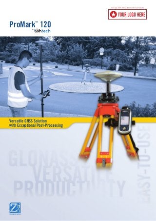
  • 1. Versatile GNSS Solution with Exceptional Post-Processing ProMark™ 120 Add logo (EPS format preferred for best results)
  • 2. ProMark 120 The Spectra Precision ProMark™ 120 GNSS system is the most versatile post-processing solution, designed for easy and efficient land survey applications. Thanks to the embedded Ashtech Z-Blade technology as well as GPS and GLONASS signals tracking, ProMark 120 provides high-precision measurements even in very demanding or obstructed environments. The very intuitive ProMark Field software is designed for simple and trouble-free use. It provides all the tools you need, without any unnecessary or complicated features. Its lightweight, but rugged and waterproof handheld design, all-day-long autonomy, and large memory make ProMark 120 the perfect solution for easy and efficient surveying. Designed as a scalable solution, ProMark 120 can be easily upgraded to such capabilities as GLONASS, RTK or GPRS and be used not only in post-processing but also in RTK or GIS applications. Built on the state-of the-art Windows Embedded Handheld 6.5 platform with integrated wireless communications, ProMark 120 is a truly versatile and complete offering. Outstanding GPS & GLONASS Performance ■■ Ashtech Z-Blade GNSS centric signal processing ■■ Short occupation time ■■ Extended productivity in obstructed conditions Unparalled Ease-Of-Use ■■ Intuitive ProMark Field software ■■ Lightweight and rugged handheld design ■■ All-day-long operations with extended memory and battery Versatile Solution ■■ Extended survey scalability: RTK, GLONASS, GIS options ■■ State-of-the-art Windows Embedded Handheld 6.5 open platform ■■ Complete wireless communications ProMark120
  • 3. ProMark Field Software Easy-to-use and very intuitive, ProMark Field software is designed for simple and trouble-free use of the ProMark 120. It provides all necessary tools for efficient post-processing survey as well as simple RTK jobs, including raw data recording, rover and base configurations, static or kinematic surveys, network connection settings, or stake out. ProMark Field software brings to ProMark 120 users a simple but powerful tool, without any unnecessary or complicated features. Spectra Precision Survey Office Software Spectra Precision Survey Office software is ideal for processing and analyzing GNSS survey data recorded in the field. With Spectra Precision Survey Office software you have the ability to work with RTK and Static/PPK data to generate reports as well as identify and correct field errors. The intuitive, integrated Spectra Precision Survey Office program saves time with its short learning curve and powerful features.
  • 4. Add logo (EPS format preferred for best results) Contact Information: COMPANY NAME HERE Trimble Spectra Precision Division 1234 State Street • City, State 95014 • USA Toll Free +1-555-555-5555 • Fax +1-555-555-5555 www.yourwebsite.com Add your company info here GNSS Characteristics ■■ 45 parallel all-in-view channels - GPS L1 C/A, L1 P-code, full wavelength carrier - GLONASS L1 C/A, full wavelength carrier - SBAS: WAAS/EGNOS/MSAS ■■ Fully independent code and phase measurements ■■ Advanced multipath mitigation ■■ Ashtech Z-Blade technology for optimal performance ■■ Up to 20 Hz real-time GPS, GLONASS, SBAS raw data (code and carrier) and position output ■■ Supported data formats: ATOM (Ashtech Optimized Messaging), RTCM-2.3, RTCM-3.1, CMR, CMR+, DBEN, LRK ■■ NMEA 0183 messages output ■■ RTK Network: VRS, FKP, MAC Accuracy Specifications (HRMS) 1 2 3 ■■ Static post-processing: 5 mm + 1 ppm typical ■■ Kinematic post-processing: 12 mm + 2 ppm typical ■■ RTK: 10 mm + 1 ppm typical ■■ DGPS: < 30 cm + 1 ppm typical ■■ SBAS: < 50 cm RTK Initialization (on-the-fly) Initialization time ■■ < 3 min typical (GPS + GLONASS) ■■ < 5 min typical (GPS only) Range ■■ Up to 10 km typical, GPS + GLONASS ■■ Up to 7 km typical, GPS only Reliability ■■ Up to 99.9% typical Processor ■■ Marvell® PXA 320 ■■ Clock frequency: 806 MHz Operating System ■■ Microsoft Windows® Embedded Handheld 6.5 ■■ Languages available: English, French, German, Greek, Italian, Japanese, Korean, Portuguese, Spanish, Chinese ■■ Software package includes: - GNSS Toolbox for GNSS control - Internet Explorer - E-mail client - Microsoft Office Mobile - Transcriber (handwriting recognition) - ActiveSync Communication Cellular ■■ Built-in GPRS, EDGE class 12 modem Cinterion MC 75i ■■ Quad-band 850/900MHz, 1800/1900 MHz Bluetooth ■■ Bluetooth 2.1 (class 2) with DER ■■ Profiles: SPP, DUN, FTP, OPP, HSP, A2DP Other ■■ Wireless LAN 802.11b/g (SDIO slot) Physical Characteristics Size ■■ Receiver: 190x90x43 mm (7.5x3.5x1.7 in) Weight ■■ Receiver only: 0.48 kg (1.06 lb) ■■ Receiver with battery: 0.62 kg (1.43 lb) User Interface Keyboard ■■ Alphanumeric virtual keyboard ■■ 4-way navigation, OK, menu, escape, zoom in/out, contextual keys Display ■■ Color TFT High resolution sunlight readable display with touch screen ■■ Size: 3.5” portrait Memory ■■ SDRAM: 256 MB ■■ User data storage: 2 GB NAND Flash (non volatile) ■■ SDHC memory card slot Environmental Characteristics ■■ Operating temperature: -20° to +60°C (-4 to 140°F) ■■ Storage temperature: -25° to +70°C (-13 to 158°F) ■■ Humidity: 90% ■■ Waterproof ■■ Vibration and Shock: ETS300 019, MIL- STD-810 method 514.5 ■■ Free pole drop Power Characteristics ■■ Removable battery: Li-Ion, 6600mAh ■■ Battery life: > 8 hrs @ 20 °C with GNSS on 4 ■■ Charging time: 3 hours ■■ External power: 9-28 VDC Multimedia & Sensors ■■ Camera 3M pixels ■■ E-Compass ■■ G-Sensor ■■ Microphone & Speaker Software / Firmware Options Firmware options ■■ GLONASS ■■ RTK ■■ GSM/GPRS Modem ■■ GNSS L2 5 ■■ Fast Output Software options ■■ Spectra Precision Survey Office software Standard Accessories ■■ Integrated stylus ■■ Docking station - Unit charging - RS232 Interface - USB Host and Device - Additional battery charging slot ■■ Universal A/C adapter ■■ USB data cable ■■ ASH-660, L1 GPS/GLONASS antenna ■■ Field bracket ■■ Antenna vertical extension ■■ HI tape ■■ Field soft bag Optional Accessories ■■ ASH-661, L1/L2 GNSS antenna 5 (*) Including all available options (1) Accuracy and initialization specifications may be affected by atmospheric conditions, signal multipath, satellite geometry and corrections availability and quality. Position accuracy specifications are for horizontal positioning. Vertical error is typically < 2 times horizontal error. (2) Performance values assume a minimum of five satellites and following the procedures recommended in the product manual. High multipath areas, high PDOP values and periods of sever atmospheric conditions may degrade performance. (3) Steady state value for baselines < 50 km after sufficient convergence time. (4) No BT or WLAN are used, backlight at default setting (50% brightness), varies with temperature. (5) Optional upgrade to ProMark 220. SCAN THIS CODE FOR MORE INFORMATION To locate your nearest distributor, visit www.spectraprecision.com. Specifications and descriptions are subject to change without notice. Please visit www.spectraprecision.com for the latest product information. ©2012 Trimble Navigation Limited. All rights reserved. Spectra Precision is a Division of Trimble Navigation Limited. Spectra Precision and the Spectra Precision logo are trademarks of Trimble Navigation Limited or its subsidiaries. Ashtech, the Ashtech logo, Z-Blade and ProMark are trademarks of Ashtech S.A.S. or its subsidiaries. All other trademarks are the property of their respective owners. (09/28) PN 022487-180 ProMark 120 Technical Specifications*