SlideShare a Scribd company logo
1 of 1
Download to read offline
Nile Basin Development Challenge (NBDC)
                                  Nile 3 on targeting and scaling out


Mapping rainwater management strategies at landscape
                       scale
                                     Catherine Pfeifer (ILRI/IWMI), An Notenbaert (ILRI)


                                                                              Conclusion:
             Objective :
         Objective                                                            Feasibility map suggests site-specific menu
         CreateCreate feasibility map
             • feasibility maps for rainwater                                  of rainwater management practices to
                based on bio-physical and
         management strategies at landscape scale                              communities and smallholders
         including bio-physical as criteria socio-
                socio-economic well as for
         economic criteria management
                rainwater                                                     Up-coming challenges :
                                                                              •   Mapping willingness of adoption
                  strategies (RMS)                                            •   Define the borders of the landscape
                                                                              •   Involve partners into the mapping
                                                                              •   Develop a simple tool for partners
Rainwater management strategy at landscape scale:
A bundle of rainwater management practices (management
decision taken by the smallholder or his community) that covers               Result
the whole gradient of the landscape and maximizes water
retention or water productivity within the landscape.                                                           RMS
Modeling approach

    Identification of bio-physical conditions, socio-economic and
           institutional drivers for each individual practices
                      (diversion, terraces, trees,…)


    Transformation into spatially explicit variables and threshold
                             definition


  Mapping RMS at landscape scale

                                                                                   Criteria for
    Suitability map         Suitability map       Suitability map                  mapping :

      practice A              practice B            practice C                    Apple tree           Min temp<10c          Market <8 hours
                                                                                                       Luvisol, nitisol,     Plot size > 1 ha 
                                                                                                       leptosol
                                                                                                       Drought  risk< high
                                                                                  Mango trees          Nitisol               Market <8 hours
                                                                                                       Sub‐humid zone        Plot size > 1ha 
                                                                                  Bench terracing      Semi‐arid‐humid       Household size       Access to advice 
                                                                                                       soils drain.≠ poor                         land frag.
                                                                                                       Slope 12‐58%                               Agri.dependency
                                                                                  Hillside terracing   Arid and semi‐arid    Pop. density         Access to advice 
                  Rainwater management strategy map                                                    slope 10‐ 50%         household size       Land frag.
                                                                                                                             plot size >1 ha      Agri.dependency
                                                                                  River diversion      2.5km near river      Access to capital    Access to advise
                                                                                                       soil texture=fine     household size


 Suitability maps for individual practices : combines bio-physical and socio-economic criteria
 Combination can be based on equal weighting (used here), weight of evidence (Bayesian weight), mapping
   willingness of adoption by up-scaling household data (poverty mapping approach)

 September 2011                                     http://nilebdc.wikispaces.com/                                                               http://nilebdc.org/

More Related Content

What's hot

Wasteland assessment using remotesensing and gis
Wasteland assessment using remotesensing and gisWasteland assessment using remotesensing and gis
Wasteland assessment using remotesensing and gis
aakvd
 
Dieter Nill "20 years of watershed management in Niger: Approaches, impacts a...
Dieter Nill "20 years of watershed management in Niger: Approaches, impacts a...Dieter Nill "20 years of watershed management in Niger: Approaches, impacts a...
Dieter Nill "20 years of watershed management in Niger: Approaches, impacts a...
Global Risk Forum GRFDavos
 

What's hot (19)

Sentinel Landscapes and Component 3: links in the CRP6
Sentinel Landscapes and Component 3: links in the CRP6Sentinel Landscapes and Component 3: links in the CRP6
Sentinel Landscapes and Component 3: links in the CRP6
 
Aerial Recon in Bakken, ND
Aerial Recon in Bakken, NDAerial Recon in Bakken, ND
Aerial Recon in Bakken, ND
 
National Assessment of Soil Erosion in Canada from 1971 to 2016
National Assessment of Soil Erosion in Canada from 1971 to 2016National Assessment of Soil Erosion in Canada from 1971 to 2016
National Assessment of Soil Erosion in Canada from 1971 to 2016
 
Site selection and Water harvesting suitability analysis in Badia of Jordan
Site selection and Water harvesting suitability analysis in   Badia of JordanSite selection and Water harvesting suitability analysis in   Badia of Jordan
Site selection and Water harvesting suitability analysis in Badia of Jordan
 
Landscape Approaches to Climate Change in Forestry and Agriculture
Landscape Approaches to Climate Change in Forestry and AgricultureLandscape Approaches to Climate Change in Forestry and Agriculture
Landscape Approaches to Climate Change in Forestry and Agriculture
 
Targeting innovations to combat soil degradation and food insecurity in semi-...
Targeting innovations to combat soil degradation and food insecurity in semi-...Targeting innovations to combat soil degradation and food insecurity in semi-...
Targeting innovations to combat soil degradation and food insecurity in semi-...
 
Wasteland assessment using remotesensing and gis
Wasteland assessment using remotesensing and gisWasteland assessment using remotesensing and gis
Wasteland assessment using remotesensing and gis
 
Landscape Aproaches: The place of Agroforestry, afforestation and reforestati...
Landscape Aproaches: The place of Agroforestry, afforestation and reforestati...Landscape Aproaches: The place of Agroforestry, afforestation and reforestati...
Landscape Aproaches: The place of Agroforestry, afforestation and reforestati...
 
LID LEED and Policy l 2010
LID LEED and Policy l 2010LID LEED and Policy l 2010
LID LEED and Policy l 2010
 
Small-scale deforestation monitoring in Juma REDD project
Small-scale deforestation monitoring in Juma REDD projectSmall-scale deforestation monitoring in Juma REDD project
Small-scale deforestation monitoring in Juma REDD project
 
Sustainable land management to mitigate and adapt to climate change
Sustainable land management to mitigate and adapt to climate changeSustainable land management to mitigate and adapt to climate change
Sustainable land management to mitigate and adapt to climate change
 
Scert final
Scert finalScert final
Scert final
 
Dieter Nill "20 years of watershed management in Niger: Approaches, impacts a...
Dieter Nill "20 years of watershed management in Niger: Approaches, impacts a...Dieter Nill "20 years of watershed management in Niger: Approaches, impacts a...
Dieter Nill "20 years of watershed management in Niger: Approaches, impacts a...
 
ICAR - National Bureau of Soil Survey and Land Use Planning
 ICAR - National Bureau of Soil Survey and Land Use Planning ICAR - National Bureau of Soil Survey and Land Use Planning
ICAR - National Bureau of Soil Survey and Land Use Planning
 
Status of Soil Resources in Lebanon By Roger Francis
Status of Soil Resources in Lebanon By Roger FrancisStatus of Soil Resources in Lebanon By Roger Francis
Status of Soil Resources in Lebanon By Roger Francis
 
wasteland mapping
wasteland mappingwasteland mapping
wasteland mapping
 
How to Save Water During Droughts - Harris County Master Gardener
How to Save Water During Droughts - Harris County Master GardenerHow to Save Water During Droughts - Harris County Master Gardener
How to Save Water During Droughts - Harris County Master Gardener
 
Lebanon
LebanonLebanon
Lebanon
 
MT: Rain Gardens Brochure
MT: Rain Gardens BrochureMT: Rain Gardens Brochure
MT: Rain Gardens Brochure
 

Viewers also liked (10)

Word 2010 guía-formato de fuente
Word 2010 guía-formato de fuenteWord 2010 guía-formato de fuente
Word 2010 guía-formato de fuente
 
Agent CS Reisetipp Sylt - kulinarisch - Concierge Service
Agent CS Reisetipp Sylt - kulinarisch - Concierge ServiceAgent CS Reisetipp Sylt - kulinarisch - Concierge Service
Agent CS Reisetipp Sylt - kulinarisch - Concierge Service
 
Folleto5
Folleto5Folleto5
Folleto5
 
USA form mag Dec '07
USA form mag Dec '07USA form mag Dec '07
USA form mag Dec '07
 
Fotos.pdf
Fotos.pdfFotos.pdf
Fotos.pdf
 
Concept of town planning development
Concept of town planning developmentConcept of town planning development
Concept of town planning development
 
Unit 1 ppt
Unit 1 pptUnit 1 ppt
Unit 1 ppt
 
Planning concepts
Planning conceptsPlanning concepts
Planning concepts
 
test qo ppt
test qo ppttest qo ppt
test qo ppt
 
Drawing1 model.pdf2
Drawing1 model.pdf2Drawing1 model.pdf2
Drawing1 model.pdf2
 

Similar to Mapping rainwater management strategies at landscape scale

Reef water quality protection plan, bob speirs
Reef water quality protection plan, bob speirsReef water quality protection plan, bob speirs
Reef water quality protection plan, bob speirs
International WaterCentre
 
Alan GRAINGER "Is zero net land degradation in dry areas a feasible operation...
Alan GRAINGER "Is zero net land degradation in dry areas a feasible operation...Alan GRAINGER "Is zero net land degradation in dry areas a feasible operation...
Alan GRAINGER "Is zero net land degradation in dry areas a feasible operation...
Global Risk Forum GRFDavos
 
River derwent management strategies
River derwent management strategiesRiver derwent management strategies
River derwent management strategies
geographypods
 
Water, Land and Ecosystems - A Natural Resources Management CGIAR Research Pr...
Water, Land and Ecosystems - A Natural Resources Management CGIAR Research Pr...Water, Land and Ecosystems - A Natural Resources Management CGIAR Research Pr...
Water, Land and Ecosystems - A Natural Resources Management CGIAR Research Pr...
Global Water Partnership
 

Similar to Mapping rainwater management strategies at landscape scale (20)

Learning Event No 9, Session 2, From Agriculture and Rural Development Day (A...
Learning Event No 9, Session 2, From Agriculture and Rural Development Day (A...Learning Event No 9, Session 2, From Agriculture and Rural Development Day (A...
Learning Event No 9, Session 2, From Agriculture and Rural Development Day (A...
 
The ‘happy strategies’ game: Matching land and water interventions with lands...
The ‘happy strategies’ game: Matching land and water interventions with lands...The ‘happy strategies’ game: Matching land and water interventions with lands...
The ‘happy strategies’ game: Matching land and water interventions with lands...
 
Enabling communities to regenerate mountain landscapes in the African Highlands
Enabling communities to regenerate mountain landscapes in the African HighlandsEnabling communities to regenerate mountain landscapes in the African Highlands
Enabling communities to regenerate mountain landscapes in the African Highlands
 
Capacity Building for Social-Ecological Resilience
Capacity Building for Social-Ecological ResilienceCapacity Building for Social-Ecological Resilience
Capacity Building for Social-Ecological Resilience
 
Reef water quality protection plan, bob speirs
Reef water quality protection plan, bob speirsReef water quality protection plan, bob speirs
Reef water quality protection plan, bob speirs
 
Why do farmers need climate services? Tall and Hansen, 2013
Why do farmers need climate services? Tall and Hansen, 2013 Why do farmers need climate services? Tall and Hansen, 2013
Why do farmers need climate services? Tall and Hansen, 2013
 
Msr apyouth
Msr apyouthMsr apyouth
Msr apyouth
 
Land Use Framework
Land Use FrameworkLand Use Framework
Land Use Framework
 
Enhancing communities’ adaptive capacity to climate change in drought-prone h...
Enhancing communities’ adaptive capacity to climate change in drought-prone h...Enhancing communities’ adaptive capacity to climate change in drought-prone h...
Enhancing communities’ adaptive capacity to climate change in drought-prone h...
 
Meine van Noordwijk - Sasumua: linking a landscape and institutional mosaic t...
Meine van Noordwijk - Sasumua: linking a landscape and institutional mosaic t...Meine van Noordwijk - Sasumua: linking a landscape and institutional mosaic t...
Meine van Noordwijk - Sasumua: linking a landscape and institutional mosaic t...
 
Alan GRAINGER "Is zero net land degradation in dry areas a feasible operation...
Alan GRAINGER "Is zero net land degradation in dry areas a feasible operation...Alan GRAINGER "Is zero net land degradation in dry areas a feasible operation...
Alan GRAINGER "Is zero net land degradation in dry areas a feasible operation...
 
Sasumua: linking a landscape and institutional mosaic to climate change in Kenya
Sasumua: linking a landscape and institutional mosaic to climate change in KenyaSasumua: linking a landscape and institutional mosaic to climate change in Kenya
Sasumua: linking a landscape and institutional mosaic to climate change in Kenya
 
River derwent management strategies
River derwent management strategiesRiver derwent management strategies
River derwent management strategies
 
Keynote presentation from Elizabeth Smith. Ecosystem Vulnerability: Assessmen...
Keynote presentation from Elizabeth Smith. Ecosystem Vulnerability: Assessmen...Keynote presentation from Elizabeth Smith. Ecosystem Vulnerability: Assessmen...
Keynote presentation from Elizabeth Smith. Ecosystem Vulnerability: Assessmen...
 
Climate Smart Agriculture -ASB World Bank Presentation
Climate Smart Agriculture -ASB World Bank PresentationClimate Smart Agriculture -ASB World Bank Presentation
Climate Smart Agriculture -ASB World Bank Presentation
 
Climate Change Research Strategy
Climate Change Research StrategyClimate Change Research Strategy
Climate Change Research Strategy
 
IN: Green Infrastructure and Low Impact Development
IN: Green Infrastructure and Low Impact DevelopmentIN: Green Infrastructure and Low Impact Development
IN: Green Infrastructure and Low Impact Development
 
16 March 2008 - ICARDA Experience on Conservation Agriculture : Applications ...
16 March 2008 - ICARDA Experience on Conservation Agriculture : Applications ...16 March 2008 - ICARDA Experience on Conservation Agriculture : Applications ...
16 March 2008 - ICARDA Experience on Conservation Agriculture : Applications ...
 
Water, Land and Ecosystems - A Natural Resources Management CGIAR Research Pr...
Water, Land and Ecosystems - A Natural Resources Management CGIAR Research Pr...Water, Land and Ecosystems - A Natural Resources Management CGIAR Research Pr...
Water, Land and Ecosystems - A Natural Resources Management CGIAR Research Pr...
 
Zultner kate
Zultner kateZultner kate
Zultner kate
 

More from International Water Management Institute (IWMI)

More from International Water Management Institute (IWMI) (20)

Boosting Crop Intensification in Southern Bangladesh: How can surface water i...
Boosting Crop Intensification in Southern Bangladesh: How can surface water i...Boosting Crop Intensification in Southern Bangladesh: How can surface water i...
Boosting Crop Intensification in Southern Bangladesh: How can surface water i...
 
Rice-Rice-Rabi systems for low salinty regions of the coastal zone of Bangladesh
Rice-Rice-Rabi systems for low salinty regions of the coastal zone of BangladeshRice-Rice-Rabi systems for low salinty regions of the coastal zone of Bangladesh
Rice-Rice-Rabi systems for low salinty regions of the coastal zone of Bangladesh
 
Adaptation strategy for crop production in changing climate: Saline-prone Bar...
Adaptation strategy for crop production in changing climate: Saline-prone Bar...Adaptation strategy for crop production in changing climate: Saline-prone Bar...
Adaptation strategy for crop production in changing climate: Saline-prone Bar...
 
Triple rice in a year: Is it feasible for low salinity areas of the coastal z...
Triple rice in a year: Is it feasible for low salinity areas of the coastal z...Triple rice in a year: Is it feasible for low salinity areas of the coastal z...
Triple rice in a year: Is it feasible for low salinity areas of the coastal z...
 
Oilseed crops in rice-based farming systems in southern Bangladesh
Oilseed crops in rice-based farming systems in southern BangladeshOilseed crops in rice-based farming systems in southern Bangladesh
Oilseed crops in rice-based farming systems in southern Bangladesh
 
The Imposition of Participation? The Case of Participatory Water Management i...
The Imposition of Participation? The Case of Participatory Water Management i...The Imposition of Participation? The Case of Participatory Water Management i...
The Imposition of Participation? The Case of Participatory Water Management i...
 
Targeting Agricultural Water Management Interventions: the TAGMI Tool
Targeting Agricultural Water Management Interventions: the TAGMI ToolTargeting Agricultural Water Management Interventions: the TAGMI Tool
Targeting Agricultural Water Management Interventions: the TAGMI Tool
 
The Small Reservoirs Toolkit
The Small Reservoirs ToolkitThe Small Reservoirs Toolkit
The Small Reservoirs Toolkit
 
Goat Production and Marketing in Zimbabwe
Goat Production and Marketing in ZimbabweGoat Production and Marketing in Zimbabwe
Goat Production and Marketing in Zimbabwe
 
Decentralized surface water irrigation as a pathway for sustainable intensifi...
Decentralized surface water irrigation as a pathway for sustainable intensifi...Decentralized surface water irrigation as a pathway for sustainable intensifi...
Decentralized surface water irrigation as a pathway for sustainable intensifi...
 
Targeting Improved Cropping Systems in Poverty-Prone Coastal Zones of South Asia
Targeting Improved Cropping Systems in Poverty-Prone Coastal Zones of South AsiaTargeting Improved Cropping Systems in Poverty-Prone Coastal Zones of South Asia
Targeting Improved Cropping Systems in Poverty-Prone Coastal Zones of South Asia
 
Potential technology adoption: Index for improved targeting: A village level ...
Potential technology adoption: Index for improved targeting: A village level ...Potential technology adoption: Index for improved targeting: A village level ...
Potential technology adoption: Index for improved targeting: A village level ...
 
Boosting Crop Intensification in southern Bangladesh: how surface water irrig...
Boosting Crop Intensification in southern Bangladesh: how surface water irrig...Boosting Crop Intensification in southern Bangladesh: how surface water irrig...
Boosting Crop Intensification in southern Bangladesh: how surface water irrig...
 
Conservation Practice and Fertilizer Management to Improve Productivity of Wh...
Conservation Practice and Fertilizer Management to Improve Productivity of Wh...Conservation Practice and Fertilizer Management to Improve Productivity of Wh...
Conservation Practice and Fertilizer Management to Improve Productivity of Wh...
 
Strategies for Cropping System Intensification in a Moderately Saline Region ...
Strategies for Cropping System Intensification in a Moderately Saline Region ...Strategies for Cropping System Intensification in a Moderately Saline Region ...
Strategies for Cropping System Intensification in a Moderately Saline Region ...
 
Bringing Back Seasonality into Coastal Aquatic Agricultural Systems
Bringing Back Seasonality into Coastal Aquatic Agricultural SystemsBringing Back Seasonality into Coastal Aquatic Agricultural Systems
Bringing Back Seasonality into Coastal Aquatic Agricultural Systems
 
Rice-fish integration for high saline areas of the coastal zone of Bangladesh...
Rice-fish integration for high saline areas of the coastal zone of Bangladesh...Rice-fish integration for high saline areas of the coastal zone of Bangladesh...
Rice-fish integration for high saline areas of the coastal zone of Bangladesh...
 
Increasing agricultural and aquacultural productivity in the coastal zone of ...
Increasing agricultural and aquacultural productivity in the coastal zone of ...Increasing agricultural and aquacultural productivity in the coastal zone of ...
Increasing agricultural and aquacultural productivity in the coastal zone of ...
 
Aquaculture production systems in intertidal areas of Bangladesh: A review
Aquaculture production systems in intertidal areas of Bangladesh: A reviewAquaculture production systems in intertidal areas of Bangladesh: A review
Aquaculture production systems in intertidal areas of Bangladesh: A review
 
Growth and production performance of tade mullet, Liza tade (Forsskal, 1775) ...
Growth and production performance of tade mullet, Liza tade (Forsskal, 1775) ...Growth and production performance of tade mullet, Liza tade (Forsskal, 1775) ...
Growth and production performance of tade mullet, Liza tade (Forsskal, 1775) ...
 

Recently uploaded

Cloud Frontiers: A Deep Dive into Serverless Spatial Data and FME
Cloud Frontiers:  A Deep Dive into Serverless Spatial Data and FMECloud Frontiers:  A Deep Dive into Serverless Spatial Data and FME
Cloud Frontiers: A Deep Dive into Serverless Spatial Data and FME
Safe Software
 

Recently uploaded (20)

Apidays New York 2024 - Scaling API-first by Ian Reasor and Radu Cotescu, Adobe
Apidays New York 2024 - Scaling API-first by Ian Reasor and Radu Cotescu, AdobeApidays New York 2024 - Scaling API-first by Ian Reasor and Radu Cotescu, Adobe
Apidays New York 2024 - Scaling API-first by Ian Reasor and Radu Cotescu, Adobe
 
Biography Of Angeliki Cooney | Senior Vice President Life Sciences | Albany, ...
Biography Of Angeliki Cooney | Senior Vice President Life Sciences | Albany, ...Biography Of Angeliki Cooney | Senior Vice President Life Sciences | Albany, ...
Biography Of Angeliki Cooney | Senior Vice President Life Sciences | Albany, ...
 
Apidays New York 2024 - The Good, the Bad and the Governed by David O'Neill, ...
Apidays New York 2024 - The Good, the Bad and the Governed by David O'Neill, ...Apidays New York 2024 - The Good, the Bad and the Governed by David O'Neill, ...
Apidays New York 2024 - The Good, the Bad and the Governed by David O'Neill, ...
 
Connector Corner: Accelerate revenue generation using UiPath API-centric busi...
Connector Corner: Accelerate revenue generation using UiPath API-centric busi...Connector Corner: Accelerate revenue generation using UiPath API-centric busi...
Connector Corner: Accelerate revenue generation using UiPath API-centric busi...
 
ICT role in 21st century education and its challenges
ICT role in 21st century education and its challengesICT role in 21st century education and its challenges
ICT role in 21st century education and its challenges
 
Apidays New York 2024 - APIs in 2030: The Risk of Technological Sleepwalk by ...
Apidays New York 2024 - APIs in 2030: The Risk of Technological Sleepwalk by ...Apidays New York 2024 - APIs in 2030: The Risk of Technological Sleepwalk by ...
Apidays New York 2024 - APIs in 2030: The Risk of Technological Sleepwalk by ...
 
Understanding the FAA Part 107 License ..
Understanding the FAA Part 107 License ..Understanding the FAA Part 107 License ..
Understanding the FAA Part 107 License ..
 
"I see eyes in my soup": How Delivery Hero implemented the safety system for ...
"I see eyes in my soup": How Delivery Hero implemented the safety system for ..."I see eyes in my soup": How Delivery Hero implemented the safety system for ...
"I see eyes in my soup": How Delivery Hero implemented the safety system for ...
 
Elevate Developer Efficiency & build GenAI Application with Amazon Q​
Elevate Developer Efficiency & build GenAI Application with Amazon Q​Elevate Developer Efficiency & build GenAI Application with Amazon Q​
Elevate Developer Efficiency & build GenAI Application with Amazon Q​
 
Corporate and higher education May webinar.pptx
Corporate and higher education May webinar.pptxCorporate and higher education May webinar.pptx
Corporate and higher education May webinar.pptx
 
[BuildWithAI] Introduction to Gemini.pdf
[BuildWithAI] Introduction to Gemini.pdf[BuildWithAI] Introduction to Gemini.pdf
[BuildWithAI] Introduction to Gemini.pdf
 
ProductAnonymous-April2024-WinProductDiscovery-MelissaKlemke
ProductAnonymous-April2024-WinProductDiscovery-MelissaKlemkeProductAnonymous-April2024-WinProductDiscovery-MelissaKlemke
ProductAnonymous-April2024-WinProductDiscovery-MelissaKlemke
 
Cloud Frontiers: A Deep Dive into Serverless Spatial Data and FME
Cloud Frontiers:  A Deep Dive into Serverless Spatial Data and FMECloud Frontiers:  A Deep Dive into Serverless Spatial Data and FME
Cloud Frontiers: A Deep Dive into Serverless Spatial Data and FME
 
Strategize a Smooth Tenant-to-tenant Migration and Copilot Takeoff
Strategize a Smooth Tenant-to-tenant Migration and Copilot TakeoffStrategize a Smooth Tenant-to-tenant Migration and Copilot Takeoff
Strategize a Smooth Tenant-to-tenant Migration and Copilot Takeoff
 
AWS Community Day CPH - Three problems of Terraform
AWS Community Day CPH - Three problems of TerraformAWS Community Day CPH - Three problems of Terraform
AWS Community Day CPH - Three problems of Terraform
 
Repurposing LNG terminals for Hydrogen Ammonia: Feasibility and Cost Saving
Repurposing LNG terminals for Hydrogen Ammonia: Feasibility and Cost SavingRepurposing LNG terminals for Hydrogen Ammonia: Feasibility and Cost Saving
Repurposing LNG terminals for Hydrogen Ammonia: Feasibility and Cost Saving
 
Boost Fertility New Invention Ups Success Rates.pdf
Boost Fertility New Invention Ups Success Rates.pdfBoost Fertility New Invention Ups Success Rates.pdf
Boost Fertility New Invention Ups Success Rates.pdf
 
MS Copilot expands with MS Graph connectors
MS Copilot expands with MS Graph connectorsMS Copilot expands with MS Graph connectors
MS Copilot expands with MS Graph connectors
 
Six Myths about Ontologies: The Basics of Formal Ontology
Six Myths about Ontologies: The Basics of Formal OntologySix Myths about Ontologies: The Basics of Formal Ontology
Six Myths about Ontologies: The Basics of Formal Ontology
 
EMPOWERMENT TECHNOLOGY GRADE 11 QUARTER 2 REVIEWER
EMPOWERMENT TECHNOLOGY GRADE 11 QUARTER 2 REVIEWEREMPOWERMENT TECHNOLOGY GRADE 11 QUARTER 2 REVIEWER
EMPOWERMENT TECHNOLOGY GRADE 11 QUARTER 2 REVIEWER
 

Mapping rainwater management strategies at landscape scale

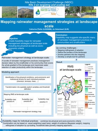
  • 1. Nile Basin Development Challenge (NBDC) Nile 3 on targeting and scaling out Mapping rainwater management strategies at landscape scale Catherine Pfeifer (ILRI/IWMI), An Notenbaert (ILRI) Conclusion: Objective : Objective Feasibility map suggests site-specific menu CreateCreate feasibility map • feasibility maps for rainwater of rainwater management practices to based on bio-physical and management strategies at landscape scale communities and smallholders including bio-physical as criteria socio- socio-economic well as for economic criteria management rainwater Up-coming challenges : • Mapping willingness of adoption strategies (RMS) • Define the borders of the landscape • Involve partners into the mapping • Develop a simple tool for partners Rainwater management strategy at landscape scale: A bundle of rainwater management practices (management decision taken by the smallholder or his community) that covers Result the whole gradient of the landscape and maximizes water retention or water productivity within the landscape. RMS Modeling approach Identification of bio-physical conditions, socio-economic and institutional drivers for each individual practices (diversion, terraces, trees,…) Transformation into spatially explicit variables and threshold definition Mapping RMS at landscape scale Criteria for Suitability map Suitability map Suitability map mapping : practice A practice B practice C Apple tree Min temp<10c Market <8 hours Luvisol, nitisol,  Plot size > 1 ha  leptosol Drought  risk< high Mango trees Nitisol Market <8 hours Sub‐humid zone Plot size > 1ha  Bench terracing  Semi‐arid‐humid Household size Access to advice  soils drain.≠ poor land frag. Slope 12‐58% Agri.dependency Hillside terracing Arid and semi‐arid Pop. density Access to advice  Rainwater management strategy map slope 10‐ 50% household size Land frag. plot size >1 ha  Agri.dependency River diversion 2.5km near river Access to capital Access to advise soil texture=fine household size Suitability maps for individual practices : combines bio-physical and socio-economic criteria Combination can be based on equal weighting (used here), weight of evidence (Bayesian weight), mapping willingness of adoption by up-scaling household data (poverty mapping approach) September 2011 http://nilebdc.wikispaces.com/ http://nilebdc.org/