SlideShare una empresa de Scribd logo
1 de 4
Descargar para leer sin conexión
This is a frame from a 3D video data set that was
created for the entire captured area. This deliverable
is of particular interest to the public safety community
for planning and preparedness workflows.


Lidar Unlocks
   Subterranean Philadelphia
                                                  C
            The City uses a blend                           enter City in Philadelphia is a        to build up the area while at the same
           of robotics and GIS for                          confluence of transportation,          time making certain the downtown
             an innovative project                          shopping, business and                 remains ready for business every day.
              below Market Street                 government agency activity, with several            To effectively serve the city, including
                                                  multi-level spaces (including under-             this bustling area, City staff relies on
                                                  ground) within a few blocks. The fifth           their GIS, which is based on Esri ArcGIS.
                                                  biggest region in the nation, Center City        Like most traditional GIS installations
                                                  also boasts the third-largest downtown           however, theirs did not include data for
                                                  population. The City of Philadelphia is          the insides of the Center City buildings
                                                  committed to encouraging business and            or the vast infrastructure under the
                                                  real estate development in the area and          streets. In order to maintain and grow
                 By Stu Rich                      has embarked on an innovative project            the City effectively, staff need a complete


                   Displayed with permission • LiDAR Magazine • Vol. 2 No. 2 • Copyright 2012 Spatial Media • www.lidarnews.com
A 3D LiDAR point cloud that is dimensionally accurate in real-world coordinates will be used as a beginning framework for the derivation of
multiple data sets used for architecture, engineering, construction planning, facilities asset inventories, emergency action planning and real
property space planning.


view of the infrastructure—both inside           develop spatially accurate floor map data        will be used as a beginning dimensional
and out—of buildings, railways and               of the underground infrastructure that           framework for the derivation of multiple
surrounding areas for their facilities           connects several notable buildings along         data sets from architecture, engineering,
management, public safety, space                 Market Street in Philadelphia.                   and construction planning to facilities
planning and real property departments.             PenBay provided this data to the City         asset inventories, emergency action
   PenBay Solutions, an Esri partner             in a building information system data            planning, and real property space plans.
headquartered in Brunswick, Maine, was           model (BISDM)-compliant data set, This              Also provided to the City is a set of
contracted by the City to provide facility       gives the City the capability to more            spherical images for the entire captured
management mapping services for a pilot          easily extend their existing GIS data            area. This deliverable should be of particu-
project aimed at testing the effectiveness       for a holistic, 3D GIS view of the City’s        lar interest to the public safety community
of a total 3D GIS solution. This service         busiest area when needed. Providing              for planning and preparedness workflows.
included interior data collection utilizing      data in a structured format allows City          This deliverable also provides assistance to
an innovative robotic platform employ-           staff to address issues more effectively         facilities managers in condition assess-
ing 3D LiDAR and spherical imagery               going forward.                                   ment and asset inventory.
technology, coupled with advanced                                                                    Last includes a set of in-building floor
global positioning systems (GPS) and             One cloud—many uses                              maps of the captured area. This deliver-
inertial measurement unit (IMU)                  This pilot project includes several              able should be of interest to real property
systems to develop vector floor map data         innovative deliverables.                         and space planners, as well as public
for specific areas of interest. The specific       First is a 3D LiDAR point cloud                safety. This provides the City a unique
platform used was the Trimble TIMMS              that will be dimensionally accurate in           view of their indoor space with reference
system. The focus of this effort was to          real-world coordinates. This deliverable         to the surrounding landscape.


                  Displayed with permission • LiDAR Magazine • Vol. 2 No. 2 • Copyright 2012 Spatial Media • www.lidarnews.com
The City of Philadelphia can analyze and manage their building infrastructure by using accurate and comprehensive spatial data information


Understanding the inside to                     fire extinguishers and other components           client, developed a detailed list of
make sense of outside space                     found within the rooms; and spherical             priorities, points of contact, access
The City’s challenge was to understand          images that are collected to guide anyone         dependencies, and geographic proximity
their building infrastructure better. They      who needs to access the space, such as            that allowed for the creation of a project
are interested in seeing the relationship       public safety officials, so they can get a real   plan and schedule to capture the data.
between: pedestrian concourses with             sense of what a space looks like.                 The decision was made to operate one
platforms, corridors, stair locations,             In order to effectively plan and execute       two-staff crew onsite under the control of
and ramps; ingress and egress points;           this project, a site assessment and               the project manager. This plan optimized
emergency access and air vent facilities;       requirements validation was conducted             the use of PenBay and client staff so that
connections between levels. Partial             at the client site. The goals of this activity    there would be a minimal impact on
interiors of a minimum of 3 buildings           were to validate deliverable requirements         building occupants, and client resources.
that connect to the defined pilot area;         and define data collection specifications;
and in-building floor maps. To effectively      identify project logistical support               Collecting data during
analyze and manage this critical public         requirements, discuss and validate                business hours
infrastructure they need access to accurate     project staging, access, and scheduling           Once the dates for the survey visit were
and comprehensive spatial data informa-         dependencies and visually inspect                 determined—the survey itself took
tion, including varied datasets that include    project areas of interest.                        place in the fall of 2010—PenBay started
data about space like rooms and how                Upon completion of the site visit,             the logistics necessary to mobilize the
they are being used; asset data, such as        PenBay staff, in conjunction with the             equipment and staff needed to execute


                 Displayed with permission • LiDAR Magazine • Vol. 2 No. 2 • Copyright 2012 Spatial Media • www.lidarnews.com
ADVERTISER 
                                                                                                     INDEX

                                                                                                     3D LASER MAPPING	                    29
                                                                                                     www.3dlasermapping.com

the data collection phase of the project.       robotics, PenBay was able to measure
                                                                                                     BLUE MARBLE GEOGRAPHICS	              9
Upon arrival at the client site, the survey     pertinent space in a fraction of the                 www.globalmapper.com
team closely coordinated their collection       time it takes with traditional collection
activities with the client. Since data          methods. Since these facilities are
                                                                                                     CARLSON SOFTWARE	                    21
collection happened mostly at night in          complex and have a high volume of                    www.carlsonsw.com
order to keep with Center City’s mission        pedestrian traffic, minimal survey
of not impacting the community,                 time and disruption was a critical                   CARDINAL SYSTEMS 	                  IBC
security escorts were provided by the           factor that PenBay was able to provide               www.cardinalsystems.net/
City for safety as well as to provide           with this highly efficient spatial data
unencumbered access to all areas,               collection method. The floor maps, or                EARTHEYE	15
such as the subway system and secure            georeferenced space plans, created by                www.eartheye.com
buildings. Staff took only 20 hours to          PenBay’s in-building data collection
collect all the data necessary for the          methodology were provided to give                    ERDAS 	                           5, 33
pilot project.                                  the City an accurate understanding of                www.erdas.com/LiDAR

   After completion of the data                 their current building space and floor
collection, PenBay initiated the data           materials within them.                               GEOCUE	25
                                                                                                     www.geocue.com
processing workflows that took the raw             With their city agency experience,
LiDAR point cloud data and spherical            PenBay provided the City with a GIS
imagery captured in the field and created       solution that employs a spatial data                 GEODIGITAL	7
                                                                                                     www.geodigital.com
several useful data products including          collection technology to collect a host of
CAD (AutoCAD) and 3D BIM (Revit)                information in one pass. The result is a
files of the area of interest and of course,    standards-compliant geodatabase useful               LEICA GEOSYSTEMS	                    41
                                                                                                     www.leica-geosystems.us
the primary deliverable of an ArcGIS            to multiple city agencies as an extension
geodatabase to make the files easily            of their existing GIS.
                                                                                                     LIZARDTECH	43
accessible to the City staff over the web.         PenBay helped the City collect and                www.lizardtech.com
   Through this pilot, PenBay was able          develop GIS-ready data sets in the form
to demonstrate how critical deliverables        of 2D and 3D map documents that
                                                                                                     MICROSOFT	27
can be created to support the City facili-      should be of particular interest to several          www.iFlyUltraCam.com
ties management initiative, including:          City service functions including Public
creating space definitions defining where       Safety, Evacuation Planning, Facility
                                                                                                     OPTECH	                           17, BC
boundaries such as hallways and rooms           Management and Lease Management                      www.optech.ca
beginning and end within the City GIS;          to make better informed decisions in
capturing floor plan data to represent          the future. The City now has a model                 RIEGL USA	                            3
interior space and structure accurately;        for a standards-compliant geodatabase                www.rieglusa.com
and performing facility surveys quickly,        that provides a holistic GIS view of its
safely and cost effectively. This survey        subterranean space and assets.                       SPAR INTERNATIONAL	                  23
provided the client with a clear and                                                                 www.sparpointgroup.com/International
                                                Stuart Rich is Chief Technology Officer at
accurate view of how their underground
                                                PenBay with more than 15 years experi-
infrastructure links to its above ground        ence developing database applications and            TOPCON 	                           IFC-1
buildings and roads.                            geographic information systems (GIS) for             www.topconpositioning.com/ips2/
                                                government and commercial organizations
                                                across the US and internationally. He has
Built for the future                            several years of extensive GIS experience,           VIRTUALGRID	19
                                                with an expertise in ESRI technology and a           www.vrmesh.com
In total, PenBay collected 340,000
                                                focus on project management, data analysis
square feet of designated infrastructure.       and modeling, business process analysis and
Using a combination of GIS and                  workflow methodology design.


                 Displayed with permission • LiDAR Magazine • Vol. 2 No. 2 • Copyright 2012 Spatial Media • www.lidarnews.com

Más contenido relacionado

La actualidad más candente

ArcGIS
ArcGISArcGIS
ArcGISEsri
 
Spring 2013
Spring 2013Spring 2013
Spring 2013Esri
 
Spring 2013
Spring 2013Spring 2013
Spring 2013Esri
 
GIS for Facilities Overview
GIS for Facilities OverviewGIS for Facilities Overview
GIS for Facilities OverviewEsri
 
Bathymetric Data Management
Bathymetric Data ManagementBathymetric Data Management
Bathymetric Data ManagementEsri
 
Real World Internet, Smart Cities and Linked Data: Mirko Presser (Alexandrea ...
Real World Internet, Smart Cities and Linked Data: Mirko Presser (Alexandrea ...Real World Internet, Smart Cities and Linked Data: Mirko Presser (Alexandrea ...
Real World Internet, Smart Cities and Linked Data: Mirko Presser (Alexandrea ...FIA2010
 
David Coleman: Challenging Traditional Models, Roles and Responsibilities in ...
David Coleman: Challenging Traditional Models, Roles and Responsibilities in ...David Coleman: Challenging Traditional Models, Roles and Responsibilities in ...
David Coleman: Challenging Traditional Models, Roles and Responsibilities in ...GSDI Association
 
Location analytics-put-the-where
Location analytics-put-the-whereLocation analytics-put-the-where
Location analytics-put-the-whereEsri
 
CC - Location based services - Global deployment & adoption trends - 2013
CC - Location based services - Global deployment & adoption trends - 2013CC - Location based services - Global deployment & adoption trends - 2013
CC - Location based services - Global deployment & adoption trends - 2013Yagna Teja D
 
Infrastructure of services for a smart city
Infrastructure of services for a smart cityInfrastructure of services for a smart city
Infrastructure of services for a smart cityIJCNCJournal
 
Esri GIS Trends for Transportation
Esri GIS Trends for TransportationEsri GIS Trends for Transportation
Esri GIS Trends for TransportationEsri
 
Multi Layer GIS Platform in Digital India - Mr. Vishnu Chandra
Multi Layer GIS Platform in Digital India - Mr. Vishnu ChandraMulti Layer GIS Platform in Digital India - Mr. Vishnu Chandra
Multi Layer GIS Platform in Digital India - Mr. Vishnu ChandraNeGD Capacity Building
 
Esri CityEngine
Esri CityEngineEsri CityEngine
Esri CityEngineEsri
 
Gis & Social Media Integration
Gis & Social Media IntegrationGis & Social Media Integration
Gis & Social Media IntegrationAllan Laframboise
 
The Smart City as a Data City - Google Tedx Talk
The Smart City as a Data City - Google Tedx Talk The Smart City as a Data City - Google Tedx Talk
The Smart City as a Data City - Google Tedx Talk 21cConsultancy_2012
 

La actualidad más candente (20)

ArcGIS
ArcGISArcGIS
ArcGIS
 
Spring 2013
Spring 2013Spring 2013
Spring 2013
 
Spring 2013
Spring 2013Spring 2013
Spring 2013
 
GIS for Facilities Overview
GIS for Facilities OverviewGIS for Facilities Overview
GIS for Facilities Overview
 
Bathymetric Data Management
Bathymetric Data ManagementBathymetric Data Management
Bathymetric Data Management
 
Maps Across Texas
Maps Across TexasMaps Across Texas
Maps Across Texas
 
Real World Internet, Smart Cities and Linked Data: Mirko Presser (Alexandrea ...
Real World Internet, Smart Cities and Linked Data: Mirko Presser (Alexandrea ...Real World Internet, Smart Cities and Linked Data: Mirko Presser (Alexandrea ...
Real World Internet, Smart Cities and Linked Data: Mirko Presser (Alexandrea ...
 
David Coleman: Challenging Traditional Models, Roles and Responsibilities in ...
David Coleman: Challenging Traditional Models, Roles and Responsibilities in ...David Coleman: Challenging Traditional Models, Roles and Responsibilities in ...
David Coleman: Challenging Traditional Models, Roles and Responsibilities in ...
 
Location analytics-put-the-where
Location analytics-put-the-whereLocation analytics-put-the-where
Location analytics-put-the-where
 
Ssgc Case Study Ibm
Ssgc Case Study   IbmSsgc Case Study   Ibm
Ssgc Case Study Ibm
 
Koordinates
Koordinates Koordinates
Koordinates
 
CC - Location based services - Global deployment & adoption trends - 2013
CC - Location based services - Global deployment & adoption trends - 2013CC - Location based services - Global deployment & adoption trends - 2013
CC - Location based services - Global deployment & adoption trends - 2013
 
Infrastructure of services for a smart city
Infrastructure of services for a smart cityInfrastructure of services for a smart city
Infrastructure of services for a smart city
 
Esri GIS Trends for Transportation
Esri GIS Trends for TransportationEsri GIS Trends for Transportation
Esri GIS Trends for Transportation
 
Multi Layer GIS Platform in Digital India - Mr. Vishnu Chandra
Multi Layer GIS Platform in Digital India - Mr. Vishnu ChandraMulti Layer GIS Platform in Digital India - Mr. Vishnu Chandra
Multi Layer GIS Platform in Digital India - Mr. Vishnu Chandra
 
Esri CityEngine
Esri CityEngineEsri CityEngine
Esri CityEngine
 
Gis & Social Media Integration
Gis & Social Media IntegrationGis & Social Media Integration
Gis & Social Media Integration
 
Utah Reorganizes its GIS Around Web Services
Utah Reorganizes its GIS Around Web ServicesUtah Reorganizes its GIS Around Web Services
Utah Reorganizes its GIS Around Web Services
 
GIS in Utah
GIS in UtahGIS in Utah
GIS in Utah
 
The Smart City as a Data City - Google Tedx Talk
The Smart City as a Data City - Google Tedx Talk The Smart City as a Data City - Google Tedx Talk
The Smart City as a Data City - Google Tedx Talk
 

Destacado

Esri 2011/2016 Updated Demographics
Esri 2011/2016 Updated DemographicsEsri 2011/2016 Updated Demographics
Esri 2011/2016 Updated DemographicsEsri
 
Esri News for State and Local Government Spring 2013 issue
Esri News for State and Local Government Spring 2013 issueEsri News for State and Local Government Spring 2013 issue
Esri News for State and Local Government Spring 2013 issueEsri
 
Esri US Market Potential Database Methodology Statement
Esri US Market Potential Database Methodology StatementEsri US Market Potential Database Methodology Statement
Esri US Market Potential Database Methodology StatementEsri
 
Esri News for Telecommunications 2013 newsletter
Esri News for Telecommunications 2013 newsletterEsri News for Telecommunications 2013 newsletter
Esri News for Telecommunications 2013 newsletterEsri
 
Building Mosaics
Building MosaicsBuilding Mosaics
Building MosaicsEsri
 
INIA- CISA: Análisis de las amenazas en la fauna silvestre
INIA- CISA: Análisis de las amenazas en la fauna silvestreINIA- CISA: Análisis de las amenazas en la fauna silvestre
INIA- CISA: Análisis de las amenazas en la fauna silvestreEsri
 

Destacado (6)

Esri 2011/2016 Updated Demographics
Esri 2011/2016 Updated DemographicsEsri 2011/2016 Updated Demographics
Esri 2011/2016 Updated Demographics
 
Esri News for State and Local Government Spring 2013 issue
Esri News for State and Local Government Spring 2013 issueEsri News for State and Local Government Spring 2013 issue
Esri News for State and Local Government Spring 2013 issue
 
Esri US Market Potential Database Methodology Statement
Esri US Market Potential Database Methodology StatementEsri US Market Potential Database Methodology Statement
Esri US Market Potential Database Methodology Statement
 
Esri News for Telecommunications 2013 newsletter
Esri News for Telecommunications 2013 newsletterEsri News for Telecommunications 2013 newsletter
Esri News for Telecommunications 2013 newsletter
 
Building Mosaics
Building MosaicsBuilding Mosaics
Building Mosaics
 
INIA- CISA: Análisis de las amenazas en la fauna silvestre
INIA- CISA: Análisis de las amenazas en la fauna silvestreINIA- CISA: Análisis de las amenazas en la fauna silvestre
INIA- CISA: Análisis de las amenazas en la fauna silvestre
 

Similar a Lidar Unlocks Subterranean Philadelphia

INTEGRATION OF BIM AND GIS
INTEGRATION OF BIM AND GISINTEGRATION OF BIM AND GIS
INTEGRATION OF BIM AND GISnandugagarin
 
Handheld augmented reality_for_underground_infrast
Handheld augmented reality_for_underground_infrastHandheld augmented reality_for_underground_infrast
Handheld augmented reality_for_underground_infrastHelloWorld121381
 
BIM - Esri UK Annual Conference 2016
BIM - Esri UK Annual Conference 2016BIM - Esri UK Annual Conference 2016
BIM - Esri UK Annual Conference 2016Esri UK
 
Max Bolen Resume 12202016
Max Bolen Resume 12202016Max Bolen Resume 12202016
Max Bolen Resume 12202016Max Bolen
 
Capture and Use of Geo-Located Asset Information using Reality Capture Techno...
Capture and Use of Geo-Located Asset Information using Reality Capture Techno...Capture and Use of Geo-Located Asset Information using Reality Capture Techno...
Capture and Use of Geo-Located Asset Information using Reality Capture Techno...David Males
 
React’s suitability to develop Geospatial solutions.pdf
React’s suitability to develop Geospatial solutions.pdfReact’s suitability to develop Geospatial solutions.pdf
React’s suitability to develop Geospatial solutions.pdfMindfire LLC
 
MODERN trends of GIS
MODERN trends of GISMODERN trends of GIS
MODERN trends of GISVAISHALI JAIN
 
Intern Project Summer 2015
Intern Project Summer 2015Intern Project Summer 2015
Intern Project Summer 2015Jacob Martinez
 
GIS 2.0 and Neogeography
GIS 2.0 and NeogeographyGIS 2.0 and Neogeography
GIS 2.0 and NeogeographyJoshua Campbell
 
Mobile BIM Poster Update Print
Mobile BIM Poster Update PrintMobile BIM Poster Update Print
Mobile BIM Poster Update PrintYingqi Liu
 
10549227d cybercity digitalcity
10549227d cybercity digitalcity10549227d cybercity digitalcity
10549227d cybercity digitalcitylsgi4321
 
Reasons to switch to geographic information system (gis) for civil engineering
Reasons to switch to geographic information system (gis) for civil engineeringReasons to switch to geographic information system (gis) for civil engineering
Reasons to switch to geographic information system (gis) for civil engineeringNI BT
 
GISenabledUrbanDesignAGSEPaper.pdf
GISenabledUrbanDesignAGSEPaper.pdfGISenabledUrbanDesignAGSEPaper.pdf
GISenabledUrbanDesignAGSEPaper.pdfSurenAdithyaaRA19112
 

Similar a Lidar Unlocks Subterranean Philadelphia (20)

INTEGRATION OF BIM AND GIS
INTEGRATION OF BIM AND GISINTEGRATION OF BIM AND GIS
INTEGRATION OF BIM AND GIS
 
Handheld augmented reality_for_underground_infrast
Handheld augmented reality_for_underground_infrastHandheld augmented reality_for_underground_infrast
Handheld augmented reality_for_underground_infrast
 
BIM - Esri UK Annual Conference 2016
BIM - Esri UK Annual Conference 2016BIM - Esri UK Annual Conference 2016
BIM - Esri UK Annual Conference 2016
 
John Mitchell resume
John Mitchell resumeJohn Mitchell resume
John Mitchell resume
 
Max Bolen Resume 12202016
Max Bolen Resume 12202016Max Bolen Resume 12202016
Max Bolen Resume 12202016
 
Mrp Intrim
Mrp IntrimMrp Intrim
Mrp Intrim
 
Capture and Use of Geo-Located Asset Information using Reality Capture Techno...
Capture and Use of Geo-Located Asset Information using Reality Capture Techno...Capture and Use of Geo-Located Asset Information using Reality Capture Techno...
Capture and Use of Geo-Located Asset Information using Reality Capture Techno...
 
React’s suitability to develop Geospatial solutions.pdf
React’s suitability to develop Geospatial solutions.pdfReact’s suitability to develop Geospatial solutions.pdf
React’s suitability to develop Geospatial solutions.pdf
 
MODERN trends of GIS
MODERN trends of GISMODERN trends of GIS
MODERN trends of GIS
 
Intern Project Summer 2015
Intern Project Summer 2015Intern Project Summer 2015
Intern Project Summer 2015
 
Geospatial Product Watch 2015
Geospatial Product Watch 2015Geospatial Product Watch 2015
Geospatial Product Watch 2015
 
CV-RAKESH KUMAR
CV-RAKESH KUMARCV-RAKESH KUMAR
CV-RAKESH KUMAR
 
( G . i . s )
( G . i . s )( G . i . s )
( G . i . s )
 
Manoj_Jawale_CV
Manoj_Jawale_CVManoj_Jawale_CV
Manoj_Jawale_CV
 
GIS 2.0 and Neogeography
GIS 2.0 and NeogeographyGIS 2.0 and Neogeography
GIS 2.0 and Neogeography
 
Mobile BIM Poster Update Print
Mobile BIM Poster Update PrintMobile BIM Poster Update Print
Mobile BIM Poster Update Print
 
GIS in Civil Engineering
GIS in Civil EngineeringGIS in Civil Engineering
GIS in Civil Engineering
 
10549227d cybercity digitalcity
10549227d cybercity digitalcity10549227d cybercity digitalcity
10549227d cybercity digitalcity
 
Reasons to switch to geographic information system (gis) for civil engineering
Reasons to switch to geographic information system (gis) for civil engineeringReasons to switch to geographic information system (gis) for civil engineering
Reasons to switch to geographic information system (gis) for civil engineering
 
GISenabledUrbanDesignAGSEPaper.pdf
GISenabledUrbanDesignAGSEPaper.pdfGISenabledUrbanDesignAGSEPaper.pdf
GISenabledUrbanDesignAGSEPaper.pdf
 

Más de Esri

Aena Aeropuerto Adolfo Suárez-Barajas crea potentes aplicaciones para sus cli...
Aena Aeropuerto Adolfo Suárez-Barajas crea potentes aplicaciones para sus cli...Aena Aeropuerto Adolfo Suárez-Barajas crea potentes aplicaciones para sus cli...
Aena Aeropuerto Adolfo Suárez-Barajas crea potentes aplicaciones para sus cli...Esri
 
Plataforma Smart City de Móstoles
Plataforma Smart City de MóstolesPlataforma Smart City de Móstoles
Plataforma Smart City de MóstolesEsri
 
ArcGIS Online para Organizaciones
ArcGIS Online para OrganizacionesArcGIS Online para Organizaciones
ArcGIS Online para OrganizacionesEsri
 
Molina de Segura se convierte en una smart city
Molina de Segura se convierte en una smart cityMolina de Segura se convierte en una smart city
Molina de Segura se convierte en una smart cityEsri
 
Portal for ArcGIS
Portal for ArcGISPortal for ArcGIS
Portal for ArcGISEsri
 
GIS-Based Web Services Provide Rapid Analysis and Dissemination of Maritime Data
GIS-Based Web Services Provide Rapid Analysis and Dissemination of Maritime DataGIS-Based Web Services Provide Rapid Analysis and Dissemination of Maritime Data
GIS-Based Web Services Provide Rapid Analysis and Dissemination of Maritime DataEsri
 
An Effective Tool for Drinking Water Protection
An Effective Tool for Drinking Water ProtectionAn Effective Tool for Drinking Water Protection
An Effective Tool for Drinking Water ProtectionEsri
 
GeoCollector for ArcPad
GeoCollector for ArcPadGeoCollector for ArcPad
GeoCollector for ArcPadEsri
 
GeoCollector for ArcGIS for Windows Mobile
GeoCollector for ArcGIS for Windows MobileGeoCollector for ArcGIS for Windows Mobile
GeoCollector for ArcGIS for Windows MobileEsri
 
Data Appliance for ArcGIS
Data Appliance for ArcGISData Appliance for ArcGIS
Data Appliance for ArcGISEsri
 
Esri and BlackBridge
Esri and BlackBridgeEsri and BlackBridge
Esri and BlackBridgeEsri
 
GeoPlanner for ArcGIS
GeoPlanner for ArcGISGeoPlanner for ArcGIS
GeoPlanner for ArcGISEsri
 
Esri and AccuWeather
Esri and AccuWeatherEsri and AccuWeather
Esri and AccuWeatherEsri
 
Esri and Airbus Defense & Space
Esri and Airbus Defense & SpaceEsri and Airbus Defense & Space
Esri and Airbus Defense & SpaceEsri
 
Esri US Data Fact Sheet
Esri US Data Fact SheetEsri US Data Fact Sheet
Esri US Data Fact SheetEsri
 
ArcGIS for Server on Microsoft Azure Jumpstart
ArcGIS for Server on Microsoft Azure JumpstartArcGIS for Server on Microsoft Azure Jumpstart
ArcGIS for Server on Microsoft Azure JumpstartEsri
 
ArcGIS for the Military--Maritime Operations
ArcGIS for the Military--Maritime OperationsArcGIS for the Military--Maritime Operations
ArcGIS for the Military--Maritime OperationsEsri
 
Esri Geoportal Server
Esri Geoportal ServerEsri Geoportal Server
Esri Geoportal ServerEsri
 
ArcGIS GeoEvent Extension for Server
ArcGIS GeoEvent Extension for ServerArcGIS GeoEvent Extension for Server
ArcGIS GeoEvent Extension for ServerEsri
 
The NATO Core Geographic Services System
The NATO Core Geographic Services SystemThe NATO Core Geographic Services System
The NATO Core Geographic Services SystemEsri
 

Más de Esri (20)

Aena Aeropuerto Adolfo Suárez-Barajas crea potentes aplicaciones para sus cli...
Aena Aeropuerto Adolfo Suárez-Barajas crea potentes aplicaciones para sus cli...Aena Aeropuerto Adolfo Suárez-Barajas crea potentes aplicaciones para sus cli...
Aena Aeropuerto Adolfo Suárez-Barajas crea potentes aplicaciones para sus cli...
 
Plataforma Smart City de Móstoles
Plataforma Smart City de MóstolesPlataforma Smart City de Móstoles
Plataforma Smart City de Móstoles
 
ArcGIS Online para Organizaciones
ArcGIS Online para OrganizacionesArcGIS Online para Organizaciones
ArcGIS Online para Organizaciones
 
Molina de Segura se convierte en una smart city
Molina de Segura se convierte en una smart cityMolina de Segura se convierte en una smart city
Molina de Segura se convierte en una smart city
 
Portal for ArcGIS
Portal for ArcGISPortal for ArcGIS
Portal for ArcGIS
 
GIS-Based Web Services Provide Rapid Analysis and Dissemination of Maritime Data
GIS-Based Web Services Provide Rapid Analysis and Dissemination of Maritime DataGIS-Based Web Services Provide Rapid Analysis and Dissemination of Maritime Data
GIS-Based Web Services Provide Rapid Analysis and Dissemination of Maritime Data
 
An Effective Tool for Drinking Water Protection
An Effective Tool for Drinking Water ProtectionAn Effective Tool for Drinking Water Protection
An Effective Tool for Drinking Water Protection
 
GeoCollector for ArcPad
GeoCollector for ArcPadGeoCollector for ArcPad
GeoCollector for ArcPad
 
GeoCollector for ArcGIS for Windows Mobile
GeoCollector for ArcGIS for Windows MobileGeoCollector for ArcGIS for Windows Mobile
GeoCollector for ArcGIS for Windows Mobile
 
Data Appliance for ArcGIS
Data Appliance for ArcGISData Appliance for ArcGIS
Data Appliance for ArcGIS
 
Esri and BlackBridge
Esri and BlackBridgeEsri and BlackBridge
Esri and BlackBridge
 
GeoPlanner for ArcGIS
GeoPlanner for ArcGISGeoPlanner for ArcGIS
GeoPlanner for ArcGIS
 
Esri and AccuWeather
Esri and AccuWeatherEsri and AccuWeather
Esri and AccuWeather
 
Esri and Airbus Defense & Space
Esri and Airbus Defense & SpaceEsri and Airbus Defense & Space
Esri and Airbus Defense & Space
 
Esri US Data Fact Sheet
Esri US Data Fact SheetEsri US Data Fact Sheet
Esri US Data Fact Sheet
 
ArcGIS for Server on Microsoft Azure Jumpstart
ArcGIS for Server on Microsoft Azure JumpstartArcGIS for Server on Microsoft Azure Jumpstart
ArcGIS for Server on Microsoft Azure Jumpstart
 
ArcGIS for the Military--Maritime Operations
ArcGIS for the Military--Maritime OperationsArcGIS for the Military--Maritime Operations
ArcGIS for the Military--Maritime Operations
 
Esri Geoportal Server
Esri Geoportal ServerEsri Geoportal Server
Esri Geoportal Server
 
ArcGIS GeoEvent Extension for Server
ArcGIS GeoEvent Extension for ServerArcGIS GeoEvent Extension for Server
ArcGIS GeoEvent Extension for Server
 
The NATO Core Geographic Services System
The NATO Core Geographic Services SystemThe NATO Core Geographic Services System
The NATO Core Geographic Services System
 

Último

TeamStation AI System Report LATAM IT Salaries 2024
TeamStation AI System Report LATAM IT Salaries 2024TeamStation AI System Report LATAM IT Salaries 2024
TeamStation AI System Report LATAM IT Salaries 2024Lonnie McRorey
 
New from BookNet Canada for 2024: BNC CataList - Tech Forum 2024
New from BookNet Canada for 2024: BNC CataList - Tech Forum 2024New from BookNet Canada for 2024: BNC CataList - Tech Forum 2024
New from BookNet Canada for 2024: BNC CataList - Tech Forum 2024BookNet Canada
 
Connect Wave/ connectwave Pitch Deck Presentation
Connect Wave/ connectwave Pitch Deck PresentationConnect Wave/ connectwave Pitch Deck Presentation
Connect Wave/ connectwave Pitch Deck PresentationSlibray Presentation
 
Ensuring Technical Readiness For Copilot in Microsoft 365
Ensuring Technical Readiness For Copilot in Microsoft 365Ensuring Technical Readiness For Copilot in Microsoft 365
Ensuring Technical Readiness For Copilot in Microsoft 3652toLead Limited
 
Designing IA for AI - Information Architecture Conference 2024
Designing IA for AI - Information Architecture Conference 2024Designing IA for AI - Information Architecture Conference 2024
Designing IA for AI - Information Architecture Conference 2024Enterprise Knowledge
 
SIP trunking in Janus @ Kamailio World 2024
SIP trunking in Janus @ Kamailio World 2024SIP trunking in Janus @ Kamailio World 2024
SIP trunking in Janus @ Kamailio World 2024Lorenzo Miniero
 
Are Multi-Cloud and Serverless Good or Bad?
Are Multi-Cloud and Serverless Good or Bad?Are Multi-Cloud and Serverless Good or Bad?
Are Multi-Cloud and Serverless Good or Bad?Mattias Andersson
 
TrustArc Webinar - How to Build Consumer Trust Through Data Privacy
TrustArc Webinar - How to Build Consumer Trust Through Data PrivacyTrustArc Webinar - How to Build Consumer Trust Through Data Privacy
TrustArc Webinar - How to Build Consumer Trust Through Data PrivacyTrustArc
 
Transcript: New from BookNet Canada for 2024: BNC CataList - Tech Forum 2024
Transcript: New from BookNet Canada for 2024: BNC CataList - Tech Forum 2024Transcript: New from BookNet Canada for 2024: BNC CataList - Tech Forum 2024
Transcript: New from BookNet Canada for 2024: BNC CataList - Tech Forum 2024BookNet Canada
 
CloudStudio User manual (basic edition):
CloudStudio User manual (basic edition):CloudStudio User manual (basic edition):
CloudStudio User manual (basic edition):comworks
 
Vertex AI Gemini Prompt Engineering Tips
Vertex AI Gemini Prompt Engineering TipsVertex AI Gemini Prompt Engineering Tips
Vertex AI Gemini Prompt Engineering TipsMiki Katsuragi
 
DevoxxFR 2024 Reproducible Builds with Apache Maven
DevoxxFR 2024 Reproducible Builds with Apache MavenDevoxxFR 2024 Reproducible Builds with Apache Maven
DevoxxFR 2024 Reproducible Builds with Apache MavenHervé Boutemy
 
DSPy a system for AI to Write Prompts and Do Fine Tuning
DSPy a system for AI to Write Prompts and Do Fine TuningDSPy a system for AI to Write Prompts and Do Fine Tuning
DSPy a system for AI to Write Prompts and Do Fine TuningLars Bell
 
Unraveling Multimodality with Large Language Models.pdf
Unraveling Multimodality with Large Language Models.pdfUnraveling Multimodality with Large Language Models.pdf
Unraveling Multimodality with Large Language Models.pdfAlex Barbosa Coqueiro
 
WordPress Websites for Engineers: Elevate Your Brand
WordPress Websites for Engineers: Elevate Your BrandWordPress Websites for Engineers: Elevate Your Brand
WordPress Websites for Engineers: Elevate Your Brandgvaughan
 
DevEX - reference for building teams, processes, and platforms
DevEX - reference for building teams, processes, and platformsDevEX - reference for building teams, processes, and platforms
DevEX - reference for building teams, processes, and platformsSergiu Bodiu
 
Unleash Your Potential - Namagunga Girls Coding Club
Unleash Your Potential - Namagunga Girls Coding ClubUnleash Your Potential - Namagunga Girls Coding Club
Unleash Your Potential - Namagunga Girls Coding ClubKalema Edgar
 
Anypoint Exchange: It’s Not Just a Repo!
Anypoint Exchange: It’s Not Just a Repo!Anypoint Exchange: It’s Not Just a Repo!
Anypoint Exchange: It’s Not Just a Repo!Manik S Magar
 
Story boards and shot lists for my a level piece
Story boards and shot lists for my a level pieceStory boards and shot lists for my a level piece
Story boards and shot lists for my a level piececharlottematthew16
 
"Debugging python applications inside k8s environment", Andrii Soldatenko
"Debugging python applications inside k8s environment", Andrii Soldatenko"Debugging python applications inside k8s environment", Andrii Soldatenko
"Debugging python applications inside k8s environment", Andrii SoldatenkoFwdays
 

Último (20)

TeamStation AI System Report LATAM IT Salaries 2024
TeamStation AI System Report LATAM IT Salaries 2024TeamStation AI System Report LATAM IT Salaries 2024
TeamStation AI System Report LATAM IT Salaries 2024
 
New from BookNet Canada for 2024: BNC CataList - Tech Forum 2024
New from BookNet Canada for 2024: BNC CataList - Tech Forum 2024New from BookNet Canada for 2024: BNC CataList - Tech Forum 2024
New from BookNet Canada for 2024: BNC CataList - Tech Forum 2024
 
Connect Wave/ connectwave Pitch Deck Presentation
Connect Wave/ connectwave Pitch Deck PresentationConnect Wave/ connectwave Pitch Deck Presentation
Connect Wave/ connectwave Pitch Deck Presentation
 
Ensuring Technical Readiness For Copilot in Microsoft 365
Ensuring Technical Readiness For Copilot in Microsoft 365Ensuring Technical Readiness For Copilot in Microsoft 365
Ensuring Technical Readiness For Copilot in Microsoft 365
 
Designing IA for AI - Information Architecture Conference 2024
Designing IA for AI - Information Architecture Conference 2024Designing IA for AI - Information Architecture Conference 2024
Designing IA for AI - Information Architecture Conference 2024
 
SIP trunking in Janus @ Kamailio World 2024
SIP trunking in Janus @ Kamailio World 2024SIP trunking in Janus @ Kamailio World 2024
SIP trunking in Janus @ Kamailio World 2024
 
Are Multi-Cloud and Serverless Good or Bad?
Are Multi-Cloud and Serverless Good or Bad?Are Multi-Cloud and Serverless Good or Bad?
Are Multi-Cloud and Serverless Good or Bad?
 
TrustArc Webinar - How to Build Consumer Trust Through Data Privacy
TrustArc Webinar - How to Build Consumer Trust Through Data PrivacyTrustArc Webinar - How to Build Consumer Trust Through Data Privacy
TrustArc Webinar - How to Build Consumer Trust Through Data Privacy
 
Transcript: New from BookNet Canada for 2024: BNC CataList - Tech Forum 2024
Transcript: New from BookNet Canada for 2024: BNC CataList - Tech Forum 2024Transcript: New from BookNet Canada for 2024: BNC CataList - Tech Forum 2024
Transcript: New from BookNet Canada for 2024: BNC CataList - Tech Forum 2024
 
CloudStudio User manual (basic edition):
CloudStudio User manual (basic edition):CloudStudio User manual (basic edition):
CloudStudio User manual (basic edition):
 
Vertex AI Gemini Prompt Engineering Tips
Vertex AI Gemini Prompt Engineering TipsVertex AI Gemini Prompt Engineering Tips
Vertex AI Gemini Prompt Engineering Tips
 
DevoxxFR 2024 Reproducible Builds with Apache Maven
DevoxxFR 2024 Reproducible Builds with Apache MavenDevoxxFR 2024 Reproducible Builds with Apache Maven
DevoxxFR 2024 Reproducible Builds with Apache Maven
 
DSPy a system for AI to Write Prompts and Do Fine Tuning
DSPy a system for AI to Write Prompts and Do Fine TuningDSPy a system for AI to Write Prompts and Do Fine Tuning
DSPy a system for AI to Write Prompts and Do Fine Tuning
 
Unraveling Multimodality with Large Language Models.pdf
Unraveling Multimodality with Large Language Models.pdfUnraveling Multimodality with Large Language Models.pdf
Unraveling Multimodality with Large Language Models.pdf
 
WordPress Websites for Engineers: Elevate Your Brand
WordPress Websites for Engineers: Elevate Your BrandWordPress Websites for Engineers: Elevate Your Brand
WordPress Websites for Engineers: Elevate Your Brand
 
DevEX - reference for building teams, processes, and platforms
DevEX - reference for building teams, processes, and platformsDevEX - reference for building teams, processes, and platforms
DevEX - reference for building teams, processes, and platforms
 
Unleash Your Potential - Namagunga Girls Coding Club
Unleash Your Potential - Namagunga Girls Coding ClubUnleash Your Potential - Namagunga Girls Coding Club
Unleash Your Potential - Namagunga Girls Coding Club
 
Anypoint Exchange: It’s Not Just a Repo!
Anypoint Exchange: It’s Not Just a Repo!Anypoint Exchange: It’s Not Just a Repo!
Anypoint Exchange: It’s Not Just a Repo!
 
Story boards and shot lists for my a level piece
Story boards and shot lists for my a level pieceStory boards and shot lists for my a level piece
Story boards and shot lists for my a level piece
 
"Debugging python applications inside k8s environment", Andrii Soldatenko
"Debugging python applications inside k8s environment", Andrii Soldatenko"Debugging python applications inside k8s environment", Andrii Soldatenko
"Debugging python applications inside k8s environment", Andrii Soldatenko
 

Lidar Unlocks Subterranean Philadelphia

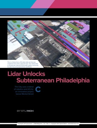
  • 1. This is a frame from a 3D video data set that was created for the entire captured area. This deliverable is of particular interest to the public safety community for planning and preparedness workflows. Lidar Unlocks Subterranean Philadelphia C The City uses a blend enter City in Philadelphia is a to build up the area while at the same of robotics and GIS for confluence of transportation, time making certain the downtown an innovative project shopping, business and remains ready for business every day. below Market Street government agency activity, with several To effectively serve the city, including multi-level spaces (including under- this bustling area, City staff relies on ground) within a few blocks. The fifth their GIS, which is based on Esri ArcGIS. biggest region in the nation, Center City Like most traditional GIS installations also boasts the third-largest downtown however, theirs did not include data for population. The City of Philadelphia is the insides of the Center City buildings committed to encouraging business and or the vast infrastructure under the real estate development in the area and streets. In order to maintain and grow By Stu Rich has embarked on an innovative project the City effectively, staff need a complete Displayed with permission • LiDAR Magazine • Vol. 2 No. 2 • Copyright 2012 Spatial Media • www.lidarnews.com
  • 2. A 3D LiDAR point cloud that is dimensionally accurate in real-world coordinates will be used as a beginning framework for the derivation of multiple data sets used for architecture, engineering, construction planning, facilities asset inventories, emergency action planning and real property space planning. view of the infrastructure—both inside develop spatially accurate floor map data will be used as a beginning dimensional and out—of buildings, railways and of the underground infrastructure that framework for the derivation of multiple surrounding areas for their facilities connects several notable buildings along data sets from architecture, engineering, management, public safety, space Market Street in Philadelphia. and construction planning to facilities planning and real property departments. PenBay provided this data to the City asset inventories, emergency action PenBay Solutions, an Esri partner in a building information system data planning, and real property space plans. headquartered in Brunswick, Maine, was model (BISDM)-compliant data set, This Also provided to the City is a set of contracted by the City to provide facility gives the City the capability to more spherical images for the entire captured management mapping services for a pilot easily extend their existing GIS data area. This deliverable should be of particu- project aimed at testing the effectiveness for a holistic, 3D GIS view of the City’s lar interest to the public safety community of a total 3D GIS solution. This service busiest area when needed. Providing for planning and preparedness workflows. included interior data collection utilizing data in a structured format allows City This deliverable also provides assistance to an innovative robotic platform employ- staff to address issues more effectively facilities managers in condition assess- ing 3D LiDAR and spherical imagery going forward. ment and asset inventory. technology, coupled with advanced Last includes a set of in-building floor global positioning systems (GPS) and One cloud—many uses maps of the captured area. This deliver- inertial measurement unit (IMU) This pilot project includes several able should be of interest to real property systems to develop vector floor map data innovative deliverables. and space planners, as well as public for specific areas of interest. The specific First is a 3D LiDAR point cloud safety. This provides the City a unique platform used was the Trimble TIMMS that will be dimensionally accurate in view of their indoor space with reference system. The focus of this effort was to real-world coordinates. This deliverable to the surrounding landscape. Displayed with permission • LiDAR Magazine • Vol. 2 No. 2 • Copyright 2012 Spatial Media • www.lidarnews.com
  • 3. The City of Philadelphia can analyze and manage their building infrastructure by using accurate and comprehensive spatial data information Understanding the inside to fire extinguishers and other components client, developed a detailed list of make sense of outside space found within the rooms; and spherical priorities, points of contact, access The City’s challenge was to understand images that are collected to guide anyone dependencies, and geographic proximity their building infrastructure better. They who needs to access the space, such as that allowed for the creation of a project are interested in seeing the relationship public safety officials, so they can get a real plan and schedule to capture the data. between: pedestrian concourses with sense of what a space looks like. The decision was made to operate one platforms, corridors, stair locations, In order to effectively plan and execute two-staff crew onsite under the control of and ramps; ingress and egress points; this project, a site assessment and the project manager. This plan optimized emergency access and air vent facilities; requirements validation was conducted the use of PenBay and client staff so that connections between levels. Partial at the client site. The goals of this activity there would be a minimal impact on interiors of a minimum of 3 buildings were to validate deliverable requirements building occupants, and client resources. that connect to the defined pilot area; and define data collection specifications; and in-building floor maps. To effectively identify project logistical support Collecting data during analyze and manage this critical public requirements, discuss and validate business hours infrastructure they need access to accurate project staging, access, and scheduling Once the dates for the survey visit were and comprehensive spatial data informa- dependencies and visually inspect determined—the survey itself took tion, including varied datasets that include project areas of interest. place in the fall of 2010—PenBay started data about space like rooms and how Upon completion of the site visit, the logistics necessary to mobilize the they are being used; asset data, such as PenBay staff, in conjunction with the equipment and staff needed to execute Displayed with permission • LiDAR Magazine • Vol. 2 No. 2 • Copyright 2012 Spatial Media • www.lidarnews.com
  • 4. ADVERTISER  INDEX 3D LASER MAPPING 29 www.3dlasermapping.com the data collection phase of the project. robotics, PenBay was able to measure BLUE MARBLE GEOGRAPHICS 9 Upon arrival at the client site, the survey pertinent space in a fraction of the www.globalmapper.com team closely coordinated their collection time it takes with traditional collection activities with the client. Since data methods. Since these facilities are CARLSON SOFTWARE 21 collection happened mostly at night in complex and have a high volume of www.carlsonsw.com order to keep with Center City’s mission pedestrian traffic, minimal survey of not impacting the community, time and disruption was a critical CARDINAL SYSTEMS IBC security escorts were provided by the factor that PenBay was able to provide www.cardinalsystems.net/ City for safety as well as to provide with this highly efficient spatial data unencumbered access to all areas, collection method. The floor maps, or EARTHEYE 15 such as the subway system and secure georeferenced space plans, created by www.eartheye.com buildings. Staff took only 20 hours to PenBay’s in-building data collection collect all the data necessary for the methodology were provided to give ERDAS 5, 33 pilot project. the City an accurate understanding of www.erdas.com/LiDAR After completion of the data their current building space and floor collection, PenBay initiated the data materials within them. GEOCUE 25 www.geocue.com processing workflows that took the raw With their city agency experience, LiDAR point cloud data and spherical PenBay provided the City with a GIS imagery captured in the field and created solution that employs a spatial data GEODIGITAL 7 www.geodigital.com several useful data products including collection technology to collect a host of CAD (AutoCAD) and 3D BIM (Revit) information in one pass. The result is a files of the area of interest and of course, standards-compliant geodatabase useful LEICA GEOSYSTEMS 41 www.leica-geosystems.us the primary deliverable of an ArcGIS to multiple city agencies as an extension geodatabase to make the files easily of their existing GIS. LIZARDTECH 43 accessible to the City staff over the web. PenBay helped the City collect and www.lizardtech.com Through this pilot, PenBay was able develop GIS-ready data sets in the form to demonstrate how critical deliverables of 2D and 3D map documents that MICROSOFT 27 can be created to support the City facili- should be of particular interest to several www.iFlyUltraCam.com ties management initiative, including: City service functions including Public creating space definitions defining where Safety, Evacuation Planning, Facility OPTECH 17, BC boundaries such as hallways and rooms Management and Lease Management www.optech.ca beginning and end within the City GIS; to make better informed decisions in capturing floor plan data to represent the future. The City now has a model RIEGL USA 3 interior space and structure accurately; for a standards-compliant geodatabase www.rieglusa.com and performing facility surveys quickly, that provides a holistic GIS view of its safely and cost effectively. This survey subterranean space and assets. SPAR INTERNATIONAL 23 provided the client with a clear and www.sparpointgroup.com/International Stuart Rich is Chief Technology Officer at accurate view of how their underground PenBay with more than 15 years experi- infrastructure links to its above ground ence developing database applications and TOPCON IFC-1 buildings and roads. geographic information systems (GIS) for www.topconpositioning.com/ips2/ government and commercial organizations across the US and internationally. He has Built for the future several years of extensive GIS experience, VIRTUALGRID 19 with an expertise in ESRI technology and a www.vrmesh.com In total, PenBay collected 340,000 focus on project management, data analysis square feet of designated infrastructure. and modeling, business process analysis and Using a combination of GIS and workflow methodology design. Displayed with permission • LiDAR Magazine • Vol. 2 No. 2 • Copyright 2012 Spatial Media • www.lidarnews.com