Improved agricultural water management in the Nile Basin: interventions analysis – hydronomic zoning
•
0 recomendaciones•368 vistas

Poster by Demissie, S.S.; Awulachew S.B. and Molden, D. for: CPWF Nile Basin Focal Project Final Workshop, Dar es Salaam, Tanzania, 9 December 2009.
Recomendados

Recomendados
Más contenido relacionado
Más de ILRI
Más de ILRI (20)
Último
Último (20)
Improved agricultural water management in the Nile Basin: interventions analysis – hydronomic zoning
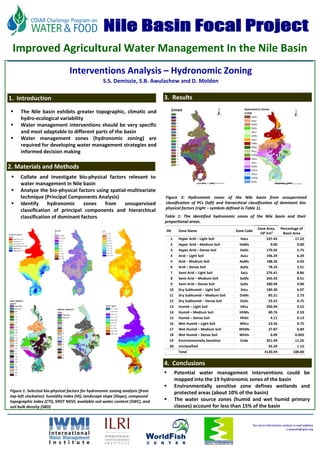
- 1. FU Berlin Improved Agricultural Water Management In the Nile Basin Interventions Analysis – Hydronomic Zoning S.S. Demissie, S.B. Awulachew and D. Molden 1. Introduction 3. Results The Nile basin exhibits greater topographic, climatic and hydro‐ecological variability Water management interventions should be very specific and most adaptable to different parts of the basin Water management zones (hydronomic zoning) are required for developing water management strategies and informed decision making 2. Materials and Methods Collate and investigate bio‐physical factors relevant to water management in Nile basin Analyze the bio‐physical factors using spatial‐multivariate technique (Principal Components Analysis) Figure 2: Hydronomic zones of the Nile basin from unsupervised Identify hydronomic zones from unsupervised classification of PCs (left) and hierarchical classification of dominant bio‐ physical factors (right – symbols defined in Table 1). classification of principal components and hierarchical classification of dominant factors Table 1: The identified hydronomic zones of the Nile basin and their proportional areas. Zone Area, Percentage of SN Zone Name Zone Code 106 km2 Basin Area 1 Hyper Arid – Light Soil HaLs 537.45 17.22 2 Hyper Arid – Medium Soil HaMs 0.00 0.00 3 Hyper Arid – Dense Soil HaDs 179.45 5.75 4 Arid – Light Soil AaLs 196.29 6.29 5 Arid – Medium Soil AaMs 188.26 6.03 6 Arid – Dense Soil AaDs 78.24 2.51 7 Semi Arid – Light Soil SaLs 276.41 8.86 8 Semi Arid – Medium Soil SaMs 265.43 8.51 9 Semi Arid – Dense Soil SaDs 280.94 9.00 10 Dry Subhumid – Light Soil DsLs 189.30 6.07 11 Dry Subhumid – Medium Soil DsMs 85.21 2.73 12 Dry Subhumid – Dense Soil DsDs 23.52 0.75 13 Humid – Light Soil HhLs 296.99 9.52 14 Humid – Medium Soil HhMs 80.76 2.59 15 Humid – Dense Soil HhDs 4.11 0.13 16 Wet Humid – Light Soil WhLs 23.56 0.75 17 Wet Humid – Medium Soil WhMs 27.87 0.89 18 Wet Humid – Dense Soil WhDs 0.09 0.003 19 Environmentally Sensitive EnSe 351.49 11.26 20 Unclassified 35.24 1.13 Total 3120.59 100.00 4. Conclusions Potential water management interventions could be mapped into the 19 hydronomic zones of the basin Environmentally sensitive zone defines wetlands and Figure 1: Selected bio‐physical factors for hydronomic zoning analysis (from protected areas (about 10% of the basin) top‐left clockwise): humidity index (HI), landscape slope (Slope), compound topographic index (CTI), SPOT NDVI, available soil water content (SWC), and The water source zones (humid and wet humid primary soil bulk density (SBD) classes) account for less than 15% of the basin For more information contact: e‐mail address s.seyoum@cgiar.org