Web Based GIS LeadGen Introduction
•Descargar como PPSX, PDF•
3 recomendaciones•424 vistas

This is an introduction to InteractiveGIS and what we offer as a web based GIS solution.
![Key features – Output: Print engineer-grade, scaled maps in a wide variety of sizes. The Print Manager provides the ability to select, view, manage, and print maps ranging in size from 8.5" by 11" (ANSI A) to 34" by 44" (ANSI E). All of which are plotted to scale. ,[object Object]](data:image/gif;base64,R0lGODlhAQABAIAAAAAAAP///yH5BAEAAAAALAAAAAABAAEAAAIBRAA7)
Recomendados
Más contenido relacionado
Similar a Web Based GIS LeadGen Introduction
Similar a Web Based GIS LeadGen Introduction (20)
Último
Último (20)
Web Based GIS LeadGen Introduction
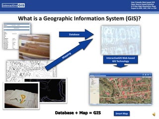
- 1. What is a Geographic Information System (GIS)? Database Mapping InteractiveGIS Web-based GIS Technology Database + Map = GIS Smart Map
- 3. Markup Tools (not available on this version)
- 6. Print Output ModeEver try to fit an entire water distribution system on an 8.5 by 11 inch piece of paper?
- 7. Key features – Customizability: no matter your web-based GIS needs, we’ve designed a solution A Map of the Area of Interest Your Electronic Filing Cabinet Enhanced Rollover – Coming Soon! CCTV Video Inspection
- 9. The term open source refers to any freely-distributed software whose source code is intentionally made available for people to examine and modify.
- 10. InteractiveGIS is Built on the Open Source Software MapServer®
- 11. Developed by NASA & University of Minnesota
- 12. No GIS Experience Necessary
- 13. Point and Click Functionality
- 14. Most people already know how to work an Internet browser
- 15. Immediate Savings on ALL Software Costs
- 16. Your Budget is Focused on Developing the Required Tools
- 20. Maps you can draw on digitally
- 21. More levels of connection between your items of data
- 23. Add Lines
- 24. Add Text
- 25. Definable Line Weights, Colors, and Text/Symbol Size
- 26. Clear Markup by Step or Clear All
- 30. The Tool Bar Zoom In - zooms-in by either clicking on the map or by drawing a box around the region of interest. Zoom Out - zooms-out by either clicking on a point on the map near the region of interest. Zoom Extents- Displays the full geographic extent of all visible layers. Pan - Click on the map and drag the cursor with the left mouse button down. This will move the view extent in any direction. Identify - Click on a feature within the map to display attribute information. The information is shown on the Results tab. Measure - This tool is used to measure distance and/or area on the map. This information is displayed at the bottom of the interface. Rectangle/Point Feature Selection - This tool is used to make a rectangular or circular selection of features found on the map. Polygon Feature Selection - This tool is used to make a selection within the polygon of features found on the map.
- 31. Map View Tab Map View Tab Quick Zoom Zoom to a Community Zoom to a Public Building Quick Search Enables the user to search by any one or all of the following: Parcel Account Number Owner (if registered user) Street Number E-911 Address Selection Tools (used in conjunction with tool bar rectangle and polygon selection tools) Identify which layer to search Specify the search buffer distance Markup Buttons Reset Cancel Clear
- 32. Data Search InteractiveGIS is the link between data and real-world features The Digital Filing Cabinet Easy as 1-2-3…4! 2 3 4 1
- 33. Data Search
- 34. Data Search
- 35. Data Search
- 36. Just the Facts Just the Facts (JTF) is a very powerful tool by itself to look at a specific feature. It not only gives the user detailed information about feature but it also gives additional spatial information about the surrounding area. Print - Sends the results to the printer. Email - Opens up Microsoft Office's Outlook and generates the appropriate link.
- 37. Drill-down Identification The Selection tool provides the user the ability to select multiple features, from the same layer, by performing a single action. Returning more information quicker.
- 38. Map Layers Tab To control the visibility of a map layer, complete the following steps: Select the Map Layers tab Locate the layer of interest Click the checkbox to toggle the visibility of that layer Click the Update button located at the bottom of the side panel. The system will regenerate a new map with only the selected layers visible.
- 40. Enter a deed book and page number and hit Search.
- 41. Range Searches
- 42. Enter a range for the Acreage and press Search.
- 43. Enter a Map Number or rangeThe results are displayed on the Results tab.
- 44. Results Tab - Initial Returns Initial Results - Regardless of how the search was initiated, the Results Tab will provide a list of features that either matched the selection criteria or were returned as the result of one of the selection tools. Note that at the top of the Result Tab the system provides a critical piece of information about how the system understood what the user was searching: Search Query: Owner equals smith Note - the above statement describes how the system understood your query. If this is incorrect please adjust your query and retry. The initial results provide links to additional information
- 45. Results Tab - Detailed Information Detailed Results come from the user selecting the blue hyperlinked text from one of the Initial Results records. Depending on the feature selected, more detailed information will be displayed in the side panel. The detailed results provide additional information
- 48. Detailed Online Help & Training The Help button is located at the top right of the interface. Easily Updated since it is on the server – no costly updates to distribute “Users Manuals” and covers all topics in one place. General Side Panel Toolbar Preference & Settings Map View Tab Map Layer Tab Search Tab Results Tab Just the Facts Print Manager The Help Button