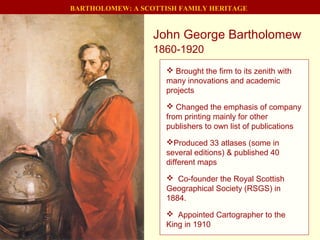
1. John George Bartholomew
1860-1920
BARTHOLOMEW: A SCOTTISH FAMILY HERITAGE
Brought the firm to its zenith with
many innovations and academic
projects
Changed the emphasis of company
from printing mainly for other
publishers to own list of publications
Produced 33 atlases (some in
several editions) & published 40
different maps
Co-founder the Royal Scottish
Geographical Society (RSGS) in
1884.
Appointed Cartographer to the
King in 1910
2. John George Bartholomew 1860-1920
BARTHOLOMEW: A SCOTTISH FAMILY HERITAGE
His flair: Recognise which titles
could become bestsellers with many
reprints
His friends included many well
known figures (academics and
writers).
A Benevolent manager,
recreational activities for staff and a
unique profit-sharing scheme.
Reserved and studious. Insistence
on accuracy and quality in all his work
made him an exacting employer.
His greatest accomplishments: The
Times Survey Atlas of the World and
championing layer-colouring
3. BARTHOLOMEW: A SCOTTISH FAMILY HERITAGE
Bartholomew and Nelson's merge and
move into the Parkside Works on
Gibbet Loan in 1888 (soon renamed
Park Road!)
The firm leaves Chamber’s Street and
is re-christened as the Edinburgh
Geographical Institute
5. On the rats in Park Road...
"They seldom appeared in the daytime but one day when we were all
busy at work, one of the draughtsmen (Beveridge) jumped up and
knocked over his stool with a great clatter. Next we saw him standing
with his hand behind his back clutching at the top of his trousers. A few
moments afterwards he jerked out the back of this shirt and a dead rat
fell out on the floor"
James Bain, Bartholomew draughtsman, 1880s
BARTHOLOMEW: A SCOTTISH FAMILY HERITAGE
[Slide after: Chris Fleet, NLS]
6. BARTHOLOMEW: A SCOTTISH FAMILY HERITAGE
Palladian frontage taken from Falcon Hall in Morningside, where the
family had lived from 1899 to 1907 before it was demolished.
1911: Move to Duncan Street
7. BARTHOLOMEW: A SCOTTISH FAMILY HERITAGE
1890’s: Railway continued to be one of the most solid clients
14. BARTHOLOMEW: A SCOTTISH FAMILY HERITAGE
John George Bartholomew worked with Sir John Murray on mapping the
findings of the H.M.S. Challenger Expedition (1873-76).
H.M.S. Challenger
15. BARTHOLOMEW: A SCOTTISH FAMILY HERITAGE
John George was the first to put the name “Antarctica” on the map…
16. John George’s sketches
for Royal Scottish
Geographical Society
Inaugural Event 1884;
Banquet 1890.
BARTHOLOMEW: A SCOTTISH FAMILY HERITAGE
John George Bartholomew: Co-founder of the Royal Scottish
Geographical Society
Three generations would play key roles at the R.S.G.S.
17. John George kept a log with charming sketches and watercolours sketches aboard
the Sobraon, to South Africa and Australia.
BARTHOLOMEW: A SCOTTISH FAMILY HERITAGE
John George heads off to Australia in 1881 aged 21.
24. BARTHOLOMEW: A SCOTTISH FAMILY HERITAGE
Family Journals: A holiday pastime for the whole family through two generations
25. BARTHOLOMEW: A SCOTTISH FAMILY HERITAGE
John George Bartholomew’s descendants: A close knit family still identifies closely
with the family’s map-making legacy
26. John “Ian” Bartholomew
1890-1962
BARTHOLOMEW: A SCOTTISH FAMILY HERITAGE
He led firm confidently through both
wars and difficult times
Adds modern rotary printing presses
Creates innovative map projections
Initiation of World Series and important
family of atlases were seminal.
Published Times Atlas Mid-Century
Edition, 5 vols., then designed 1-volume
Times Comprehensive Atlas (published
after his death).
Followed John George as President of
the RSGS from 1920 to 1954
31. BARTHOLOMEW: A SCOTTISH FAMILY HERITAGE
Great War: Ian Bartholomew: Active Service: Trenches and later Intelligence work
Ian was commissioned in 1914 into
the 1st Battalion, Gordon Highlanders
and served in France and Flanders.
He was mentioned three times in
dispatches and was awarded the
Military Cross in 1915.
His younger brother Hugh was killed
in the war.
Later he served on Haig's staff at St.
Omer and Montreuil as a staff-captain
of Intelligence.
32. BARTHOLOMEW: A SCOTTISH FAMILY HERITAGE
WW2: Supporting the war effort: Escapee maps for MI9
33. BARTHOLOMEW: A SCOTTISH FAMILY HERITAGE
WW2: Supporting the war effort: Escapee maps for MI9
37. BARTHOLOMEW: A SCOTTISH FAMILY HERITAGE
From Ian’s photo albums….
Ian takes a break in the trenches
near Ypres, 1915
38. BARTHOLOMEW: A SCOTTISH FAMILY HERITAGE
Minou, his wife, in the "Yellow
Peril"
Ian at the wheel in King's
Park, Edinburgh (1920).
39. BARTHOLOMEW: A SCOTTISH FAMILY HERITAGE
Prince Philip of Greece was in
Edinburgh for the weekend as guests of
the family 14-16 June 1935
Silver Wedding 1945, with photographs on
the table of their two WWII, John and Peter
sons in service.
40. Map of Edinburgh Zoo, 1932 –
by John “Ian” Bartholomew,
later kept up to date by his son
John as layout changed and
animal’s were moved around
BARTHOLOMEW: A SCOTTISH FAMILY HERITAGE
Edinburgh Zoo
The gates of Edinburgh Zoo originally came from Falcon Hall (with the
Falcons). John George Bartholomew’s family lived at Falcon Hall 1898-1907
41. BARTHOLOMEW: A SCOTTISH FAMILY HERITAGE
A collective legacy built from the continuity between generations
“It is moving to see how a son in each case would see
through what his father had started.” - Alick Bartholomew
42. John C. Bartholomew 1923-2008
Peter H. Bartholomew 1924–1987
Robert G. Bartholomew 1927
BARTHOLOMEW: A SCOTTISH FAMILY HERITAGE
John joins 1949. From 1953, has
cartographic direction. Bartholomew mapping
standards upheld while modernised. Engaged
in key organisations in UK and internationally.
Robert joins 1953. From 1955 manages all
production and investments in printing and
bindery technology.
Peter joins 1956, becomes Chairman, with
managerial control, until afflicted by series of
strokes.
Outside directors appointed - financial,
management and marketing strength added.
Company is sold to Reader’s Digest in
1980; then to News International in 1985.
43. BARTHOLOMEW: A SCOTTISH FAMILY HERITAGE
1976 – Celebration of 150 Years
1980 – Sale of John Bartholomew
& Son Limited to Reader’s Digest
1985 – Sale to News International
1995 – Move to Collins Geo in
Bishopbriggs
44. Printing Record
Business Record
Reference Library
Printed maps
Proof mapsCopper PlatesGlass Plates
Principal Contents
Causewayside, Edinburgh
BARTHOLOMEW: A SCOTTISH FAMILY HERITAGE
45. BARTHOLOMEW: A SCOTTISH FAMILY HERITAGE
Finally….The interactive digital future? Good or bad thing for cartography?
John George (1860–1920) Prince of Cartographers – Dad’s hero - This Walton painting Built on John Jr’s rich range of maps and atlases, bringing the firm to its zenith Changed the emphasis of the company from printing for other publishers to building up his own list of publications, thereby increasing profitability A balance between bread & butter lines with major projects like The Times Survey Atlas of the World Many innovations, and a series of more academic titles and many distinguished atlases e.g. The World Atlas of Zoogeography and The World Atlas of Meteorology ( incomplete project). Completed the Half-inch Series of England & Wales and Scotland His flair was to recognise which titles could become bestsellers that would be reprinted ten or more times. John George expanded printing to 14 gas driven flat-beds Moved company to better premises for growth: Park Road and then Duncan Street Took on really big projects, e.g. the Survey Atlases of Scotland (1895) and England (1904) on a half-inch scale, taxed the firm’s resources. His greatest accomplishment: The Times Survey Atlas of the World . (did not live to see publication) John George inherited his father’s desire to make international contacts. Co-founder the Royal Scottish Geographical Society (RSGS) in 1884. He also financed a readership of geography at Edinburgh University. (alas not a chair of geography). Poor health: prevented him from pursuing his father’s love of travel. He did this remotely, by summoning the great explorers to come and lecture at the RSGS in Edinburgh. He counted many well known figures (academics and writers) as his friends. He was reserved and studious and his insistence on accuracy and quality in all his work made him an exacting employer. Benevolent manager, organising recreational activities for his staff and a unique profit-sharing scheme (unheard of at the time). Produced 33 atlases (some in several editions) & published 40 different maps Published the Quarter-inch Series, separately, of England, Scotland & Ireland Firm became international institution 1910, awarded the royal warrant as geographer and cartographer to the King John George (1860–1920) succeeded his father in 1888 and built on his rich range of maps and atlases, bringing the firm to its zenith with many innovations, and a series of more academic titles and many distinguished atlases (like The World Atlas of Zoogeography ) . He counted many well known figures (academics and writers) as his friends. He completed the Half-inch Series in 1903, which with the popularity of cycling, of the motorcycle and then the car, became the firm’s bread and butter for two generations. His flair was to recognise which titles could become bestsellers, reprinting ten or more times. The print numbers increased (half a million London plans for the 1897 jubilee celebrations; 225,000 timetable maps for the L&NW Railway). But JGB also took on really big projects, some of which, like the Survey Atlases of Scotland (1895) and England (1904) on a half-inch scale, taxed the firm’s resources. His greatest accomplishment was The Times Survey Atlas of the World . Sadly, he did not live to see its publication. Ian brought it out soon after his father’s untimely death. John George inherited his father’s desire to make international contacts. He was a co-founder the Royal Scottish Geographical Society (RSGS) in 1884. He also financed a readership of geography at Edinburgh University. It was his son who saw his dream realised of the establishment of its first chair of geography. His poor health prevented him from pursuing his father’s love of travel. Instead he did this remotely, by summoning the great explorers to come and lecture at the RSGS in Edinburgh. There were still vast unmapped areas of the world, so John George became a virtual explorer. He was reserved and studious and his insistence on accuracy and quality in all his work made him an exacting employer. But John George was a benevolent one, organising recreational activities for his staff and a unique profit-sharing scheme (unheard of at the time). He was ambitious and his life displayed a kind of élan that contributed to the success of his business: as with his renting as the family home the extravagant Palladian house of Falcon Hall and, following its demolition, making its impressive pillared frontage the main feature of his new Geographical Institute on Duncan Street. Do look at the photos on the family website to get an impression of this! JGB — Changed the emphasis of the company from printing for other publishers to building up his own list of publications, thereby increasing profitability Completed the Half-inch Series of England & Wales and Scotland A balance between bread & butter lines with major projects like The Times Survey Atlas of the World Produced 33 atlases (some in several editions) and published 40 different maps Published the Quarter-inch Series, of Great Britain and separately of Ireland Firm became an international institution, winning medals at exhibitions, and also for himself In 1910 he was awarded the royal warrant as geographer and cartographer to George V, and to three further sovereigns, which lapsed in 1962 on the death of his son. The German school of cartography was pre-eminent, and four generations of Bartholomews widened their knowledge by studying with the German masters. John Jr. studied for two years (1855) with Augustus Petermann. John George’s son Ian studied in Leipzig (1907-8) with Oswald Winkel. His grandson John Christopher carried on the tradition, sitting at the feet of Edouard Imhof, the great Swiss cartographer, in Berne and Zurich in 1960, and his son John Eric followed in 1977 with Imhof’s pupil, Ernst Spiess.
He also financed a readership of geography at Edinburgh University. It was his son who saw his dream realised of the establishment of its first chair of geography.
Moved company to better premises for growth: Park Road and then Duncan Street
John George expanded printing to 14 gas driven flat-beds John George expanded the printing department to cope with the increased demand for maps, from his father’s three steam presses, to 14 gas driven flat-beds, first at Park Road and then at Duncan Street (single colour presses, 800 sheets/hr.; one was still in use in the 1970s).
Some of Bartholomew’s most reliable clients were railway companies. Bartholomew printed everything from posters and maps to luggage labels and timetables.
NLS website – exlore and zoom in on its wonders – fading in and out of different plans at different times
John George Bartholomew worked with Sir John Murray on mapping the findings of the H.M.S. Challenger Expedition (1873-76).
John George and the Royal Scottish Geographical Society John George Bartholomew’s personal and professional achievements demonstrate that he was able to overcome his problems, however. In essence, this is because John George was unfaltering in his belief that the pursuit of geographical knowledge and research could be a means of advancing both the subject and society. He was a founder member of the Scottish Geographical Society (later the Royal Scottish Geographical Society, RSGS), an ardent advocate of Patrick Geddes’ proposed ‘National Institute of Geography’ and a supporter of the creation of a Chair of Geography at the University of Edinburgh, although he would not live to see this achieved. He was also keen to see an improvement in the teaching of geography in Scottish schools, and proposed an RSGS committee to this end. Beyond his commercial achievements, it is the creation of the Royal Scottish Geographical Society for which John George is most widely remembered. A paragraph from John George’s original draft for the Society’s first prospectus shows that he saw and stressed a national as well as an intellectual value in developing a more complete understanding of Scotland’s geography: It is therefore one of the first objects of the Scottish Geographical Society to advance the study of Geography in Scotland; to impress the Public with the necessity and inestimable value of a thorough knowledge of Geography in a commercial, scientific, or political education: so that its importance and utility may be fully recognised, and that it may attain the position due to it as an essential branch of education in the higher schools and universities, such as it has long held in the universities of the Continent, notably in those of Germany. 1 2 His closing words in reference to Germany are telling. John George was aware not only of John Junior’s cartographic apprenticeship with Petermann, but he was also alluding to Germany’s advances in geography more generally. However, whilst John George felt it necessary to pay due deference to the skills of German cartographers and geographers, his concern in supporting the creation of the RSGS was directed at Scotland and Scottish geography: ‘Scotland has always held her place in the front rank of science, art, and commerce; and the Scottish Geographical Society will, it is hoped, in this respect enhance the national reputation.’ 1 3 When the RSGS was officially established, John George was only 24 years old. From its inception until his death, he was Honorary Secretary not only of the RSGS but also of an exclusive club called ‘Ye Argonauts’ whose second constitutional law stated that ‘the main object of the Club shall be the promotion of geographical work, more especially in connection with the interests of the Scottish Geographical Society and its Magazine.’ 1 4 If the success of the Royal Scottish Geographical Society was perhaps John George’s most significant personal achievement, it was by no means his only one. Throughout his life, he received a succession of honours and titles including Fellowships of the Royal Society of Edinburgh in 1887 and of the Royal Geographical Society in 1888. He was awarded an honorary degree of Doctor of Laws from the University of Edinburgh in 1909, and he enjoyed honorary membership of international societies such as the Société de Géographie, Paris, the Imperatorskoe Russkoe Geographiteskoe Obshchestvo in St Petersburg and the Hungarian Geographical Society, amongst others. Nevertheless, for all of his personal successes and failures, his flaws and strengths, it was the firm, John Bartholomew & Co. and his place at its head which truly defined John George Bartholomew.
JGB a hard act to follow! John (Ian) (1890–1962) he gave a role to three of his sons – a military type – could be source of friction with dad! Remember he studies cartography in Paris and Leipzig too! A shy man, he did not push himself forward. Creative in his own way: e.g. Created brilliant new map projections – better ways to portray a round globe on a flat surface. Introduction of modern rotary printing presses (esp. Roland), Initiation of the World Series and important family of atlases were seminal. He brought out the impressive Mid-Century edition of the Times Atlas in five volumes, which was largely tactical and to spread the enormous investment; Vol 3 (Europe) came out in 1955, the last 5 years later. Acknowledging that this was unwieldy, he subsequently designed a one-volume edition, The Times Comprehensive which was not published until after his death. Developed the Mid-Century & the Comprehensive editions of The Times Atlas Arranged the Half-inch series of Scotland and of England & W. into a national series of 62 maps and the Quarter inch into a national series of 22 maps Developed the concept of the Reader’s Digest Great World Atlas LLD from Edinburgh University (like JGB) Ian followed John George as President of the RSGS from 1920 to 1954.
The great atlases of the 1900’s: Citizens – first Handy Reference Gazetter Survey Atlas (B.I.) Advanced Atlas of Modern Geography
Dad’s obituary photo!!!!!
Recap: So how did each of these fine men help shape what Bartholomew’s became? George: founder of the dynasty as the first engraver. John Senior : Went into business on his own as an Engraver John Junior: Added draughtsmanship ; lithographic printing John George : Moved company into publishing – firmly established Bartholomew as world-renowned cartographic name. John (Ian): Guided company though challenging times completing his fathers work Dad: Continued to assure the cartographic standards – focused much time internationally How family assured continuity? Alick says : It’s moving is how a son in each case would see through what his father had started. 1) John Junior embraces the concept of layer colouring: JGB experiments more with it makes it happen. 2) Times Atlas project initiated by John George and almost completed on his death. Ian: saw it published, and started work at once on the Mid-Century edition (5 vols.) Dad: Oversaw completion of the more commercially viable Comprehensive edition in 1967
John was more of a scholarly and artistic bent, at times reluctant to compromise on quality. Comprehensive Times Atlas ; Family Atlas, and others Dads Output: 1967 – Times Comp - Completion of father’s project 1970 – RAB, RAE 1972 – Times spin-off’s: Concise – and other Times atlases (moon, history.) 1981 + RD G. W. Atlases – 20+ editions, many languages – the most sold copies of any large format book perhaps? 1983 – Family Atlas [JB Pub] Special projects like Atlas of Norway; Seeking fast track to modern mapping partnership with Esselte in Sweden for modern popular look (land colouring – precursor to satellite images today) We were all trying this. I did that in 1978 at K+F for Morocco
The changeover to the next generation was not so smooth. No one in the family who was able to continue the level of cartographic innovation demonstrated by the previous three Johns. John (Christopher) (1923-2008) Started as cartographer in 1949, after an initial apprenticeship Cartographic director in 1953. More emphasis on contracted printing work, like The Times Moon Atlas (1969), The Times Atlas of World History (1978) and the huge Reader’s Digest series of some 20 national atlases (1963+), A fastidious and knowledgeable editor and a skilled cartographer. Found it hard to compromise on quality. He continued the work of his father and grandfather as a contributor to geographical and cartographic conferences and was highly respected in international circles. John lacked managerial skills and became concerned for the future continuity of the business. John was more of a scholarly and artistic bent. Like his forebears before him, he was President of to the RSGS His ultimate accomplishment was to organise the transfer of the Bartholomew Archive to the Scottish National Library. Robbie (1927– ) Joined the firm in 1953 Has spent some time in London with the firm’s wholesalers. Became production director in 1955. Peter (1924–1987) 1956 return to Edinburgh to take over management of the firm. Skill was the ability to sensitively to get the managers to work as a team. 1961 he appointed David Cunningham as financial director. In the late ‘60s he had one heart attack after the other, and realised he had to slow down. 1969 Peter headhunted David Ross Stewart, who had had broad managerial experience, to be managing director, and Mike Chittleburgh in 1972 as marketing director. Peter’s first stroke, and the weakening position of the firm on the marketplace, made it inevitable that the family would have to give up control of the business. With continuing ill health, Peter must have felt that there would be no one of his determination, commitment and ability to turn the firm around. When things started to go wrong – Alick’s analysis / controversial? The firm had lost its prominence as the premier British cartographer, and was in a weak position financially . 1972, the very successful Half-inch Series was replaced by the larger scale of 1:100,000 –(government’s decimalisation policy) - a costly disaster, for the new National Series and discontinued after a few years. Traditional family businesses difficulty to adapt to a modern market-driven economy. Few are able to make the transition successfully. Particularly hard for an artistic and craftsman-based company like Bartholomew, but it was amplified in the 1960s by the market’s change in taste and several companies producing a simpler style in maps. The firm was not able to adjust quickly enough with raft of large format, low priced road atlases and new, well-designed popular map series . Attitude problem. 150 years the trend setter: So equated with quality mapping that there had been no real challengers. Not adequately prepared for the free and rapidly expanding market of the 1960s and ‘70s. General public was demanding simpler, bolder mapping. The AA and petrol companies were producing cheap road maps, and the O.S. developed popular tourist maps, selling them aggressively. David Ross Stewart position: Massive growth of subsidised competition: Government policy: Margaret Thatcher’s reply when challenged: that it was necessary to reduce the cost to the public purse of the OS and that it had to go commercial to raise its income. We had a major competitor (guaranteed to have all its losses underwritten). The OS pursued an aggressive development of its publishing and marketing . They launched their own road atlas and many other products such as street atlases. The OS always ran at a huge loss for which the taxpayer picked up the bill: This was acceptable whilst their only widely retailed publication was their 1”/50,000 mapping, since this did not really compete with the unsubsidised private sector. When using OS data bases ever-increasing royalties and had to declare the sales of each such publication to a major competitor! Automobile Association, once a customer, became another major subsidised competitor . The AA was then flush with cash from its fast growing membership and, with a much enlarged drawing office, launched into travel book publishing on an almost RD scale, including a range of road atlases and street atlases. 1980 After the 1980 sale, three Reader’s Digest directors, with Jack O’Hara as CEO, were appointed. David Ross Stewart effectively still ran the company Peter took a back seat. After a second stroke in 1983, he came in just to open the post. 1984 The new board realised that the firm’s data storage systems were inadequate for modern times, so Robin Orr was appointed in 1984 to investigate converting the map archive into digital form. Eventually Pleasantville (RD’s hq) lost confidence in O’Hara; he was fired and RD decided also to shed his favourite baby, Bartholomew, which they sold in 1985 to News International (the UK subsidiary of News Corp which was controlled by Rupert Murdoch’s family). For the first few years, Bartholomew’s sales increased considerably. Murdoch bought Harper & Row in New York and Collins in London & Glasgow; Geographia and Nicholson in London were now part of Bartholomew,
Thank you’s .....John Murray fund – a year before dad died My brothers and I here at the front would love to meet you! > A big thank you again Chris, Karla > But also Julian Russell, Diane Webster, Margaret Wilkes championed the cause > Funding from family of John Murray
As much as I love that too – my wish is that there will always be a core of interest in generations to come that appreciate holding a well designed paper map in their hands. And I do believe that paper maps and bound atlases will still have their fans until well after I’m gone.