
Recomendados
Más contenido relacionado
Destacado
Poster - Summary of Field Guide
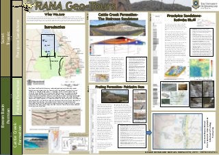
- 1. Buranga Leichardt Faults Site 1 Site 2 Site 3 Mimosa Syncline Surat Triassic BowenBasin Permian CattleCreek Formation PrecipiceSandstoneFreitagFormation 280Ma260Ma195Ma RANA Geo-Tours is an Australian based private company, driven to provide reliable and affordable, quality fieldtrips for industry, and interested public groups, explaining geological outcrops in detail with a hands-on practical approach offered no-where else. The tour guides are fully accredited geologists. The site locations chosen provide a unique learning experience and insights into the merging of ancient and modern day geological formations. Prices range from $5000 - $7500 depending on availability. Bookings are essential. No refunds available. Each customer will be given the opportunity to purchase the RANA Geo-Tours field guide, T-Shirt, Hat and commemorative photos. Study Area Upper delta plain Unit 1 – Brahmaputra Braided River, India Unit 2 – Rhine-Meuse Delta - Avulsion Anastomosing, Saskatchewan River , Canada Unit 3 – Delta Mouth Bar Unit 4 – Chenier Plain, Danube Delta, Romania Modern Analogues – Bulimba Bluff Paleo-Depositional Environment Zoophycos- bathyal zone 100 – 2000 m below sea level Cruziana and Skolithos (Diplocraterion) – sandy shoreface up to 100 m below sea Cruziana (Arenicolites) and smaller Skolithos vertical burrows 0 – 10 m foreshore Ichnofacies The Freitag Formation is exposed at Fairbairn Dam as a triangular shaped outcrop, 30 m high by 200 m wide, with its units easily discernible due to changes in colour and essentially planar contacts between beds (from orange for sandstones to greys for recessive siltstones). The outcrop is located on the western margin of the Bowen Basin (see map). The Freitag Formation represents a Permian aged paralic coastal to shallow marine system which is supported by its subsurface gamma signature and isopach thickness (Left images). The Freitag is a small, coarsening up sequence and has considerable lateral extent in the subsurface. Its trace is similar to the coarsening up sequence of a delta and can be compared against the predicted signature of a fluvial system. The isopach map shows an elongated, southward progradiing geometry, which rapidly thins towards the south and its margins. This is broadly analogous to the mid and outer Great Barrier Reef shelf thickness distribution, and may indicate that wave dominated processes were a significant feature affecting deposition of the Freitag Formation. The stratigraphic column at a scale 1:50 (left) describes the sedimentary rocks observed in the field. This is to be read in conjunction with their depositional environment interpretation below: The Cattle Creek group has several exposures in the Springsure area. The outcrop of the Staircase Sandstone was at a large road cutting south of the town’s centre. Standing at approximately 14 m and 110 m long, this outcrop has six units. This group represents the depositional environment that resulted from a thermal relaxation event with marine shelf activity (Mollan, R.G, 1969). Evidence of deltaic style deposition is embodied through the presence of herringbone cross- stratification, Ophiamorpha burrows and trough cross beds. The deltaic environment was overlain by mudstone indicating a base level rise, which deposited distal mudstone over the coarse sandstone lobes. 1. Proximal Deltaic Lobe massive medium sandstone with troughs, herringbone and ripple beds. Within the nearshore, oxygenated waters (Ophiamorpha burrows). Presence of soft-sediment deformation and escape structures indicating rapid depositional event. 2. Deltaic Lobe with channel inlets: Pebble lags within sigmoidal lenses have been attributed to rapidly changing channels frequently being built and abandoned within the delta. 3. Fluvial influenced Deltaic Lobe with unidirectional paleocurrent: Over-steepened beds within dunes represent the seaward migration within a major estuarine channel. 4. Distal Deltaic Lobe: Paleocurrent shift indicating another lobe ‘switch back’- similar direction to unit 3. Contains wave ripples, siderite staining, clean quartz which implies wave oscillation. 5. Sandy-Tidal flat: Laminated sandy mudstone with siderite replacement and manganese staining. Coarsening upward with sandstone pulses representing high energy storm events. 6. Tidal Channel Inlet: Massive tabular body of finely bedded pebbly sandstone with a sharp erosive contact. Displays some ripples (or large dunes) and coarse pebble lag. KEY Learnings: The Staircase Sandstone outcrop provides a unique opportunity to observe lateral features which represent the changing depositional environment of a delta through time. It was shown within this outcrop that shifting paleocurrents are indicative of deltaic lobe switching similar to what can be observed in the modern day Mississippi River. A close examination of ichnofacies also allows for interpretation of proximal-distal relationships within each lobe. The depositional sub-environment of the outcrop are summarised below: KEY Learnings: Many modern day environments are extremely complex: varying in shape, size and lateral continuity and can be difficult to compare to ancient systems. The Freitag succession has been interpreted in this filed guide to closely resemble a coastal barrier tidal flat which grades into an overlying estuary deposit at the top of the outcrop. It preserves excellent marine trace fossils and sedimentary structures such as: Skolithos burrows and trough -hummocky cross- stratification with wave dominated ripples in the sandstones. Maximum flooding surfaces are also seen in the pebble to cobble conglomerate lags with some authors attributing their presence from a marine transgression. Mississippi River Delta Lobe Switching Site2Site1 1. Barrier Island – Tidal Flat: Planar to sub-parallel laminated micaceous/carbonaceous mudstone interbedded with fine sandstone sheets and lenses, poorly sorted, quartz rich, lenticular to flaser gradational bedding with ripple cross lamination. 2. Anoxic swamp – marsh: jointed bright-banded black coal with sharp contacts 3. Tidal Channel Inlet: Massive, tabular, pebble-cobble polymict para- conglomerate, quartz dominated, subrounded, poorly sorted with pervasive pluck marks and coal/ carbonaceous mudstone sigmoid lenses with erosive and sharp contacts 4. Inner- outer marine shelf: Thick trough cross bedded coarse to very coarse, bioturbated quartz arenite sandstone with ripple cross beds, well sorted and well rounded with ironstone and quartz granules throughout and glauconite. This large unit pinches out. 5. Flood tidal delta - Tidal bar (ebb shield) : Manganese stained silty claystone with wave ripples, subparallel lenticular and convolute bedding and flame structures. Paleocurrent multidirectional 6. Flood tidal inlet: Very coarse, sandstone, low angle bi-directional planar and trough/hummocks cross-beds, (quartz arenite –subarkose) with heavy bioturbation at bottom and iron stone precipitation 7. Distributive channel – Estuary: highly porous, medium to coarse, thinly bedded sandstone in laminated bedsets with mudstones 10-15 cm, with cobble sized intraclasts of sandstone and pebbly gravel lenses. Paleocurrent average 268ºSW to W Left: Freitag Formation Isopach Map - thickness distribution (m) Below: Wireline Gamma Signatures of Delta and Fluvial Settings & comparison to Freitag’s Gamma response. Australia’s Great Barrier Reef – Modern Analogue to the Freitag Formation Site3 AncientDepositional EnvironmentInterpretation SchematicFreitag Formation 1. Braided River: Coarse, porous, highly porous quatzose sandstone with erosional scours, trough cross beds, conglomerate, planar cross-stratification and ripple cross stratification. Also contains rip up clasts and log fossil clasts (derived from a high gradient hinterland). Unimodal paleocurrent. 2. Anastomosing deranged river: coarse to medium pebbly sandstone with large planar and low-angle cross-stratification potentially representing the splitting of flow around a channel bar, dune migration or from channel avulsion. More widely varying paleocurrent N to NE (interpreted to be a result of avulsion and related tectonic activity from the Buranga fault as- well as from lower gradients offering greater resistance to flow) 3. Delta mouth bar – supratidal flat: coarsening upward sandstones from laminated pro-delta clays (extremely muscovite and calcite rich) to distributary channel and bar sands interfingered with interdistributary muds. Presence of Skolithos vertical burrows and an Ophiamorpha crab burrow within lobe’s coarser centre and ripple beds towards the finer grained sides of the lobe. 4. Coastal Chenier Plain: Mudflat/marsh with bioturbation followed by a sharp-erosive washover unit of re-worked medium sandstone with trace brackish fossils and shells interbedded with fine siltstone, followed by beach ridge dunes 5. Evergreen Formation – meandering river and lake: Poorly exposed and not extensively mapped - thin rippled lamination, low angle cross beds, asymmetrical ripples, animal tracks and shells. Interference ripples over large symmetrical ripples on the top of the outcrop could indicate past anti-dunes, The Jurassic aged Precipice Sandstone is the oldest unit in the Surat Basin and is exposed across the Carnarvon Ranges (see map). The section of outcrop mapped, was along the walking trail up Bulimba Bluff within the Carnarvon National Park (approx. 76 m high) The Precipice sandstone is separated into two discrete units: the Precipice Upper and the Precipice Lower. The Upper member is a lower quality reservoir rock - composed of interbedded siltstone with intermittent thin sandstone lenses. The Lower member is a high quality reservoir rock characterised by: high porosity/permeabilty with coarse grained, pebbly quartz rich sandstone and conglomerate with minor siltstone. KEY Learnings: The isopach map shows this formation thinning westward onto the Roma Shelf and thickening on the basin ward side of the Triassic thrust fault system (see map). The formation is at its thickest along the Mimosa Syncline where it is interpreted an ancient river system, as large as the Ganges Brahmaputra in India, was directed along SE. Authors suggest this river initially was sourced from Antarctica (when Australia formed part of Gondwana), across the Eromanga Basin and finally changing course to the south in the Bowen Basin. Abrupt thinning and cessation of the unit along the north-eastern flank was likely a result of steepening along the Burunga Fault. The stratigraphic column at a scale 1:50 (left) describes the sedimentary rocks observed in the field. This is to be read in conjunction with their depositional environment interpretation and schematics below: Zoomed in Precipice Formation Thickness (m) MEGGIE DORAN AND MICHAEL KOWALCZYK, 2015 – ERTH3103/7411 The Bowen-Surat Basin fieldtrip uses a sedimentological approach to describe ancient depositional environments from the Permo-Jurassic time period at a series of outcrops including: 1.) Emerald, Fairbairn Dam, 2.) Springsure, Cattle Creek Formation and 3.) Carnarvon Gorge, Bulimba Bluff. Environments observed range from coastal successions, marine shoreface tidal sequences and fluvial successions. It was concluded that many sedimentary features observed within outcrops could be compared to modern day analogues such as: the Mississippi River, United States, Ganges Brahmaputra, India and Bribie Island, Queensland. The Bowen Basin is of regional importance for coal seam gas and coal mining. As approximately 60% of all fossil fuel reservoirs throughout the world are found within fluvial- deltaic depositional settings, the interpretation of ancient clastic environments and understanding their lateral distribution through the subsurface becomes crucial for industry productivity. The below seismic image from QGC shows the Permo-Triassic Bowen Basin and overlying Jurassic Surat Basin. Merivale Fault System