Pulau Banyak Rapid Assessment
•
2 recomendaciones•4,067 vistas

Post December 24, 2004 and 28 March, 2005 Sumatera Tsunami Damage Assessment. In Aceh most remote Banyak Archipelago, which consist of 99 islands. One of them is the biggest green turtle rookery in Western Indonesia.

Recomendados
Más contenido relacionado
Similar a Pulau Banyak Rapid Assessment
Similar a Pulau Banyak Rapid Assessment (20)
Más de Monica Kuhon
Más de Monica Kuhon (9)
Pulau Banyak Rapid Assessment
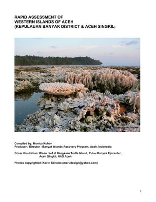
- 1. RAPID ASSESSMENT OF WESTERN ISLANDS OF ACEH (KEPULAUAN BANYAK DISTRICT & ACEH SINGKIL) Compiled by: Monica Kuhon Producer / Director - Banyak islands Recovery Program, Aceh, Indonesia Cover illustration: Risen reef at Bangkaru Turtle Island, Pulau Banyak Epicenter, Aceh Singkil, NAD Aceh Photos copyrighted: Kevin Scholes (merudesign@yahoo.com) 1
- 2. ACKNOWLEDGEMENTS This rapid assessment was made possible with assistance support from, Meru Design - USA, GMM Film Productions – Jakarta and a team of people from the Gaia Surf Charter who’s helped enable the smooth running of this exercise from start to the end, all which assistance has been much welcomed. Special thanks are given to Kevin Scholes, for his guidance and photography throughout the process, and the continuous online technical assistance from Cédric Vernet, Sean Hynes and Jeremy Allen. Particular thanks also to Hester Kuhon, Gary Hayes, Marcus and Myles Keyshan for their considerable support throughout this mission. In Aceh, steady Data Collections and advice from the Head District/Police/Head of Military of Pulau Banyak, Singkil, NAD Aceh has been much appreciated. Finally thanks to the survivors of the earthquake and tsunami with whom we met and spoke to during this assessment, in particular the residence of Singkil, students and teachers of Pulau Balai, and village residence in Haluban in Pulau Tuangku, and Pulau Thailana whose own harrowing story is unfortunately shared by many. Despite their losses, they took considerable time to spend with the RA mission to guide and advise us on many lines of enquiry, in the hope that something positive would emerge from this process. That hope is shared by all who participated in this RA. For more information on please contact: Monica Kuhon Producer / Director - Banyak islands Recovery Program, Aceh, Indonesia Website: banyakislands.com Telephone: (62) 08174786489, Email: kuhon@asia-mail.com, turtle_aceh@yahoo.com, turtleisland@mailbolt.com, monica@banyakislands.com, 2
- 3. EXECUTIVE SUMMARY Introductions Between 09 and 28 May 2005 our voluntary team conducted a rapid assessment of the damage to communities by recent earthquake and tsunami, to identify critical environmental issues resulting from the natural disaster of earthquake and tsunami, we also investigate where environmental considerations should and might be taken into account in other sectors. Objectives The main objective of the assessment was to examine the present logistic and programme situations on the Banyak Group of Islands, Aceh Singkil. Findings from this assessment are expected to stimulate further action of relief in designated areas, initially through elaboration of a more detailed, formal, environmental impact assessment (or, most likely, a series of assessments), and subsequently to assist in the design and implementation of future plans for rehabilitation and reconstruction of Pulau Banyak, Aceh Singkil. Method Given the need to conduct an assessment of this nature in a short a time as possible, in the process we thrive to be open and transparent as possible, while still attempting to ensure that as many sources of information have been identified in the process. In this instance, the results do not represent the observations or opinions of one person alone, input from both local community , stake holders and district government were crucial to the identification of issues and concerns, as the RA process depends to a high degree on support their experiences and knowledge to contribute the of the formulation of recommended actions. As is the nature of this RA methodology, work was to be largely based on field data collection, but without forgetting the importance of secondary data sources collections, primarily summaries of the regions history, journals of scientific research publications, as well as other data compiled by the international donor/co-ordination group working in the region. Conclusion In summary, our field data findings conclude that, the western islands being situated right at the epicenter of the earthquake had suffered considerable damage, which will take years to overcome. . Mercifully, prior experience to such events, local preparedness and proximity to high ground saved the population. The challenge now is to help safeguard the lives and livelihoods those communities which have been so resourceful in surviving the trials of earthquake and tsunami, by developing common understanding on the essential purpose in act of Mother-nature bringing the world attention to this beautiful and remote tropical archipelago. And by uniting available knowledge to ensure that these marvelous ecosystems will continue to provide sustainable services for the communities into the future. 3
- 4. THE LOCATION 1. Aceh Westcoast 1.1 General Characteristics of Wetlands on the Coast of Aceh Detailed data about the wetland ecosystem of coast of Aceh is scarce when compared to other provinces in Indonesia. This has to do in part to the security situation in Aceh, which meant that it was unsafe and difficult to carry out survey activities. Furthermore the western coast of Sumatra faces directly into the Indian Ocean, which is deep and open, there are large waves, and the contours of the coast are curam and the substrate is sand. Photograph of a typical coastal area on the west coast of Aceh. Photograph by Efrizal Adil (Partner of WI-IP). 1.2 Climate Its tropical positioning provides a hot humid climate with a wet season between June and November, the ‘Western Season’ or southwest monsoon, and a dry season between November and May, the ‘Eastern Season’ or northeast monsoon,. The ‘Western Season’ is characterized by strong winds from the west making the western and northern coasts prone to very large waves. (*Stringell) Photo©Bohemian 4
- 5. The difference in contours, height of waves and type of substrate between the east and west coasts means that the dominant types of wetlands differ. On the east coast of Aceh there are many mangrove ecosystems comprised of Rhizophora. Coastal trees such as ketapang, coconuts, and pandan dominate the west coast, and there are many coral reef ecosystems. It is rare to find a mangrove ecosystem. (*WI-IP) 2. Aceh Singkil Singkil is the principal trading town of Kabupaten Tingkat II Aceh Singkil Region (total area 8.910 Km2), situated at the mouth of the confluence of River Simpang Kanan and Simpang Kiri at the Singkil River. 5
- 6. The town (area 3.964 Km2) is protected to the west by a swampy headland which diminished the effect of the 1.5 – 2 m wave which struck the Island on 26 December 2004. The total population recorded for the region in 1998 was 113.002, spread thru 4 Districts, . i. Kecamatan Simpang Kiri; ii. Kecamatan Sinipang Kanan; iii. Kecamatan Singkil; iv. Kecamatan Pulau Banyak. 6
- 7. 2.1 Coastal Communities (Cultural, History & Religious Beliefs) Towards the end of the 12th century we find traces of apparently indigenous Muslims on the north coast of Sumatra, where a few kingdoms or rather harbour states arose. Perlak and the twin kingdom of Samudra and Pasai in Aceh, located on the very tip of Sumatra, were major pepper-producing area and due to international trade became the most splendid kingdoms of the period. Its rulers patronized the arts and sciences and made it into the region's chief centre of Islamic knowledge, This time coincides with the period of flourishing of medieval Sufism and the growth of the sufi orders (tarékat), the tarékat was perceived as a source of spiritual power, at once legitimating and supporting the ruler's position. As illustrated by the brief history, many local scholars were sent abroad to Arabia and when this batch of student came back they brought along with them the tarékat that they learnt from their teachers. One of them was ", Abdurra'uf of Singkil who became Aceh most celebrated mystics, also known in Aceh as Teungku di Kuala, since his tomb is situated near the kuala of mouth of the Singkil river. Abdurra'uf spiritual guide and teacher in the way of God was Ahmad Qushashi of Medina, who initiated him in the Shattarite fraternity order (tarékat Shattariya), which originated in India and came to the East Indies by way of Mekka and Medina It was through the tarékat Shattariya that sufi metaphysical ideas and symbolic classifications based on doctrine that is till now part of West Sumatrans popular beliefs, and later easily accommodated itself with local tradition; it became the most "indigenized" of the orders , where Indonesians were initiated. Abdul Rauf of Singkil, studied in Mecca and Medina for 20 years and came back to Aceh in 1661 as a faqih and sufi master, his book "Umdat al-muhtajin ila suluk maslak al-mufridin" (Support of those desirous to walk in the way of the "solitaries"), contains directions for practising the various methods of dhikr (zikir), and a discourse on the ethics of the conscientious mystic, in which a number of precepts respecting moral conduct abstracted from the ethical literature of Islamic mysticism are summed up. Abdul Ra'uf of Singkil most probably was responsible for the rendering into Malay of Qasd al-sabil. This was a commentary on a work by al-Qusyasyi, al-`Aqida al-Manzuma, which in rhyming verse stated his beliefs. As is evident from its contents, the text in this manuscript was produced in an environment of a mystical Islamic order (tarékat). 7
- 8. Islam community in Singkil until this day is still pervaded with a mystical attitude and a fascination with the miraculous. The tarékat order also fulfill a number of functions that are not religious even in a loose sense, tarékat is also a social network, and membership in a tarékat yields a number of potentially useful social contacts. Especially for recent migrants to the city, the tarékat network may prove useful in finding work, a place to live, help in difficulties, etcetera. The tarékat is for some members also a replacement of the family, offering the warmth and protection they do not find elsewhere. The gradual demise of traditional society appears not, as has at times been assumed, to cause the inevitable decline of the tarékat but rather to give them new social functions and entire new categories of followers. Habitat The wetland of West Singkil is located at 2 o36’36’’N and 97 o45’0’’E and has an area of 5,500 ha. It consists of relatively undisturbed beach forest series and freshwater swamp forests in excellent condition; it is the best surviving examples of these habitat types in the province, with all their characteristic flora and fauna. The West Singkil wetland also has a number of protected fauna: - Rare Sandanglawe (Ciconia stormi) - Vulnerable Sayap putih duck (Cairina scutulata), Bangau tong-tong (Leptoptilos javanicus), Rangkong papan (Buceros bicornis),Alap-alap Cina (Accipiter soloensis),Rangkong kecil (Anthracoceros albirostris),Enggang hitam (Anthracoceros malayanus), Rangkong badak (Buceros rhinoceros),Elang laut perut putih (Haliaeetus leucogaster),Elang bondol (Haliastur indus),Elang laut kelabu, (Ichthyophaga ichthyaetus),Blue-crowned Hanging Parrot (Loriculus galgulus), Punggok (Ninox scutulata),Elang madu (Pernis ptilorhynchus),Long-tailed Parakeet (Psittacula longicauda), Blue- rumped Parrot (Psittinus cyanurus), Elang ular (Spilornis cheela),Elang hitam (Spizaetus cirrhatus) (*WI-IP) Other Environmental Status UNITED NATIONS EDUCATIONAL, SCIENTIFIC AND CULTURAL ORGANIZATION CONVENTION CONCERNING THE PROTECTION OF THE WORLD CULTURAL AND NATURAL HERITAGE WORLD HERITAGE COMMITTEE Twenty-eighth session Suzhou, China (28) June - 7 July 2004 8
- 9. I Recommended for inscription I* Recommended for inscription with reservations D Recommended for deferral OK Approval Recommended of an extension or a modification N Not recommended for inscription C/N (i) (ii) etc Cultural or Natural criteria recommended. Italicized C/N indicates that the original property has already been inscribed on the World Heritage List CL Proposed as a Cultural Landscape 9
- 10. 10
- 11. Nominations of properties to the World Heritage List WHC-04/28.COM/14B REV, p. 4 KEY 11
- 12. 3. Pulau Banyak Situation: Kecamatan Kepulauan Banyak, Kab. Aceh Singkil The Banyak Group of islands is approximately four hours sailing west of Singkil and is part of that Kabupaten. As its name suggests (“many islands” in Indonesian), this small archipelago officially consists of 99 islands, the land area covers approximately 15,000 ha, while the sea within the Pulau Banyak District (Kecamatan Pulau Banyak) covers about 212,000 ha (*Stringell), It is a remote series of islands with a population just over 5000 people spread around 7 villages (Kelurahans / Kampongs), which are Kampong Asantola, Kampong Ujung Sialit, Kampong Pulau Baguk, Kampong Pulau Balai, Kampong Teluk Nibung, Kampong Haloban, Kampong Suka Makmur Fig. 1 Location of Pulau Banyak, Photo © Thomas Stringell 1999 Pulau Banyak (97º 05’E, 02º 03’N) is a small archipelago off the west coast of Sumatra. It is abound with fantastic beaches, coral reefs and pristine forests that represent some of Indonesia’s impressive biodiversity. Coastal Communities Pulau Banyak is a very poor region. Anthropologically, the archipelago has a very interesting history with an influence of many regional cultures, five distinct languages, a strong tradition of spiritualism yielding many ‘Pawang’ (spiritual guides or shamens) and of course the diversity of habitats and wildlife. Traditional medicines from forest plants have not been fully replaced by modern equivalents. Many of the animal species in Pulau Banyak have a superstitious importance, for example, the coastal oriental magpie- robin (Copsychus saularis). Its regular song perch is often found beside a local resident’s home and if their colourful song is followed by flight in a particular direction, it indicates that the resident will be receiving a visitor shortly. 12
- 13. Top left: Picture of Pulau Banyak (Bangkaru & Tuangku Island)STS037- 152-216 Astronaut Photography of Earth - Display Record Copyright: jsc.NASA.gov Habitat Like Sumatra, Pulau Banyak also has a healthy array of habitats and wildlife. The two largest islands, Tuangku and Bangkaru, are covered by dense, pristine lowland rainforest with many tree ferns, strangler fig trees (Ficus sp.) and many epiphytes such as the birds-nest fern. The interior of these islands and much of the coastal areas away from settlements are uncharted. The habitats of Pulau Banyak The forests of Tuangku are rarely visited by humans as access is made difficult due to the dense jungle surrounding the periphery of the rainforest. Tuangku is home to the only monkeys found in Pulau Banyak, the macaques and leaf monkeys (silvered and banded). The mangrove thickets lie in a narrow strip along the sheltered eastern side of Pulau Tuangku. They are ideal nursery grounds for neritic fish species and shrimps, and probably one of the reasons why Pulau Banyak has some of the richest fish stocks in Aceh. The communities are based around Sonneratia and Rhizopora sp. mangroves, nipa palms and screw pines. Near the coasts, the lowland forest gives way to a community of mostly screw pines (Pandanus sp.), rattan palms and nipa palms (Nypa fruticans) along river edges. The typical fauna found includes grapsid mangrove crabs, fiddler crabs (Uca sp.), mangrove oysters (Isognomon sp.), mudskippers (Periophthalamus chrysospilos) and numerous birds including egrets and previously mentioned raptors. The state of the mangrove forests in Pulau Banyak is unknown as no formal studies have been carried out, but the exploitation of mangroves is thought to be negligible due to local and traditional protective laws. Most resident animal species are representatives from the nearby forest, not far from the coasts and rivers. Examples of these include the lesser mousedeer, plantain squirrels, hill mynah (Gracula religiosa), flocking magpies (Platysmurus leucopterus) and treepies (Dendrocitta occipitalis), occasional island flying foxes (Pteropus hypomelanus) and numerous land crabs (Gecarcinidae sp.). More specifically around rivers, the blue-eared and storkbilled kingfishers (Alcedo sp. and Pelargopsis capensis), white bellied seaeagles (Haliaeetus leucogaster), Brahminy kite (Haliastur indus), 13
- 14. monitor lizards (Varanus salvator), and edible mud crabs (Potamonidae sp.) are frequently observed. A few estuarine or saltwater crocodiles (Crocodylus porosus) also reportedly exist on and around Bangkaru and Tuangku islands. Along the beach, only coconut palms, Pandanus pines, thick waxy-leafed woody and ground covering shrubs can withstand the well-drained, sandy, salty and exposed environment. The invertebrates here are mostly marine scavengers including ghost crabs (Ocypode sp) and hermit crabs (Coenobita sp). Bangkaru Island Pulau Bangkaru is a small island in the Pulau Banyak (“many islands”) group with some surviving beach vegetation and lowland forest, the coordinates of the site are 2 o10’27’’N and 97 o0’27’’E. It lies off the north east coast of Sumatra, 15 km south west of Pulau Tuangku, between the major islands of Simeulue and Nias. Pulau Bangkaru is probably the most important nesting site for Green turtles (Chelonia mydas) in all of Western Indonesia (Wetland), Green (Status: Endangered globally (EN A2bd; IUCN 2001a), hawkbill (Eretmochelys imbricata), leatherback (Dermochelys coriacea) and olive ridley (Lepidochelys olivacea) turtles nest in Indonesia and are protected by Governmental Decrees (Siswomartono 1997). Amandangan beach is the main green turtle (Chelonia mydas) rookery that also has sporadic nesting of leatherback (Dermochelys coriacea) and hawksbill (Eretmochelys imbricata) turtles. Green turtles nest in large numbers at Amandangan beach, nesting densities are high; between 3 and 15 nests are laid each night throughout the year, on the beach,which extends approximately 1.3 km along the exposed western coast of Pulau Bangkaru. Turtle beach ‘Amandangan’ on Pulau Bangkaru, photo © Stringell 1999 14
- 15. Hawkbill and leatherback turtles are known to nest only occasionally on the island of Pulau Bangkaru. Sporadic green turtle nesting occurs on other smaller beaches in the Pulau Banyak archipelago (authors’ pers.obs.). The most complete data monitoring of nesting attempts was gathered by between 1997 to 1999 by the staff of Yayasan Pulau Banyak, a community run foundation, set up for an environmental programme (Thomas B. Stringell, Mahmud Bangkaru, Arnoud P.J.M Steeman & Lynne Beteman from Yayasan Pulau Banyak (Environmental Programme)), but the following years, YPB foundations has pulled out Pulau Banyak due to lack of funding and a volatile political situation in Aceh. On Pulau Bangkaru, forest and river species forage on the beaches due to the bountiful supply of turtle eggs Monitor lizards and ghost crabs are the main egg predators. Whilst on the beach, emerging hatchlings, are prone to both previous egg predators and on occasional early morning emergences, the white bellied sea eagle and Brahminy kite arrive to feed almost instantly. Numerous reef fish, particularly snappers (lutjanids and lethrinids) and groupers (serranids) await the hatchlings in the sea. Rocky Coasts Most of the coastal areas, not covered by mangroves, are sandy beaches. However on the exposed western coasts, rocky outcrops and tide pools are present. Some of the typical species exposed to severe wave action include encrusting lichens; corraline algal turfs in the sublittoral zone; balanomorpha barnacles, mytelid mussels, limpets (Patelloida saccharina), echinoids including Heterocentrotus sp., the armour plated Colobocentrotus sp., and less frequently sea urchins (Diadema setosum) in the eulittoral zone. In the eulittoral, grapsid crabs are frequently found on the intertidal rocks and can be observed exploring the winkle-dominated littoral zone. Shallow Seas Scattered sea grass beds exist in the shallow seas and are thought to be feeding grounds for the resident dugongs (Dugong dugon). The population size of dugongs is unknown, but they can occasionally be viewed at night in these sea grass beds. Dugongs are present in small numbers throughout the western Acehnese islands from south Simeulue to north Nias, and possibly beyond these distributions. Turtle grass offers good grazing for many fish and a possible feeding ground for green turtles, although this has not been observed. The sea grass beds are not extensive but the potential for growth is good. In fact, seaweed cultivation (Eucheuma sp.) has been proposed as an alternative source of income to fishing. Of note are the frequently observed pantropical spotted dolphins (Stenella attenuata). Coral Reefs The most complete fringing coral reefs are found around the many islands in the shallow seas between Tuangku and Balai (Fig. 4) and fringing reefs surround the three main islands. Most observations have been made of reefs close to main human settlements or tourist areas, which have generally been subjected to a certain degree of damage from coral collection, fishing and anchor use. 15
- 16. Thorough surveys have not been carried out in Pulau Banyak, but presumably around its more remote islands, coral reefs would be more healthy, with diverse fish and invertebrate communities. Pulau Banyak has been previously noted for its important reef invertebrate resources (UNEP/ IUCN, 1988). These remote island reefs may still not be remote enough to hinder destructive fishing practices particularly with the use of bombs. However, this type of fishing is hated and forbidden by most of the resident traditional fishermen. The fringing reefs are typical of Indo-Pacific coral reefs. Rounded colonies of honeycomb coral (Favites sp.) are found in the shallows and ramified Acropora sp. coral and brain coral (Platygyra sp.) are common in the outer reef margin. The following list indicates some of fish and invertebrate species observed on the reefs of Pulau Banyak: blacktip reef shark (Carcharinus melanopterus), honeycomb stingray (Himantura uarnak), yellow margin triggerfish (Pseudoballistes flavimarginatus), coral grouper (Cephalopholis miniata), parrotfish (Scarus sp.), blue surgeonfish (Acanthurus leucosternon), trumpetfish (Aulostomus chinensis), indian turkeyfish (Pterois miles), unicornfish (Naso sp.), blackspotted pufferfish (Arothron stellatus), butterflyfish (Chaetodon sp.), christmas tree worm (Spirobranchus giganteus), and from shells washed up on the beach, the tiger cowrie (Cypraeae tigris), topshells (Trochus sp. and Clanculus sp.) and the beautiful nautilus (Nautilus pompilius). Threats to Marine Habitats Waste disposal from islands, with very limited infrastructure, is primitive and a potential health hazard for localised areas around the two main villages of Haloban and Balai. Its influence on the marine life of these specific areas has not been studied, although it is probable that some degree of eutrophication occurs particularly in sheltered harbour areas, and an increase in sedimentation on nearby coral reefs is likely. In Pulau Banyak, coral is extensively used as a traditional building material, adding further destructive pressure to the reefs. 16
- 17. Ninety percent of the local community’s work force are fishermen who work alone or in small groups. The majority of fishing activity relies on coral reef fish communities. Coral reef destruction is a problem in Pulau Banyak, as dynamite, bomb and poison fishing by resident and outside fishermen does occur and could potentially outcompete traditional artisanal fishing practices. Parts of the archipelago’s reefs have been exploited in this way and the extent of the damage is visible, yet has not been assessed so far. By lack of clear fishery guidelines, statistics and quotas, the region’s fish stocks remain dangerously unmonitored. The population levels and fish communities are poorly understood and it is therefore impossible to know whether even lightly exploitative fishing has any lasting detrimental effect on the reef communities. In principal, foreign ships are forbidden to enter the waters of Pulau Banyak unless carrying necessary permits, and large fishing trawlers have been banned by a presidential decree. In reality, nonresident fishermen (including large foreign ships reportedly from Taiwan) frequent the waters and, due to no implementation of exclusive fishing zones (or law enforcement should they be in place), the productive shallow seas surrounding the islands are viewed as common grounds, to the aggravation of local fishermen. As these seas are not held in common management and are essentially open to everyone, the situation is a part of the ‘Tragedy of Open Access’ and coral reef destruction is therefore likely to increase. Incidental catch of sea turtles and dugongs is probably more significant offshore, where large fishing boats net for fish, than inshore where most resident fishermen predominate. Local fishermen seldom use nets inshore and rely on line and hook. Incidents of sea turtle and dugong catches are unlikely to be logged and the fate of the animal purely speculative, although they would probably not be kept for food. Turtles are considered ‘macro’ by the Muslims of Aceh, which in terms of religion, means that turtles can be eaten but are not recommended. Turtle eggs however, can be eaten. In the neighbouring island of Nias, neither turtle meat nor turtle eggs can be consumed. Here, an animal living in ‘two worlds’ is a forbidden food. The religious status of dugong meat is unknown, but they were once hunted in Pulau Banyak. It seems that dugong hunting has now stopped for reasons unknown. The nesting green turtle population of Pulau Banyak, Amandangan beach on the uninhabited island of Pulau Bangkaru, has been known for at least 30 years. Anecdotal evidence suggests that about 10 years ago egg poaching was a profitable and organised venture that was given written concession by the Regency of Aceh. The number of eggs that were taken over this period is unknown, but over-harvesting was likely, since the profits from egg sales funded the development of parts of Pulau Banyak, the building of fishing boats and were used to pay government charges. Currently, poaching is thought to be of low intensity, although quantitative information is not available, since the beach is not constantly monitored. The present day turtle project 17
- 18. seems to have reduced poaching to a very low opportunistic level. Litter is relatively abundant on Amandangan beach and to a lesser extent on more sheltered beaches. Plastic bottles for example, are washed in from the Indian Ocean, their origin being wide- ranging, not only from Indonesia, highlighting this global problem. Protection Status In 1996 the protection status of Pulau Banyak was upgraded from a Wildlife Reserve (Suaka Margasatwa) to a Protected Nature Tourism Park (Taman Wisata Alam). This upgraded legislative protection from the administration of regional government to that of central government, but with this, the Wildlife Reserve status was removed. Copyrighted@B How this declared status can assist the protection of Pulau Banyak’s vulnerable marine habitats is questionable. The boundaries of the Nature Tourism Park are not demarcated in the field, and as such provide no basis for enforcing the park laws. Even if the park’s boundaries were defined, fish, sea turtles and dugongs would still roam areas beyond these boundaries. 18
- 19. Enforcing protective legislation via civilian jurisdiction would be very hard to achieve in a strong community and traditional law based archipelago; such remote areas are far from the influence of civil law and central government. A quid pro quo approach would be necessary with defined obligations and incentives; only then could protective legislation and enforcement be effective. Protected area management, particularly for the Pulau Bangkaru Marine Reserve, which is non existent should be considered to play a significant part thru coastal management. Program to help promote sustainable development. Post Disaster Threat BACKGROUND The First Great Earthquake On the morning of December 26, 2004, a massive earthquake, registering 9.0 on the richter scale hit Indonesia with its epicenter in the Indian Ocean, within 150 kilometers south of Meulaboh and about 250 kilometers from Banda Aceh, the capital of Aceh province, of the coast of Sumatra, Indonesia. The earthquake was a megathrust event, where one tectonic plate subducts beneath another. In this case, the quake occurred along the boundary of the India and Burma plates, along the Sunda Trench. The India plate moves an average of 6 centimeters per year in relation to the Burma plate, and generates strike-slip faulting several hundred kilometers east of the Sunda Trench. Analyses of their characteristics indicate that nearly 1200 kilometers of the plate boundary fractured and slipped, with a likely width of more than 100 kilometers and a displacement of about 15 meters. The earthquake originated at a shallow point, some 30 kilometers below the Indian Ocean, The first quake was followed by many strong aftershocks ranging from 6 to 7.3, themselves large enough to destroy thousands of lives and livelihoods. it was as followed by a massive tidal wave or “tsunami” that devastated the human population living on the coastline of Aceh and parts of North Sumatra Province. 19
- 20. The Tsunami The tsunami traveled at high speeds. BMG estimates the tsunami took 45 minutes to reach places 120 kilometers from the epicenter; in 2 hours, it had traveled 1000 kilometers. The greatest human loss is due to the massive tsunami that swept away and killed tens of thousands of people living on the coast. The west and north-west parts of Aceh were the most heavily hit by the tsunami which followed the earthquake, the same tsunamis caused death and destruction throughout southern Asia and as far away as Africa. Without effective early warning systems, people were unaware of the incoming tsunami, and the death toll was extremely high as a result, while infrastructure, productive activities and the natural environment were either destroyed or damaged. The human toll in Indonesia due the earthquake and the tsunamis has been massive, and larger than in any other country in the region. As of January 14, 2005, 110,229 (Dept. of Social Affair Data) were accounted for as dead, 12,132 as missing and 703,518 as Internally Displace Persons (IDPs) living in termporary shelters and camps within Aceh and North Sumatra. This figure is incomplete as not all IDPs have been accounted Data is still unreliable for many areas , a further breakdown to identify specific individual sectors reveals that housing, both urban and rural, was the single most affected one (Rp. 13 trillion or 32% of the total), followed by agriculture and fishery (about Rp. 6.8 trillion), industry and trade (Rp. 4.1 trillion) and transport (Rp. 5 trillion). This is of special relevance since it reveals the amounts of the special and urgent needs of housing, means of production in agriculture, fishery and micro to medium-size businesses; that the essential social and economic infrastructure requires immediate replacement. Many environmental services will not be available until environmental assets are restored by nature. Second Great Earthquake A Second great earthquake was noted at 23:09:36 hrs, local time at epicenter, on Monday, March 28, 2005. The magnitude was 8.7 on the Richter scale and located in NORTHERN SUMATRA, INDONESIA. The epicenter was located 90 km south of Sinabang with 30 Km Depth 2.065 N 97.010 E Evidence emerges that earthquake generated significant tsunami. A US Geological Survey tsunami expert said “a tsunami estimated at almost half the size of the one that struck on December 26 hit some areas along the north-west coast of Sumatra. We're getting reports of about four meters in certain areas." 48 aftershocks following the initial earthquake, a further 628 over the following two days and 51 in the first eight hours of Thursday. Multiple aftershocks measuring 6.0 or higher in the early hours after initial quake. Latest aftershock reported at 6.1 and 6.3 in magnitude off of Indonesia's coast, recorded in Hong Kong at 01.05 GMT and 03.16 GMT and was centered about 280 kilometers west-northwest of Padang and south-south southwest of Medan, . Area affected Major affected areas are the following: 1. Pulau Banyak, Singkil Region, NAD Province (Closest to the Epicenter) 2. Nias Island, Nias Province, Capital Gunung Sitoli, Gido, Gomo and Teluk Dalam (District Capital of South Nias) 3. Simeulue Island, NAD Province 20
- 21. Pulau Banyak (Banyak Island) is the nearest area from the epicenter. Banyak Island, located far way from Sumatra Island in the Indian Ocean, consist of some small islands and belong to Aceh Singkil region. ‘’What we already know is, as reported by head of the district, there is 3-4 meters wave hit the coastal area,’’ Tuesday, 29-March-2005, 14:33:00 Banda Aceh, detikcom Pulau Banyak lies between the islands of Simeulue to the north-west and Nias to the south-east, off the west coast of Aceh, Sumatra’s north-westernmost province 21
- 22. Population at risk Affected population THE LOST EXPERIENCE OF THE PEOPLE OF PULAU BANYAK DAMAGE ASSESSMENT Majority of housing damage in the Banyak Group was experienced on P. Tuangku where Desa Haloban and Teusa were seriously damaged. The affected population is 1100 persons the majority of whom derive their family livelihood from fishing. They have lost their boats, nets and income stream. The food security and income situation on the Island group has collapsed as the fishing industry has been devastated. Tsunami deposits at Tuangku Island recorded two waves from the 28 March tsunami. Run-up elevations were 2 to 3 m above sea level at the time the tsunami arrived. On northern Tuangku, the tsunami went into a dense jungle and the team was not able to measure maximum inundation distances because they could not get through the jungle. Tsunami flow depths were greater than 2 m near the shore. Subsidence was hard to estimate, but the island appeared to have subsided, perhaps by 0.5 m or less. The team heard reports that the tsunami was about 3 m on the backside (eastern side) of Tuangku at Sialit. The tsunami inundated more than 200 meters inland. Flow depths were approximately 2 meters and run-up was approximately 3 meters above present sea level. Tsunami deposit with two distinct layers indicates at least two waves. On SW Tuangku, the team did not see evidence for uplift or subsidence. Farther north, there was approximately 0.3 meter subsidence. Boats have been lost and fishing grounds disturbed through turbidity and destruction of coral. It is feared fishing and breeding grounds may have been destroyed which will prevent the return of economically viable stocks of fish in areas where the villagers can access them. Secondly, the Banyak Group has a lobster fishing industry for export and local consumption which has similarly been destroyed through loss of pots, boats and damage to lobster beds. The infrastructure can be replaced fairly quickly, but the reluctance to put to sea again may take some time to pass. 22
- 23. An assessment of breeding and fishing grounds by a marine biologist will assist considerations of the larger environmental and fishing viability issues. The jetty at Haloban has been seriously damaged, but small cargo boats can still tie up and unload. The mooring will take boats of 2-3 MT capacity. There was no report of the status of unloading at Teusa. 23
- 24. There is concern on P. Tuangku for increases in malaria and GI disease as a result of increased contaminated surface water. The schools in Haloban was flooded and lost its contents. Children have reportedly lost most of their shoes as they fled without putting them on. 24
- 25. The Banyak group has five schools which were flooded losing materials and equipment. The bulk of the other islands, whilst used for Coconut Palm plantations are predominately uninhabited. There is a small coconut oil / copra industry in the Banyak Group where copra is produced and transported to P. Nias for oil extraction. Although that industry is not profitable at the moment due to the low copra price. Food stress crops such as forest sago are being used which is an indicator in Indonesia of community food insecurity. 25
- 26. Pulau Balai (Kec. Kep. Banyak) The capital, Pulau Balai is one of the smallest islands in the group and contains the principal town. On P. Balai (pop. 5600), which is only 2m above sea level at its highest point, the tsunami of about 1m covered a large part of the main town. Wells 50-100m from the coast were inundated and are now saline. 26
- 27. There are three assistant Puskesmas on the islands which are all still operational and as the group still has power the cold chain has been retained After receiving information on the water crisis in the island it was thought that the freshwater lens of this coral atoll might have collapsed which might necessitate the evacuation of the island for one or more years However, it was discovered by the joint AusAID / CARE assessment on 12 January 2005 that wells further inland were not affected and hence the island’s lens must be intact. The wells near the coast, which comprise 40% of wells on P. Balai are generally 2-3 m deep and may recharge during this year’s rains if they are heavy enough. Water is being drawn from wells further in land and provided to homes closer to the coast. The situation might benefit in the short term from the introduction of two ‘Oxfam Bladders’ and tap stands to assist families with saline wells to source clean water. In the long term there is scope for a rain water harvesting programme as most buildings have CGI roofs. 27
- 28. OTHER CROSS CUTTING ISSUES LOSS OF SOCIAL CAPITAL THE EXPERIENCE OF TRAUMA ONGOING SECURITY ISSUESCONFLICT Aceh has experienced two decades of continued, albeit low-intensity, conflict in the province. The conflict has taken the lives of some 10,000 people, and led to the destruction of infrastructure and basic services such as health and education. This natural disaster came at a time when the Indonesian Government has scaled-down martial law status in Aceh to that of a civil emergency status. It is estimated that 35,000 people, predominantly women, children and the aged, had already been displaced by the conflict. Some of those displaced have also been affected by the tsunami (many conflict IDPs are from West Sumatra, one of the areas most heavily hit by the tsunami 28
- 29. POSSIBLE LAND AND HOME OWNERSHIP PROBLEMS VULNERABLE POPULATIONS WOMEN AS SURVIVING MOTHERS 29
- 30. - CHILDREN AS ORPHANS 30
- 31. ECONOMIC IMPACTS I was employed as a fisherman, along with some of my friends here. We would prefer to continue fishing in the future, but I guess we could change professions if necessary. The important thing is to obtain a living – anything really, as long as it is well planned. You know we don’t have a tent yet. We shall weave some leaves into a temporary roof to keep the rain away. I do want to return. Actually I will return if the majority decides that this is the best thing to do. Head of family in Haluban Village (Tuangku Island Pulau - Banyak) 31
- 32. Environment Damage assessment The most serious threat to the coastal environment from the tsunami currently n Aceh region, North Sumatra Provinces and the western islands of Indonesia an estimated 30 per cent of the nearly 100,000 hectares of coral reefs were damaged. Besides coral reefs, highly productive seagrass meadows, are found off the coast of Banyak Islands. Functionally, they also serve to trap coastal sediments, provide coastal protection from high waters and support endangered Green Sea Turtle and dugong populations in the area. Reports from residents state that coconut trees that stretched along the beach were uprooted by the tsunami. This situation leads to strong speculation that the entire coral reef ecosystem, the turtle breeding beach, and seagrass beds (habitat for dugong) were completely destroyed. The National Development Planning Agency (BAPPENAS) initial national damage assessment estimated 20 per cent loss of seagrass meadows, approximately 600 hectares, for a net loss of $2.3 million ($2,684/ha estimated value). For coral reefs the estimated valuation of 30 per cent damage to 97,250 hectares is a net loss of $332.4 million ($1,599/ha). Wetlands International has also conducted preliminary assessments of the impact on seagrass in a number of Islands. 32
- 33. Critical coastal habitats.The earthquake and tsunami had enormous impacts on the coastal environment, causing damage and loss of animals, plants and habitats, and important ecosystem functions. This assessment covers, in order of priority: critical coastal habitats, water bodies, terrestrial ecosystems, debris and waste, land, environmental management capacity, and chemical contamination. Debris and waste. The earthquake and tsunami generated a huge amount of building rubble and other debris as well as redistributed municipal and industrial wastes. All these require collection, processing and disposal. If not properly managed, wastes may pose a risk to human health as well as ecological functions. Appropriate waste management is a key to the environmental rehabilitation of the affected areas. Storage and recycling of building rubbles should be given a top priority not only to clear the transport network and to improve living environment, but also to provide an opportunity to reduce recovery cost through recycling of debris, as well as avoiding impacts on the environmental conditions. The need to view the removal of debris as an opportunity for employment generation, resource recovery for reconstruction and fill for coastal protection, Heightened vulnerability of the coastline to tides, storm surges and high winds due to the loss of beaches, coral reefs and mangroves. Contamination of some rural drinking water resources (shallow wells) from mud, silt, debris, and saltwater, Increased vulnerability to flooding in urban areas due to changes in river flow patterns, The long-term loss of economic opportunities and environmental services from damaged reefs and forests which will need at least a generation to recuperate. Water bodies (rivers, lakes, wetlands, and groundwater systems). It is expected that the freshwater resources in rivers will recover quickly, probably in a matter of days, from any impact. It is therefore unlikely that the quantity and quality of river water in the upper reaches have been impacted. In the lower parts, i.e. 2 to 4 kilometers from the coastal region, most rivers have wider river beds that have received both saline water and sediment from marine areas, sludge from lower river parts and topsoil. Replacement cost has been calculated for the rehabilitation of shallow wells by removing sand and sediments and pumping out saline water, followed by disinfection. Some repair work on wells and pumping equipment may be required. No data on the number and 33
- 34. condition of the shallow wells are available except for some rapid assessments made by NGOs like Oxfam. A rough estimate based on rural population, service level and the areas that have been flooded is that 1,000 shallow wells may have been affected. Rehabilitation of each of these, undertaken by local people with technical assistance from NGOs, is estimated to cost an average $1,000 per well. This yields a total cost of $1 million for shallow well rehabilitation in the rural coastal areas. Agricultural, forest and other terrestrial ecosystems. Forest areas are included in the coastal strips, but actual coverage of forests in the coastal strip is not clarified. Damages to the patch forest areas were not evaluated in detail, an attempt should be made to evaluate the damages to forests. Foregone land use opportunities due to lost or degraded land. The tsunami modified not only land surface, but also the coastal lines and channel morphology in the lower stretches of the rivers. Consequently some land around river mouths and coastal lagoons lost critical functions such as shoreline protection and support for coastal habitats. 34
- 35. Further, the modified coastal and riverine land has simply disappeared along with associated land uses. Information on the extent of the lost land is not available at the time of the current assessment. However, an attempt is made to estimate, using the total housing unit destroyed, the magnitude of the land loss. The total housing units destroyed in Pulau Banyak is 290 houses. The average value of house and land US$5,000, while the land value constitutes approximately 35%. The value of the lost land is calculated at US$94.1M, but this estimate is taken as an upper side. Assuming 20% and 50% scenarios, the range of value is US$23.5 – US$47.1. Local environmental management capacity. Local environmental and solid waste management institutions (buildings, equipment, staff, records) have been significantly affected. The recovery cost for these authorities in local governments is included in the Civil Service report. However, it is noted that early re-establishment of solid waste management services and local environmental management capacity is essential for the rehabilitation and reconstruction program, including data collection, EIA, licensing and environmental monitoring. CURRENT INSTITUTIONAL SET UP Indonesia regularly experiences a wide range of disasters, such as earthquakes, floods, storms, wild fires, volcanic eruptions and tsunamis. The National Coordinating Board for Disaster Management and Internally Displaced People Affairs (Bakornas PBP) coordinates disaster prevention, mitigation, response and recovery nationally. Bakornas is chaired by the Vice-President of Indonesia and is placed under the Coordinating Minister of People’s Welfare. It has a core staff of about 40 people and relies on the line ministries for the implementation of disaster relief. The ministries of Home Affairs, Social Affairs, Health, Settlement and Regional Infrastructure, Communications and the Chief Commander of the Armed Forces and the Police are members of Bakornas. Coordinating units are established in provincial levels (Satkorlak PBP), with subsidiary structures at district or municipal levels (Satlak PBP) Bakornas has evolved over its almost 40 years of existence as warranted by changing national needs and the emergence of different types of disaster risks. Bakornas controls a limited budget to execute its coordination task. A contingency budget is placed with each member line ministry that can be released by the Ministry of Finance in case of emergency. While Bakornas has a coordinating role, it has little authority over how spending decisions are made in the event of an emergency. This coordination has been undertaken in liaison with the remaining local authorities and the international relief effort led by the UN with the participation of many bilateral and international donors, official relief agencies and national as well as international NGOs. Foreign support and response to the disaster UN bodies that continue to participate is aid among others: UN-OCHA, UNICEF,UNHCR, WFP, WHO, ION as for international NGOs are OXFAM, CARE, SurfAID, JICA, International Rescue Team, ICRC, also NGO’s from countries such as Singapore, Australia, Poland, Hungary, France etc. 35
- 36. THE HELP THAT NEVER CAME The Local Government had not managed to reach the western islands - Bakornas Posko for Singkil is situated at Kantor Kodim 0109/Aceh Singkil, additional secondary and health posko are set up in every district in Singkil. - There is not Bakornas Posko in Pulau Banyak. Relief web The first difficulty looks then however in such a way that there is no regular ferry OCHA-02: 29-Mar-05 West Coast: The main area of concern is now Singkil District, which includes part of the coastline on Sumatra and islands including Pulau Banyak. As it is not possible to land on Pulau Banyak an aerial assessment using low-flying aircraft was made. This assessment has indicated little damage but unconfirmed reports suggest a more serious situation. An initial assessment of the situation in Singkil District is being conducted by the authorities and an OCHA led inter-agency assessment to Singkil via road will be conducted. Coordination meetings for the situation on the West Coast are being held in Meulaboh. OCHA Situation Report No. 3 Indonesia Earthquake,30 March 2005 The government latest plan for house reconstructions and replacement for damaged fishing fleets, but this plan does not include anything for PULAU BANYAK 36
- 37. Map 7 shows the total timber requirement for the construction of barracks, houses, fishing fleets, schools and pesantrens, as well as public facilities (minimum scenario). This timber will be very difficult to supply from domestic sources, considering that, to date, Indonesia’s forests have already had difficulty in supplying the raw material for industry. This total timber requirement could potentially soar in execution, considering the extensive construction planned that has not yet been recorded, including the plans for office building construction, and other public buildings that will naturally require large amounts of timber. Sources: • Digital map of the Province of NAD, Forestry Planning Agency, Ministry of Forestry (2002) • Recapitulation of minimum timber requirement for constructions of barracks, houses, schools and pesantrens, public facilities and rebuilding of fishing fleets (official figures, February 2005) Total timber required Sawn timber : 446,041 m3 Logs : 1,115,102 m3 f. Minimum Timber Requirement the minimum timber requirement for the construction of barracks, houses, schools and pesantrens, public facilities, and fishing fleets is estimated at 446,041 m3 of sawn timber, equivalent to 1,115,102 m3 of logs. This means that, in practice, this timber requirement will naturally be far greater, considering the extensive other housing and infrastructure not yet included in this estimate of the minimum timber requirement above. • Digital map of the Province of NAD, Forestry Planning Agency, Ministry of Forestry (2002) • Data on level of damage of fishing fleets, Ministry of Maritime Affairs and Fisheries (February 2005) 37
- 38. The community assessment, conducted at three different spontaneous settlements in Pulau Banyak , confirmed the following issues emerged as being of key concern: − Guidance is necessary to enable communities to be better informed of the likelihood of natural disasters happening, and to enable them to prepare better for future eventualities; − Communities expressed concern for greater community involvement in environmental management decision-making and practical management; − Clearly, there is uneven distribution of relief assistance between the settlements, with some apparently being more .favoured. than others; − Loss of jobs as a result of the tsunami is a concern . there are no immediate prospects of this situation improving; − Solid (domestic) waste . collection and disposal . is an issue in most settlements; − Sanitation, especially inadequate numbers of latrines is a widespread concern; − Ground water quality shown no obvious signs of improving: water shortages are reported from some settlements; − Presence of disease-carrying insects as a result of standing water bodies; no protection offered against mosquitoes. 38
- 39. Short Term Interventions Short term relief programme initiatives should include the following: i. Assist the island community in starting an immediate logistic center, help create a proper data collections and distribution system, Requirement for 7 village logistic center (7 buildings, 14 manual type writers, 35 officers, 35 desk and chair, stationeries) ii. Immediate need for donors for satellite phone x 7 for each village office (7 x Rp 6.000.000,-. Rupiahs = Rp 42.000.000,-.) and additional Rp 1.000.000 credit per village. iii. Immediate need for land clearance for and lights for helicopter landing pad per village. iv. Immediate need to assist the village coordination to network with aid and donors agencies v Immediate need to repair all the broken jetties for unloading, and to coordinate storage capacity in port Singkil vi Immediate need to source up 3 x 3 ton cargo boat to deliver from Singkil to each island on a weekly basis vii Aid to northern, western and southern villages and IDP settlements, plus P. Tuangku in the Banyak Group. Food aid should be predominately rice and efforts should be made to reduce bulky, heavy bottled water provision supplementing water availability with other strategies. Viii Secure clean water availability in terms of Sphere minimum standards via management of streams, use of bladders and distribution networks. Availability of CARE Safe Water Systems and jerry cans / bladders will be an immediate initiative ahead of the provision of bladders. Subsequent monitoring of water quality and availability should be sought by implementing partners in co-operation with local Government. Consideration to the dispatch of a RedR water expert might be considered. ix. Support should be given to the medical system in terms of drugs, vaccines, dressings, temporary medical facilities where required and provision of power through generators and fuel. x. Interim support to those who have lost their houses in the form of tools and emergency shelter materials. xii. Immediate hygiene initiative in latrine construction and public health campaign concerning use and maintenance of field latrines. xii.Commencement of children’s activities such as provision of footwear, clothes and medical outreach services xiii. Support to schools in the form of temporary building materials and school kits to assist the re-commencement of school and recreational activities. Total school kits required for 1250 children ( we hope to bring this on our next trip 24 June 2005). 39
- 40. xiv. Immediate support to food security through re-establishment of low technology fishing via boat repair, large boat and small throw nets. xv. A second level of support to food security through the provision of seeds and tools. Seeds should include a variety of vegetable as well as staples to increase micro-nutrient diversity. xvi. Immediate sourcing of mosquito nets and netting material to increase protection against malaria. xvii.Immediate need for 1 x police patrol boat 40
- 41. xviii and additional 7 regular ferries designated to 7 villages on a daily basis . Longer Term Strategies An array of longer term strategies can be considered for bilateral and multi-lateral donors as well as private NGO funds in association with local Government, but as a result of the earthquake and tsunami the following could be considered. i. Support to the fishing industry to commence with professional assessment of the fisheries and breeding grounds and a strategy for safe, environmentally secure fishing undertaken across the island. This might involve the provision of expertise in assessment and advice from Australia, equipment and training for fishermen and local guidance on fishing policies and practices. 41
- 42. ii. A programme to diversify the farming activities on the island with a view to protecting the environment and increasing micro-nutrient diversity within the diet of islanders. This could include provision of a range of seed types, instruction in growing and use and the initiation of community managed seed / seedling nurseries. Trees could also be produced to reduce erosion from hillsides on to settled areas and in to water sources. iii. Expert advice and solutions to secure water sources on the island from salt water inundation. Clearing of saline wells is a priority, but a parallel programme in both island groups to promote rain water harvesting from roofs should be encouraged through assistance from Australia. Both community and household rain water tanks can be developed, the former being stone structures built by communities and managed within communities. iv. Assessment and support for other community based income initiatives outside of fishing, rice growing and Government coconut / palm oil farms. v. Support to the Government in repair and completion of the ‘ring road’, power and communications infrastructure to link the entire island. vi. An island wide disaster preparedness and early warning network with all communities linked to Sinabang (& the mainland). This would be extended to include codes for planning, building & construction to minimize earthquake / tsunami damage and to protect citizens and vital assets. vii. Public health initiatives to promote malaria awareness, diverse nutrition and public health / sanitation in association with the existing community outreach programmes. 42
- 43. REFERENCES - Stringell, T. B., M. Bangkaru, A. P. J. M. Steeman, and L. Bateman. 2000. Green turtle nesting at Pulau Banyak (Sumatra, Indonesia). Marine Turtle Newsletter 90:6-8. - Community Turtle Conservation at Río, SUMMER ~ AUTUMN 99, Volume II, Number 2. On The Coast of Pulau Banyak, Indonesia, By Thomas Stringell – Environment Programme Pulau Banyak. - MARINE TURTLE SPECIALIST GROUP REVIEW, IUCN 2004 GLOBAL STATUS ASSESSMENT Green turtle (Chelonia mydas) - A GLOBAL OVERVIEW OF PROTECTED AREAS ON THE WORLD HERITAGE, LIST OF PARTICULAR IMPORTANCE FOR BIODIVERSITY, A contribution to the Global Theme Study of World Heritage Natural Sites, UNEP World Conservation Monitoring Centre Cambridge, UK November 2000 - UNJLC (United Nations Joint Logistics Centre) UNJLC-TSUNAMI Bulletin - WHO 28 March earthquake: Situation Report 3 - 9 - ARDUINO, G., 2005. Geological/Hydrological Assessment of the Tsunami. Presentation by UNITED NATIONS SCIENCE AND CULTURE ORGANIZATION. - AUSTRALIAN AGENCY FOR INTERNATIONAL DEVELOPMENT, 2005. Rapid Assessment of Western Islands of Aceh (Pulau Simeulue, Kepulauan Banyak & Aceh Singkil): 09-14 January 2005. Available from: http://www.reliefweb.int/rw/RWB.NSF/db900SID/EVIU-68XK9V?OpenDocument. - BAPPENAS, 2005. Indonesia: Notes on Reconstruction, the December 26, 2004 Natural Disaster. Government of Indonesia. Available from: http://siteresources.worldbank.org/INTINDONESIA/Resources/Publication/28001 6-1106130305439/ reconstruction_notes.pdf. - BAPPENAS, 2005. Indonesia: Preliminary Damage and Loss Assessment. The December 26, 2004 Natural Disaster. Government of Indonesia. Available from: http://www.indonesia-berlin.de/news/release/TsunamiAssesment.pdf. - INTER-AGENCY RAPID HEALTH ASSESSMENT, 2005. West Aceh, Indonesia Earthquake and Tsunami Response End of Mission Report, January 13-19, 2005. Available from: http://www.dec.org/pdf_docs/PNADB796.pdf. - MINISTRY OF ENVIRONMENT, 2005. Rapid Environmental Assessment: Banda Aceh, Sumatra. Jakarta: Government of Indonesia. - PACIFIC DISASTER MANAGEMENT INFORMATION NETWORK, 2005. Indian Ocean Earthquake & Tsunami Emergency Update, February 11, 2005. Available from: http://www.coe-dmha.org. - PARISH F., D. LEE, 2005. Preliminary Information on Impacts of the 26th December 2004 Tsunami on Selected Coastal Ecosystems in Aceh Province, Indonesia, Malaysia: Global Environment Centre. 43
- 44. - UNITED NATIONS DEVELOPMENT PROGRAMME, 2005. Governance Impact Assessment. Bangkok: UNDP Regional Office. - UNITED NATIONS DEVELOPMENT PROGRAMME/UNITED NATIONS OFFICE FOR THE COORDINATION OF HUMANITARIAN AFFAIRS, 2005. Tsunami Recovery Waste Management Program: Project Concept and Summary. - UNITED NATIONS FOOD AND AGRICULTURAL ORGANIZATION, 2005. Rehabilitation of agricultural production and fisheries, food security, Indonesia. Available from: http://www.fao.org/docs/eims/upload//173372/Agency%20Report_Indonesia1.doc - UNITED NATIONS OFFICE FOR THE COORDINATION OF HUMANITARIAN AFFAIRS/ UNITED NATIONS DISASTER ASSESSMENT AND COORDINATION, 2005. Environmental Impact Assessment: Tsunami Indonesia, S. Van Dijk (ed.), January 2005. - UNITED STATES GEOLOGICAL SURVEY, 2004. Magnitude 9.0 OFF W COAST OF NORTHERN SUMATRA. Available from: http://earthquake.usgs.gov/eqinthenews/2004/usslav/neic_slav_faq.html. - UNIVERSITY OF TOKYO, 2005. Distribution of the Tsunami Heights of the 2004 Sumatra Tsunami in Banda Aceh Available from: http://www.eri.u- tokyo.ac.jp/namegaya/sumatera/surveylog/eindex. - WETLANDS INTERNATIONAL, 2005. Tsunami of Aceh and North Sumatra. Available from: http://www.wetlands.org/ Tsunami/data/TSUNAMI-INDONESIA- WIIP,English.doc. - WWF & GREENOMICS INDONESIA, 2005. A Preliminary Assessment of Timber Requirements for Aceh’s Reconstruction, and Its Implications. Available from: http://www.wwf.de/imperia/md/content/pdf/waelder/ timber_requirements_for_aceh.pdf. - Atjeh [n.d.] `Atjeh' in: Encyclopaedie van Nederlandsch-Indie. Eerste deel. 's Gravenhage: Martinus Nijhoff / Leiden: E.J. Brill [first edition]. - Atjeh 1917 `Atjeh' in: Encyclopaedie van Nederlandsch-Indie. Tweede druk. Eerste deel. 's-Gravenhage: Martinus Nijhoff / Leiden: E.J. Brill. - Bruinessen, Martin van 1994a `The origins and development of Sufi orders (tarekat) in Southeast Asia', Studia Islamika I,1, pp.1-23. - Bruinessen, Martin van 1994b Najmuddin al-Kubra, Jumadil Kubra and Jamaluddin al-Akbar: traces of Kubrawiyya influence in early Indonesian Islam'. Bijdragen tot de Taal-, Land- en Volkenkunde 150, pp. 305-29. - Fasseur, C. 1994 De Indologen: ambtenaren voor de Oost 1825-1950. Amsterdam: Bert Bakker [first edition 1993]. - Johns, A.H. 1986b `Al-Kushashi', in: The Encyclopaedia of Islam. New edition, Vol. 5, pp. 525-26. Leiden: E.J. Brill. Nieuwenhuijze, C.A.O. van 1945 44
- 45. Samsu'l-din van Pasai. Bijdrage tot de kennis der Sumatraansche mystiek. Leiden: E.J. Brill. - Regeeringsalmanak 1876Regeeringsalmanak voor Nederlandsch-Indie. Tweede gedeelte: kalender en personalia. Batavia: Landsdrukkerij. - Snouck Hurgronje, C. 1906 The Achehnese. 2 vols. Leyden: E.J. Brill. - Voll, John 1975 `Muhammad Hayya al-Sindi and Muhammad ibn `Abd al- Wahhab: an analysis of an intellectual group in eighteenth-century Madina', in: Bulletin of the School of Oriental and African Studies 38: 32-39. Voorhoeve, P. 1980 Handlist of Arabic manuscripts in the library of the University of Leiden and other collections in the Netherlands. Second enlarged edition. The Hague/Boston/London: Leiden University Press. (Codices Manuscripti, 7). - Policy Studies 2 The Free Aceh Movement(GAM): Anatomy of a Separatist OrganizationKirsten E. Schulze 45