2024: Domino Containers - The Next Step. News from the Domino Container commu...
Management plan: Tanyard Basin, Shalford.
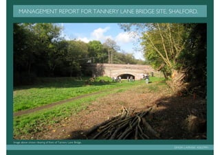
1. MANAGEMENT REPORT FOR TANNERY LANE BRIDGE SITE, SHALFORD.
Image above shows clearing of front of Tannery Lane Bridge.
SIMON LAPINSKI K0637991
2. CONTENTS INTRODUCTION
1 Contents & Introduction This management report is an extension of a previous project we were
assigned in conjunction with the Wey and Arun Trust to create
2 Location proposals to compliment the scheme of re-establishing a section of the
former Wey and Arun Canal at the Tannery Lane site.
3 Physical conditions of site
The idea was to generate a concept utilising the sites assets to develop
4 History a pilot scheme which would attract momentum and funding for future
extensions of the old canal route until finally completing the connection
5 Land-use between the Rivers Wey and Arun.
6 Images of site Of the interventions I submitted I selected the conservation of the
existing Broad-leaf woodland as the basis of my management report in
7 Habitats an attempt to gain a greater depth of understanding as to the feasibilty of
my proposals. With the core of the former project relating to the re-
8 Plant-use introduction of the canal I also took time to examine the possibilities of
its structure and how it may reduce its impact on the surrounding
9 Concept model of proposed interventions Environment.
10 Aims & objectives of management plan The report will illustrate site analysis, design concepts, assessment,
descriptions and processes of reaching the aims of the management plan
11 Conservation of broad-leaf woodland as an introduction to detailing the programmes to be installed to achieve
continued satisfaction of the broad-leaf woodlands for current and future
12 Coppice with standards
users alike.
13 Coppice with standards management plan
14 Coppice with standards management programme
15 Ecological canal bank protection
16 Critical analysis & future predictions
17 Bibliography
CONTENTS & INTRODUCTION PAGE 1
3. LOCATION
Located within the Surrey Hills Area of Natural Outstanding Beauty. The site is directly south of Tannery
Lane Bridge in the Parish of Shalford. The area is accessible by vehicular traffic by country roads via the
A281 Horsham Road to the west. The railway station at Shalford travels between Guildford and Dorking on
the North Downs Line. For pedestrians, cyclists and horse riders the locale is approachable by the Downs
Link which runs through the site and Tannery Lane on the northern border.
OS grid reference TQ000467
Tanyard Lane site, Shalford
Shalford Village
Fig.1 The British Isles inset and County of
Surrey County illustrating location of
Shalford.
Berkshire Heathrow
Staines
.
Weybridge
Camberly
Leatherhead
Tannery Lane study site Guildford
Farnham
. Shalford Oxted
N
Scale 1:10000
Haslemere
Gatwick Sussex
Fig.2 Aerial view of Shalford and proximity to Tannery Lane site. Ref: Google Earth
LOCATION PAGE 2
4. PHYSICAL CONDITIONS OF SITE
TOPOGRAGPY
The site of tannery lane lies within a shallow basin of secondary succession vegetation, gently rising from the bridge eastwards at a gradient of 1:05 per metre.
To the north a former brook has been deepened to accept seasonal floodwaters within an area of Broad-leaf wood which falls down eastwards. To the
south the land rises from 0.7-1.2m wets to east as an embankment that was the location of the former Horsham to Guildford railway Line., falling down to
Cranleigh waters which run parallel.
At the east border of the site, Cranleigh waters crosses from south to west under Gosden aqueduct before turning eastwards and continuing its route.
GEOLOGY AND SOILS
The Shalford area is located on Wealden Greensand, just south of the North Downs. The soils are slightly acidic and free draining.
HYDROLOGY
The region of Shalford is part of the River Wey’s catchment area which flows into the River Thames. The North and South Wey join at Tilford, where the
Wey runs past Shalford to be joined by Cranleigh waters and the River Tillingbourne further north.
PHYSICAL CONDITIONS OF SITE PAGE 3
5. HISTORY OF SITE
From left to right, Tanyard lane road and horse bridge, site of
old tannery, remains of Gosden aqueduct.
•First mentioned in the Doomsday book of
1086 as Scaldefor.
• Agriculture main land-use of area,
producing cereal crops of oats, wheat, barley
and hay.
• Other industries include Tanneries and
Breweries.
• 1816 witnesses construction of Wey and
Arun Canal and Tannery Lane horse bridge.
• 1860, Road bridge built in preparation to
take traffic over proposed railway track.
• 1865, Completed construction of Guildford
to Horsham Railway.
• Local population increases.
Fig. 1 1873 Map of Guildford to Horsham
• 1871 sees closure of Shalford to Guildford Railway through Peamarsh to Bramley and
section of Wey and Arun Canal. Wonerash. Tanyard lane site highlighted.
• 1958 Site becomes part of Surrey Hills
AONB.
LEGEND
• 1965 sees closure of Guildford to Horsham
railway line. Guildford to Horsham
Line
• 1984 old railway route becomes Downs
link connecting North and South Downs. Wey and Arun Canal Ref: Cranleigh railway
HISTORY OF TANYARD LANE SITE PAGE 4
6. LAND-USE OF TANNERY LANE
Farmland
SITE N
Industrial
land and
buildings Tanyard
Lane
Cranleigh
waters
Tanyard Lane
Bridge
Residential
Fig.1 Image of Tanyard horsebridge Fig.2 Fringe of woodland area Horse bridge Brook gardens
from Gosden aqueduct by brook. Educational
buildings
Woodland
Public
open
LEGEND Cranleigh waters space
Educational
and brook
buildings
Secondary
Public open Residential Downs link succession
space dwellings
Secondary Industrial Path
succession buildings
Woodland Industrial Horse and
land footbridge Gosden
aqueduct
Residential Farmland Tannery lane
gardens bridge & Gosden
aqueduct
Downs link Path
LAND-USE OF TANNERY LANE SITE PAGE 5
7. IMAGES OF
RESOURCESSITE
1. Gosden Aqueduct 3. View of site from Tannery Lane Bridge
2. Downs Link Trail
4. View of site from Tannery Bridge Lane 6. Tannery Lane Bridge
5. Cranleigh Waters and weir
IMAGES OF SITE PAGE 6
8. HABITATS e
ridg
Lane B
nery
Within the Tannery Lane site two distinct habitats can be found. The first Tan
which dominates the central section is that of Secondary succession. This
is a result of the original Broad-leafed woodland being cleared to illustrate
the sites potential for a pilot scheme by the Wey and Arun Trust in the re-
introduction of a length of the Wey and Arun canal. The consequence of
the clearance has been the greater penetration of light to the ground layer
and the pre-existing soil resulting in the re-establishment of the plant
community on disturbed land, towards to climax community of the Broad-
leafed woodland.
The existing vegetation is composed in the main by the voracious Urtica
dioca (stinging nettle). Other species found within this habitat and that of
the Broad-leafed woodland are displayed within the plant material section.
The habitat of the broadleaved woodland surrounds the area untouched by Cranleigh
the previous clearance work. The Broad-leafed woodland depicts the waters
climax community which has developed through ecological succession over
time, arriving at a consistent state. The woodland has matured as a product
of the plant community best adapted to the conditions of the region.
It could be argued however that as a Coppice and Standard woodland
which has been continually harvested in the past that it too is a site of
secondary succession.
Fig.1 Lanyard Lane site
before clearance by Wey
and Arun Trust.
LEGEND
Broad-leaf Secondary
Gosden
woodland succession
aqueduct
Ref: Wey & Arun Trust Fig.2 Montage illustrating habitats existing within Tanyard Lane site.
HABITATS PAGE 7
9. PLANT MATERIAL Illustrated here are the main members of the plant community found within the habitats of Tannery Lane site. The
examples of the trees and shrubs are those found within the Broad-leaf woodland and exhibit varieties whose timber is
used in the practice of coppicing (Hazel, Willow and Alder) and those grown as standards (Oak, Beech and Ash). The
annuals and perennials are a selection of the species of plants located within and around the perimeter of the habitat of
secondary succession.
TREES AND SHRUBS ANNUALS AND PERENNIALS
Trees and shrubs: Woody perennials with one or more stems arising from Annuals: Plant that completes its entire life cycle in one year.
the ground. Both can be deciduous or evergreen
Perennial: Plant whose life cycle covers more than two year and does not die
after flowering
Field maple, Acer Ash, Fraxinus Goat willow, Alder, Alnus Stinging nettle, Great Burdock, Mare’s tail, Himalayan balsam,
campestre excelsior salix caprea glutinosa Urtica dioica Artium lappa Equisetum arvense Impatiens granduifera
Hawthorn, Holly, Ilex Hazel, Corylus Ivy, Hedera *Foxglove, *Herb Robert, Grasses, variety of *Ragged robin,
Crategus monogyna aquifolium avellana helix Digitalis purpurea Geranium species Lychnis flos-cuculi
robertanium
* Ref:
Photographs
from River
Wey
&Navigations
Oak, Quercus Sycamore, Acer Bramble, Rubus Walnut, Bindweed, Genus *Common water plantain, *Great Reedmace, *Wild Teasal,
robur pseudoplatanus fruticosus agg Juglens regia Convolvulus Alisma plantago-aquatica Typha latifolia Dipsacus fullonum
PLANT MATERIAL PAGE 8
10. CONCEPT MODEL OF PROPOSED INTERVENTIONS
AIMS:
1. CONSERVATION
OF BROAD-LEAF 1
WOODLAND
1
2. CREATION OF
1
GRASSLAND
MEADOW
2
3. RE- 2
ESTABLISHMENT
OF CANAL ROUTE
3
4. OUTDOOR 2
4
EDUCATION
CENTRE
2
3 2
1
5. ACCESSIBILITY
FOR ALL. 1
1
Fig 1. Plan
elevation of
concept model
for Tannery
Lane Site
CONCEPT MODEL OF PROPOSED INTERVENTIONS PAGE 9
11. AIMS & OBJECTIVES OF MANAGEMENT PLAN
Appraisal, explanations and methods of fulfilling the objectives concerning the management of
conserving the broad-leaf woodland at Tannery Lane will be defined as a precursor to outlining the
work programmes to be prescribed in achieving continued enjoyment of these resources for
current users and a legacy for future generations.
Coup B.
CONSERVATION OF EXISTING BROADLEAVED HABITAT
Aims & Objectives
Coup C.
1. Enhance and maintain habitat of existing broad-leaf woodland.
2. Increase and maintain biodiversity of flora and fauna of habitat.
3. Enable conditions to monitor and combat the effects of climate change.
4. Preserve traditional rural crafts.
5. Sustainable source of timber.
Images of coup divisions within Coup A.
Tannery Lane site. Below Coup D.
AIMS & OBJECTIVES OF MANAGEMENT PLAN PAGE 10
12. CONSERVATION OF BROAD-LEAF WOODLAND
TYPES OF BROAD-LEAF WOODLAND
Britain has different varieties of woodland which has evolved naturally through contrasting soil types, climate, geology and topography. Management and past land-
use will also influence the sort of woodland that matures. In the main woodland is generally classed by the primary tree species growing in that particular wood.
Nevertheless in reality it is unusual to find one specific species of tree prevalent and a wood will include a Varity of tree types.
TANNERY LANE BROAD-LEAF WOODLAND
The broad-leaf woodland at Tannery Lane can be defined as Alder-wet woodland due to the dominance of Alders which prosper on the wet soils. This type of
woodland is typically located along the banks of streams, rivers or wherever poor drainage persists.
The process of succession transforms wetlands into wet woodlands through siltation and evaporation, providing anchorage for tree growth. Alder woodland will
climax to be superceded by Oak woodland as further drying of the soil favours a drier woodland type.
Contractor: Coppice worker harvesting
MANAGEMENT OF BROAD-LEAF WOODLAND
branches. Ref Greenwood centre.
Broad-leaf woodlands are managed for several
purposes. Traditionally it concerned generating the
greatest yield for economically viable products and
game which operates in tandem with our aims of
conservation and increased biodiversity. Indigenous
British woodland was managed to provide a
sustainable source of timber by coppicing woodland
Tree to be Cut close Shoots rapidly Coppice ready
on a rotational cycle. Coppicing utilises the self-
Coppiced. to base in grow from for harvest
regeneration properties of trees by cutting the tree
winter. stool the between 7-20
near to ground level to create a stool from which
Drawing authors own work
following spring. years
branches regenerate at similar thicknesses to be
harvested for the desired needs.
COPPICING
CONSERVATION OF BROADLEAVED WOODLAND PAGE 11
13. COPPICE WITH STANDARDS
Coppice with Standards developed at the time of King Henry IIIV, when he declared an edict that twelve standards or mature uncut trees should be left within each
acre of woodland for timber. The system combines mature standards that occupy the canopy layer creating greater visual continuity to the woodland and a selection
of coppice of different ages and species to provide various types and dimensions of wood for required demand within the under-story. The system also maintains
structural diversity to the under-storey and improved conditions for wildlife conservation. The coppice is managed on a rotational basis varying from 2-20 years again
depending on the variety of tree and demand of wood. The short cycle increases the amount of light penetration reaching the ground layer expanding the level of
biodiversity within the woodland and improving stability of the flora and fauna.
COPPICE WITH STANDARDS
Drawing authors own work
- Canopy
- under-storey
10M - Field layer
- Ground layer
10M
Fig.1 Above Coppice and Standard Broadleaved Woodland of Tannery Lane site. Fig.2 Above Coppicing of woodland at Tannery Lane site.
WOODLAND LAYERS TYPICAL SPECIES
Canopy/Tree layer : The mature trees (standards). Oak, Ash, Beech, Birch
Under-storey/Shrub layer : Consists of younger trees with Field maple, Hawthorn, Hazel,
shrubs adapted to lower light conditions (coppice). Holly, Wild cherry, Alder.
Field layer : Best developed where light penetrates Ferns, Grasses, Sedges,
woodland floor, for example a newly coppiced area. herbs
PRECEDENT: Bradfield Woods, Nr Bury St.Edmunds. National
Ground layer. Mosses, Ivy, Lichens, Fungi Nature Reserve which employed Coppice with Standards
management since1252. Ref: Suffolk Wildlife Trust.
COPPICE WITH STANDARDS PAGE 12
14. COPPICE WITH STANDARDS MANAGEMENT PLAN
THE MANAGEMENT PLAN
The process of coppicing begins each winter,
between the months of November and March
traditionally after the harvest when work on the COUP B
land has slowed down. This season coincides with
the dormant period of deciduous plant life, with
trees shed their leaves to halt the process of
COUP A
photosynthesis and the movement of sap up the
tree to protect its energy reserves and the effects
of frost damage. The reduction of sap content
within the wood also makes it a more efficient
COUP C
source of fuel when most needed.
The wood is divided into a number of coups to
improve the efficiency of managing the woodland.
Depending on the rotational cycle which will could
be between two to twenty years, the coup
COUP D
selected to be coppiced will have its shoots or
poles cut to lengths and stacked in heaps which are
customary known as a cord with each stack being
known as cordwood.
Cranleigh waters
The thinning of standards is required every five
years to reduce the density of canopy and increase
Fig 1. Tree size and density of broad-leaf woodland at Tannery Lane with coup divisions.
the penetration of light to the ground layer. The
selection process involves removing poorly formed, SPECIALIST CONTRACTORS
weak and diseased branches of the trees.
The trade of the Coppice worker has declined sharply since the demand for the by-
In any one coup there will be a number of products from coppice wood has fallen. The craft continues however on a smaller scale
standards of various ages. Up to 40% of the canopy to retain and teach those interested in the traditional skills of the countryside and as a
should be occupied by standards as to many will means of conserving existing woodland under the management of coppicing.
result in poor coppice growth through insufficient
Although originally the work of the Coppice worker or Woodman, the coppicing of
light.
woods can equally be carried out by contracted Arboriculturalists or trained volunteers.
COPPICE WITH STANDARDS MANAGEMENT PLAN PAGE 13
15. COPPICE WITH STANDARDS MANAGEMENT PROGRAMME
The existing broad-leaf woodland at Tannery Lane site covers an area of 9200 m2 or 0.98 Hectares. It takes a Coppice worker 400 man hours to harvest one hectare
of woodland, which with our site would equate 392 man hours. These hours are divided by the number of coup divisions, resulting in 98 man hours per coup on a
yearly rotational basis. With the addition of a trained volunteer to reduce costs the total time required each year to harvest a coup would be 49 man hours or 6.125
days. The estimated cost for these workers would be £1010.65 per year with Coppice worker at £150 per day and volunteer with £15 expenses per day.
Fig.1 Table illustrating Coppice with Standards Management Programme for Tannery Lane Broadleaved woodland
COUP
DIVISION OF BROADLEAVED
A
COUP
WOODLAND
B
COUP
C
COUP
D
THINNING OF
STANDARDS
NOV- NOV- NOV- NOV- NOV- NOV- NOV- NOV-
TASK / MAR
MAR MAR MAR MAR MAR MAR MAR
TIME 2010
2008 2009 2011 2012 2013 2014 2015
TIME
Broadleaved woodland covers 9200 m2 = 0.98 Hectares 392 man/hrs divided by 4 coups = 98 man/hrs = 12.25 days
400 man/hrs to coppice 1 Hectare = 392 man/hrs Each coup to take 1x Coppice worker & one x Volunteer 6.125 days per year
Ref : Lowland landscape design guidelines
COPPICE WITH STANDARDS MANAGEMENT PROGRAMME PAGE 14
16. ECOLOGICAL CANAL BANK PROTECTION
As explained in the opening of the report, it
acts as an extension to proposals developed
CANAL BANK CONSTRUCTION with the Wey and Arun Trust, which centered
on the re-establishment of the former Wey and
Arun Canal. With the constant activity
MARGINAL Native planting experienced at the banks of canals with mooring
SHALLOWS craft, embarking, disembarking crews and erosion
from the swash of passing vessels. The delicate
ecology of the canal is under continuous threat.
BANK AND
200mm x 50mm boards to 1m wide Hoggin towpath
TOWPATH To help secure these habitats I proposed the
protect bank from colliding
installation of stone and timber bank protection
boats and dismounting 2 x 600mm wide x 600mm
as employed by the National Trust at Dapdune
passengers. deep x 500mm high
Wharf, Guildford. The stone gambions were
galvanised steel square
held in place with two rows of round timber
mesh gambions filled with
Canal water level posts which dually served to support timber
regular stone to protect soil
boards acting as barriers against mooring boats
bank from wash generated
and the passage of crew members, so protecting
by passing boats.
the establishing flora and fauna of the marginal
1.4m
shallows and bank.
150mm round poles staked into canal
bed every 500mm. Galvanised steel
square mesh and geo-textile membrane
fixed behind poles to retain soil bank.
NAVIGATION
CHANNEL Authors own drawing
1. NAVIGATIONAL CHANNEL 2. MARGINAL SHALLOWS 3. BANK & TOWPATH
Fish - Bream, Fish - Sticklebacks, Minnows. Mammals - Brown rat.
Tench, Roach, Amphibians - Newts, Frogs. Plants - Birds - Kingfisher.
Birds-dabchick White water lily, Flowering rush, Plants - Bur-reed,
Canal bed
Common reed, Sege, Nettles. Birds - Yellow flag.
Reed-bunting, Reed warbler Fig.1 Image of bank construction at Dapdune
HABITAT CANAL ZONES Drawing authors own work Wharf on River Wey by National Trust.
ECOLOGICAL CANAL BANK PROTECTION PAGE 15
17. CRITICAL ANALYSIS FUTURE PREDICTIONS
The main challenges to the idea of implementing a management Climate change is a result of human activity generating greater
plan to conserve the existing broad-leaf woodland at Tannery Lane concentrations of Carbon dioxide into the atmosphere. Forecasts for
is firstly the availability of funding to continue the vital works Britain indicate higher temperatures, changes in precipitation patterns,
required to initiate the process of restoring a wood which has been greater wind speeds, cloud cover and humidity, all of which will have a
neglected for several decades and maintaining the works to establish direct consequence on the growth structure of trees and their
the benefits of increased biodiversity and an appreciation of this environment.
essential natural resource.
Current Carbon concentrations are not at their optimum for the
Volunteer groups are at the core of forwarding works, displaying process of photosynthesis and with rising levels initial growth increases
tremendous passion and imitative to carry out the works. These are expected. With higher temperatures an extension of the growing
efforts only exist on obtainable funding, of which private donations season will occur which may cause harm through delayed or
are finite. Without the additional assistance from local and national incomplete winter hardening of trees provoking further frost damage.
statutory bodies objectives can become staggered and lethargic with In addition warmer winters might reduce chilling requirements for
the real ambitions always a finger tip away. flowering and seed germination effecting the natural regeneration of
tree species. Lower summer rainfall and increased evaporation rates
Secondly and most importantly is the effects of climate change upon
will lead to extended periods of drought stress on trees making them
the fabric of the broad-leaf woodlands and the strategies that will
more prone to attack from pests and pathogens, while greater rainfall
have to be readdressed and installed to monitor and maintain their
during winter may induce water logging of soils and lower their ability
stability and future prosperity.
to stabilize trees. Higher wind speeds can lead to the increased
severity, unpredictable nature and frequency of storms promoting
greater damage to woodland areas.
Practical responses to the threats posed by climate change cover two
fundamental areas, adaptation and mitigation. Adaptation measures
attempt to minimise the effects of climate change as it progresses and
mitigation responses try to limit the extent of climate change.
The greatest uncertainty however concerning Britain’s broad-leaf
woodlands is the inability to predict the way that human society will
change and in particular how effective its efforts to mitigate climate
change will be.
CRITICAL ANALYSIS & FUTURE AIMS PAGE 16
18. BIBLIOGRAPHY
BOOKS WEBSITES
Nature through the seasons, Richard Adams. www.offwellwoodland&wildlifetrust.org
The Outdoor Classroom, Department of Education and science www.weynavigations.org
Lowland landscape design guidelines, the Forest Authority. www.naturalengland.org.uk
Community woodland design guidelines, the Forestry Commission. www.btcv.org.uk
Forest landscape design guidelines, the Forest Authority. www.weyandarun.co.uk
Along the Riverbank, The Living Countryside. www.Countrysideandguildford.gov.uk
www.naturescape.co.uk
BIBLIOGRAPHY PAGE 17