GIS Open Source Tools and Data Resources
•Descargar como PPT, PDF•
1 recomendación•795 vistas

Talk given to various Public Health professionals in London, December 2013.

Recomendados
Recomendados
Más contenido relacionado
La actualidad más candente
La actualidad más candente (19)
Destacado
Similar a GIS Open Source Tools and Data Resources
Similar a GIS Open Source Tools and Data Resources (20)
Último
Último (20)
GIS Open Source Tools and Data Resources
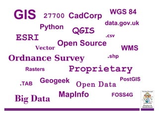
- 1. GIS 27700 CadCorp Python ESRI Vector QGIS .TAB .csv .shp WMS Proprietary Geogeek Big Data data.gov.uk Open Source Ordnance Survey Rasters WGS 84 Open Data MapInfo PostGIS FOSS4G
- 2. Who is this man & why is he here! Name: Simon Miles Job title: GIS Developer Current Employer: Royal Borough of Windsor & Maidenhead Geogeek: YES! Describe your role: I create maps from data, scripts and code; and help 80+ other staff to roughly the same thing! Why are you here: To sell you free GIS!
- 3. Routes into GIS? Astun Technology QGIS Data Open-Source Goodies
- 4. What is QGIS? Open-Source GIS solution = Licence Free <0.5 million downloads as of version 1.8 UK Local Authority uptake growing! www.qgis.org RBWM migrated from a proprietary to open source GIS last year Yr 1 savings of £15,000 in just licence costs Increased our GIS user base to over 80
- 5. Why migrate? ? Spend more with ESRI ? ? Go Open-Source ? ? Alternative GIS vendor ? Image - http://abrampoon.files.wordpress.co/2010/08/at-cross-roads3.jpg ESRI (Proprietary GIS vendor) Costing a fortune Locked in data No real means of scaling up GIS
- 6. Savings? £15,000 in ESRI Licence costs Yr 1 Reduction in Hardware upgrades, Memory, cpu’s etc Server consolidation More GIS for less Further savings in ESRI Licence costs of £7000 Yr 2 Image -http://www.q4.com/savings-accounts/
- 7. What do we do with GIS? Lots! Over 700 datasets in our database Some staff…. Just view data Create data Analysis data
- 8. Data - PostGIS 750 odd GIS datasets From Dog bins to CCTV camera coverage
- 9. Data - Rasters Ordnance Survey supplied data, Vector Map Local 1:50,000 map etc We purchase… Aerial Photography Historic Maps Image:http://clayman5.deviantart.com/art/raster-man-reggae-music-296533472
- 10. Data – Raw GIS formats • Supplied by contractors • Created in-house • Downloads from data.gov.uk ONS Environment Agency Image:http://images.flatworldknowledge.com/campbell/campbell-fig04_008.jpg
- 11. Black & White Bit of 3D Colour Master Map – look and feel
- 12. Master Map – Urban Grain
- 13. 2001 census data
- 14. Crime data
- 15. imd 2010 – Living Environment
- 16. VML + QGIS + Inkscape =
- 17. Me! – Simon Miles simon.miles@rbwm.gov.uk @geosmiles http://ukqgis.wordpress.com/