
Recommended
Recommended
More Related Content
Viewers also liked
Viewers also liked (12)
Similar to Switchyard Park Master Plan | Inventory Phase
Similar to Switchyard Park Master Plan | Inventory Phase (20)
Recently uploaded
Recently uploaded (20)
Switchyard Park Master Plan | Inventory Phase
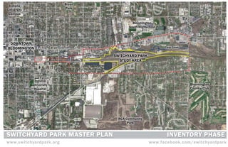
- 1. Indiana Bryan University Park Campus Bloomington South Highschool DOWNTOWN BLOOMINGTON Clear Creek Clear Creek SWITCHYARD PARK STUDY AREA Indiana University Bloomington Hospital Country Club RCA Community Park SWITCHYARD PARK MASTER SWITCHYARD PARK MASTER PLAN PLAN INVENTORY PHASE N 40 20 0 10 0 0 0 www.switchyardpark.org www.facebook.com/switchyardpark
- 2. I N TRODUC TI O N Table of Contents INTRODUCTION Design Team....................................1 Master Planning Process................2 INVENTORY MAPS Study Area........................................8 Tree Inventory.................................27 | Site Photography..............................9 Stream Inventory...........................28 Site Photography............................10 USGS Soil Survey...........................29 Ta b l e Site Photography............................11 USGS Soil Survey Information......30 Figure Ground Study......................12 Environmental Assessment ..........31 Nearby Parks..................................13 Environmental Impacts.................32 Neighborhood Associations...........14 Previous Studies............................33 Historic Districts & Properties.......15 Land Use Themes..........................35 Utilities............................................16 Trade Area Demographics.............36 Sidewalks & Bike Routes...............17 Trade Area 1...................................37 of Thoroughfare Plan.........................18 Trade Area 2...................................38 Transit Routes................................19 Trade Area 3...................................39 Water Bodies & Flood Plain ..........20 Economic Development Areas......40 Conten ts Topographic Model........................21 Existing Land Use Plans................42 Natural Resources.........................22 Growth Policies Plan......................43 Natural Resources.........................23 Zoning............................................44 Habitat Inventory...........................25 Pending Projects............................45 Invasive Species........................... 26 CASE STUDIES Südgelände Nature-Park...............46 Discovery Park...............................46 Circus Square Park........................47 Robert Beutter Park......................47 Common Elements of Success .....486 APPENDIX A | Growth Policy Districts ..........50 A | Growth Policy Districts ..........51 B | Zoning Districts.....................52 B | Zoning Districts.....................55 C | Environmental Studies.........56 C | Environmental Studies.........57 D | Growth Policy Districts.........58 SWITCHYARD PARK MASTER PLAN 1/27/12
- 3. I N TRODUC TI O N PREPARED FOR: CITY OF BLOOMINGTON | Desi gn PROJECT TEAM: R U N D E L L ERNSTBERGER RUNDELL ERNSTERGER ASSOCIATES PROJECT LEAD, LANDSCAPE ARCHITECTURE & URBAN DESIGN ASSOCIATES URBAN DESIGN + LANDSCAPE ARCHITECTURE | www.reasite.com Tea m Butler Fairman and Seufert Civil & Structural Engineering, Hyrdralics & Utilities Eden Collaborative Redevelopment Planning & Implementation Green Street Market Feasiblity & Development Financing Bledsoe Riggert Guerrettaz Survey & Utility Coordination Bruce Carter Associates Environmental Remediation Eco Logic Ecological Analysis & Restoration SWITCHYARD PARK MASTER PLAN 1/27/12 1
- 4. MASTER PLANNING PROCESS Phase One: The Inventory Process • Bicycle & Pedestrian Transportation Plan I N TRODUC TI O N As the initial step in the master plan process, the Switch- • MPO Long Range Transportation Plan yard Park Master Plan team conducted a thorough inven- • 2003 Switchyard/CSX Corridor Master Plan DESIGN PROCESS tory of the site, its surroundings and those factors that • Peak Oil Task Force & Environmental Commission The process involved in the creation of the Master Plan includes four phases of work to be conducted over might influence its development. • Redefining Prosperity: Energy Descent and Commu- nity Resilience the course of eleven months with many opportunities for community involvement and participation. The purpose of the inventory phase was two-fold. First, • Comprehensive Green Space Plan it is essential to understand the physical, environmental, • Environmental Assessments PHASES OF MASTER PLANNING PROCESS ecological, social, economic and development influences • Phase I and II Environmental Site Assessments PHASE ONE | Inventory and Assessment of Existing Conditions | October 2011- January 2012 of the site in order to develop a concept for the park that • B-Line Trail Remediation Completion Report will function efficiently and effectively at each stage of its • Switchyard Phytoremediation Study development and use. • Switchyard Ecological Risk Assessment PHASE TWO | Analysis of Opportunities and Constraints | January - April 2012 Equally important is the need to understand in detail the Stake holder Groups cultural characteristics, history and significance of the site. • City of Bloomington Discovering these distinctive qualities of place and cel- • Utilities Department (CBU) PHASE THREE | Design Charrette for Workshop | May - June 2012 ebrating them through imaginative design will result in a • Utility Providers (Duke Energy and Vectren) community park that is unique to Bloomington. • Transit • Parks and Recreation | PHASE FOUR | Preliminary and Final Master Plan | June - September 2012 During the four-month inventory phase of the master plan, • Planning the project team conducted study area assessments, re- • Schools viewed past studies and current regulations and plans, • Housing Ma s ter and conducted initial interviews with stakeholders. These • Neighborhood Development Included: • Public Works • Economic Development Study Area Assessments • Indiana Department of Environmental Management • Historical • Indiana Department of Natural Resources • Land Use and Zoning • Indiana Brownfield Program • Economic Development Areas • CSX/Arcadis • TIF, CRED, BEAD, Character and Enterprise Zones • Adjacent Business and Housing The information gathered during the inventory phase will Pl a nni n g • Nearby Parks and Greenways enable the team to make informed design decisions as the • Neighborhood Associations master plan moves forward. The project team will explore • Local Interest Areas these inventory findings further in the Analysis Phase of • Utilities the project in order to identify the opportunities and con- • Traffic Patterns straints to park development. This next phase will include • Vehicular, Pedestrian, Transit additional opportunities for stakeholder input as well as • Site Conditions public input. • Soils • Floodway/Hydrology • Topography P r o c e s s • Tree/Invasive Species Inventory • Habitat Existing Studies/Reports/Plans • City of Bloomington • Parks & Recreation Community Interest Survey • Growth Policies Plan • Unified Development Ordinance (Zoning Code) • McDoel Gardens Neighborhood Plan • Broadview Neighborhood Plan • South Rogers Streetscape Identity Study SWITCHYARD PARK MASTER PLAN 1/27/12 2
- 5. Monon Railroad - The Hoosier Line H I S TORI CAL The railroad line associated with the McDoel Switchyard was owned by a series of companies including, initially, the New Albany and Salem Railroad Line. The original company was organized in 1847 by James Brook. Construction of the initial track north from New Albany followed an existing dirt road, and incorporated some of the road’s layout and grades. As a result, the railroad line was built for low speed operation. Over time the line was acquired by other companies, eventually becoming the Monon Railroad and later the CSX Railroad. The railroad line operated almost entirely in Indiana, linking major communities such as New Albany, Bloomington, Lafayette, Indianapolis, and Chicago, as well as numerous smaller communities and six Indiana universities/colleges. The name “Monon” derived from a stream near Bradford Indiana. Potawatomi Indians named the stream “Monong” which means “to carry or swift running.” It is the most familiar name associated with RESE ARCH the railroad line. The rail line transported students to Indiana University in Bloomington, Wabash College in Crawfordsville, DePauw University in Greencastle and Purdue University in Lafayette. Colors for the locomotives and passenger trains were Red & White on Grey for Indiana University, and Gold on Black for Purdue University. However, some accounts attribute the color scheme not to I.U. and Purdue, but to Wabash College and DePauw University, respectively. Those colors were used until the Monon merged with the L & N Railroad. McDoel Switchyard McDoel Yard was one of the largest facilities on the railroad line, second only to the shops in Lafayette, Indiana. Trains working locally out of McDoel trav- eled to Bedford, French Lick, Orleans, Gosport, Ellettsville and to Wallace Junc- | tion to pickup or deliver freight. At its peak, McDoel yards could hold 700 rail cars which served the businesses and industries in Bloomington and other towns along the line. Cars in the yard were sorted and placed in long haul Intr o du c ti o n freight trains and were delivered to Lafayette, Chicago, Indianapolis, Michigan City or Louisville and other destinations. The 105-foot diameter McDoel roundhouse had 17 bays, and a central turntable. It was tunneled with drains. Today the concrete pad that remains has several collapsed drains that may follow the pattern of those found in the 1913 and 1927 Sanborn maps. The roundhouse was surrounded by mechanics shops and a lumberyard, which no longer exist. The neighborhood surrounding the McDoel Switchyard included a mix of residential and commercial business, including the Showers Brothers Company. For many years, the railroad was a major employer in the neighborhood, until the mid-1940’s when the automobile brought about greater mobility. SWITCHYARD PARK MASTER PLAN 1/27/12 3
- 6. 1850 1900 1950 2000 H I S TORI CAL 1847 The New Albany and Salem Railroad, precursor to 1910 McDoel retires in 1909 and the following year the 1956 The railroad nickname “The Monon Route” leads to 2000 CSX Railroad begins to phase out its operations the Monon Railroad, is organized. switchyard is named in his honor. Yard capacity reaches an official corporate name change to the Monon Line 702 cars when a new roundhouse, turntable and water and 2001 City of Bloomington begins discussions to acquire 1853 The NA&S line reaches Bloomington. coal stations are built. 1961 New warehouse is constructed. segments of abandoned rail corridor and the switchyard. 1854 The line inks the Ohio River (to the Great Lakes. 1919 The Showers Brothers Company builds a new kitchen 1967 The last passenger run occurs. 2005 City of Bloomington purchases 3.1 mile of abandoned cabinet factory on the former Dodds farm west of Rogers. rail corridor from Adams Street to Country Club Dr. 1859 The railroad line is reorganized as the Louisville, New 1971 The Monon merges with the L & N Railroad. Albany, and Chicago Railroad. 1923 A new turntable is added to the switchyard. 2008 Ground-breaking for B-Line trail 1976 Dismantling of the switchyard begins. 1892 A ten stall roundhouse is built at the switchyard, cre- 2009 City of Bloomington purchases five switchyard par- RESE ARCH ating a south central Indiana regional hub. cels totaling 27.7 acres. 1897 The line becomes The Chicago, Indianapolis and Lou- 2011 B-Line Trail construction completed. isville Railroad 1899 Controlling interest in the railroad is obtained by J.P. Morgan. W. H. McDoel is named president. | Ti meli n e Nothing remains of the accessory structures,and shops,visible Showers Building, date unknown. Courtesy the Dick Bowen/Tom McDoel roundhouse turntable, 1971. Courtesy Gary Dolzall. The B-Line Trail crosses through the park site. in this early photograph from the Wiles Drug Collection. Rankin Collection Switchyard roundhouse, date unknown. Courtesy Steve Dolzall. McDoel workers at office, circa 1927. Courtesy Tanice Hinson. McDoel Yard office, 1960’s. Courtesy Lloyd J. Kimble B-Line Trailhead at north end of park. SWITCHYARD PARK MASTER PLAN 1/27/12 4
- 7. H I S TORI CAL Roundtable, 1971. Courtesy Gary W. Dolzall McDoel Yard, date unknown. Courtesy of Tom Rankin RESE ARCH Postcard featuring McDoel Switchyard. Courtesy MRTHS McDoel Yard, date unknown. Courtesy of Ron Marquardt | Sources: The following sources were used to obtain the historical Ima ge s information and photographs found herein. Monon Railroad Historical-Technical Society, Inc. http://www.monon.org Bygone Places http://www.monon.monon.org/ Wanatah Historical Society http://www.wanatah.org/railroad.php Switchyard office, circa 1917. Courtesy John Stigall Rick’s Monon Railroad Site http://mononrr.com/ SWITCHYARD PARK MASTER PLAN 1/27/12 5
- 8. H I S TORI CAL SWITCHYARD PARK STUDY AREA RESE ARCH 1949 Aerial | Aer i al P ho to g r a phs SWITCHYARD PARK STUDY AREA 1967 Aerial SWITCHYARD PARK MASTER PLAN 1/27/12 6
- 9. H I S TORI CAL SWITCHYARD PARK STUDY AREA RESE ARCH 1975 Aerial | Aer i al P ho to g r a phs SWITCHYARD PARK STUDY AREA 1998 Aerial SWITCHYARD PARK MASTER PLAN 1/27/12 7
- 10. I N V ENT O RY Indiana Bryan Multi-Family Park Residential Multi-Family University Residential Campus Bloomington South High School Single Family Residential | Commercial Stu dy DOWNTOWN Clear Creek Commercial BLOOMINGTON Switchyard Park Clear Creek (58 Acres) SWITCHYARD PARK Ar ea STUDY AREA Commercial (308 Acres) Single Family Bloomington Indiana Residential Country University Club Hospital Single Family Single Family Residential Residential Cook Pharmica Industrial Multi-Family RCA Community Residential Park N 40 20 0 1 10 0 0 0 SWITCHYARD PARK MASTER PLAN 1/27/12 8
- 11. I N V ENT O RY | Park Site/Downtown are Linked by B-Line Switchyard Trailhead from Bridge B-Line Bridge at Grimes Lane Si te Ph otogr a phy View North of Trailhead and Bridge View South of Switchyard Park from Bridge View SW To Adjacent Commercial Building Clear Creek Runs Along East Edge of Park Informal Trail Adjacent to Clear Creek Park has Several Bridge Remnants SWITCHYARD PARK MASTER PLAN 1/27/12 9
- 12. I N V ENT O RY | Remnants of Track Adjacent to Creek View West Across Park Culverts at Clear Creek Si te Ph otogr a phy Building Remnant/View Across Park Commercial Building Along B-Line East Edge of Park Near Clear Creek Second Rail bed at West Edge of Park B-Line at Southern End of Park View North from Southern End of Park SWITCHYARD PARK MASTER PLAN 1/27/12 10
- 13. I N V ENT O RY | CSX Site at SE Edge of Park View from Park Towards Country Club Dr. Clear Creek/Park Site from Country Club Dr. Si te Ph otogr a phy Retail Area at Country Club Dr./Walnut St. Rogers Street Transit Stop and Housing Residential Housing Typical West of Park View East Across Park from Hillside Drive Walnut Street Commercial Area Bloomington Transit Facility on Grimes Lane SWITCHYARD PARK MASTER PLAN 1/27/12 11
- 14. I N V ENT O RY | F i gu r e SWITCHYARD PARK STUDY AREA G r ou nd Stu dy Industrial N 40 20 0 1 10 0 0 0 SWITCHYARD PARK MASTER PLAN 1/27/12 12
- 15. I N V ENT O RY Bryan Park (33 Acres) Frank Southern Ice Rink | The Waldron, Hill and Buskirk Park - Third Street Park (3.50 Acres) SWITCHYARD Nea r by PARK STUDY Seminary Park (1.2 Acres) (58 Acres Total) AREA Switchyard Park B-Line Corridor (18 Acres) (28 Acres) Pa r ks Rail Corridor (12 Acres) Building and Trades Broadview Park (3.15 Acres) Park (.75 Acres) RCA Community Rose Hill Park Cemetery (47.6 Acres) N 40 20 0 1 10 0 0 0 SWITCHYARD PARK MASTER PLAN 1/27/12 13
- 16. I N V ENT O RY Elm Heights Barclay Gardens Timber Ridge Pinestone Sunny Bryan Slopes Park | Nei gh b or h ood SWITCHYARD PARK STUDY AREA McDoel Broadview Gardens Asso c i a ti o n s Broadview Prospect Evergreen Hill Village Autumn View R Rockport Hills West Pointe Southern Pines N 40 20 0 1 10 0 0 0 SWITCHYARD PARK MASTER PLAN 1/27/12 14
- 17. I N V ENT O RY Old Crescent District Elm Heights Legg House East South Second Dunn Street House Laundry Company Building Andrew Wylie House | Bryan Park Monon Coca-Cola Building Hi s tor i c Railroad Seminary Park SWITCHYARD PARK STUDY AREA Westside Historical District Di s tr i cts McDoel Prospect Hill Steele Dunn & West Side P r o pe r ti e s N 40 20 0 1 10 0 0 0 SWITCHYARD PARK MASTER PLAN 1/27/12 15
- 18. I N V ENT O RY | Uti l i ti es SWITCHYARD PARK STUDY AREA LEGEND SUMMARY Sanitary Utility service to the study area is provided by the City of Bloomington Utilities, Vectren, and Duke Energy. Each has adequate infrastructure to support Water existing conditions and there appears to be sufficient capacity for further development. Storm • The City of Bloomington Utilities has water and sanitary sewer mains paralleling the east and west limits of the switchyard. Hydrants • Duke Energy has overhead lines surrounding the switchyard with several Data crossing the switchyard at Hillside Drive and south of the warehouse across from the Rogers Street substation. Duke indicted that the lines that cross the Gas switchyard can be relocated underground. As we would anticipate, there would be a charge for Duke to perform that work. Electric • Vectren also has natural gas distributed surrounding the switchyard. N 40 20 0 1 10 0 0 0 SWITCHYARD PARK MASTER PLAN 1/27/12 16
- 19. I N V ENT O RY | Si dewa l ks SWITCHYARD PARK STUDY AREA & Bi ke Ro u te s LEGEND SUMMARY The Bloomington Bike, Pedestrian and Bike Lane Routes Greenways Plan is broken into high, medium, and low priority projects. The Trails and Paths high priority planned projects that are within the vicinity of the Switchyard Proposed Bike Lane Routes are “B-line Trail: Central City,” “Walnut Street Bike Lanes,” “Rogers Street Proposed Bike Lane Routes Side-path.” The Plan also includes the near-by medium and low priority Sidewalks projects “Black Lumber Path” and “Rogers Street Sidepath.” N 40 20 0 1 10 0 0 0 SWITCHYARD PARK MASTER PLAN 1/27/12 17
- 20. I N V ENT O RY | Th or ou gh fa r e SWITCHYARD PARK STUDY AREA Pl a n LEGEND SUMMARY The map shows the existing and anticipated roadway thoroughfares within the City. Primary Collector The map designates each roadway as a specific functional classification (e.g. arterial, collector and local street). Primary Arterial Roadways serve two functions: facilitating through traffic movement and providing land access. The functional classification indicates the primary function of a Proposed Secondary Arterial particular roadway. The primary function of higher classified roadways (arterials) is to facilitate through traffic movement while the primary function of lower classified Secondary Arterial roadways (local streets) is to provide land access. The feasibility of a proposed Hillside Drive extension through the Switchyard Park site Secondary Collector is under review and will be analyzed as part of the Park Master Plan. N 40 20 0 1 10 0 0 0 SWITCHYARD PARK MASTER PLAN 1/27/12 18
- 21. I N V ENT O RY | Tr a nsi t SWITCHYARD PARK STUDY Transit Facility AREA Rou tes N 40 20 0 1 10 0 0 0 SWITCHYARD PARK MASTER PLAN 1/27/12 19
- 22. I N V ENT O RY Estimated | Flood Zone 2010 Flood Boundary Estimated Flood Zone Wa ter Clear Creek SWITCHYARD PARK STUDY AREA Bodi es Indiana Watershed Map 2010 Flood Boundary Estimated Flood Zone & Fl o o d Lower East Fork - White River P l a i n N 40 20 0 1 10 0 0 0 SWITCHYARD PARK MASTER PLAN 1/27/12 20
- 23. I N V ENT O RY SWITCHYARD PARK STUDY AREA | Topogr a ph i c LEGEND EGEND 667 - 693’ 745 - 771’ 822 - 850’ 693 - 719’ 771 - 796’ 719 - 745’ 796 - 822’ Elevation Model N 4 4 4 4 4 4 4 4 4 4 4 4 4 4 4 4 4 4 4 40 20 0 10 0 0 0 Model s SWITCHYARD PARK STUDY AREA LEGEND EGEND 0 - 22.5° 112.5 - 157.5° 247.5 - 292.5° 22.5 - 67.5° 157.5 - 202.5° 292.5 - 337.5° 67.5 - 112.5° 202.5 - 247.5° 337.5 - 360° Aspect Model N 40 20 0 1 10 0 0 0 SWITCHYARD PARK MASTER PLAN 1/27/12 21
- 24. NATURAL RESOURCE INVENTORY OVERVIEW Another section of Forested Floodplain is located on more shallow topsoil, and deeper subsoil. Water con- I N V ENT O RY A site assessment was performed to determine the the western side of the B-line Trail, running the en- ditions are the same. state of the natural resources at the Switchyard Prop- tire length of the property with a large section drifting erty. In order to do this, an ecological inventory was out of the property boundary on the southwest end Habitat: Forested Riparian conducted for both the intact and disturbed plant toward the Broadview Neighborhood. Wetland Habi- The forested areas within one hundred feet of Clear communities. This ecological inventory included a tats are located throughout the property with the two Creek are fairly mature and have a higher percent- habitat assessment, an invasive species inventory, a most significant of these habitats being located in the age of native canopy trees than most areas within the tree inventory and stream erosion evaluation. The in- southwestern corner and in the northeast spur which switchyard. These trees are playing an important role vasive species inventory was conducted for the entire goes to Rogers Street directly south of the large ware- in the health of the Clear Creek stream by stabilizing property to catalog on site threats posed to the natu- house. Scrub Shrubs and Trees Habitats are scat- stream banks, and providing shade, both of which im- ral systems. The tree inventory maps all canopy trees tered throughout and Disturbed Open dominates the prove water quality. These trees are also providing over 6 inches in diameter. A stream erosion map was central areas of the property. Specifics for each site habitat for aquatic and terrestrial organisms. Char- created to show the varying levels of streambank ero- are described below. acteristic overstory trees are Catalpa, Silver Maple, sion along the Clear Creek stream. The information Beech, Sycamore, Hackberry, Tulip and Red Maple. gathered during the ecological assessment will aid in Habitat: Forested Floodplain One major threat to the health of the native canopy | understanding both the constraints and the opportu- There are small fragments of floodplain forest through- trees is the proliferation of invasive vines, especially nities inherent with this property. out the Switchyard property which are not in the Clear Japanese Honeysuckle, Oriental Bittersweet, Purple Forested Floodplain Creek corridor. The largest forested floodplain parcel Wintercreeper and Asian Clematis. The land has been highly disturbed, and has experi- is located towards the southwest part of the property Na tu r a l enced much invasive weed pressure, due to the rail and is west of the park boundary in the Broadview The understory shrub layer is dominated by invasive industry and flooding. The greater than a century long neighborhood area. This area has some of the health- shrubs such as Bush Honeysuckle, Privet,and Mult- pattern of disturbance at the Switchyard property has iest forest community on the entire property. The for- filora Rose. The herbaceous understory consists of created an Eden like environment for invasive plants. est overall is again maple-hackberry-sycamore as with several aster and goldenrod species, Indian Tobacco, The invasive plant inventory identified over 25 spe- the riparian areas. Other species such as Sassafras, Boneset, and a variety or grasses and sedges. Black- cies of invasive plants growing in the various habi- Black Walnut, Wild Cherry, and Shagbark Hickory are berry thickets are also present in areas of open can- tats. These invasives range from small herbaceous also found. Invasive plant pressure is somewhat less opy. plants like Garlic Mustard and Spotted Knapweed to here, when compared with the riparian forested ar- a large 60 feet tall Tree of Heaven. There are inva- eas. Both Udorthents loam and Haymond silt loam soils Resou r ce s sive trees, shrubs, groundcovers, broadleaved herbs, are identified on the soil maps. Udorthents have been grasses and vines present. On either side of the gravel trail running north to greatly altered by man and are associated with park- south and parallel to the B-line Trail are ditches, the ing lots, shopping centers, and subdivisions. They There is a healthy stand of native riparian trees run- one on the west is long and narrow, while the area are found in upland disturbed areas and flood plains. ning most of the length of Clear Creek through the between the old trail and the B-line is a low lying wide The water capacity is “moderate and permeability is Switchyard property. In one area, the canopy trees had swale with more consistent moisture. Sensitive fern moderate or moderately slow. Surface runoff is slow been cleared from the banks of Clear Creek, resulting and Christmas fern are established in one area, with to rapid. Organic matter content of the surface layer in a major invasion of Japanese Knotweed which led Blackberry, Black Raspberry and woodland sedges is low. “Haymond silt loam has high water capacity Forested Riparian to major streambank failure. This shows the impor- and grasses (including Silky Rye) grow consistently with moderate permeability. Surface runoff is slow tance of conserving the healthy stand of trees in the through the area. There is one patch of sumac grow- and “organic matter content of the surface layer is riparian corridor. There are also high quality native ing on the very northern end. moderate.” canopy trees located in the floodplain forest and along the old railway towards the west end of the property. This habitat is characterized by two soil types, Crid- Habitat: Wetland There is a fairly high quality floodplain forest towards er-Urbanland Complex, 2-6 percent slopes and Crid- Several wetland habitats are located throughout the the southwest part of the property with mature trees er-Urban land complex, 6 to 12 percent slopes. The site, and vary from open marsh-like wetlands to for- and low levels of invasive plant pressure. Crider-Urbanland Complex, 2-6 percent slopes “con- ested riparian wetlands. The wetlands would be clas- sists of gently sloping, deep, well drained Crider soil sified as low to medium quality with all areas experi- HABITAT INVENTORY and areas of Urban land… The Crider soil in this unit encing considerable invasive plant pressure. Due to Five habitats were determined to comprise the area has high available water capacicty, and permeability adequate hydrology and the presence of hydrophytic within the Switchyards: Forested Floodplain, Forested if moderate. Surface runoff from is medium. The vegetation it is believed that the wetlands do have Riparian, Wetland, Scrub Shrubs and Trees, and Dis- organic content of the surface layer is low…” Crider- high potential for restoration-enhancement, but would turbed Open. The Forested Riparian follows the banks Urban land complex, 6 to 12 percent slopes soil has need a long term strategy for invasive plant control. of Clear Creek with the Forested Floodplain border- similar characteristics as Crider-Urbanland Complex, ing this habitat on the southern half of Clear Creek. 2-6 percent slopes, but has greater slopes, slightly Herbaceous species of interest found in the northern Wetland SWITCHYARD PARK MASTER PLAN 1/27/12 22
- 25. most wetland habitat include Blue Flag Iris, Swamp associated with parking lots, shopping centers, and inhibit any other seeds from germinating. The change I N V ENT O RY Aster, Dark Green Bulrush, Swamp Milkweed, Wool- subdivisions. The water capacity is “moderate and in forest structure that invasive plants cause, can ef- grass, and Soft Stem Bulrush. Red Maple, Green permeability is moderate or moderately slow. Surface fectively eliminate habitat for many plants and ani- Ash, Silver Maple and Cottonwood are the main trees runoff is slow to rapid. Organic matter content of the mals. Most invasive plants are also highly adaptable, found in these wetland habitats. surface layer is low.” which is a cause for great concern with the changing climate. This habitat is characterized by Haymond silt loam INVASIVE SPECIES INVENTORY soils. “The available water capacity of this Haymond The combination of disturbance and heavy weed pres- The inventory was conducted in late fall through early soil is very high, and permeability is moderate. Sur- sure resulting from years of railway activity has cre- winter, and we suspect a few herbaceous species may face runoff from cultivated areas is slow. The organ- ated a haven for invasive plants. The transportation have been dormant. Eco Logic will walk the property ic matter content if the surface layer is moderate.” of seeds and roots on rail cars have brought invasive during the growing season of 2012, and will update These soils are usually very level, deep, well drained, plants from far and wide. the invasive plant inventory if any new species are but are flood prone due to clay content. Thus, these found to be present. areas are not suited for building or development. The inventory finds over 25 species of invasive plants on site, some of which are just starting to become TREE INVENTORY | Habitat: Scrub Shrubs and Trees established in our area. It was no surprise to find • The tree inventory logged all trees in the Switch- There are areas on the northern end and central sec- very common invasive plants such as Bush Honey- yard property over 6 inches in diameter at breast Scrub Shrubs and Trees tion of the property that are Scrub Tree and Shrub suckle, Japanese Honeysuckle and Multiflora Rose height. Habitat. As in the Disturbed Open, non-native spe- all of which have been well established in the Bloom- • Outside of park property, but within the study area Na tu r a l cies dominate including invasive bush honeysuckle, ington area for decades. However, the discovery of only large specimen trees were inventoried. Japanese honeysuckle, and Multiflora Rose. Pampas Grass, Miscanthus Grass and Asian Clema- • total of 1321 trees were inventoried and ranged tis were of more interest, because they are new in- in size from 6” DBH to a 62” Cottonwood Few native understory woody plants have been noted vaders. Sites with industrial disturbance such as the • A total of 22 species of native canopy trees were so far, only Flowering Dogwood and Gray Dogwood. Switchyard are usually the first points of invasion for identified in the inventory. Gray Goldenrod, Aster species, Broomsedge, and new species. Both because the transportation net- • The trees were divided into the following catego- sedges are the main herbaceous native species. work brings in new plants, and the site is disturbed ries by size class. enough to allow them to establish without competi- • 6-10 “ DBH – 316 total trees The Scrub Shrubs and Trees Habitats have Udorth- tion from native species. • 11-15 “ DBH - 512 total trees Resou r ce s ents, loamy soil. Udorthents have been greatly al- • 16 -22” DBH - 382 total trees tered by man and are associated with parking lots, What is an invasive species? • 23- 32” DBH – 96 total trees shopping centers, and subdivisions. The water ca- The official federal definition of an invasive species is, • 33” + DBH – 15 total trees pacity is “moderate and permeability is moderate or “an alien species whose introduction does or is likely • The following data fields were captured for each moderately slow. Surface runoff is slow to rapid. Or- to cause economic or environmental harm or harm to tree on the inventory- ganic matter content of the surface layer is low.” human health.” • Common Name and Scientific Name • Diameter at Breast Height Habitat: Disturbed Open • Invading alien species in the United States • Single Stem or Multi Stem Disturbed Open This is the predominant habitat of the project area and cause major environmental damages and losses • Quality Ranking (high, medium or low) shows the legacy of industrial activity. This habitat adding up to almost $120 billion per year. • Vines – Noting trees which are threatened with is characterized by non-native weedy species such as • here are approximately 50,000 foreign species invasive vines Tall Fescue, Johnson Grass, Queen Anne’s Lace, Spot- and the number is increasing. • The canopy trees were predominately found in ei- ted knapweed, Teasel, Mullein and Chicory. Native • About 42% of the species on the Threatened or ther the Riparian forest or Floodplain forest habitats. herbaceous species include Wild Ryes, Broomsedge, Endangered species lists are at risk primarily be- • In areas where canopy trees were removed from Potentilla, Primrose, a few sedges, white Heath As- cause of alien-invasive species. the banks of Clear Creek, invasive plants pressure is ter, and a patch of Indian hemp on the southern end. high. These areas of clearing are directly correlated Much of the scrub type growth that occurs sporadi- Negative Effects on Ecosystems: with massive stream bank failure. cally throughout the open areas are invasive species Exotic invasive plants can dominate urban forests and • The very limited quantity of hard mast producing such as Siberian Elm, Bush Honeysuckle and Multi- wetlands. Invasive plants alter ecosystem structure trees such as Oak and Hickory, should be addressed flora Rose. A few smaller caliper trees are scattered and function by changing soil chemistry, which can in future restoration planning to increase wildlife hab- lightly throughout including Sycamore, Eastern Red suppress or even extirpate most native competitors itat. Cedar, and Black Walnut. by preventing recruitment. Evidence has shown that invasive plants can alter soil ph, and slow nutrient cy- Udorthents, loamy soil classifies this entire area. cling. Some invasive plants are allelopathic; i.e. they Udorthents have been greatly altered by man and are SWITCHYARD PARK MASTER PLAN 1/27/12 23
- 26. STREAM EROSION INVENTORY The area surrounding the switchyard is dominated by impervious pave- I N V ENT O RY ment, such as rooftops and parking lots, and turf grass, which leads to a greater volume of runoff, velocity and sediment load. The removal of trees from the riparian area has facilitated the invasion of exotic veg- etation. This has dramatically increased stream bank erosion, and sig- nificantly decreased the ability of the riparian area to filter pollutants. The remaining riparian areas are experiencing pressure from invasive species, which will eventually degrade this important habitat so that it will no longer regulate water flow and temperature. Disturbance of the stream corridor and channelization have significantly decreased the quality of the water in clear creek, and the quality of habitat it provides. Protection of existing riparian areas and wetlands, and restoration plan- ning to address loss of habitat is key to the development of an effective stormwater management program and a healthy stream corridor. | Erosion: Low Na tu r a l Resou r ce s Manmade Structure Erosion: Medium Stable Streambank Erosion: High SWITCHYARD PARK MASTER PLAN 1/27/12 24
- 27. I N V ENT O RY | Habit at Inventor y 25 0 1/27/12 20 0 10 50 5 5 5 0 N SWITCHYARD PARK MASTER PLAN
- 28. I N V ENT O RY | Inva si ve Speci es 26 0 1/27/12 20 0 10 50 5 5 5 0 N SWITCHYARD PARK MASTER PLAN
- 29. I N V ENT O RY | Tree Inventor y 27 0 1/27/12 20 0 10 50 5 5 5 0 N SWITCHYARD PARK MASTER PLAN
- 30. I N V ENT O RY | Stream Inventor y 28 0 1/27/12 20 0 10 50 5 5 5 0 N SWITCHYARD PARK MASTER PLAN