Trails Bc Newsletter 2008 01
•
2 recomendaciones•929 vistas

Trails BC Newsletter January 2008 edition

Recomendados
Recomendados
Más contenido relacionado
La actualidad más candente
La actualidad más candente (19)
Último
Último (20)
Trails Bc Newsletter 2008 01
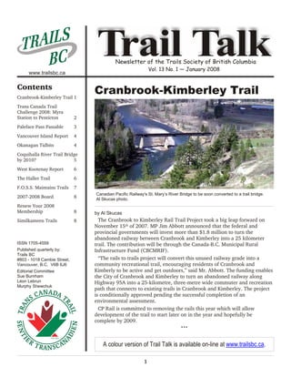
- 1. AI L S TR BC www.trailsbc.ca Trail Talk Newsletter of the Trails Society of British Columbia Vol. 13 No. 1 — January 2008 Contents Cranbrook-Kimberley Trail 1 Cranbrook-Kimberley Trail Trans Canada Trail Challenge 2008: Myra Station to Penticton 2 Paleface Pass Passable 3 Vancouver Island Report 4 Okanagan Tidbits 4 Coquihalla River Trail Bridge by 2010? 5 West Kootenay Report 6 The Haller Trail 6 F.O.S.S. Maintains Trails 7 Canadian Pacific Railway's St. Mary’s River Bridge to be soon converted to a trail bridge. 2007-2008 Board 8 Al Skucas photo. Renew Your 2008 Membership 8 by Al Skucas Similkameen Trails 8 The Cranbrook to Kimberley Rail Trail Project took a big leap forward on November 15th of 2007. MP Jim Abbott announced that the federal and provincial governments will invest more than $1.8 million to turn the abandoned railway between Cranbrook and Kimberley into a 25 kilometer ISSN 1705-4559 trail. The contribution will be through the Canada-B.C. Municipal Rural Published quarterly by: Infrastructure Fund (CBCMRIF). Trails BC #803 - 1018 Cambie Street, “The rails to trails project will convert this unused railway grade into a Vancouver, B.C. V6B 6J6 community recreational trail, encouraging residents of Cranbrook and Editorial Committee Kimberly to be active and get outdoors,” said Mr. Abbott. The funding enables Sue Burnham the City of Cranbrook and Kimberley to turn an abandoned railway along Léon Lebrun Highway 95A into a 25-kilometre, three-metre wide commuter and recreation Murphy Shewchuk path that connects to existing trails in Cranbrook and Kimberley. The project is conditionally approved pending the successful completion of an environmental assessment. CP Rail is committed to removing the rails this year which will allow development of the trail to start later on in the year and hopefully be complete by 2009. ••• A colour version of Trail Talk is available on-line at www.trailsbc.ca. 1
- 2. TCT Challenge 2008: Myra Station to Penticton! Trail Talk: Vol. 13 No. 1 — January 2008 Trans Canada Trail Challenge 2008: Myra Station to Penticton by Léon Lebrun The main or full challenge will be an 80-km Special efforts are being made to bike ride from Myra Station to hold the eighth edition of BC's Penticton. The first 36 km is Trans Canada Trail Challenge in mainly flat and the last 44 km is conjunction with the re-opening almost completely downhill. of the Myra Canyon and the Those who are reasonably fit Penticton Centennial can quite easily do the trip in celebrations. There will not be a less than 6 hours but those that Southwest Region challenge event like to spend time along the way this year in order to allow the planning appreciating the sites and heritage team and volunteers more time to concentrate values can take up to 10 hours. on the Okanagan KVR Challenge. The trip features a rail trail in mountain terrain along with canyons, creeks, cliffs, train trestles/bridges, tunnels, spectacular views, effects of a major forest fire, rock ovens, and vineyards, to name the main attractions. It is a superb trip! Participants will also be given the opportunity to take shorter trips on foot and on bicycle at the Myra Canyon end of the trail. An equestrian component is also Laying down a new deck on Trestle 12. being considered. Murphy Shewchuk photo. It is due to the hard work of our Trails BC Okanagan Directors, the Myra Canyon Restoration Society, the Naramata Woodwackers, the Summerland Trans Canada Trail Society, and the Canadian Ski Patrol that this event is able to take place. Others such as a local amateur radio club and other groups are likely to join in. Those wanting more details and wishing to register for the Challenge event should go to the Trails BC website at www.trailsbc.ca starting mid-February. Because participants need to be shuttled for the full Trestle No. 4 nearing completion in the Myra Canyon. challenge, spaces will be limited. Register early. Photographs courtesy of Katim Enterprises Ltd. ••• It will be held on Sunday, July 6, 2008 following the ACCEPT THE TRAILS BC CHALLENGE official re-opening of the Myra Canyon on June 21st Additional Information and sign-up and 22nd. Some of us will be fortunate enough to take in both events. forms are available on-line at: WWW.TRAILSBC.CA 2
- 3. Paleface Pass... Trail Talk: Vol. 13 No. 1 — January 2008 Paleface Pass Passable by Léon Lebrun adventurous cyclists. Despite the challenges, the In 2005 the BC Ministry of Forests decided to unique West Coast scenery of the rugged sub-alpine decommission the Paleface Forest Road with about 90 pass and the dense rainforest can be rewarding. cross ditches. Most of the ditches were so deep that they were impossible to negotiate with a bicycle and were most unpleasant to walk through. We advised people to not use this portion of the trail, thus seriously impacting the Trans Canada Trail west of Hope. While Bill Kirkness pilots the Kubota excavator, Ray Lebrun operates a landscaping rake. Photo courtesy of Rose Schroeder. Funding received to modify waterbars. After much discussion with the Ministry of Forests or more precisely, their Timber Sales branch, we came to Left to right: Bill Kirkness, partially hidden behind the Kubota an agreement whereby funding was found to allow us excavator, Ray Lebrun and Léon Lebrun. Note the snow on the to modify 80 cross ditches (waterbars) to make them trees in the background. Photo courtesy of Rose Schroeder. passable. The work took place with a small landscape excavator followed by slave volunteers during a four-day stint in October, 2007. About seven of the old waterbars weren’t deep enough to require machine Heavily-loaded cyclists may want to consider work. A bit more hand work will be needed on a few Fraser Valley Roads. ditches on the final approach to the pass. For most heavily-loaded cyclists, a much easier The pass is at an elevation of 4500 feet (1370 unsigned, mainly road route between Hope and metres) and snow was at our heels as the job was Chilliwack is probably the better way to travel. This being completed. alternate route is described in the Trails BC website. ••• Trail to re-open in July, 2008. This work rectified most of the problems and the trail SUPPORT TRAILS BC will reopen soon after the snow clears, which could be MEMBERSHIPS AND DONATIONS CAN as late as the second week in July, 2008. The Paleface NOW BE PROCESSED ON-LINE AT: Pass-Chilliwack River Valley route is one of the WWW.TRAILSBC.CA toughest along the BC TCT and is for the more 3
- 4. Vancouver Island & Okanagan Reports Trail Talk: Vol. 13 No. 1 — January 2008 Vancouver Island Report by Jeannette Klein ‘done deal’, progress has In November 2007, the city of Victoria announced been slowed by a much ambitious plans for a new multiuse waterfront needed review of the pathway from Ogden Point to Rock Bay. This pathway historical value of the will connect with the existing Galloping Goose Trail, Kinsol. In October the part of the TCT system. It is hoped that this could provincial Ministry of become our link to connect the TCT with the Pacific Tourism, Sports and Arts coastline. Heritage Branch The 2006 acquisition of the E & N rail corridor on facilitated a discussion Vancouver Island by the Island Corridor Foundation group to formulate a (ICF) has given new opportunities for rerouting the description of the Kinsol’s TCT from backroads to trails using this right of way. historical significance. If The ICF, a partnership of First Nations and local the Kinsol is officially governments along the E & N line, was created to described as a provincial ensure this rail right of way from Esquimalt to heritage trestle it will be Regional District of Nanaimo Campbell River was not lost and could be used to restored instead of being Parks pedestrian bridge over enhance local communities. Fortunately for the TCT removed and replaced the Top River near Parksville. this includes the concept of rails-with-trails. CVRD with a replica structure. Not on the TCT, but an example of what is happening on the park planners have already identified portions of the For several years the Island. Photo by Jeannette Klein. rail corridor that can be utilized in the Chemainus staff of the Selkirk Station area. Bicycle Rental Shop These initiatives are just 2 of the many trail projects located beside the Galloping Goose Trail has worked at that are happening or being planned on Vancouver the removal of graffiti from the Victoria TCT pavilion, Island. Although many of them are not specifically which has the dubious reputation of being the most Trans Canada Trail they often will connect to the TCT ‘graffitied’ pavilion in Canada. They can now rest easy and indicate the desire for trail systems that is and we thank them. The City of Victoria sign and paint happening Canada wide. shop will take on that responsibility and have already refurbished the pavilion. Although it seemed that the Kinsol Trestle ••• reconstruction project in the Cowichan Valley was a Okanagan Tidbits by Ben Veldhoen using the railway grade to access the development There were two severe weather events in the land. No one has the legal authority to stop the traffic. Okanagan late in 2007. Heavy rains in early fall caused Conflict between recreational user groups was a washout at Robinson Creek. It was repaired. Later in mitigated by offering bottled water provided by the 2007 a major windstorm left plenty of blowdown on Naramata Parks and Recreation Commission at the the right-of-way at higher elevations. A few of the remote Woodwacker camp near Rock Oven Regional majestic old growth Ponderosa pines bit the dust. Park. Everybody seems to drink and appreciate the Shades of things to come? same water! Greater than normal snowfall so far this winter make After the 2003 Okanagan Mountain fire and the for perfect cross country skiing particularly at Chute burning of the Myra Canyon trestles, traffic on the Lake. Washrooms along the trail are being maintained. Trans-Canada Trail from the east has dwindled to a Preservation of the trail for recreational purposes trickle. We are expecting an influx of users, starting continues to be a challenge. Above Naramata, near the with the Trans-Canada Trail Challenge in early July. Arawana station site, a major residential subdivision is ••• being developed. Heavy construction equipment is 4
- 5. Coquihalla River Bridge Trail Talk: Vol. 13 No. 1 — January 2008 Coquihalla River Trail Bridge by 2010? by Léon Lebrun The Coquihalla Trail Bridge is a major project to be located on the Trans Canada Trail 21 km northeast from the Hope town centre where the trail crosses the Coquihalla River. It is within a narrow corridor shared by Highway #5, two pipelines, a fibre optic cable, and a power line. The location allows for a bridge structure that will not encroach on any of these properties. It is up river on crown land adjacent to these right-of-ways and more specifically along the Spectra Energy gas pipeline. This differs slightly to the location of a previous service road bridge that The site of the proposed trail bridge across the Coquihalla River. Photo by Léon Lebrun. was washed away in 1995 resulting in a considerable widening of the river, and was partially located in the routing leads the user to this location thus creating Spectra Energy pipeline right-of-way. The proposed possible high risks. In other words, the TCT is bridge will be located slightly further up river to stay effectively severed for 7.5 km. and the existing clear of Hydro lines and the Spectra Energy pipeline alternatives pose serious danger. right-of-way. With a bridge, the much improved routing will attract The Trans Canada Trail generally parallels Highway many more trail users because they will see this as a #5 and needs to accommodate cyclists, walkers, and legitimate continuation of the Kettle Valley Rail equestrians. Currently, without the proposed bridge, Corridor to Hope via the famous Othello Tunnels on walkers and equestrians along this portion of the Trans the former KVR. Other features include mountain Canada Trail are forced to ford the Coquihalla River. It views, the highly picturesque Coquihalla River, and is not advisable to cross the river at any time because it wilderness camping. Yet, it is only 20 km from the is either quite dangerous or impossible for much of the historical town of Hope where all needed amenities year due to high volume flow, fast current, and coarse can be found. bottom. Due to a number of challenges, Don Reid, one of our Cyclists are allowed and are forced on the highway to volunteers, has come up with a design that no longer avoid the river ford for 7.5 km when travelling west or will be using the suspension bridge that we had for 4.5 km when travelling east. A centre line concrete announced about a year ago. Following final barrier and high speed vehicular traffic prevents approvals, hopefully, we will be able to start crossing the highway thus creating the different construction by early 2009 if not before. Of course, this distances going east as opposed to west. Riding on the is dependent on our ability to raise the required shoulder of Highway 5 is uncomfortable and unsafe for $270,000 to build such a structure. even the seasoned cyclists because the 110 km/hr ••• speed limit that is commonly exceeded. The lack of a bridge at this location creates a risky dilemma for Trans Canada Trail users because neither SUPPORT TRAILS BC of the choices of staying on the highway or attempting MEMBERSHIPS AND DONATIONS CAN NOW BE to ford the river is desirable or safe. Unfortunately, our PROCESSED ON-LINE AT: WWW.TRAILSBC.CA 5
- 6. West Kootenay Report / The Haller Trail Trail Talk: Vol. 13 No. 1 — January 2008 West Kootenay Report by Sue Burnham very rough. It is recommended that those travelling Thanks to the efforts of members Columbia and with loaded bicycles use the highway to travel from Western Trail Society and Trails BC, the Rail/Trail Castlegar to Trail. immediately north of Castlegar was raked and New panel added to TCT Pavilion… groomed early in the season,making the Trail safer and Citizens of the Trail area have been very supportive easier to travel. The C+W members continued to work of the TCTF Metre Sales Programme and a new panel on the Trail all summer, keeping up with the of names has recently been added to the TCT pavilion grooming, weeding and culvert clearing needed to at Gyro Park. In the Pend D’Oreille region, south and keep the Rail/Trail in good condition. Still in the east of the city of Trail, the TCT was under siege from Castlegar area, there is good news from the Brilliant summer forest fires. The Trail survived, but was closed Bridge Restoration Society who have recently received for several weeks as fire-fighters were using the route a $150,000 grant from the Central Kootenay RD to to reach the fire zone. help with the cost of restoring this historic Kootenay River crossing. The Ministry of Transportation has also Good news in Salmo/Nelson area… helped by providing the Society with the money it There is more good news to report in the would have taken to have the bridge removed. Plans Salmo/Nelson area. All stakeholders have agreed to are to have the bridge re-surfaced by the summer of having the Great Northern Rail/Trail included in the 2008. Trans Canada Trail system. Travelers will then connect Trail between Ootischenia and Trail rough… with the highway and ferry to reach Gray Creek Pass, the route to the East Kootenays. Work continues on the Columbia Trail between ••• Ootischenia and the city of Trail, but this stretch is still The Haller Trail by Larri Woodrow For the past twelve years, Trails BC horsemen have partnered with Back Country Horsemen of BC members to keep a little known, cherished Cariboo horse trail clear of windfalls. Twenty four horsemen from various points of the province attended the May 2007 workbee and ride. Riders hauled their horses and mules from Lillooet, Quesnel, 100 Mile, Langley, Courtenay, Merville and Black Creek to the trailhead near Jesmond, west of Clinton. In his journal, Simon Fraser and his men reported seeing natives mounted on their horses near this area Larri Woodrow (left) with John Hawkings and Larri's mule, as he and his men made their epic journey of discovery Appalouie, at Eddy's Lookout on the Haller Trail high above the downstream for the North West Company in 1808. Fraser River. Photo by Hank McEwan. This year, during Canada's Equine Week, when on an end of May workbee on the Haller Trail, recreational Eddy Grinder was a native horseman who rode trails horsemen will celebrate the 200th anniversary of and hunted this area. On a chilly October night my Fraser's accomplishment. trail partner and I over-nighted with Eddy and his two Trails BC has always been intended to be an sons. My partner and I had intended to pitch our tent organization to embrace all provincial trails. The nearby, but Eddy insisted we join him in his woodstove Haller is one such example. Murphy and Katharine warmed cabin. With the thermometer plunging, his Shewchuk have ridden it when Murphy GPSed a good offer was too good to refuse. part of it a few years ago. ••• 6
- 7. Friends of the South Slopes Trail Talk: Vol. 13 No. 1 — January 2008 F.O.S.S. Maintains Trails by Penny Gubbels · Erosion mitigation projects on trails. · Trail improvement and maintenance. · Adopt-A-Trail program. · Produced a trail map of Myra-Bellevue (available at most outdoor stores in Kelowna). F.O.S.S. has a signed Volunteer Agreement with BC Parks and works in partnership with Ministry staff. July 2007: FOSS volunteers build a section of trail through Kelowna's Priest Creek Linear Park (the trail provides public access to Myra-Bellevue Provincial Park). Photo by Teresa Brinton. The Kelowna-based Friends of the South Slopes (F.O.S.S.) is a non-profit Society formed in 1996. It is a volunteer organization with no paid staff. Its area of interest is Kelowna’s South Slopes which includes a section of the Trans Canada Trail along the old Kettle Valley Railway line, two provincial parks (Myra-Bellevue and Okanagan Mountain), and trails on Crown land. F.O.S.S. supports projects that enhance recreational opportunities while respecting the natural environment. The South Slopes is widely known for its April 2007: Volunteers clear brush prior to the construction of extensive trail system and it is a popular mountain Priest Creek Trail. Photo by Penny Gubbels. biking, hiking and horse back riding area. Many of the South Slope trails were severely impacted by the 2003 As well, F.O.S.S. has coordinated trail clearing Okanagan Mountain Provincial Park forest fire and projects on Crown land in the Joe Rich/Mission Creek F.O.S.S. has undertaken many projects to restore trails area of the South Slopes, and plan to erect signage in and bridges. 2008. In Myra-Bellevue Park, these projects include: Friends of the South Slopes support the inclusion of · Partnered with BC Parks to construct a trailhead public access to the South Slopes when adjacent and parking lot. private properties are developed. F.O.S.S. partners · Built an information kiosk. with the City of Kelowna Parks Department to construct and maintain these access trails. · Purchased and installed trail and information signs and ‘you are here’ maps throughout the park. For more information, please visit the F.O.S.S. website: www.foss-kelowna.org or contact the · Constructed foot bridges and boardwalks (in Secretary at: info@foss-kelowna.org Okanagan Mtn. Park as well). ••• 7
- 8. Back to Business Trail Talk: Vol. 13 No. 1 — January 2008 Renew Your 2008 Membership As we begin another year of work on the British Columbia portion of the Trans Canada Trail, we ask for your continued support and membership renewal. Individual: $25 Group Member: $100 Business Associate: $100 Payment may be made by sending a cheque to the office or by paying on-line at www.trailsbc.ca. Tax receipts will be issued for individual membership payments (as well as all donations). As you will read in the newsletter, there is progress being made in each of the regions across the province. Our dedicated volunteers continue to work with individual citizens, TBC member groups, local businesses and all three levels of Government in order to reach the goal of having the B.C. Trans Canada Trail navigable from Victoria to the Alberta border by 2010. We can’t do it without you! 2007-2008 Board President: Regional Directors: Rockies/East Kootenay: Gordon Weetman T.B.A. Vancouver Island: Al Skucas Larri Woodrow Vice President: Jeannette Klein Northeast: Léon Lebrun Jack Gladysz Provincial Office: Southwest: Treasurer: Léon Lebrun Trails BC Jack Harder Directors-at-Large: #803 - 1018 Cambie Street, Okanagan: Secretary: Ben Veldhoen Jack Harder Vancouver, B.C. V6B 6J6 Sue Burnham Boundary: Kelly Koome Tannis Killough Trevor Lind Tel: (604) 737 3188 West Kootenay: George Longden Email: trailsbc@trailsbc.ca Sue Burnham Murphy Shewchuk Web Site: www.trailsbc.ca Similkameen Trails by Joe Littlefield Red Bridge and to Our quest is to establish a chain of trails linking all Kobau Park in communities through the Similkameen Valley from Cawston. The Manning park to the U.S. border and east to Osoyoos. Promenade This would create an addition to the successful RDOS volunteers are trail system and bring new leisure and business fundraising in opportunities to the Similkameen Valley. order to complete We will work to rededicate traditional trails that the project. This follow the river and provide a historical reference that project is a joint venture between the Village and the connects First Nations with new Canadians. Trails Society. We expect to achieve this by encouraging Trail sections from the Red Bridge to Kobau Park neighborhoods to establish safe walking and biking were surveyed by local Trail Scouts who noted items circuits within their communities; then we can link and issues along the abandoned railbed and the dike. communities with trails. This information is part of the RDOS district-wide trail inventory assembled to manage and budget for trails. This is being tested with the Keremeos Village Contact similkameentrails@nethop.net for more Promenade, a walking and wheelchair circuit, over the information. old rail bed and the dike; with proposed links to the ••• 8