

Recomendados
Recomendados
Más contenido relacionado
La actualidad más candente
La actualidad más candente (20)
Destacado
Similar a Geographic Information Systems in Archaeological Survey
Similar a Geographic Information Systems in Archaeological Survey (20)
Más de Tim Weitzel
Más de Tim Weitzel (13)
Geographic Information Systems in Archaeological Survey
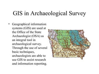
- 1. GIS in Archaeological Survey • Geographical information systems (GIS) are used at the Office of the State Archaeologist (OSA) as an integral tool in archaeological survey. Through the use of several basic techniques, archaeologists are able to use GIS to assist research and information reporting.
- 2. Decision Support GIS Data are consulted as part of initial background research for conducting the field portion of a contract survey. This information serves as critical reference material to assist development of cost-effective, resource sensitive survey strategies. Data layers considered while developing a survey strategy include the locations of previously recorded sites, soil types, landform context, parent material, and slope gradient. Additional layers may be considered as needed. The same information provides geospatial and temporal context information to assist description of cultural materials found in the course of an archaeological project.
- 3. • For instance, The distance and location of previously recorded sites are considered in relation to the project area. The project area shape file, shown here as a square, is intersected with the shape file containing the site location and boundary information.
- 4. • In this example, various data layers, such as landscape position and slope gradient, provide important information regarding the potential for below-plow zone sites in a upland context from southern Iowa. The use of thoughtfully chosen fill patterns can help elucidate this potential in an easy to perceive, graphical context.
- 5. Reporting Information • Recording field data, such • Site information is stored as the location, extent, the in a relational database type and results of format that is associated archaeological testing is with the GIS by site assisted through the use of number. a project GIS. Newly • Project results are discovered archaeological recorded in a statewide site boundaries and cultural resources survey locations are reported in coverage GIS at the State shape file format. Historical Society of Iowa.
- 6. Data Warehouse • The resulting resource survey coverage databases in turn become part of the permanent record of archaeological information Coverage for the state of Iowa • Archaeological survey Results information is now ready for use by any archaeologist anywhere in Locations the state