
Recomendados
Recomendados
Más contenido relacionado
Destacado
Destacado (20)
Más de West Hollow MS Ms. Gill
Más de West Hollow MS Ms. Gill (20)
Ocean Basins Worksheet
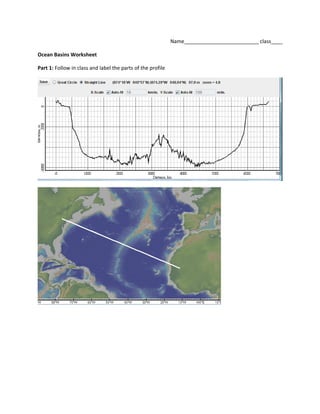
- 1. Name__________________________ class____ Ocean Basins Worksheet Part 1: Follow in class and label the parts of the profile
- 5. Part 2: The 3 maps below refer to the profiles on the following pages. First you must determine which map matches which profile. Label both the map and the profiles with the following labels. First start by drawing a line at sea level. South America- label the Pacific Ocean, Atlantic Ocean, Andes mountains, continental shelf, continental slope, abyssal plain Alaska- label continental shelf, island (volcanic), ocean trench, Pacific Ocean, abyssal plain This profile includes the Bering Sea. Do you think that the profiled section of the Bering Sea is made of Continental Crust or Oceanic Crust? ________________________ Asia and Japan- label Asia, Japan, ocean trench, Sea of Japan, Pacific Ocean. Which sea/ocean is deeper?_______________