Ugko ad obst & radio nav & landing aids updates
- 1. AD 2.UGKO-4 AIP Georgia
07/03/2013~~~eaip-amdt~~~airac012013
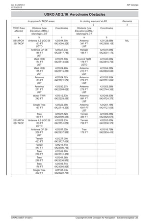
UGKO AD 2.10 Aerodrome Obstacles
In approach/ TKOF areas In circling area and at AD Remarks
1 2 3
RWY/ Area Obstacle type Coordinates Obstacle type Coordinates
affected Elevation (AMSL) Elevation (AMSL)
Markings/ LGT Markings/ LGT
a b c a b
08/ APCH Antenna ILS LOC 08 421044.90N Antenna 421128.68N NIL
26/ TKOF 163 FT 0423004.52E 341 FT 0422958.10E
LGTD LGT
Antenna GP 08 421027.63N Hangar 421031.65N
186 FT 0422817.78E 185 FT 0423001.17E
LGT
Mast NDB 421026.80N Control TWR 421040.66N
174 FT 0422714.69E 178 FT 0422815.79E
LGT LGTD
Mast NDB 421024.40N Antenna 421054.28N
175 FT 0422715.25E 213 FT 0422802.04E
LGT LGT
Antenna 421024.52N Antenna 421055.51N
153 FT 0422721.55E 278 FT 0422751.69E
LGT LGT
Antenna 421030.27N Antenna 421053.56N
271 FT 0422309.62E 278 FT 0422744.38E
LGT LGT
Water TWR 421012.63N Antenna 421249.53N
242 FT 0422229.58E 991 FT 0424724.37E
LGT
Single Tree 421023.99N Antenna 421251.18N
167 FT 0422719.33E 1097 FT 0424727.55E
LGT
Tree 421027.52N Terrain 421309.28N
159 FT 0422706.56E 384 FT 0423425.67E
26/ APCH Antenna ILS LOC 26 421028.23N Terrain 420552.65N
08/ TKOF 130 FT 0422751.05E 738 FT 0422536.37E
LGTD
Antenna GP 26 421037.65N Tree 421016.79N
206 FT 0422937.97E 176 FT 0422834.41E
LGT
Terrain 421227.09N
423 FT 0423727.86E
Terrain 421216.54N
417 FT 0423706.76E
Tree 421049.86N
256 FT 0423131.41E
Tree 421041.26N
218 FT 0423036.97E
Tree 421046.74N
176 FT 0423005.99E
Single Tree 421101.03N
302 FT 0423222.73E
.
AIRAC AMDT 01/2013 Copyright © 2013 Georgian Air Navigation - Sakaeronavigatsia Ltd.
- 2. AIP Georgia AD 2.UGKO-5
07/03/2013
~~~eaip-amdt~~~airac012013
UGKO AD 2.11 Meteorological information provided
1 Associated MET Office KUTAISI
2 Hours of service H24
MET Office outside hours –
3 Office responsible for TAF preparation KUTAISI
Periods of validity 9 HR
4 Trend forecast TREND
Interval of issuance 0.5 HR
5 Briefing / consultation provided Personal consultation and telephone consultation
6 Flight documentation Charts, tabular form, abbreviated plain language text
Language(s) used English
7 Charts and other information available for briefing or S, U85, U70, U50, U30, U20, P85, P70, P50, P40, P30, P20,
consultation SWH, SWM, T
8 Supplementary equipment available for providing NIL
information
9 ATS units provided with information Kutaisi TWR; Tbilisi TWR, APP1, APP2, APP3, ACC
10 Additional information (limitation of service, etc) NIL
UGKO AD 2.12 Runway physical characteristics
Designations True Dimensions Strength (PCN) THR coordinates THR elevation and highest
RWY BRG of RWY (M) and surface of RWY end elevation of TDZ of precision
NR RWY and SWY coordinates APP RWY
THR geoid
undulation
1 2 3 4 5 6
08 080.28º 2500 x 44 PCN 50/R/C/X/T 421029.85 N THR 133 FT
Concrete 0422804.01 E
—
GUND 61.4 FT
26 260.29º 2500 x 44 PCN 50/R/C/X/T 421043.28 N THR 160 FT
Concrete 0422951.51 E
—
GUND 61.4 FT
Slope of SWY CWY Strip OFZ Remarks
RWY-SWY dimensions (M) dimensions (M) dimensions (M)
7 8 9 10 11 12
0.32% NIL 400 x 150 2620 x 150 NIL NIL
0.32% NIL 400 x 150 2620 x 150 NIL NIL
UGKO AD 2.13 Declared distances
RWY Designator TORA (M) TODA (M) ASDA (M) LDA (M) Remarks
1 2 3 4 5 6
08 2500 2900 2500 2500 NIL
26 2500 2900 2500 2500 NIL
Copyright © 2013 Georgian Air Navigation - Sakaeronavigatsia Ltd. AIRAC AMDT 01/2013
- 3. AIP Georgia AD 2.UGKO-7
07/03/2013
~~~eaip-amdt~~~airac012013
UGKO AD 2.18 Air traffic services communication facilities
Service designator Call sign Frequency Hours of operation Remarks
1 2 3 4 5
APP2 Kutaisi Approach 127.100 MHZ H24
TWR Kutaisi Tower 125.500 MHZ H24
UGKO AD 2.19 Radio navigation and landing aids
Type of aid, ID Frequency Hours of Position of Elevation of DME Remarks
MAG VAR operation transmitting antenna transmitting
CAT of ILS/MLS coordinates antenna
(For VOR/ ILS/
MLS give declination)
1 2 3 4 5 6 7
DVOR/DME KTS 113.600 MHZ H24 421032.6N 200 FT
(6ºE/2012) (CH 83X) 0422905.3E
NDB TIG 477 KHZ H24 421025.6N
(5ºE/1995) 0422714.9E
LOC 08 IKS 110.100 MHZ H24 421044.9N
(6ºE/2012) 0423004.4E
ILS CAT I
GP 08 — 334.400 MHZ H24 421027.6N
0422817.8E
DME 08 IKS CH 38X H24 421027.6N 133 FT Omnidirectional
0422817.8E Coverage
range up to
25 NM
LOC 26 IKO 108.700 MHZ H24 421028.2N
(6ºE/2012) 0422751.1E
ILS CAT I
GP 26 — 330.500 MHZ H24 421037.6N
0422938.0E
DME 26 IKO CH 24X H24 421037.6N 153 FT Omnidirectional
0422938.0E Coverage
range up to
25 NM
UGKO AD 2.20 Local traffic regulations
1 Airport regulations
At Kutaisi/Kopitnari airport a number of local regulations apply. The regulations are collected in a manual which is available
at the AIS Briefing Office.
2 Taxiing to and from stands
Arriving aircraft will be allocated a stand number by the TWR.General aviation aircraft will have to use the general aviation
parking area.
Assistance from the "FOLLOW ME" vehicle can be:
• requested via the TWR;
• available when visibility is less then 400 M;
• available during night time for C and D categories aircraft.
Departing IFR and VFR flights shall contact TWR to obtain ATC clearance before commencing taxing. Request for ATC
clearance may take place at earliest 10 minutes prior to engine start–up.
After pre–flight preparation, decision to take–off and receiving of ATC clearance for the flight, the pilot–in–command of an
aircraft makes a decision whether or not to take off from the aerodrome, fly along the airway and land at the destination
aerodrome, and is entirely responsible for the decision taken.
Copyright © 2013 Georgian Air Navigation - Sakaeronavigatsia Ltd. AIRAC AMDT 01/2013