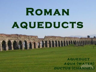
2. Aqueducts
The purpose of this project is to provide some
information about Roman aqueducts. But first
of all, what is an aqueduct?
An aqueduct is a water supply or navigable channel
constructed to convey water. The main purpose of an
aqueduct is to transport water to a city so that it can be
used from the local population
3. Aqueducts before the Romans
Before the Romans, many other people had used
aqueducts, e.g. the Egyptians, the Indians, the
Assyrians, the Aztecs, the Persians and the
Greeks.
These aqueducts however, were very simple
constructions and for this reason, they cannot be
compared with the Roman aqueducts.
8. Aqua Appia
The first Roman aqueduct was Aqua Appia, built in
312 B.C. by Appius Claudius Caecus.
The aqueduct flowed for 14,6 km into the city of Rome
through the Porta Maggiore and emptied into the
Forum Boarium.
Nearly all of its length was underground for two main
reasons:
1) it was necessary due to the relative height of its
source and destination
2) it should be protected from the Samnites, who
were at war with Rome at that time.
It dropped only 10 m over its entire height, which
made it a great achievement for that time.
11. Segovia
1.The aqueduct of Segovia is definitely one of the best
Roman aqueducts in Spain. It was built in Vacceos, a densly
populated area before the Roman occupation.
The date of its construction is unknown because the aqueduct
lacks a legible description but researchers believe that it was
built between the second half of the 1st century A.D. and the
early years of the 2nd century, which means during the reign
of Vespasian or Nerva.
Its purpose was to transport water from a river called Fuente
Fria to the city of Sergovia, which is a 32 km distance. The
water gathered at a tank known as El Caseron at first. Then, it
was led to a second towel through a channel. There it was
naturally decanted and sand settled out before the water
continued its route. After that, the water flowed on a 1% grade
until it reached a rocky outcropping. Finally, it made an abrupt
turn and headed toward Plaza Azoguejo.
13. Segovia
The aqueduct was build of unmortared, brick-like granite
blocks. During the Roman period the 3 tallest arches
displayed a sign in bronze letters which indicated the name of
the builder and the date of its construction.
Only two nitches are still visible today. The total number of
arches that the aqueduct has is 75 single arches and 44
double arches. The first section of the aqueduct contains 36
arches, organized in two levels which are decorated simply.
The pillars of the upper level are narrower and shorter than
those of the lower level. However, their total width (5,1m) is
bigger than the width of those on the lower level (4.5m).
Moreover, the pillars gradually increase in circumference size.
The lower pillars have a cross section measuring 1.8-2.5m
while the upper pillars have a cross section measuring 2.4-
3m.
The whole structure is supported by moulds that hold the
frame and on top of the structure water travelled through a
channel. The aqueduct reaches the height of 28.5 m.
15. Segovia
In 1072 a part it was destroyed by the Moors but
in the 15th century, it was reconstructed by the
king Ferdinand.
In the 16th century the central niches were placed
on the structure.
Nowadays, this aqueduct is Segovia's most
famous landmark preserved in a relatively good
condition.
In 2006, it was listed in the World Monuments
Watch because of differential decay of stone
blocks, water leakage from the upper viaduct and
pollution.
18. Aqueduct of Mérida, Emerita Augusta
The Acueducto de los Milagros is a ruined Roman
aqueduct in Mérida, Spain, formerly the Roman
colony of Emerita Augusta
Only a relatively small stretch of the aqueduct still
stands, consisting of 38 arched pillars standing
25 metres high along a course of some 830 metres . It is
constructed from opus mixtum utilising a double arcade
arrangement. The structure originally brought water to
the city from a reservoir called the Lago de Proserpina,
fed by a stream called Las Pardillas, around 5 km to the
north-west of Mérida.
It is thought to have been constructed during the 1st
century AD, with a second phase of building (or
renovations) around 300 AD.
The aqueduct is preserved as part of the Archaeological
Ensemble of Mérida, a UNESCO World Heritage Site.
22. Aqueduct of Tarragona, (Tarraco)
The Aqueducte de les Ferreres (also known as Pont
del Diable in Catalan, English: Devil's Bridge) is
a Roman aqueduct in Catalonia, Spain built to supply
water to the ancient city of Tarraco. The aqueduct is
located 4 kilometers north of Tarragona, in
the Autonomous Community of Catalonia. The
aqueduct is part of the Archaeological Ensemble of
Tárraco, which was added to the UNESCO's list of World
Heritage Sites in 2000.
23. Aqueduct of Tarragona
The aqueduct took water from the Francolí river, 15
kilometers north of Tarragona. It probably dates from the
time of Augustus. The aqueduct has a maximum height
of 27 m and a length of 249 m, including the ends where
the specus (water channel) runs atop a wall. It is
composed of two levels of arches: the upper section has
25 arches, and the lower one has 11. All arches have the
same diameter of 20 Roman feet (5.9m) with a variation
of 15 cm. The distance between centres of the pillars is
26 Roman feet (7.95m).
29. Pont du Gard
1.The Pont Du Gard is an aqueduct bridge that crosses the
Gard river in southern France.
It is part of a 50 km long aqueduct that was built in the first
century A.D. near the city of Nimes, which had a population of
50.000.
The aqueduct carried water from its source at Ucetia to
Nimes, where it was used at fountains and baths. It is
estimated that about 27 hours were needed to carry the water
and that 200.000.000 litres were carried each day.
Some historians believe that Agrippa, Augustus' son in law
ordered the construction in 19 A.D. Others believe that it was
constructed between 40 and 60 during Claudius' reign.
It is estimated that 15 years of hard work was needed and
that more than 1000 workers took part in the construction.
The estimated cost is more than 30.000.000 sestertii!
30. Pont du Gard
2.The Pont Du Gard was build at a period that Roman aqueduct
technology was not fully developed. Its design's technique of
stacking arches on top of each other is expensive as it requires a lot
of stone. The architect is unknown.
The rout was planned by a surveyor using chorobates for levelling,
gnoma for sighting and a set of measuring poles ten feet long. The
architect would have recorded figures and perhaps drawn plans on
wax tablets, later to be written up on scrolls. The builders may have
used templates to guide them with tasks that required a high degree
of precision, such as carving the standardised blocks from which the
water conduit was constructed. They also used cranes and block
and tackle pulleys to lift the stones. For ordinary blocks, sheers
operated by a windlass were used. For large blocks a massive
treadmill would have been used. A scaffold was erected to support
the bridge as it was being built. Large blocks were left protruding
from the bridge to support the frames and scaffolds used during
construction.
32. Pont du Gard
The interior of the water conduit was as smooth as possible
so that the water flow would not be obstructed.
The aqueduct was build in three levels, each one with
different number of arches. Each level of arches was built
independently in order to provide flexibility against
subsidence. The water conduit was carried at the top of the
third level. The second and the third levels of the bridge were
curved in the upstreem directions so that they could
strengthen the aqueduct against the flow of water.
The Pont Du Gard was constructed without the use of mortar
or clamps. It contained about 50400 tones of stone that were
carefully cut to fit perfectly together by friction alone. Thus
there was no need for mortar.
The floor was constructed of concrete and the walls of the
conduit of dressed masonry. Both were covered with a stucco
incorporating minute shards of pottery and tile. It was painted
with olive oil and covered with maltha, a mixture of slaked
lime, pork grease and the viscous juice of unripe figs. Due to
this material the surface was smooth and durable.
34. Pont du Gard
4.Although the distance between Ucetia and Nimes is
only 20 km, the Romans had to take a winding rout
because of the vegetation in the nearby hills. The
Fontaine d'Eure which is 76 m above the sea lever is
only 17 m higher than the delivery tank in Nimes and
this provided a sufficient gradient to sustain a steady
flow of water. Generally,the average gradient is 1 in
3000.
Like most Roman aqueducts, a part of it was built
underground. It was constructed by building a trench
in which a stone channel was built and enclosed by an
arched roof of stone slabs. Later,it was covered with
earth. Other sections were tunneled through solid
rock. The rest of the sections were carried on the
surface either on walls or arched bridges.
36. Pont du Gard
The maintainence of the aqueduct was not an
easy task. First of all, vegetation penetrated the
stone lid and obstracted the flow of the water.
Dangling roots introduced bacteria that
decomposed producing concretions.
Carbonates also posed a problem as they
precipitated out of the water.
During the 4th century the aqueduct's
maintenance was neglected due to the barbarian
invasions in the area. Soon it became clogged
with debris, encrustations and plants roots, which
reduced the flow of water. However, it is believed
that it was still in use until the 9th century.
37. Pont du Gard
The Pont du Gard is well preserved although some of
its stones were removed to be used elsewere. In
1620,it was damaged by the Duke of Rohan when he
used the bridge to transport his artilery.
In 1702 an effort was made to renovate the aqueduct
and in 1743-1747 a new bridge was built near the
arches so that the road trafic would cross on this
purpose-built bridge.
Napoleon also admired the aqueduct so he replaced
the eroded stone and he infilled some of the piers with
concrete to improve stability.
Nowadays, it is one of France's most famous tourist
attractions. It has also been added to UNESCO's list of
world heritage sites.
38. Gier
The aqueduct of Gier is one of the longest Roman
aqueducts. It was built in eastern France, near
Lugdunum i. e. the modern day Lyon. It is believed
that it was constracted during Hadrian's reign in the
early 2nd century or in the late 1st century.
This aqueduct drew water from the source of Gier and
carried it to the city of Lugdunum which was located
42 km south west of the source.
Following a sinuous path, the aqueduct had a length of
85 km. Its route has been retracted in detail due to the
numerous remains. Leaving the uplands of the
pepartment of the Loire, the aqueduct huged the
surface relief and crossed the department of the
Rhone. In the end, its route ended at Lugdunum.
40. Gier
In order to build this aqueduct, the Romans had to use a
variety of techniques. To begin with,4 inverted siphon tunnels
crossed the deep and wide river valleys on pipe bridges
raised on high arches. In these, water filled a sunken tank
tower called castellum on the brim of a slop. The tank allowed
a transition between open channel flow and a lead pipeline.
Pressurized water was carried from the castellum in a set of
airtight lead pipes laid side by side with soldered joints.
There were 73 km of covered ditches which were laid with a
concrete culvert 1,5 m wide and 3 m high, which was sunk 4
m beneath the land surface. Furthermore, the aqueduct
passed through 11 tunnels. There were 30 streches in the
open air and 10 streches were raised on walls and arches
which are considered to be the most spectacular remains of
the aqueduct. Finally, the aqueduct takes a slope of 0,1%.
43. Hadrian’s aqueduct in Athens
During the reign of Hadrian, many public works were
constructed in Greece. One of the most important was
the aqueduct of Athens.
Its construction started in 125 A.D. but it took 15 years to
be completed during Antoninus' reign.
The purpose of the aqueduct was to serve a new quarter
of the city. It transected the present-day municipalities of
Acharnes, Metamorphosis, Maroussi, N. Ionia, N.
Psychico, N. Philadelphia and Ambelokipi.
46. Hadrian’s aqueduct in Athens
The aqueduct collected water not only from the initial source, but
also picked up additional quantities from other sources along the
way. For this reason, it had branches of the water-carrier,
supplementary tunnels or smaller aqueducts.
The aqueduct began at the foot of mount Parnes. Then, it collected
more water form Kifissia and transported it to a stone reservoir on
the hill of Lycabettus. It is believed that this reservoir had a capacity
of 500 cubic metres of water. The Romans managed to maintain
constant flow and pressure in their aqueducts by manufacturing
cisterns near the sources. The transportation of water was achieved
by using vaulted departments with a 1:1000 gradient.
The aqueduct consisted of channels, tunnels and water bridges.
The main part was an underground tunnel which a length of 25 km.
These underground tunnel sections were constructed in rectangular
shaped venues with an arched cover, 0.70m width and 1.60m
height. At 35m intervals, square or circular cross-section shafts
were created in order to create access points for cleaning
ventilation.
47. Hadrian’s aqueduct as it survives nowadays.
Model of a water bridge of Hadrian’s aqueduct (below)
48. Hadrian’s aqueduct in Athens
It has been the main source of water for the city of
Athens, till the city’s occupation by the Ottomans.
During the Greek revolution against the Ottomans
a part of the aqueduct was destroyed.
After the revolution, in 1840, the aqueduct was
cleaned and repaired. Later, in 1870, a new
reservoir was built that increased the capacity of
the old one to 2.200 cubic meters.
The aqueduct was still in use until 1940. During
the 20th century, the population of Athens
increased at an unprecedented rate, especially
after 1922. As a result, a new source of water was
needed and for this reason, the dam of Marathon
was built. Hadrian’s aqueduct is no longer in use.
49. In the photo you can see the column bases of Hadrian’s
reservoir
50. Conclusion
The aqueducts are undoubtedly a field
were the Romans have made the biggest
contribution. The fact that these
aqueducts were still used throughout the
medieval times and the fact that they
couldn’t even be maintained after the
decline of the Roman empire is enough to
prove it. For this reason, we should all be
proud of our Roman ancestors!