CARIBBEAN STUDIES Instrumental seismicity in jamaica
1. Instrumental seismicity
About 200 earthquakes are located in and around Jamaica per year most of which are minor, having magnitudes less than 4.0. The
most seismically active areas are the Blue Mountain block in eastern Jamaica and the Montpelier-Newmarket belt in western Jamaica. Other
areas of notable seismicity include the near offshore south-west of Black River on the south coast, and offshore Buff Bay on the north–east
coast.
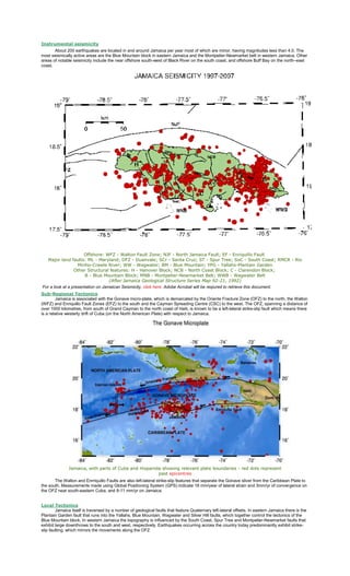
Offshore: WFZ - Walton Fault Zone; NJF - North Jamaica Fault; EF - Enriquillo Fault
Major land faults: ML - Maryland; DFZ - Duanvale; SCr - Santa Cruz; ST - Spur Tree; SoC - South Coast; RMCR - Rio
Minho-Crawle River; WW - Wagwater; BM - Blue Mountain; YPG - Yallahs-Plantain Garden
Other Structural features: H - Hanover Block; NCB - North Coast Block; C - Clarendon Block;
B - Blue Mountain Block; MNB - Montpelier-Newmarket Belt; WWB - Wagwater Belt
(After Jamaica Geological Structure Series Map 92-21, 1992)
For a look at a presentation on Jamaican Seismicity, click here. Adobe Acrobat will be reqiured to retrieve this document.
Sub-Regional Tectonics
Jamaica is associated with the Gonave micro-plate, which is demarcated by the Oriente Fracture Zone (OFZ) to the north, the Walton
(WFZ) and Enriquillo Fault Zones (EFZ) to the south and the Cayman Spreading Centre (CSC) to the west. The OFZ, spanning a distance of
over 1000 kilometres, from south of Grand Cayman to the north coast of Haiti, is known to be a left-lateral strike-slip fault which means there
is a relative westerly drift of Cuba (on the North American Plate) with respect to Jamaica.
Jamaica, with parts of Cuba and Hispanola showing relevant plate boundaries - red dots represent
past epicentres
The Walton and Enrriquillo Faults are also left-lateral strike-slip features that separate the Gonave sliver from the Caribbean Plate to
the south. Measurements made using Global Positioning System (GPS) indicate 18 mm/year of lateral strain and 3mm/yr of convergence on
the OFZ near south-eastern Cuba, and 8-11 mm/yr on Jamaica.
Local Tectonics
Jamaica itself is traversed by a number of geological faults that feature Quaternary left-lateral offsets. In eastern Jamaica there is the
Plantain Garden fault that runs into the Yallahs, Blue Mountain, Wagwater and Silver Hill faults, which together control the tectonics of the
Blue Mountain block. In western Jamaica the topography is influenced by the South Coast, Spur Tree and Montpelier-Newmarket faults that
exhibit large downthrows to the south and west, respectively. Earthquakes occurring across the country today predominantly exhibit strikeslip faulting, which mirrors the movements along the OFZ
2. Jamaica's Earthquake History
Jamaica’s recorded history is rife with incidences of felt earthquakes. The famous Port Royal earthquake of June 7, 1692 was
perhaps our largest and most damaging natural disaster. Although it was felt island-wide, the most extensive loss of life occurred at Port
Royal, where a portion of the town sank into the sea. At least 2,000 persons died as a result of an outbreak of yellow fever, which developed
after the quake. (To read more on this 1962 Earthquake, click here.)
The Great Kingston Quake of 1907 occurred January 14,of that year. Of the 48,000
people living in Kingston at the time, over 1000 perished, mostly in the fires following the
shocks (main and after-shocks). The aftershocks continued for the rest of the year. Some
9,000 people were left homeless throughout the island. Damage (building) for that event was
estimated at two million pounds (back then).(To read a news account on this 1907
Earthquake, click here.)
The March 1, 1957 event, affected mostly Western Jamaica. The most damages were
recorded in the parish of St. James, especially for its infrastructure such as buildings, bridges
and roads. This event resulted in three (3) deaths and three associated fires. A full list of
damaging earthquakes can be seen here in ourEarthquake Data page.
Monitoring for earthquakes in Jamaica began with the weather service in the late 19th
century. In the early 20th century the Jesuits Association also established seismograph
stations on the island. However, it was not until the early 1960s that the first modern
seismograph station was installed at Hope Gardens, Geological Survey Division. In 1963,
that station was moved to the Mona campus of the University of the West Indies, from where
the growth into the Jamaica Seismograph Network began. In the 1970s, the number of
stations increased to three and this enabled details of epicentres and focal depths of
earthquakes to be determined. Thus, the database of felt earthquakes extends back to the
17th century, while that for located events is only about 30 years long.
Artist's impression of 1692
Earthquake. Illustrated is the
liquefaction and ground failure as
the earth opens up to swallow the
unfortunate residents
Pictures of the damaged Parish Church, Westmoreland and a school in
St. James taken from The Gleaner, March 1957
Most Damaging Earthquakes in Jamaica
Year
Date
Maximum
Intensity
(EMS) *
Places Affected
Observed Damage
1667 -
VIII
-
Landslide
1688 March 1
VII
Port Royal
Houses and ships damaged
1692 June 7
X
Port Royal, Kingston, Vere Plains.
Also felt strongly island-wide
3,000 dead; buildings collapsed; liquefaction,
subsidence, landslides and water ejected
1771 Sept 3
VII
Port Royal, Kingston
Damage to structures, felt on boats in port.
November
1812
VIII
11
Kingston
Several people killed; walls fell, buildings
damaged
1824 April 10
Kingston; Spanish Town, St.
Loud noise accopmanied shock; some houses
Catherine; Old Harbour, Clarendon fell
1839
VII
November
VII
5
Montego Bay, St.James
Government buildings declared unsafe due to
damage
1907 Jan 14
IX
Kingston, Port Royal
1,000 dead; fire over 56 acres; most buildings
collapsed; water mains broken; landslides and
slumps; localized tsunami; statues rotated; near
total destruction of damage - est. 2 million
pounds sterling in damage
1914 August 3
VII
Eastern Jamaica
Buildings cracked, doors and windows out of
plumb; clocks stopped; stocks in drug stores
broken
1943 July 15
VII
St. Elizabeth
Landslides; many homeless; breakages of
3. merchandise in shops
1957 March 1
1993 Jan 13
2005 June 12
VIII
Montego Bay, St. James and felt
island-wide
4 dead; ladnslides; bridges damaged; rotation of
spires and monuments; springs increased flow
and muddied ; utility poles and lines broken;
breakages of items off shelves
VII
Kingston and St. Andrew. Also felt
island-wide
2 dead; items thrown off shelves and broke;
most were frightened; heavy furnitures shifted;
water splashed out of containers and pools;
much non-structural damage; few cases of
structural damage
VII
Central Jamaica - Felt strongest at
Aenon Town and Top Alston in
Clarendon; Silent Hill, Manchester;
Wait-a-bit and Lemon Walk,
Trelawny
Moderate to heavy structural damage on most
vulnerable structures; some people had to be
dug out of collapsed dwelling; minor injuries
from falling objects