Building Community Information Systems with Drupal and Open Layers
•
6 recomendaciones•3,578 vistas

Friday 23 October 2009 presentation at FOSS4G (Free and Open Spatial for Geospatial) Conference in Sydney Australia. Describes Geomemes work building Community Information Systems for indigenous groups in BC Canada using the Drupal CMS and Open Layers javascript library. Also binds to PostGIS.

Recomendados
Recomendados
Más contenido relacionado
Similar a Building Community Information Systems with Drupal and Open Layers
Similar a Building Community Information Systems with Drupal and Open Layers (20)
Último
Último (20)
Building Community Information Systems with Drupal and Open Layers
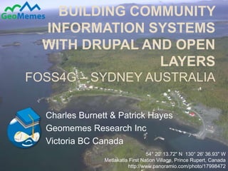
- 1. Building community information systems with Drupal and Open LayersFOSS4G – Sydney Australia Charles Burnett & Patrick Hayes Geomemes Research Inc Victoria BC Canada 1 54° 20' 13.72" N 130° 26' 36.93" W Metlakatla First Nation Village, Prince Rupert, Canada http://www.panoramio.com/photo/17998472
- 2. 2 FOSS4G4IC<->GOV All exchanges are contextualized by the cultures that are party to the exchange. “Prototypes of New Understanding” - Brian Jungen (Swiss/Dunne-za), Vancouver, Canada
- 3. Wawa of the BC Context 3 Wawa = Chinook Jargon: Kloshe Konaway!, Skookum INAC: Indian Act 1876, Federal responsibility Reserves: post gold rush, traders to settlers First Nation: Indigenous political unit (~203 in BC) Treaty: BC has a Treaty Commission, some FNs “in treaty”, 2 modern signed, Land/$$/Co-management Land Claims: negotiate through the courts “Duty to Consult” and Accomodation Referrals: BC Gov system for doing consultation TUS/TEK: Traditional Use Study, -Ecologial Knowledge EBM: Ecosystem Based Management
- 4. 4 Band Chief Councilor: “I need CED (“referrals”) reports with summary, maps, analysis, communications highlights.” School Teacher: “I need access to the maps and multimedia files to teach our culture.” Referrals Manager: “I need to track staff time spent on consultation.” Fisheries Officer: “I need a (spatialized) system to record environmental data.” Teeenager: “I want to access to some community data, calendars, blogs, job lists and our elections info.” Cultural Expert: “I need a better way of doing interviews and for digitizing our TUS/TEK/Arch data.” GIS techniciam: “I’m swamped and need help wit hdata entry, but we have no $$ for training.” CED Staffer: “I need a better way to track consultation. Paper copies suck!” 54° 20' 13.72" N 130° 26' 36.93" W Metlakatla First Nation Village, Prince Rupert, Canada
- 5. 5 To change the rules, change the tools Lee Felsenstein (1945-), computer engineer
- 6. CIS: One Basket, Many Views Cultural / Language Revitalization Spatial Data Storage & Viewing Community Building / Governance Drupal + PostGIS FN Data Basket Economic Development & Consultation (including Referrals Tracking) 6
- 7. Start with a GIS? Or a CMS? 7 Start with a Mapping Application, add CMS-ness Add tools to add/edit/manage non-geographic information, incl. multimedia Add tools to manage roles/access/views/communications/... + Use Scripting to generate reports Start with Content Management System (CMS) Add tools to interactively enter and display geographic information Add tools to link CMS with spatial databases + Use Scripting to generate reports
- 8. Content Management System 8 A content management system (CMS) is a computer application used to manage work flow needed to collaboratively create, edit, review, index, search, publish and archive various kinds of digital media and electronic text. Modular: Core (user management, security) Contributed Modules(1000s of modules to at data types and funtionality) E.g. Drupal Open Layers, Geo
- 9. 9
- 11. Die Zeit
- 12. Die Welt
- 13. CNN
- 15. NASA
- 16. NATO
- 18. IBM
- 19. Popular Science
- 20. Fast Company
- 21. America Online
- 22. Sun Microsystems
- 23. Novell
- 24. Yahoo!
- 27. Nike
- 28. Forbes
- 29. Warner Bros
- 30. 20th Century Fox
- 31. MacWorld
- 32. Adobe
- 33. Java.net
- 35. Drupal 12
- 38. Which “preset”?
- 39. Filters (which nodes?)
- 45. Drupal Open Layers: Capabilities 14 Create spatial nodes in Drupal (point/lines/polygon) – don’t need code to use the OL API Can make complex maps, lots of layers DOL API has “glue” to approximately 30% of OL library One level up: Snippet – small code to create easy People sharing Snippets Upload shapefile (stored in MySQL Spatial or PostGIS), Drupal doing the db abstraction Point and click map building and styling Styling Engine pretty powerful now Dynamic styles (attributes in Drupal can be used to make styles) E.g. Taxonomy image for icons, or cck field for line weight
- 46. Drupal Open Layers: Next Steps 15 We have a solid API and a rapidly growing group of developers. Core Functionality (Drupal/OL glue) ready to be built upon... DOL 2.0 is accepting new feature requests http://drupal.org/project/openlayers Add easier way to upload shapefiles Expand to WMS/WFS... All data types in Open Layers Integrate Drupal Chaos Tools module; allows custom bundles of snippets as a ‘feature’ -> module Improved Styling
- 47. CIS: Community Health 16
- 48. CIS: Language Revitalization FNs = spoken language cultures Drupal, Multimedia Javascript links automatically seeded when a new “term” + MP3 added ...Localization! ...Cross-site API! ...+ Maps! ... education... 17 http://maps.fphlcc.ca/
- 49. CIS: Advanced File Management 18
- 50. ...DEMO 19 Gilakasla – Thank-you! http://geomemes.com charles@geomemes.com
- 51. Demo Functionality 20 Add individual TUS sites - (CCK, Related Fields, DOL) Add/modify many site nodes (Views) Load Shapefile - (Table Wizard, Geo) Show different features on the same map -(Views/Roles/Permissions) Filter maps – (Faceted Search) WMS/WFS – (DOL Snippets, API calls) Links to desktop – (Geo, custom PHP) Reporting – (DOL, Geo, PHP calls to PostGIS)
- 52. Community Information System 21
- 53. 1. Add Site 22
- 54. 1. Add Site 23
- 55. 1. Add Site 24
- 56. 2. View Sites 25
- 57. 3. Show diff. features on same map 26 Views/Roles/Permissions
- 58. 4. View Sites, Filter by User 27
- 59. 5. Basic map... ...WMS/WFS 28
- 60. 5. Basic map... ...WMS/WFS... 29
- 61. 5. Basic map... ...WMS/WFS... 30
- 62. 5. Basic map... ...WMS/WFS... 31
- 63. 5. Basic map... ...WMS/WFS... 32
- 64. 6. Links to desktop 33
- 65. 7. Report Generation 34 CIS... DOL, PHP, PostGIS, PDF module
Notas del editor
- The idea of “separation of presentation (form, style) and content” means that data once stored it can be viewed in many ways.And when we say data, we mean everything including text, pdf, doc, spreadsheets, multimedia (images, audio, video), and maps.So, data can be used in a number of ways, and for a number of applications.The clever thing about our approach is that the underlying software (in our case, the Drupal Content Management System, http://drupal.org) was purpose built for collaborative information and multimedia data sharing.We suggest that FNs start with a system for Economic Development/Land Management (including Referrals Tracking). Then add other components like web-forms and views for Language Revitalization and TUS/TEK Data Collection. Later, you can leverage your investment by moving more of your GIS Systems into the common data basket. All the while you can start to let Band members build their own web-pages and access the multimedia content. Eventually, you can use the system to have Band members learn about initiatives before voting - Governance.
- CMS: a computer application used to manage work flow needed to collaboratively create, edit, review, index, search, publish and archive various kinds of digital media and electronic texthttp://en.wikipedia.org/wiki/Content_management_system
- http://drupal.org/books
- Show different features on the same map -(Views/Roles/Permissions)