
Recomendados
Más contenido relacionado
La actualidad más candente
La actualidad más candente (19)
Destacado
Destacado (15)
Similar a HPU NCS2200 Topographic maps powerpoint_le
Similar a HPU NCS2200 Topographic maps powerpoint_le (20)
Más de cooperk2
Más de cooperk2 (20)
Último
Último (20)
HPU NCS2200 Topographic maps powerpoint_le
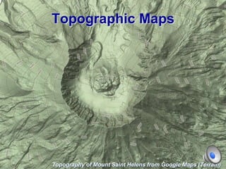
- 1. Topographic Maps Topography of Mount Saint Helens from Google Maps (Terrain)
- 2. Zoomed in view of Mt. St. Helens Caldera - USGS Topographic Map of Mt. St. Helens
- 3. Prime Meridian & Tropics
- 4. Latitude and Longitude • Latitude lines run laterally, East to West. • Longitude Line run vertically, North to South
- 5. Latitude and Longitude Based on TRUE NORTH (not magnetic north).
- 6. Divisions • Like time and temperature, latitude and longitude are divided into degrees, minutes, and seconds. • For example: N88º30’45” = 88 degrees (out of 90) north of the equator; plus 30/60 minutes, and 45/60 seconds north beyond that.
- 7. Declination True North= North on a map Magnetic North= North on your compass The difference between the MAGNETIC NORTH and TRUE NORTH is called the MAGNETIC DECLINATION.
- 8. Quadrangles
- 9. Scales • Could be a ratio: 1:24000 • Could be a fraction: 1/24000 • Could be a bar:
- 10. Map symbols
- 11. Map symbols
- 12. TOPO MAPS • A topographic map is a two dimensional representation of three dimensional space. • Utilizes contour lines to show elevation. • Contour lines are lines of equal elevation.
- 13. • Elevation is distance above sea level. • A contour line connects points of the same elevation. • If you walked around an entire mountain staying on the same contour line, you wouldn’t change elevation.
- 14. Index contours • If we wrote the elevation of every contour line on that line, then our map would be covered in numbers. • Instead, we use index contour lines. 1. Usually darker lines 2. Have the elevation marked on them
- 15. Index contours
- 16. Contour interval • How much vertical space (i.e. elevation) there is between contour lines. • This is the Key to the topo map
- 18. Rules for Contour Lines • Contour lines always close to form an irregular circle, it’s just that sometimes you can’t see the complete thing. • Contour lines will make a ‘v’ in the upstream direction a of a stream.
- 19. Contour Lines ‘V’ Upstream Topography of Appalachian valley surrounding the Rapidan River, Va (from Google Maps - Terrain)
- 20. Rules Continued • Lines always increase unless indicated by hash marks. These hash marks indicate a depression. • Page 150 and figures 9.4-9.7 in your manual is a great resource
- 24. Relief • The difference in elevation between two points. Total Relief • The difference in elevation between the highest point and the lowest point on a map.
- 25. What is the relief between point X and point Y? 40 ft
- 26. Gradient • The change in elevation from one point to another is the slope of the terrain. This is a measure of how steep the slope is, and also known as the gradient. 12 12 XX YY Run Rise Gradient
- 27. What is the gradient between point X and point Y? 40 m / 3 km = 40 m / 3000 m = 0.013
- 28. Widely spaced contour lines = GENTLE Close contour lines = STEEP CRATER LAKE NATIONAL PARK USGS TOPOGRAPHIC MAP
- 29. Compass 42ºE
- 30. How to Measure a Bearing in Degrees Mount Saint Helens USGS Quadrangle BUTTE CAMP DOME N S EW 45° Bearing Measurement Quadrant Method = S 45° W Azimuthal = 225°
- 31. Benchmark a point that has been accurately measured for its position and elevation
- 33. Mount St. Helens
- 39. Volcanic Deformation and Evolution of Mt. Saint Helens
- 40. B.A. Digital perspective view derived from USGS Digital Elevation Model (DEM) of Mount St. Helens as seen from the northwest prior to the catastrophic eruption of May 18, 1980. Created with Geographic Information Systems (GIS).
- 41. B. Digital perspective view derived from USGS DEM of Mount St. Helens following the catastrophic eruption of May 18, 1980. The 1980-86 lava dome has begun growing in the center of the crater.
- 42. C. Light Detection And Ranging (LIDAR)-derived digital perspective view of the volcano on September 22, 2003, one year before the start of its latest eruption. The 1980-86 lava dome and Crater Glacier occupy the crater.
- 43. D. Digital perspective view derived from both LIDAR DEM and DEM constructed by photogrammetric techniques, showing new lava dome, 1980-86 dome, and advancing Crater Glacier on July 5, 2007.
- 44. September 22, 2003 – 1980-86 lava dome quiet
- 45. October 4, 2004 – Mt. St. Helens reawakened
- 46. February 21, 2005 – Whaleback Structure
- 47. July 14, 2005 – Whaleback breaks apart, tall spine extruded then crumbled
- 48. October 24, 2005 – New lava dome pushes west, cracking glacier
- 49. February 9, 2006 – Massive fin of hot lava projected skyward
- 50. February 21, 2005 – Whaleback Structure photo by Steve P. Schilling
- 51. Actively growing fin of lava as seen from the 1980-86 lava dome on April 28, 2006. Fin is about 100 meters tall (Photograph by Daniel Dzurisin).
- 53. NASA Source
- 54. NASA Source
- 56. Mt. Saint Helens Resources A Volcano Rekindled: The Renewed Eruption of Mount St. Helens, 2004–2006 http://pubs.usgs.gov/pp/1750/ Rebuilding Mount St. Helens http://pubs.usgs.gov/sim/2006/2928/ A New Perspective on Mount St. Helens—Dramatic Landform Change and Associated Hazards at the Most Active Volcano in the Cascade Range http://pubs.usgs.gov/sim/3008/ Historic Digital Elevation Models (DEMs) http://ned.usgs.gov/Ned/historic.asp USGS Fact Sheet: Mount St. Helens – From the 1980 Eruption to 2000 http://pubs.usgs.gov/fs/2000/fs036-00/ Geologic Map of the Sasquatch Steps Area, North Flank of Mount St. Helens, Washington http://geopubs.wr.usgs.gov/i-map/i2463/ 360 ° Panoramic View of Mount St. Helens Crater http://www.panoramas.dk/fullscreen6/f34-Mt-St-Helens.html Teacher’s Corner – Mt. Saint Helens National Volcanic Monument http://www.fs.fed.us/gpnf/mshnvm/education/teachers-corner/library/nasa-aster-series.shtml Mount St. Helens National Volcanic Monument http://www.fs.fed.us/gpnf/mshnvm/
- 57. Today’s Lab • Construct a topographic map of the Egyptian Pyramid of the Pharaoh Khafre • Learn to read and navigate using topographic maps • Create a topographic profile • Examine the topographic map of Mt. St. Helens • Learn about volcanic deformation and evolution of Mt. Saint Helens from digital topographic data
- 58. Giza topographical map Khafre pyramid from Khufu’s quarry The Sphinx
- 59. The Great Sphnix of Giza and the Pyramid of Khafre
- 60. Topographic maps • http://geology.isu.edu/geostac/Field_Exerc ise/topomaps/topo_interp.htm • http://www.tasagraphicarts.com/activities/p rofile.html