SlideShare una empresa de Scribd logo
1 de 10
The Case for Interpreting the ~5,000 km2 "Upland Deposits" of the U.S. Mid-Atlantic Coastal Plane as Chesapeake Bay Crater Ejecta Part I David L. Griscom impact Glass research international San Carlos, Sonora, M éxico Slightly modified and lengthened from talk presented at the: Penrose Conference “Late Eocene Earth,” Monte C ò n e ro, Italy, October 6, 2007
Geology of the State of Virginia   Silurian and Devonian Sandstones The Chesapeake Bay Structure Southern Maryland Piedmont  Coastal Plain Fall Line 50 km 50 mi This and other similar maps taken from K. Frye,  Roadside Geology of Virginia  (Missoula Press, 1986) Blue Ridge
Geology of U.S. Mid-Atlantic Coastal Plain   Sandstones: Silurian Washington, DC Upper Chesapeake Bay Silurian and Devonian Sandstones Hypothetical Anticlines ~200 Million Years Ago, Now Eroded Atlantic Ocean Blue Ridge Fall Line Sand, Gravel and Clay (Soft) 350 km Ancient Metamorphic Rocks (Hard) , Devonian “ Upland Deposits”
The “Upland Deposits” of Southern Maryland: A 1957 Field Study/Review Article by John Schlee ,[object Object],[object Object],[object Object],●  A Petrological Oddity within the “Upland Gravels”: “ Secondarily introduced iron oxide locally cements the sand and gravel along definite zones and in large irregular masses up to 3 feet across” ,[object Object],[object Object],(2)   a lower  “ gravel member ”  (mostly quartzite)   ~1 m thick   Loam 90% Quartz ~1 cm 9 m ~1 m “ Upland Gravels” “ Peanut Brittle-Like”
Soft coastal plane sediments “ Upland Deposits” of Southern Maryland Currently Accepted Emplacement Mechanism (Hack, 1955; Schlee, 1957) Silurian & Devonian Sandstone Outcrops Blue Ridge Water Gap Fall Line Mouth of Potomac River Erosion   ~65 km ~130 km ~65 km 128 mm Cobbles ,[object Object],[object Object],[object Object],—  37 years before the discovery of the crater ! Shenandoah R. Potomac River “ Ancestral” Potomac River Transport Without Deposition  Deposition Without Erosion … and that the 75-year controversy regarding origins had been resolved in 1957. ,[object Object],We do  not  see such things happening today.
“ Upland Deposits” of Southern Maryland  A Contemporary Schematic Cross Section N.B. “Upland deposits” are not present here in  this  section. However, they do occur at similar elevations ~25 km west (at Tysons Corners, Virginia). Adapted from USGS (2000) Eocene Paleocene Miocene ,[object Object],NW  SE Crater 120 km Cretaceous Miocene (?) Potomac River Definitely older than the crater Currently regarded as  younger than the crater Meters 150 – 100 – 50 – 0 – 0 – -50 – -100 – … and it exhibits no hint of ancient shorelines |  |  |  |  |   |  |  |  0  20  40  60  80  100  120  140 Distance (Kilometers) Upland Deposits Idealized Chesapeake Bay Crater Ejecta Blanket
The “Upland Deposits”   Data, Analyses, and Quotes from John Schlee (1957) Upland Gravels ,[object Object],[object Object],Log 2 (Size in mm) 4  8  16  32  64  128  256 mm ,[object Object]
The “Upland Deposits”   Gravel-Size Data and Analyses of John Schlee (1957) -6.0 -5.5 -4.5 -4.0 -5.0 -3.5 -3.0 -2.5 -2.0 Washington, DC N.B. Schlee’s gravel-size contours are labeled by the negative log to the base 2 of the observed modal sizes (phi units). Noting that the contours were more or less equally spaced in phi units, Schlee (1957) perceived a possible exponential progression.  To test this notion, he took four  additional  sets of gravel-size data along four approximately-linear paths running generally southeasterly of the U.S. Capitol.
128 mm The “Upland Deposits”   Gravel-Size Data and Analyses of John Schlee (1957) Direction of the Center  of the Chesapeake Bay Crater  Mean  Direction  of  Apparent Dip of the Gravel Exposures Washington, DC 32 mm 16 mm 8 mm 4 mm My Interpretation: Atmospheric size sorting of ejecta in flight. * -6.0 -5.5 -4.5 -4.0 -5.0 -3.5 -3.0 -2.5 -2.0 - - - - - Extrapolates to 128-mm cobbles at ~15 km northwest of Washington, DC –  where most rocks this size are  petrologically  different   from the upland gravels ! *Schultz, Gault  (1979) 64 mm + Factor of 15!
The “Upland Deposits” of Southern Maryland  Model of Hack (1955) and Schlee (1957):  Deposition by the Potomac River ~10 to ~3 Million Years Ago ,[object Object],Washington, DC Extrapolated Source ,[object Object],[object Object],25 km They extend far southward… Laterally migrating channel growing ~1 m deeper per kilometer of sideways displacement Hypothetical Courses of Ancestral Potomac River

Más contenido relacionado

La actualidad más candente

Sea floor spreading
Sea floor spreadingSea floor spreading
Sea floor spreadingbgriesmer
 
Sea-Floor Spreading Notes - Jenny
Sea-Floor Spreading Notes - JennySea-Floor Spreading Notes - Jenny
Sea-Floor Spreading Notes - JennyJenny Dixon
 
Continental drift &and sea floor spreading
Continental drift &and sea floor spreadingContinental drift &and sea floor spreading
Continental drift &and sea floor spreadingMd Asif Hasan
 
2.4 tectonic plate boundaries
2.4 tectonic plate boundaries 2.4 tectonic plate boundaries
2.4 tectonic plate boundaries mojavehack
 
Sea Floor Spreading
Sea Floor SpreadingSea Floor Spreading
Sea Floor Spreadingbjansen
 
Naturalists at Large: Plate tectonics
Naturalists at Large: Plate tectonicsNaturalists at Large: Plate tectonics
Naturalists at Large: Plate tectonicsPhat Nattie
 
Continental drift and seafloor spreading
Continental drift and seafloor spreadingContinental drift and seafloor spreading
Continental drift and seafloor spreadingSherry Ann Bagotsay
 
Sea floor spreading
Sea floor spreadingSea floor spreading
Sea floor spreadingtagalog123
 
Lab ten plate tectonics
Lab ten plate tectonicsLab ten plate tectonics
Lab ten plate tectonicsLisa Schmidt
 
Ch12 earthandlifehistorysection3
Ch12 earthandlifehistorysection3Ch12 earthandlifehistorysection3
Ch12 earthandlifehistorysection3cwyatt01
 
The Dynamic Earth
The Dynamic EarthThe Dynamic Earth
The Dynamic Earthduncanpatti
 

La actualidad más candente (20)

Sea floor spreading
Sea floor spreadingSea floor spreading
Sea floor spreading
 
seafloor spreading theory
seafloor spreading theoryseafloor spreading theory
seafloor spreading theory
 
Sea-Floor Spreading Notes - Jenny
Sea-Floor Spreading Notes - JennySea-Floor Spreading Notes - Jenny
Sea-Floor Spreading Notes - Jenny
 
Ga 13 05
Ga 13 05Ga 13 05
Ga 13 05
 
Sea Floor spreading
Sea Floor spreading Sea Floor spreading
Sea Floor spreading
 
Continental drift &and sea floor spreading
Continental drift &and sea floor spreadingContinental drift &and sea floor spreading
Continental drift &and sea floor spreading
 
Seafloor Spreading
Seafloor SpreadingSeafloor Spreading
Seafloor Spreading
 
Sea floor
Sea floorSea floor
Sea floor
 
Why geology rocks
Why geology rocksWhy geology rocks
Why geology rocks
 
Continental drift
Continental drift Continental drift
Continental drift
 
2.4 tectonic plate boundaries
2.4 tectonic plate boundaries 2.4 tectonic plate boundaries
2.4 tectonic plate boundaries
 
Plate tectonics
Plate tectonicsPlate tectonics
Plate tectonics
 
Sea Floor Spreading
Sea Floor SpreadingSea Floor Spreading
Sea Floor Spreading
 
Naturalists at Large: Plate tectonics
Naturalists at Large: Plate tectonicsNaturalists at Large: Plate tectonics
Naturalists at Large: Plate tectonics
 
Plate tectonics quiz-fernando
Plate tectonics quiz-fernandoPlate tectonics quiz-fernando
Plate tectonics quiz-fernando
 
Continental drift and seafloor spreading
Continental drift and seafloor spreadingContinental drift and seafloor spreading
Continental drift and seafloor spreading
 
Sea floor spreading
Sea floor spreadingSea floor spreading
Sea floor spreading
 
Lab ten plate tectonics
Lab ten plate tectonicsLab ten plate tectonics
Lab ten plate tectonics
 
Ch12 earthandlifehistorysection3
Ch12 earthandlifehistorysection3Ch12 earthandlifehistorysection3
Ch12 earthandlifehistorysection3
 
The Dynamic Earth
The Dynamic EarthThe Dynamic Earth
The Dynamic Earth
 

Similar a Part1GriscomPenroseConferenceLecture

Part2GriscomPenroseConferenceLecture
Part2GriscomPenroseConferenceLecturePart2GriscomPenroseConferenceLecture
Part2GriscomPenroseConferenceLecturedlgriscom
 
Part3GriscomPenroseConferenceLecture
Part3GriscomPenroseConferenceLecturePart3GriscomPenroseConferenceLecture
Part3GriscomPenroseConferenceLecturedlgriscom
 
Paleoflow Final draft
Paleoflow Final draftPaleoflow Final draft
Paleoflow Final draftThomas Hunter
 
Orchard Beach, Pelham BayVirtual Field TripWhere are.docx
Orchard Beach, Pelham BayVirtual Field TripWhere are.docxOrchard Beach, Pelham BayVirtual Field TripWhere are.docx
Orchard Beach, Pelham BayVirtual Field TripWhere are.docxhopeaustin33688
 
Orchard Beach, Pelham BayVirtual Field TripWhere are
Orchard Beach, Pelham BayVirtual Field TripWhere areOrchard Beach, Pelham BayVirtual Field TripWhere are
Orchard Beach, Pelham BayVirtual Field TripWhere arelianaalbee2qly
 
Orchard Beach, Pelham BayVirtual Field TripWhere are.docx
Orchard Beach, Pelham BayVirtual Field TripWhere are.docxOrchard Beach, Pelham BayVirtual Field TripWhere are.docx
Orchard Beach, Pelham BayVirtual Field TripWhere are.docxjacksnathalie
 
continentahjjjjjjjjjghghhjghuyldrift.ppt
continentahjjjjjjjjjghghhjghuyldrift.pptcontinentahjjjjjjjjjghghhjghuyldrift.ppt
continentahjjjjjjjjjghghhjghuyldrift.pptkrishnarajgire71
 
Geologic Evolution of the Grand Canyon
Geologic Evolution of the Grand CanyonGeologic Evolution of the Grand Canyon
Geologic Evolution of the Grand CanyonMitchell Jennings
 
Biogeo lec 6 the changing earth
Biogeo lec 6   the changing earthBiogeo lec 6   the changing earth
Biogeo lec 6 the changing earthMatt Robinson
 
Were Most of Earth's Fossil-Bering Sedimentary Rock Layers Deposited by Noah'...
Were Most of Earth's Fossil-Bering Sedimentary Rock Layers Deposited by Noah'...Were Most of Earth's Fossil-Bering Sedimentary Rock Layers Deposited by Noah'...
Were Most of Earth's Fossil-Bering Sedimentary Rock Layers Deposited by Noah'...Tim Helble
 
The Geology of New Orleans
The Geology of New OrleansThe Geology of New Orleans
The Geology of New OrleansJustin Kray
 
Geology: Plate Tectonics
Geology: Plate TectonicsGeology: Plate Tectonics
Geology: Plate TectonicsFaryal Saleemi
 
Study of plate tectonics of the earth, or plate movement,
Study of plate tectonics of the earth, or plate movement, Study of plate tectonics of the earth, or plate movement,
Study of plate tectonics of the earth, or plate movement, Jahangir Alam
 

Similar a Part1GriscomPenroseConferenceLecture (20)

Part2GriscomPenroseConferenceLecture
Part2GriscomPenroseConferenceLecturePart2GriscomPenroseConferenceLecture
Part2GriscomPenroseConferenceLecture
 
Part3GriscomPenroseConferenceLecture
Part3GriscomPenroseConferenceLecturePart3GriscomPenroseConferenceLecture
Part3GriscomPenroseConferenceLecture
 
Mike_Stoever_Text
Mike_Stoever_TextMike_Stoever_Text
Mike_Stoever_Text
 
Paleoflow Final draft
Paleoflow Final draftPaleoflow Final draft
Paleoflow Final draft
 
Orchard Beach, Pelham BayVirtual Field TripWhere are.docx
Orchard Beach, Pelham BayVirtual Field TripWhere are.docxOrchard Beach, Pelham BayVirtual Field TripWhere are.docx
Orchard Beach, Pelham BayVirtual Field TripWhere are.docx
 
Orchard Beach, Pelham BayVirtual Field TripWhere are
Orchard Beach, Pelham BayVirtual Field TripWhere areOrchard Beach, Pelham BayVirtual Field TripWhere are
Orchard Beach, Pelham BayVirtual Field TripWhere are
 
Orchard Beach, Pelham BayVirtual Field TripWhere are.docx
Orchard Beach, Pelham BayVirtual Field TripWhere are.docxOrchard Beach, Pelham BayVirtual Field TripWhere are.docx
Orchard Beach, Pelham BayVirtual Field TripWhere are.docx
 
continentahjjjjjjjjjghghhjghuyldrift.ppt
continentahjjjjjjjjjghghhjghuyldrift.pptcontinentahjjjjjjjjjghghhjghuyldrift.ppt
continentahjjjjjjjjjghghhjghuyldrift.ppt
 
Continentaldrift
ContinentaldriftContinentaldrift
Continentaldrift
 
Geologic Evolution of the Grand Canyon
Geologic Evolution of the Grand CanyonGeologic Evolution of the Grand Canyon
Geologic Evolution of the Grand Canyon
 
Plate tectonic
Plate tectonicPlate tectonic
Plate tectonic
 
Biogeo lec 6 the changing earth
Biogeo lec 6   the changing earthBiogeo lec 6   the changing earth
Biogeo lec 6 the changing earth
 
Mike_Stoever_Slides
Mike_Stoever_SlidesMike_Stoever_Slides
Mike_Stoever_Slides
 
Were Most of Earth's Fossil-Bering Sedimentary Rock Layers Deposited by Noah'...
Were Most of Earth's Fossil-Bering Sedimentary Rock Layers Deposited by Noah'...Were Most of Earth's Fossil-Bering Sedimentary Rock Layers Deposited by Noah'...
Were Most of Earth's Fossil-Bering Sedimentary Rock Layers Deposited by Noah'...
 
The Geology of New Orleans
The Geology of New OrleansThe Geology of New Orleans
The Geology of New Orleans
 
Plate Tectonics I
Plate Tectonics IPlate Tectonics I
Plate Tectonics I
 
PLATE-TECTONICS.pptx
PLATE-TECTONICS.pptxPLATE-TECTONICS.pptx
PLATE-TECTONICS.pptx
 
Geology: Plate Tectonics
Geology: Plate TectonicsGeology: Plate Tectonics
Geology: Plate Tectonics
 
8. dinamica terrestre 1° medio
8.  dinamica terrestre  1° medio8.  dinamica terrestre  1° medio
8. dinamica terrestre 1° medio
 
Study of plate tectonics of the earth, or plate movement,
Study of plate tectonics of the earth, or plate movement, Study of plate tectonics of the earth, or plate movement,
Study of plate tectonics of the earth, or plate movement,
 

Part1GriscomPenroseConferenceLecture

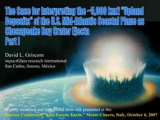
  • 1. The Case for Interpreting the ~5,000 km2 "Upland Deposits" of the U.S. Mid-Atlantic Coastal Plane as Chesapeake Bay Crater Ejecta Part I David L. Griscom impact Glass research international San Carlos, Sonora, M éxico Slightly modified and lengthened from talk presented at the: Penrose Conference “Late Eocene Earth,” Monte C ò n e ro, Italy, October 6, 2007
  • 2. Geology of the State of Virginia Silurian and Devonian Sandstones The Chesapeake Bay Structure Southern Maryland Piedmont Coastal Plain Fall Line 50 km 50 mi This and other similar maps taken from K. Frye, Roadside Geology of Virginia (Missoula Press, 1986) Blue Ridge
  • 3. Geology of U.S. Mid-Atlantic Coastal Plain Sandstones: Silurian Washington, DC Upper Chesapeake Bay Silurian and Devonian Sandstones Hypothetical Anticlines ~200 Million Years Ago, Now Eroded Atlantic Ocean Blue Ridge Fall Line Sand, Gravel and Clay (Soft) 350 km Ancient Metamorphic Rocks (Hard) , Devonian “ Upland Deposits”
  • 4.
  • 5.
  • 6.
  • 7.
  • 8. The “Upland Deposits” Gravel-Size Data and Analyses of John Schlee (1957) -6.0 -5.5 -4.5 -4.0 -5.0 -3.5 -3.0 -2.5 -2.0 Washington, DC N.B. Schlee’s gravel-size contours are labeled by the negative log to the base 2 of the observed modal sizes (phi units). Noting that the contours were more or less equally spaced in phi units, Schlee (1957) perceived a possible exponential progression. To test this notion, he took four additional sets of gravel-size data along four approximately-linear paths running generally southeasterly of the U.S. Capitol.
  • 9. 128 mm The “Upland Deposits” Gravel-Size Data and Analyses of John Schlee (1957) Direction of the Center of the Chesapeake Bay Crater Mean Direction of Apparent Dip of the Gravel Exposures Washington, DC 32 mm 16 mm 8 mm 4 mm My Interpretation: Atmospheric size sorting of ejecta in flight. * -6.0 -5.5 -4.5 -4.0 -5.0 -3.5 -3.0 -2.5 -2.0 - - - - - Extrapolates to 128-mm cobbles at ~15 km northwest of Washington, DC – where most rocks this size are petrologically different from the upland gravels ! *Schultz, Gault (1979) 64 mm + Factor of 15!
  • 10.