SlideShare una empresa de Scribd logo
1 de 15
Devils Tower
  By: Elizabeth Bender
   GEO 111 Fall 2012
Devils Tower
 Warning: Notice is hereby given that
  any person or persons who injure or
  destroy or, without specific authority
    from the Secretary of the Interior,
excavate or appropriate any historic or
 prehistoric ruin, monument, object of
antiquity, or of scientific interest, for the
protection of which this reservation was
  created, will be subject to arrest and
punishment under the provisions of the
acts of Congress approved February 6,
         1905, and Jun 8,1908.
The Basics
Approximately 300 miles north of Cheyenne,
 Wyoming, lies American's first National
 Monument.
The Basics
It stands 1,270
   feet above the
   Belle Fourche
   River below,
   and measures
   180 feet east to
   west and 300
   feet north to
   south.
The neighborhood
There are three named layers of sedimentary rocks
       exposed at the base of Devils Tower.
The neighborhood
The oldest layer at the bottom
  is called the Spearfish
  Formation, named after the
  town Spearfish, South
  Dakota. This layer was
  formed during the Triassic
  Epoch approximately 240
  million years ago, when
  most of the surrounding
  area was part of the sea.
  The composition of the
  Spearfish Formation
  includes mudstones and
  sandstones.
The neighborhood
The middle layer is
  known as the
  Gypsum Springs
  Formation and is
  mostly gypsum.
  It was formed
  during the
  Jurassic Epoch
  150 million years
  ago. Gypsum is
  formed in natural
  saline waters.
The neighborhood
The final layer of Devils
  Tower is the Sundance
  Formation. This is the
  youngest formation of
  the monolith, forming
  relatively shortly after
  the Gypsum Springs
  Formation. The layer is
  named after the
  Sundance Sea in which
  it was deposited and
  ripple marks from
  receding water can still
  be seen within this
  layer.
Formation
Devil's Tower is an igneous rock formation
   created by intrusion. Igneous intrusion
   occurs when magma solidifies before it
   breaks through Earth's crust. The layer
   above the intrusion is pushed skyward
   creating, in this case, a massive bulge under
   the sedimentary rock crust.
As the magma cooled, it shrank it size, forming
   the four, five, six, even seven sided pillars of
   Devils Tower.
As the continents shifted and water eroded away
   the sedimentary layers, the phonolitic
   porphyry monolithic pluton was exposed.
Geologist believe that while Devils Tower formed
   from cooling magma 50 million years ago
   during the Eocene Epoch, but it was not
   exposed until 1-2 million years ago.
Additional Research Needed
Other theories state that Devils Tower is a laccolith or
  a volcanic neck. Geologists argue that Devils
  Tower would be much larger than it is if it were a
  laccolith, and there is no evidence of volcanic
  activities in the last 50 million years in the area.
                                            Click to
                                            watch
Weathering & Erosion 101


The 1,000 feet of sedimentary layers have eroded over the last
  1-2 million years exposing the much harder igneous rock
  below. Some layers washed away with the receding
  Sundance Sea. Water of the Belle Fourche River Valley have
  washed away the loose soil and the eroded debris from the
  damaging rain and snow. Erosion exposed the monolith as it
  stands today. Frost wedging continues to break off small
  pieces that are swept away by water, wind, or people.
Erosion of Arid Land
   Wyoming, though once a body
   of water, is now a relatively
   arid land. The base of Devils
   Tower shows evidence of
   differential weathering and
   erosion. The sedimentary
   layers remaining at the base
   have eroded much faster than
   the igneous rock tower above.
   This has created the different
   slope and the dramatic
   distinction between the two
   types.

The obviousness of the impressive change between the igneous and sedimentary
                 layers is due to the arid climate of Wyoming.
Erosion of Arid Land
The wind has also affected areas
  of Devils Tower. The monolith
  and surrounding areas are
  subject to deflation and
  abrasion. Dry particles are
  blown away, in deflation, and
  deposited miles away. Sands
  that are swept away don't
  leave without abrading the
  solid surfaces. These Aeolian
  processes are not as
  destructive as water, but signs
                                    Click to
  are prevalent at Devils Tower
                                    watch
  and evidence can be found in
  the surrounding areas of
  Aeolian deposited particles.
Very Brief Human Geography
Before it was named a
  national monument,
  Devils Tower was
  believed to be formed by
  the claws of a giant bear
  as it was chasing two
  girls of the native Crow
  Tribe. A spirit made the
  rock grow until the bear
  could no longer reach
  them.
1906 FDR made Devils
  Tower America’s first
  national monument.
Very Brief Human Geography

In 1977, Steven
  Spielberg directed
  “Close Encounters
  of the Third Kind,” a
  movie about UFOs
  and supernatural
  activities
  surrounding the
  monolith.

Más contenido relacionado

La actualidad más candente

Coastal geography waves, features of erosion and deposition, longshore drift
Coastal geography waves, features of erosion and deposition, longshore driftCoastal geography waves, features of erosion and deposition, longshore drift
Coastal geography waves, features of erosion and deposition, longshore driftOral Johnson
 
Lithosphere 1 notes
Lithosphere 1 notesLithosphere 1 notes
Lithosphere 1 notesRobin Seamon
 
Chapter 1 – the Restless Earth
Chapter 1 – the Restless EarthChapter 1 – the Restless Earth
Chapter 1 – the Restless EarthNoel Hogan
 
Volcanoes- CSEC GEOGRAPHY
Volcanoes- CSEC GEOGRAPHYVolcanoes- CSEC GEOGRAPHY
Volcanoes- CSEC GEOGRAPHYOral Johnson
 
Introduction to earth processes
Introduction to earth processesIntroduction to earth processes
Introduction to earth processesamandayoung313
 
Physical Geography Leaving Cert Short Notes
Physical Geography Leaving Cert Short NotesPhysical Geography Leaving Cert Short Notes
Physical Geography Leaving Cert Short NotesNoel Hogan
 
CSEC Geography- Internal Forces - Plate Tectonics and Earthquakes
CSEC Geography- Internal Forces - Plate Tectonics and EarthquakesCSEC Geography- Internal Forces - Plate Tectonics and Earthquakes
CSEC Geography- Internal Forces - Plate Tectonics and EarthquakesOral Johnson
 
Rivers- CSEC GEOGRAPHY
Rivers- CSEC GEOGRAPHYRivers- CSEC GEOGRAPHY
Rivers- CSEC GEOGRAPHYOral Johnson
 
Ss Chapter 19.3
Ss Chapter 19.3Ss Chapter 19.3
Ss Chapter 19.3mkeithnash
 
Intorduction to Volcanology, Weathering, Erotion, Dispertion and Soil.
Intorduction to Volcanology, Weathering, Erotion, Dispertion and Soil.Intorduction to Volcanology, Weathering, Erotion, Dispertion and Soil.
Intorduction to Volcanology, Weathering, Erotion, Dispertion and Soil.Mark Barbero
 
Earth's processes--Danielle Lewis
Earth's processes--Danielle LewisEarth's processes--Danielle Lewis
Earth's processes--Danielle Lewismontathomas
 
Forces that shape our earth
Forces that shape our earthForces that shape our earth
Forces that shape our earthglascod
 
Endogenic processes - The Process Within
Endogenic processes - The Process WithinEndogenic processes - The Process Within
Endogenic processes - The Process WithinRichie Jake Generale
 
Ii. d. deformation of the crust
Ii. d. deformation of the crustIi. d. deformation of the crust
Ii. d. deformation of the crustMarian Santos
 
Chp2 Forces Building the Land
Chp2 Forces Building the LandChp2 Forces Building the Land
Chp2 Forces Building the Landsandraabate
 

La actualidad más candente (20)

Coastal geography waves, features of erosion and deposition, longshore drift
Coastal geography waves, features of erosion and deposition, longshore driftCoastal geography waves, features of erosion and deposition, longshore drift
Coastal geography waves, features of erosion and deposition, longshore drift
 
Lithosphere 1 notes
Lithosphere 1 notesLithosphere 1 notes
Lithosphere 1 notes
 
Landform Notes
Landform NotesLandform Notes
Landform Notes
 
Chapter 1 – the Restless Earth
Chapter 1 – the Restless EarthChapter 1 – the Restless Earth
Chapter 1 – the Restless Earth
 
Volcanoes- CSEC GEOGRAPHY
Volcanoes- CSEC GEOGRAPHYVolcanoes- CSEC GEOGRAPHY
Volcanoes- CSEC GEOGRAPHY
 
Introduction to earth processes
Introduction to earth processesIntroduction to earth processes
Introduction to earth processes
 
Physical Geography Leaving Cert Short Notes
Physical Geography Leaving Cert Short NotesPhysical Geography Leaving Cert Short Notes
Physical Geography Leaving Cert Short Notes
 
CSEC Geography- Internal Forces - Plate Tectonics and Earthquakes
CSEC Geography- Internal Forces - Plate Tectonics and EarthquakesCSEC Geography- Internal Forces - Plate Tectonics and Earthquakes
CSEC Geography- Internal Forces - Plate Tectonics and Earthquakes
 
Types of erosion
Types of erosionTypes of erosion
Types of erosion
 
Rivers- CSEC GEOGRAPHY
Rivers- CSEC GEOGRAPHYRivers- CSEC GEOGRAPHY
Rivers- CSEC GEOGRAPHY
 
Ss Chapter 19.3
Ss Chapter 19.3Ss Chapter 19.3
Ss Chapter 19.3
 
Intorduction to Volcanology, Weathering, Erotion, Dispertion and Soil.
Intorduction to Volcanology, Weathering, Erotion, Dispertion and Soil.Intorduction to Volcanology, Weathering, Erotion, Dispertion and Soil.
Intorduction to Volcanology, Weathering, Erotion, Dispertion and Soil.
 
Earth's processes--Danielle Lewis
Earth's processes--Danielle LewisEarth's processes--Danielle Lewis
Earth's processes--Danielle Lewis
 
Forces that shape our earth
Forces that shape our earthForces that shape our earth
Forces that shape our earth
 
Endogenic processes - The Process Within
Endogenic processes - The Process WithinEndogenic processes - The Process Within
Endogenic processes - The Process Within
 
Ii. d. deformation of the crust
Ii. d. deformation of the crustIi. d. deformation of the crust
Ii. d. deformation of the crust
 
Nota sains t1 b9
Nota sains t1 b9Nota sains t1 b9
Nota sains t1 b9
 
Chp2 Forces Building the Land
Chp2 Forces Building the LandChp2 Forces Building the Land
Chp2 Forces Building the Land
 
Sinkholes
SinkholesSinkholes
Sinkholes
 
Landform 3rd ESO
Landform 3rd ESOLandform 3rd ESO
Landform 3rd ESO
 

Similar a Brief Geography of Devils Tower

The making of Illinois
The making of IllinoisThe making of Illinois
The making of Illinoisjbgruver
 
EROSION & DEPOSITION (teach)
EROSION & DEPOSITION (teach) EROSION & DEPOSITION (teach)
EROSION & DEPOSITION (teach) Moira Whitehouse
 
Geology of Lake Tahoe Basin - 2015
Geology of Lake Tahoe Basin - 2015Geology of Lake Tahoe Basin - 2015
Geology of Lake Tahoe Basin - 2015Carla Cooper
 
Field presentation of the Big Horn Mountains
Field presentation of the Big Horn MountainsField presentation of the Big Horn Mountains
Field presentation of the Big Horn Mountainssteffaniewrenn
 
·archaeocyathid 
oCambrian - sessile, reef-buildin.docx
·archaeocyathid 
oCambrian - sessile, reef-buildin.docx·archaeocyathid 
oCambrian - sessile, reef-buildin.docx
·archaeocyathid 
oCambrian - sessile, reef-buildin.docxtawnyataylor528
 
Clark reservation field lab assignment
Clark reservation field lab assignmentClark reservation field lab assignment
Clark reservation field lab assignmentJohn Dzuba
 
Geological wonders of the world
Geological wonders of the worldGeological wonders of the world
Geological wonders of the worldRami Taleb
 
Fold mountain mystery
Fold mountain mysteryFold mountain mystery
Fold mountain mysterygriffen20
 
How were the florida keys formed
How were the florida keys formedHow were the florida keys formed
How were the florida keys formedMatthew Alford
 
The Late Devonian Mass Extinction Period
The Late Devonian Mass Extinction PeriodThe Late Devonian Mass Extinction Period
The Late Devonian Mass Extinction PeriodAlison Reed
 
Field Journal: Geography 5
Field Journal: Geography 5Field Journal: Geography 5
Field Journal: Geography 5sportgirl613
 
Field assignment part 1-2
Field assignment part 1-2Field assignment part 1-2
Field assignment part 1-2karastangle
 
Lake Berryessa Field Assignment
Lake Berryessa Field AssignmentLake Berryessa Field Assignment
Lake Berryessa Field Assignmenttasha1690
 
Lab_Field Assignment.pdf
Lab_Field Assignment.pdfLab_Field Assignment.pdf
Lab_Field Assignment.pdfAlondraDzib
 

Similar a Brief Geography of Devils Tower (20)

BigBendTermPaper
BigBendTermPaperBigBendTermPaper
BigBendTermPaper
 
The making of Illinois
The making of IllinoisThe making of Illinois
The making of Illinois
 
Volcanoes
VolcanoesVolcanoes
Volcanoes
 
EROSION & DEPOSITION (teach)
EROSION & DEPOSITION (teach) EROSION & DEPOSITION (teach)
EROSION & DEPOSITION (teach)
 
Geography 5
Geography 5Geography 5
Geography 5
 
Geology of Lake Tahoe Basin - 2015
Geology of Lake Tahoe Basin - 2015Geology of Lake Tahoe Basin - 2015
Geology of Lake Tahoe Basin - 2015
 
Field presentation of the Big Horn Mountains
Field presentation of the Big Horn MountainsField presentation of the Big Horn Mountains
Field presentation of the Big Horn Mountains
 
·archaeocyathid 
oCambrian - sessile, reef-buildin.docx
·archaeocyathid 
oCambrian - sessile, reef-buildin.docx·archaeocyathid 
oCambrian - sessile, reef-buildin.docx
·archaeocyathid 
oCambrian - sessile, reef-buildin.docx
 
Clark reservation field lab assignment
Clark reservation field lab assignmentClark reservation field lab assignment
Clark reservation field lab assignment
 
Geological wonders of the world
Geological wonders of the worldGeological wonders of the world
Geological wonders of the world
 
Fold mountain mystery
Fold mountain mysteryFold mountain mystery
Fold mountain mystery
 
How were the florida keys formed
How were the florida keys formedHow were the florida keys formed
How were the florida keys formed
 
The Late Devonian Mass Extinction Period
The Late Devonian Mass Extinction PeriodThe Late Devonian Mass Extinction Period
The Late Devonian Mass Extinction Period
 
Field Journal: Geography 5
Field Journal: Geography 5Field Journal: Geography 5
Field Journal: Geography 5
 
Crater Lake
Crater LakeCrater Lake
Crater Lake
 
Rocks.pptx
Rocks.pptxRocks.pptx
Rocks.pptx
 
Field assignment part 1-2
Field assignment part 1-2Field assignment part 1-2
Field assignment part 1-2
 
Lake Berryessa Field Assignment
Lake Berryessa Field AssignmentLake Berryessa Field Assignment
Lake Berryessa Field Assignment
 
Lab_Field Assignment.pdf
Lab_Field Assignment.pdfLab_Field Assignment.pdf
Lab_Field Assignment.pdf
 
Cooking Up Crude
Cooking Up CrudeCooking Up Crude
Cooking Up Crude
 

Brief Geography of Devils Tower

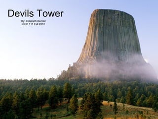
  • 1. Devils Tower By: Elizabeth Bender GEO 111 Fall 2012
  • 2. Devils Tower Warning: Notice is hereby given that any person or persons who injure or destroy or, without specific authority from the Secretary of the Interior, excavate or appropriate any historic or prehistoric ruin, monument, object of antiquity, or of scientific interest, for the protection of which this reservation was created, will be subject to arrest and punishment under the provisions of the acts of Congress approved February 6, 1905, and Jun 8,1908.
  • 3. The Basics Approximately 300 miles north of Cheyenne, Wyoming, lies American's first National Monument.
  • 4. The Basics It stands 1,270 feet above the Belle Fourche River below, and measures 180 feet east to west and 300 feet north to south.
  • 5. The neighborhood There are three named layers of sedimentary rocks exposed at the base of Devils Tower.
  • 6. The neighborhood The oldest layer at the bottom is called the Spearfish Formation, named after the town Spearfish, South Dakota. This layer was formed during the Triassic Epoch approximately 240 million years ago, when most of the surrounding area was part of the sea. The composition of the Spearfish Formation includes mudstones and sandstones.
  • 7. The neighborhood The middle layer is known as the Gypsum Springs Formation and is mostly gypsum. It was formed during the Jurassic Epoch 150 million years ago. Gypsum is formed in natural saline waters.
  • 8. The neighborhood The final layer of Devils Tower is the Sundance Formation. This is the youngest formation of the monolith, forming relatively shortly after the Gypsum Springs Formation. The layer is named after the Sundance Sea in which it was deposited and ripple marks from receding water can still be seen within this layer.
  • 9. Formation Devil's Tower is an igneous rock formation created by intrusion. Igneous intrusion occurs when magma solidifies before it breaks through Earth's crust. The layer above the intrusion is pushed skyward creating, in this case, a massive bulge under the sedimentary rock crust. As the magma cooled, it shrank it size, forming the four, five, six, even seven sided pillars of Devils Tower. As the continents shifted and water eroded away the sedimentary layers, the phonolitic porphyry monolithic pluton was exposed. Geologist believe that while Devils Tower formed from cooling magma 50 million years ago during the Eocene Epoch, but it was not exposed until 1-2 million years ago.
  • 10. Additional Research Needed Other theories state that Devils Tower is a laccolith or a volcanic neck. Geologists argue that Devils Tower would be much larger than it is if it were a laccolith, and there is no evidence of volcanic activities in the last 50 million years in the area. Click to watch
  • 11. Weathering & Erosion 101 The 1,000 feet of sedimentary layers have eroded over the last 1-2 million years exposing the much harder igneous rock below. Some layers washed away with the receding Sundance Sea. Water of the Belle Fourche River Valley have washed away the loose soil and the eroded debris from the damaging rain and snow. Erosion exposed the monolith as it stands today. Frost wedging continues to break off small pieces that are swept away by water, wind, or people.
  • 12. Erosion of Arid Land Wyoming, though once a body of water, is now a relatively arid land. The base of Devils Tower shows evidence of differential weathering and erosion. The sedimentary layers remaining at the base have eroded much faster than the igneous rock tower above. This has created the different slope and the dramatic distinction between the two types. The obviousness of the impressive change between the igneous and sedimentary layers is due to the arid climate of Wyoming.
  • 13. Erosion of Arid Land The wind has also affected areas of Devils Tower. The monolith and surrounding areas are subject to deflation and abrasion. Dry particles are blown away, in deflation, and deposited miles away. Sands that are swept away don't leave without abrading the solid surfaces. These Aeolian processes are not as destructive as water, but signs Click to are prevalent at Devils Tower watch and evidence can be found in the surrounding areas of Aeolian deposited particles.
  • 14. Very Brief Human Geography Before it was named a national monument, Devils Tower was believed to be formed by the claws of a giant bear as it was chasing two girls of the native Crow Tribe. A spirit made the rock grow until the bear could no longer reach them. 1906 FDR made Devils Tower America’s first national monument.
  • 15. Very Brief Human Geography In 1977, Steven Spielberg directed “Close Encounters of the Third Kind,” a movie about UFOs and supernatural activities surrounding the monolith.