2013 ATLANTIC BASIN HURRICANE SEASON 1 June – 30 December
•Descargar como PPT, PDF•
0 recomendaciones•973 vistas

2013 ATLANTIC BASIN HURRICANE SEASON June 1 – December 30. REASONS FOR A SLOWLY DEVELOPING SEASON. "A large area of high pressure over the central Atlantic has been very strong and very good at driving dry air southward into the tropics into September. Generally it is easier for tropical storms to form and tropical storms to streng-then into hurricanes when an un-obstructed supply of moisture available Tropical Storm Karen ---Elventh Storm Of 2013 Season. Expected to be a rainmaker in the USA. Presentation courtesy of Dr Walter Hays, Global Alliance for Disaster Reduction

Recomendados
Más contenido relacionado
La actualidad más candente
La actualidad más candente (20)
Destacado
Destacado (20)
Similar a 2013 ATLANTIC BASIN HURRICANE SEASON 1 June – 30 December
Similar a 2013 ATLANTIC BASIN HURRICANE SEASON 1 June – 30 December (20)
Más de Professor Eric K. Noji, M.D., MPH, DTMH(Lon), FRCP(UK)hon
Más de Professor Eric K. Noji, M.D., MPH, DTMH(Lon), FRCP(UK)hon (20)
Último
Último (20)
2013 ATLANTIC BASIN HURRICANE SEASON 1 June – 30 December
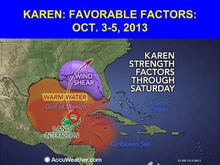
- 1. KAREN: FAVORABLE FACTORS: OCT. 3-5, 2013
- 2. 2013 ATLANTIC BASIN HURRICANE SEASON June 1 – December 30
- 3. OVER 100 YEARS OF HISTORY: ATLANTIC AND PACIFIC BASINS
- 4. COMMUNITYCOMMUNITY DATA BASESDATA BASES AND INFORMATIONAND INFORMATION •SEVERE WINDSTORMS •INVENTORY •VULNERABILITY •LOCATION RISK ASSESSMENTRISK ASSESSMENT RISK ACCEPTABLE RISK UNACCEPTABLE RISK SEVERE WINDSTORMSEVERE WINDSTORM DISASTER RESILIENCEDISASTER RESILIENCE •PREPAREDNESS •PROTECTION •EARLY WARNING •EMERGENCY RESPONSE •RECOVERY and RECONSTRUCTION POLICY OPTIONSPOLICY OPTIONS Wind profileWind profile Storm Hazards:Storm Hazards: -Wind pressure -Surge -Rain -Flood -Waves -Salt water -Missiles -Tornadoes OceanOcean Gradient WindGradient Wind
- 5. PRE-SEASON FORECAST OF THE NATIONAL OCEANIC AND ATMOSPHERIC ADMINISTRATION FORECAST: 13-20 NAMED STORMS WITH 7-10 BECOMING HURRICANES
- 7. CHRONOLOGY OF 2013’s STORMS • ANDREA - Tropical Storm; June 5 • BARRY - Tropical Storm; June 19 • CHANTAL – Tropical Storm; July 7 • DORIAN – Tropical Storm; July 22 • ERIN – Tropical Storm; August 14 • FERNAND –Trop. Storm; August 16 • GABRIELLE – Trop. Storm; Aug. 25
- 8. CHRONOLOGY OF 2013’S STORMS • HUMBERTO – Hurricane; Sept 10 • INGRID – Hurricane; Sept. 13 • JERRY – Tropical storm; Sept. 30 • KAREN – Tropical storm; Oct. 3 • LORENZO – • MELISSA – • NESTOR –
- 9. CHRONOLOGY OF 2013’S STORMS • OLGA – • PABLO – • REBEKAH – • SEBASTIEN – • TANYA – • VAN -- • WENDY --
- 10. STORM TRACKS OF ANDREA, BARRY, CHANTAL, AND DORIAN
- 11. TROPICAL STORM ANDREA --- FIRST STORM OF 2013 SEASON A Rain Maker
- 12. ANDREA: JUNE 5, 2013
- 13. ANDREA’S IMPACTS • The precursor to Andrea dropped nearly 12 inches (300 mm) of rainfall in the Yucatán Peninsula. • In Cuba, the storm brought flooding, especially in the Pinar del Rio Province, and over 1,000 people fled their homes, mainly along the Cuyaguateje River. .
- 14. ANDREA’S IMPACTS • In Florida, the storm brought heavy rainfall that caused localized flooding and five tornadoes that downed power lines and trees and caused significant roof damage. • As Andrea died, heavy rains occurred in the Eastern United States and Atlantic Canada, causing flooding in Nova Scotia. • .
- 15. TROPICAL STORM BARRY --- SECOND STORM OF 2013 SEASON A Rain Maker and Power Disupter
- 16. BARRY: JUNE 19, 2013
- 17. BARRY’S IMPACTS • In the Mexican state of Yucatan, wind gusted up to 48 mph (77 km/h) and heavy rains downed trees and power lines; more than 26,000 residents lost power after lightning struck a nearby power station and caused a fire. • El Salvador experienced flooding.
- 18. BARRY’S IMPACTS • Heavy rains in Honduras triggered flooding that damaged 60 homes and affected 300 people. • In southern Belize, an estimated 10 in (250 mm) of rain fell in 24 hours, causing several rivers to over-top their banks and some to evacuate.]
- 19. TROPICAL STORM CHANTAL --- THIRD STORM OF 2013 SEASON A Rain Maker
- 20. TROPICAL STORM CHANTAL: JULY 8, 2013
- 21. A tropical storm warning was issued for Puerto Rico, Barbados, Dominica, Saint Lucia, Martinique, Guadeloupe, and Miami. July 8th
- 22. CHANTAL’S IMPACTS • Chantal produced heavy rainfall in Hispaniola, forcing thousands to evacuate their homes. • In the Dominican Republic, flooding from the storm killed one person in Maimon.1]
- 23. TROPICAL STORM DORIAN --- FOURTH STORM OF 2013 SEASON Rain in florida was Most Notable Impact
- 24. DORIAN
- 25. TROPICAL STORM ERIN --- FIFTH STORM OF 2013 SEASON A Short Lived Storm With no Notable Impact
- 27. TROPICAL STORM FERDNAND --- SIXTH STORM OF 2013 SEASON Tropical Storm Ferdnand brought heavy rainfall near Veracruz, killing fourteen
- 29. AUGUST 16th REVISED FORECAST OF THE NATIONAL OCEANIC AND ATMOSPHERIC ADMINISTRATION FORECAST: STILL AN ABOVE NOMAL SEASON, BUT ONLY 3 TO 5 MAJOR HURRICANES
- 30. TROPICAL STORM GABRIELLE --- SEVENTH STORM OF 2013 SEASON No Notable Impacts
- 31. GABRIELLE
- 32. ACTUAL STORM TRACKS AS OF SEPTEMBER 15, 2013
- 33. SEPTEMBER 9th “2013 SEASON MAY GO IN THE RECORD BOOKS AS A “DUD””
- 34. REASONS FOR A SLOWLY DEVELOPING SEASON
- 35. REASONS FOR A SLOWLY DEVELOPING SEASON • "A large area of high pressure over the central Atlantic has been very strong and very good at driving dry air southward into the tropics into September." • Generally it is easier for tropical storms to form and tropical storms to streng- then into hurricanes when an un- obstructed supply of moisture available
- 36. REASONS FOR A SLOWLY DEVELOPING SEASON • Frequent surges of wind shear [disruptive winds at mid-levels of the atmosphere] have occurred during the 2013 season. • Wind shear tends to disrupt the circulation around a developing system, shearing off the top of the system or causing it to be very lop- sided.
- 37. TROPICAL STORM HUMBERTO --- EIGHTH STORM OF 2013 SEASON Became Season’s 1st Hurricane DISSIPATED QUICKLY DUE TO VERTICAL SHEAR IN ATMOSPHERE
- 39. TROPICAL STORM INGRID --- NINTH STORM OF 2013 SEASON Became Season’s 2nd Hurricane September 13 A RAINMAKER IN MEXICO THAT CAUSED DEATHS
- 40. INGRID: NEADED FOR MEXICO SEPTEMBER 13, 2013
- 41. TROPICAL STORM JERRY --- TENTH STORM OF 2013 SEASON September 30 DIED BEFORE IT COULD DO ANYTHING
- 42. TROPICAL STORM KAREN --- ELVENTH STORM OF 2013 SEASON October 3 EXPECTED TO BE A RAINMAKER IN THE USA
- 43. KAREN: HEADED FOR USA LANDFALL: OCT. 3, 2013
- 44. KAREN: FAVORABLE FACTORS: OCT. 3-5, 2013
- 45. LOOKING BACK AT 2012
- 46. 2012’s ACTUAL STORMS EXCEEDED THE FORECAST FORECAST: 15 NAMED STORMS WITH 4-8 BECOMING HURRICANES
- 47. ACTUAL: TWENTY NAMED STORMS; 10 HURRICANES
- 48. NAMED STORMS IN 2012 • ALBERTO - Tropical storm; May 19 • BERYL - Tropical storm; May 27 • CHRIS – Hurricane; June 21 • DEBBY – Tropical storm; June 23 • ERNESTO –Hurricane; Aug 3 • FLORENCE –Tropical storm: Aug 5 • GORDON –Hurricane, August 16
- 49. NAMED STORMS FOR 2012 • HELENE –Tropical Storm, Aug. 19 • ISAAC – Hurricane, August 21 • JOYCE –Tropical Storm, Aug. 25 • KIRK –Tropical Storm. Aug. 27 • LESLIE –Hurricane, Sept. 5 • MICHAEL –Hurricane, Sept. 5 • NADINE – Hurricane, Sept. 12
- 50. NAMED STORMS IN 2012 • OSCAR – Tropical Storm; Oct. 4 • PATTY – Tropical Storm; Oct. 11 • RAFAEL – Hurricane; October 12 • SANDY– A Super Hurricane; October 22 • TONY – Tropical Storm; Oct. 24
- 51. SANDY: A $300 BILLION STORM; OCTOBER 24, 2012 Sandy, 2012’s ninth hurricane, became a huge storm with wind and rain bands reaching out 500 km or more from the storm center, producing 15-50 cm of rain and flooding in Jamaica, Bermuda, Haiti, Dominican Republic, Cuba, New Jersey, and New York
- 52. CAT I HURRICANE SANDY: OCTOBER 24
- 53. SUPER STORM SANDY: OCT. 29-30, 2012
- 54. SANDY: RAIN IN HAITI
- 55. SANDY: RAIN IN CUBA
- 56. NEW JERSEY: ATLANTIC CITY UNDER WATER
- 57. NEW JERSEY: OCEAN FRONT FLOODING
- 60. $360 MILLION STORM SURGE, NEW HAVEN, CT: OCT. 30