Geographical profile of middle east
•
3 recomendaciones•3,126 vistas

Geographical Profile of Middle East

Recomendados
Más contenido relacionado
Destacado
Destacado (16)
Más de Mohamad Abd Rabbo
Más de Mohamad Abd Rabbo (12)
Último
Último (20)
Geographical profile of middle east
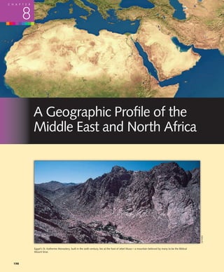
- 1. C H A P T E R 8 A Geographic Profile of the Middle East and North Africa Joe Hobbs Egypt’s St. Katherine Monastery, built in the sixth century, lies at the foot of Jebel Musa—a mountain believed by many to be the Biblical Mount Sinai. 198
- 2. Section 8.1 Area and Population 199 chapter outline 8.1 Area and Population 8.4 Economic Geography 8.2 Physical Geography and Human Adaptations 8.5 Geopolitical Issues 8.3 Cultural and Historical Geographies chapter objectives This chapter should enable you to: Appreciate the problems of control over fresh water in this arid region Understand and explain the mostly beneficial relationships be- tween villagers, pastoral nomads, and city dwellers in an envi- Know what al-Qa’ida and other Islamist terrorist groups are ronmentally challenging region and what they want Know the basic beliefs and sacred places of Jews, Christians, and Muslims Recognize the importance of petroleum to this region and the Look for this logo in the text and go to GeographyNow at world economy http://earthscience.brookscole.com/wrg5e to explore interactive Identify the geographic chokepoints and oil pipelines that are maps, view animations, sharpen your factual knowledge and among the world’s most strategically important places and geographic literacy, and test your critical thinking and analytical routes skills with unique interactive resources. he Middle East is a fitting designation for the places Africa more intelligible by illuminating the geographic con- T and the cultures of this vital world region because they are literally in the middle. This is a physical cross- roads, where the continents of Africa, Asia, and Europe meet text within which they occur. and the waters of the Mediterranean Sea and the Indian Ocean mingle. Its peoples—Arab, Jew, Persian, Turk, Kurd, 8.1 Area and Population Berber, and others— express in their cultures and ethnicities What is the Middle East and where is it? The term itself is the coming together of these diverse influences. Occupying as Eurocentric, created by the British who placed themselves in they do this strategic location, the nations of the Middle East the figurative center of the world. They began to use the term and North Africa have through five millennia been unwilling prior to the outbreak of World War I, when the Near East re- hosts to occupiers and empires originating far beyond their ferred to the territories of the Ottoman Empire in the Eastern borders. They have also bestowed upon humankind a rich Mediterranean region, the East to India, and the Far East to legacy that includes the ancient civilizations of Egypt and China, Japan, and the western Pacific Rim. With Middle East, Mesopotamia and the world’s three great monotheistic faiths they designated as a separate region the countries around the of Judaism, Christianity, and Islam. Persian Gulf (known to Arabs as the Arabian Gulf, and in People outside the region tend to forget about such con- this text as the Persian /Arabian Gulf and simply The Gulf). tributions because they associate the Middle East and North Gradually, the perceived boundaries of the region grew. Africa with war and terrorism. These negative connotations Sources today vary widely in their interpretation of are often accompanied by muddled understanding. This is which countries are in the Middle East. For some, the perhaps the most inaccurately perceived region in the world. Middle East includes only the countries clustered around the Does sand cover most of the area? Are there camels every- Arabian Peninsula. For others, it spans a vast 6,000 miles where? Does everyone speak Arabic? Are Turks and Persians (9,700 km) west to east from Morocco in northwest Africa Arabs? Are all Arabs Muslims? The answer to each of these to Afghanistan in central Asia, and a north–south distance questions is no, yet popular Western media suggest other- of about 3,000 miles (4,800 km) from Turkey, on Europe’s wise. This and the following chapter attempt to make the southeastern corner, to Sudan, which adjoins East Africa misunderstood, complex, sometimes bloody, but often hope- (Figure 8.1). This is the region covered in these chapters, ful events and circumstances in the Middle East and North where it is referred to as “The Middle East and North
- 3. 200 Chapter 8 A Geographic Profile of the Middle East and North Africa Political Geography 15˚W ROMANIA C UZBEKISTAN . R U S S I A I T TAJIKISTAN RT as SPAIN PO pi ATLANTIC Black Sea A BULG. GEORGIA an L Y ALB. TURKMENISTAN 30˚ ARM. AZER. N O C E A N M E D Sea Algiers IT Kabul Ankara G N Rabat E R T U R K E Y T A C O Tunis A F G H A N I S TA N E R C Tehran E TUNISIA C R R O A E N I S O E A CYPRUS SYRIA M I R A N Tro Tripoli N LEBANON Beirut Damascus Baghdad A S E A K Canpic of R HA I R A Q cer SA ISRAEL Jerusalem A A L G E R I A RN Amman P E KUWAIT Kuwait ST JORDAN Cairo er WE P 20˚ sia N BAHRAIN n Gu L I B Y A S A U D I lf Abu Doha Dhabi Muscat MAURITANIA Riyadh QATAR E G Y P T U.A.E. 20˚N R e N A R A B I A A d SENEGAL M A L I M A r a b i a n S O e N I G E R S e a a N G U E IN San’a M B U R K I N A FA S O EA C H A D Khartoum ERITREA E S.L. Y 10˚N I N IVORY S U D A N LI T O G O DJIBOUTI B B E N E COAST N I G E R I A R GHANA IA A ON I E T H I O P I A I N D I A N L Equa C E N T R A L O tor A R A F R I C A N R E P. 0˚ O C E A N E M 0 500 1000 mi. M A or C O Equat 0 500 1000 km. S 60˚E Figure 8.1 The Middle East and North Africa Africa.” The North African peoples of Morocco, Algeria, Egypt has the Nile River, and parts of Iran and Turkey have and Tunisia generally do not perceive themselves as Middle bountiful rain and snow. Conversely, where rain seldom Easterners; they are, rather, from what they call the Maghreb, falls, as in the Sahara of North Africa and in the Arabian meaning “the western land.” Many geographers would place Peninsula, people are few. Sudan in Africa South of the Sahara and Afghanistan in ei- The Middle East and North Africa as a whole have a high ther Central Asia or South Asia. Both are clearly border or rate of population growth. The rapid growth is a general in- transitional countries in regional terms, and in this text, they are placed in the Middle East and North Africa with consid- eration given to their characteristics of the other regions. Thus defined, the Middle East and North Africa include 21 countries, the Palestinian territories of the West Bank and Gaza Strip, and the disputed Western Sahara (Table 8.1), occupying 5.91 million square miles (15.32 million sq km) 30˚ N and inhabited by about 479 million people as of mid-2004. This area is about 1.8 times the size of the lower 48 United States and is generally situated at latitudes equivalent to ic of Tropncer Ca those between Boston, Massachusetts, and Bogotá, Colom- bia (Figure 8.2). These nearly half-billion people are not distributed evenly across the region but are concentrated in major clusters (Fig- ures 8.3a and b). Three countries contain the lion’s share of the region’s population: Turkey, Iran, and Egypt, each with Equa to r more than 65 million people. One look at a map of precipi- tation or vegetation explains why people are clustered this way (see Figure 2.1, page 18, and Figures 8.5a and b). Where Figure 8.2 The Middle East and North Africa compared in water is abundant in this generally arid region, so are people. latitude and area with the conterminous United States
- 4. Section 8.1 Area and Population 201 Table 8.1 The Middle East and North Africa: Basic Data Estimated Area Annual Rate Population Human Urban Per Estimated of Natural Density Develop- Popula- Arable Capita (thousand/ (thousand/ Population Increase ment tion Land GDP PPP Political Unit sq mi) sq km) (millions) (%) (sq mi) (sq km) Index (%) (%) ($U.S.) Middle East Afghanistan 251.8 652.2 28.5 2.7 113 44 N/A 22 12 700 Bahrain 0.3 0.8 0.7 1.7 2333 901 0.843 87 3 16,900 Iran 630.6 1633.3 67.4 1.2 107 41 0.732 67 8 7000 Iraq 169.2 438.2 25.9 2.7 153 59 N/A 68 13 1500 Israel 8.1 21.0 6.8 1.6 840 324 0.908 92 16 19,800 Jordan 34.4 89.1 5.6 2.4 163 63 0.750 79 2 4300 Kuwait 6.9 17.9 2.5 1.7 362 140 0.838 100 1 19,000 Lebanon 4 10.4 4.5 1.7 1125 434 0.758 87 16 4800 Oman 82 212.4 2.7 2.2 33 13 0.770 76 0 13,100 Palestinian Territories 2.4 6.2 3.8 3.5 1583 611 0.726 57 17 800 Qatar 4.2 10.9 0.7 1.6 167 64 0.833 92 1 21,500 Saudi Arabia 830 2149.7 25.1 3.0 30 12 0.768 86 1 11,800 Syria 71.5 185.2 18 2.4 252 97 0.710 50 25 3300 Turkey 299.2 774.9 71.3 1.4 238 92 0.751 59 31 6700 United Arab Emirates 32.3 83.7 4.2 1.4 130 50 0.824 78 0 23,200 Yemen 203.8 527.8 20 3.3 98 38 0.482 26 2 800 Total 2630.7 6813.5 287.7 2.0 207 80 0.728 60 8 6153 North Africa Algeria 919.6 2381.8 32.3 1.5 35 14 0.704 49 3 6000 Egypt 386.7 1001.6 73.4 2.0 190 73 0.653 43 3 4000 Libya 679.4 1759.6 5.6 2.4 8 3 0.794 86 1 6400 Morocco 172.4 446.5 30.6 1.5 177 69 0.620 57 19 4000 Sudan 967.5 2505.8 39.1 2.8 40 16 0.505 31 7 1900 Tunisia 63.2 163.7 10 1.1 158 61 0.745 63 18 6900 Western Sahara 97.2 251.7 0.3 2.1 3 1 N/A 0 0 N/A Total 3286 8510.7 191.3 1.9 123 47 0.634 46 5 4130 Summary Total 5916.7 15,324.2 479 1.9 160 62 0.690 54 6 5345 Source:World Population Data Sheet, Population Reference Bureau, 2004; U.N.Human Development Report, United Nations,2004; World Factbook, CIA,2004. dication that this is a developing rather than industrialized such rapid growth may be ascribed in large part to the Pales- region and also reflects the majority Muslim culture that fa- tinians’ poverty and perhaps to the wishes of many Palestini- vors larger families. The average annual rate of population ans to have more children to counterbalance the demo- change for the 21 countries, the Palestinian territories, and graphic weight of their perceived Israeli foe. Western Sahara was 1.9 percent in 2004. The lowest rate of Between these extremes are countries with modest rates population growth (1.1 percent) is in Tunisia. The highest is of population growth of 1.5 to 2 percent per year; these in- 3.5 percent in the Palestinian territories, followed closely by clude Israel, Morocco, Algeria, Bahrain, Kuwait, Lebanon, 3.3 percent in Yemen. These are some of the highest popula- and Qatar. Generally, their governments have regarded most tion growth rates in the world. In the Palestinian territories, of these countries as too populous for their resource and
- 5. 202 Chapter 8 A Geographic Profile of the Middle East and North Africa Population Distribution of the Middle East and North Africa 15˚W 30˚ N Tro Canpic of cer 20˚ N 20˚N POPULATION DENSITY sq. km. sq. mi. 10˚N 100> 259> 10–99 26–258 1–9 2–25 <1 <2 or Equat 60˚E (a) Population Cartogram of the Middle East and North Africa This sized box equals one million people TURKEY AFGHANISTAN LEBANON IRAN SYRIA IRAQ West Bank ISRAEL JORDAN Gaza Strip KUWAIT TUNISIA SAUDI ARABIA BAHRAIN ALGERIA QATAR MOROCCO LIBYA EGYPT U.A.E. YEMEN OMAN Western Sahara SUDAN Figure 8.3 (a) Population distribution and (b) population cartogram of the Middle East (b) and North Africa industrial base and have encouraged family planning. They dent on subsistence agriculture and have low percentages of have been successful in lowering birth rates. On the other urban inhabitants. Perhaps surprisingly, however, the Middle hand, oil-rich Saudi Arabia, with its 3 percent annual growth East and North Africa have more urbanites than country rate, is a good example of how rapid population growth is folk. The average urban population among the 23 countries not always a sign of poverty, particularly in this region. In this and territories is 54 percent. The most prosperous countries case, an oil-rich nation has encouraged its citizens to create are also the most urban. Essentially a city-state, Kuwait is more citizens so that in the future they will not need to im- 100 percent urban. The other oil-wealthy Arab Gulf coun- port foreign laborers and technicians and will be more self- tries also have urban populations over 70 percent. Consis- sufficient in their development. tent with its profile as a Western-style industrialized country Many developing countries have economies largely depen- without oil resources, Israel is 92 percent urban. At the other
- 6. Section 8.2 Physical Geography and Human Adaptations 203 end of the spectrum, desperately poor Afghanistan, Yemen, amount too small for most types of dry farming (unirrigated and Sudan have urban populations of less than 32 percent. agriculture). Sometimes, however, localized cloudbursts re- lease moisture that allows plants, animals, and small popu- lations of people—the Bedouin, Tuareg, and other pastoral 8.2 Physical Geography nomads—to live in the desert. Even the vast Sahara, the world’s largest desert, supports a surprising diversity and and Human Adaptations abundance of life. Plants, animals, and even people have The margins of the Middle East and North Africa are mainly developed strategies of drought avoidance and drought en- oceans, seas, high mountains, and deserts (Figure 8.4). To durance to live in this harsh biome. Plants either avoid the west lies the Atlantic Ocean; to the south, the Sahara and drought by completing their life cycle quickly wherever rain the highlands of East Africa; to the north, the Mediterranean, has fallen or endure drought by using their extensive root Black, and Caspian Seas, together with mountains and systems, small leaves, and other adaptations to take advan- deserts lining the southern land frontiers of Russia and the tage of subsurface or atmospheric moisture. Animals endure Near Abroad; and to the east, the Hindu Kush mountains on drought by calling on extraordinary physical abilities (for the Afghanistan–Pakistan frontier and the Baluchistan example, a camel can sweat away a third of its body weight Desert straddling Iran and Pakistan. The land is composed and still live) or by avoiding the worst conditions by being mainly of arid plains and plateaus, together with large areas active only at night or by migrating from one moist place to of rugged mountains and isolated “seas” of sand. Despite the another. Migration to avoid drought is also the strategy pas- environmental challenges, this region has given rise to some toral nomads use. Populations of people, plants, and animals of the world’s oldest and most influential ways of living. are all but nonexistent in the region’s vast sand seas, includ- ing the Great Sand Sea of western Egypt (Figure 8.6) and the Hot, Dry, and Barren but, Empty Quarter of the Arabian Peninsula. in Places, Damp and Forested The region’s climates have the comparatively large daily Aridity dominates the Middle East and North Africa (Fig- and seasonal ranges of temperature characteristic of dry ures 8.5a and b). At least three-fourths of the region has av- lands. Desert nights can be surprisingly cool. Most days erage yearly precipitation of less than 10 inches (25 cm), an and nights are cloudless, so the heat absorbed on the desert Physical Geography of the Middle East and North Africa 15˚W C as pi ATLANTIC Black Sea SH an 30˚ N O C E A N M E D Mt s. KU Sea ic U IT A N ATO L I A N Po nt D E P L AT E A U Mts. IN rus ts . El Ta u H burz M R t a i n s M o u n R A Tigr l a s Za A t N g RT ro P L A T E A U O F is R. E A SE Registan s DE Tro N M S E A ou I R A N IAN Canpic of Eu p A cer hr nt SYR a te s R. ain s s- El H ar Qattara AN-NAFUD er Su S ug P sia m 20˚ el Depression DESERT A As n Gu m N ue an Ta n e z ro u f t lf H d Al G. of Oman Pl A A h a g g a r Great Sand Sea N at Ha ea jar ile R u M ts 20˚N R. A M t s . . R e WESTERN A R A B I A N D DESERT E S RUB AL-KHALI d Re E R T P E N I N S U L A A A r a b i a n d s ir Se S a e S e a M Hi a ts ll . s s. en Blu Mt Ad Socotra 10˚N eN a of ile R rr f ul le R. ELEVATION Ma . G i te N i meters feet meters feet I N D I A N Wh 5000> 16400> 250–500 820–1640 S 2500–5000 8200–16400 0–250 0–820 u d O C E A N Equa tor d 1000–2500 3280–8200 0˚ <0 <0 0 500 1000 mi. 500–1000 1640–3280 0 500 1000 km. Figure 8.4 Reference map of the topographic features, deserts, and seas of the Middle East and North Africa
- 7. 204 Chapter 8 A Geographic Profile of the Middle East and North Africa Climates of the Middle East and Biomes of the Middle East and North Africa North Africa 30 30˚ ˚N N 20˚N 20˚N 10˚N 10˚N Equ Equa ator tor CLIMATE TYPES 0˚ 60˚E BIOME TYPES 0˚ 60˚E Humid subtropical Semiarid / steppe Tropical savanna Mediterranean Temperate mixed forests Savanna Mediterranean Desert Undifferentiated highland Prairie and steppe Coniferous forests Desert and desert shrub Undifferentiated highland (a) (b) Figure 8.5 (a) Climates and (b) biomes of the Middle East and North Africa surface during the day is lost by radiational cooling to the Cairo and other hot inland locations. In Saudi Arabia, the heights of the atmosphere at night. Summers in the lowlands government relocates from Riyadh to the highland summer are very hot almost everywhere. The hottest shade tempera- capital of Taif to escape the lowland furnace. ture ever recorded on Earth, 136ЊF (58ЊC), occurred in Libya Lower winter temperatures bring relief from the summer in September 1922. Many places regularly experience daily heat, and the more favored places receive enough precipita- maximum temperatures over 100ЊF (38ЊC) for weeks at a tion for dry farming of winter wheat, barley, and other cool- time. season crops (Figure 8.7). In general, winters are cool to Human settlements located near the sand seas often expe- mild. But very cold winters and snowfalls occur in the high rience the unpleasant combination of high temperatures and interior basins and plateaus of Iran, Afghanistan, and Tur- hot, sand-laden winds, creating the sandstorms known lo- key. These locales generally have a steppe climate. Only in cally by such names as simuum (“poison”) and sirocco. Only the southernmost reaches of the region, notably Sudan, do in mountainous sections and in some places near the sea do temperatures remain consistently high throughout the year. higher elevations or sea breezes temper the intense midsum- A savanna climate and biome prevail there. mer heat. The population of Alexandria, on the Mediter- Most areas bordering the Mediterranean Sea have 15 to ranean Sea coast, explodes in summer as Egyptians flee from 40 inches (38 to 102 cm) of precipitation a year, falling al- Agricultural Land Use 30˚ N 20˚N 10˚N Equa tor LAND USE TYPES Joe Hobbs 0˚ 60˚E Mediterranean farming Subsistence agriculture Mixed subsistence Specialized horticulture Shifting cultivation Grazing and stock rearing Figure 8.6 Sand “seas” cover large areas in Saudi Arabia, Iran, Nomadic herding Little agricultural activity and parts of the Sahara. This is the edge of the Great Sand Sea near Siwa Oasis in Egypt’s Western Desert. Figure 8.7 Land use in the Middle East and North Africa
- 8. Section 8.2 Physical Geography and Human Adaptations 205 most exclusively in winter, while the summer is dry and warm—a typical Mediterranean climate pattern. Through- out history, people without access to perennial streams have stored this moisture to make it available later for growing crops that require the higher temperatures of the summer months. The Nabateans, for example, who were contempo- raries of the Romans in what is now Jordan, had a sophisti- cated network of limestone cisterns and irrigation channels (Figure 8.8). Rainfall sufficient for dry farming during the summer is concentrated in areas along the southern and northern margins of the region. The Black Sea side of Tur- key’s Pontic (also known as Kuzey) Mountains is lush and moist in the summer, and tea grows well there (Figure 8.9). In the southwestern Arabian Peninsula, a monsoonal climate brings summer rainfall and autumn harvests to Yemen and Joe Hobbs Figure 8.9 Rainfall is heavy on the Black Sea side of Turkey’s Pontic (Kuzey) Mountains. Note that roofs are pitched to shed precipitation; in the region’s drier areas, most roofs are flat. The crop growing here is corn. Oman, probably accounting for the Roman name for the area: Arabia Felix, or “Happy Arabia.” Mountainous areas in the region, like the river valleys and the margins of the Mediterranean, play a vital role in sup- porting human populations and national economies. Due to orographic or elevation-induced precipitation, the moun- tains tend to receive much more rainfall than surrounding lowland areas. There are three principal mountainous regions of the Middle East and North Africa (see Figure 8.4). In north- western Africa between the Mediterranean Sea and the Sa- hara, the Atlas Mountains of Morocco, Algeria, and Tunisia reach over 13,000 feet (3,965 m) in elevation. Mountains Joe Hobbs also rise on both sides of the Red Sea, with peaks up to 12,336 feet (3,760 m) in Yemen. These are the result of tec- Figure 8.8 The Treasury, a temple carved in red sandstone, tonic processes that are pulling the African and Arabian probably in the first century A.D., by the Nabateans at their plates apart, creating the northern part of the Great Rift Val- F2.9 capital of Petra in southern Jordan. English poet Dean Burgen called Petra “A Rose Red City, Half as Old as Time.” The ley. The hinge of this crustal movement is the Bekaa Valley of 26 Nabateans built sophisticated networks for water storage and Lebanon, where the widening fault line follows the Jordan distribution. For scale, note the man at the lower right. River valley southward to the Dead Sea (Figure 8.10). This
- 9. 206 Chapter 8 A Geographic Profile of the Middle East and North Africa Joe Hobbs Joe Hobbs Figure 8.10 The surface of the Dead Sea is the lowest point on Figure 8.11 The Taurus Mountains of southeastern Turkey Earth, a consequence of the rifting of continental crust. valley is the deepest depression on Earth’s land surface, lying Extensive forests existed in early historical times in the about 600 feet (183 m) below sea level at Lake Kinneret (the Middle East and North Africa, particularly in these moun- Sea of Galilee or Lake Tiberius) and nearly 1,300 feet (400 tainous areas, but overcutting and overgrazing have almost m) below sea level at the shore of the Dead Sea, the lowest eliminated them. Since the dawn of civilization in this area, point on Earth. The rift then continues southward to the very around 3000 b.c., people have cut timber for construction deep Gulf of Aqaba and Red Sea before turning inland into and fuel faster than nature could replace it. Egyptian King Africa at Djibouti and Ethiopia. In tectonic processes, one Tutankhamen’s funerary shrines and Solomon’s Temple in consequence of rifting in one place is the subsequent collision Jerusalem were built of cedar of Lebanon. So prized has this of Earth’s crustal plates elsewhere. There are several such wood been through the millennia that only a few isolated collision zones in the Middle East and North Africa, partic- groves of cedar remain in Lebanon. Described in ancient ularly in Turkey and Iran, where mountain building has re- times as “an oasis of green with running creeks” and “a vast sulted. These are seismically active zones—meaning earth- forest whose branches hide the sky,” Lebanon is now largely quakes occur there—and rarely does a year go by without a barren (Figure 8.12). Lumber is still harvested commercially devastating quake rocking Turkey, Iran, or Afghanistan. in a few mountain areas such as the Atlas region of Morocco Click Geography Literacy to see an animation of divergent plate boundaries. A large area of mountains, including the region’s highest peaks, stretches across Turkey, Iran, and Afghanistan. These mountains are products of the collision of continental plates. On the eastern border with Pakistan, the Hindu Kush Range has peaks over 25,000 feet (7,600 m). The loftiest mountain ranges in Turkey are the Pontic, Taurus (Figure 8.11), and Anti-Taurus, and in Iran, the Elburz and Zagros Mountains. These chains radiate outward from the rugged Armenian Knot in the tangled border country where Turkey, Iran, and Joe Hobbs the countries of the Caucasus meet. Mt. Ararat is an extinct, glacier-covered volcano of 16,804 feet (5,122 m) towering over the border region between Turkey and Armenia. Many Figure 8.12 It was believed that the solar boat of King Cheops of Egypt (c. 2500 B.C.), builder of the Great Pyramid, would carry Biblical scholars and explorers think the ark of Noah lies the Pharoah’s spirit through the firmament. It had to be made of high on the mountain (and some go in search of it), for in the the best wood— cedar of Lebanon. The solar boat was interred book of Genesis, this boat was said to have come to rest “in next to the pyramid, and now stands in a specially constructed the mountains of Ararat.” museum.