Data out, data in: the ALA and the Field Guide apps to Australian Fauna Project
•
1 recomendación•1,104 vistas

This talk was given in June 2013 at the Atlas of Living Australia Science Symposium, at CSIRO Discovery Centre in Canberra. The talk discussed a project being run by Museum Victoria to work with museum partners around Australia to develop field guide apps to animals found all around Australia. The text of the talk can be found at the end of the slides.

Recomendados
Recomendados
Más contenido relacionado
Similar a Data out, data in: the ALA and the Field Guide apps to Australian Fauna Project
Similar a Data out, data in: the ALA and the Field Guide apps to Australian Fauna Project (20)
Último
Último (20)
Data out, data in: the ALA and the Field Guide apps to Australian Fauna Project
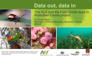
- 1. Data out, data in The ALA and the Field Guide apps to Australian Fauna project Dr Elycia Wallis, Manager, Online Collections, Museum Victoria @elyw Photo credits: Honeybrown Beetle Rodney Start/MV; Rainbow Lorikeet Steven Kuiter; Jewel Anemone Julian Finn/MV; Common Seadragon Mark Norman/MV
- 2. MV’s Field Guide to Victorian Fauna app
- 3. MV’s Field Guide to Victorian Fauna app • 700 - now 730 - species • Species profile descriptions • Distribution maps • Endangered status • Imagery •Audio calls
- 5. Collaborations and partnerships Bunurong Marine National Park Field Guide -with Parks Victoria iSpy Frogs -with Goulburn Broken Catchment Management Authority
- 6. Collaborations and partnerships Parks Connect Grand Canyon National Park Field Guide
- 7. Using the Field Guide app for museum programs Photo credits: MV Ornithology experts use the Field Guide app to teach the community about identifying birds.
- 8. User feedback via iTunes reviews and web comments Photo credit: Monarch Rodney Start/MV
- 9. Field Guide apps to Australian Fauna – by museums, for the community. Inspiring Australia, Unlocking Australia’s Potential Photo credits: Common Dolphin Mark Norman/MV
- 10. Western Australian Museum Museum & Art Gallery of the Northern Territory Queensland Museum Australian Museum Questacon Tasmanian Museum & Art Gallery South Australian Museum Museum Victoria Inspiring Australia Field Guide apps project Australia’s major natural history museums working together to make a field guide app for every state and territory in Australia
- 11. Inspiring Australia, Unlocking Australia’s Potential project deliverables Photo credits: Maori Octopus Mark Norman/MV • Six new free apps, for States and Territories around Australia, plus existing Victorian guide re-released • Android and Apple devices • Community engagement • Marketing strategy • Evaluation strategy
- 12. Inspiring Australia, Unlocking Australia’s Potential project planning • Port code to Android • Develop species master list 200 new species from each partner Check species names against ALA Preload taxonomic data, conservation status, maps from ALA Deliver completed species profile data back to ALA • Develop data repository to collate content • Partner museums write content, collect images and clear licenses • Code new app features • Compile and release each new app in two platforms
- 13. Achievements: code to Android Photo credits: Dr Elycia Wallis and Senator The Hon Don Farrell celebrate the release of the MV Field Guide app for Android devices. Jon Augier/MV
- 14. Achievements: data repository live
- 15. Using ALA web services to extract data
- 16. Issue: taxonomic name matching
- 17. using ALA data for field guide apps
- 18. Serving species profile data back to ALA
- 19. New functionality – citizen science My sightings log Image from http://www.mnh.si.edu/rc/fieldbooks/about.html Reporting sightings to ALA Ad hoc citizen science Social sharing
- 21. Field guides coming soon... Photo credits: Honeybrown Beetle Rodney Start/MV; Rainbow Lorikeet Steven Kuiter
- 22. SLIDE NOTES
- 23. Data Out, Data In: the ALA and the Field Guide Apps to Australian Fauna project. Dr Elycia Wallis, Museum Victoria This talk was given at the Atlas of Living Australia Science Symposium, 11-13 June 2013 What follows are the dot points I planned to cover in the talk. Title slide Today I will be talking about a different interaction with the ALA, where we are using and sharing back data; not for analysis but in a series of apps. Slide 2: MV’s Field Guide to Victorian Fauna app •Background to the project – MV’s field guide. •Released in 2011 with just over 700 species. Reused species profiles prepared for an Education product called Biodiversity Snapshots, which was developed in conjunction with the ALA and our State Education Department. •Done as an experimental project. •Source code also released. •Available for free on Apple platforms only – iPhone, iPod Touch, iPad •Very popular. Showcased to our peers at Museums and the Web and NDF conferences Slide 3: MV’s Field Guide to Victorian Fauna app The Field Guide app was designed to be just what it says – a field guide but with the addition of some features made possible by utilising an electronic platform. It was originally released with just over 700 species, and re-released a month or so ago with 730 species. Descriptions were written by MV scientists. Distribution maps were derived from specimen occurrence maps generated by museum datasets in OZCAM/ALA. Then edited by hand to remove spurious points (e.g. captive specimens) or where contractions or extensions of range aren’t reflected in the specimen occurrence data provided by museum collections. So the expert distribution maps now provided on various species are extremely welcome. Endangered status was derived by manually checking the DSE, EPBC and IUCN lists for each species. Images were sourced from MV’s collections, commissioned from various photographers, and licensed for use. Similarly, calls of frogs and birds were licensed for use from several external providers. Slide 4: 60,000+ downloads The original Field Guide has now been downloaded over 60,000 times and has maintained a consistent high rating in the app store. Data out, Data in. By Dr Elycia Wallis, Museum Victoria
- 24. Slide 5: Collaborations and Partnerships And with the source code released, several other organisations have now produced Field Guide apps. MV has been involved in the development of some of them. Slide 6: Collaborations and Partnerships And had no idea about the development of others. This is a new app, released just on Monday by folks in the US who have produced a field guide to the Grand Canyon. They first let us know about the development about a month ago when they asked for some help with minor bug fixes and have now released their app. And we know of 3 other organisations also doing the same thing, which is great, and which was entirely the point of sharing our code. Slide 7: Using the Field Guide app for Museum programs And the museum has started to use the field guide app in programs, such as the one pictured here where some of our ornithology staff are using it to assist with identifications during a BioScan down at Wilson’s Prom. Slide 8: User feedback via iTunes reviews and web comments But we’ve had consistent feedback from users, or would-be users, along two lines. When will it be coming out for Android devices? And when will similar guides come out for other States and Territories? Slide 9: Inspiring Australia, Unlocking Australia’s Potential So in 2012 we applied for, and were lucky enough to receive a substantial grant from the Federal Government under the Inspiring Australia, Unlocking Australia’s Potential grant scheme. This grant provides for a consortium of museums around Australia which hold Natural History Collections to prepare and publish Field Guide apps for States and Territories right around Australia. Slide 10: Inspiring Australia Field Guide apps project The museums who are the partners are shown here. Questacon is not contributing content but is where the Inspiring Australia coordinating team is based. Slide 11: Inspiring Australia, Unlocking Australia’s Potential project deliverables The deliverables for the project include: (see list on slide) Of these, today I’ll just touch on two in reference to the collaborative work we’re doing with the ALA. Slide 12: Inspiring Australia, Unlocking Australia’s Potential project planning (see words on slide for explanation) Data out, Data in. By Dr Elycia Wallis, Museum Victoria
- 25. Slide 13: Achievements: code to Android First significant milestone achieved was porting the code across to Android for release in the Google Play store. We decided that, rather than try to release the new code with one of the brand new apps, we would release it with the existing MV Field Guide. We were lucky that the Minister for Science and Research, Senator the Honorable Don Farrell was able to join us at Melbourne Museum to celebrate this first milestone in May. Slide 14: Achievements: data repository live The second significant milestone achieved is the release last week of the data repository. This is now live, though still (clearly) needs a bit of design polishing. It allows partners to bulk upload species content including images, review their content, add species profiles prepared by other states into their guide. The data repository contains two types of information – fixed and partner provided. The fixed data comes from the ALA, and the partner provided information includes the species profile information including images and sound files. Slide 15: Using ALA web services to extract data Just to demonstrate what I mean by getting fixed data from the ALA. As John La Salle demonstrated yesterday, species in ALA each have a species page. This contains information about valid name, classification (higher taxonomy), conservation status, and occurrence records heat map, as well as compiled distribution map for some species. We use web services to extract a number of pieces of data for species. The ALA has provided easy access to the web services on every species page. •Species name, •Classification, •Conservation status •Map Slide 16: Issues: taxonomic name matching I do just want to raise one or two issues, which I’ve also raised with ALA staff and where we will work together to find a solution. As I said, one of our key aims in the project is to link into the ALA with taxonomic data, and then to share back our species profile data. First task was to collate the species lists provided by each partner organisation. What we found was a whole lot of variation in names. Although I will talk about names found in ALA, what I want to emphasise is that the names in the ALA come from the Australian Faunal Directory, the master names list for Australian animal species. So we all need to work together to find names solutions. (continued next page) Data out, Data in. By Dr Elycia Wallis, Museum Victoria
- 26. Slide 16: Issues: taxonomic name matching continued We found partners provided species names with •spelling errors (easy to correct) •Junior synonyms where the ALA now has the recognised senior synonym (generally easy to recognise) •Senior synonyms where the ALA hasn’t yet caught up with a valid name change – more difficult. •A few newly described species that ALA doesn’t yet contain – more difficult. •For the occasional group, valid species names but the ALA doesn’t recognise them – really hard. Examples of barnacles and stinging jellies which have no listed species in ALA. What this means in practical terms is that we can’t draw data just from ALA, but neither can we share data back into ALA for those species. Like I say, it’s a work in progress and an issue we’ve only recently identified and will need to collaborate to fix. Slide 17: EcoLinc using ALA data for field guide apps One great thing about the interconnectedness of all these projects is the chance to share. Having made our source code freely available, others have set about making field guides of their own. And I thank Suzanne Clark (in the audience) from EcoLinc for sharing these screenshots. One field guide in production is by EcoLinc. EcoLinc provides programs focused on sustainable environmental education for students of all ages. They have been working on a project around Victoria’s Great Western Volcanic plains. One part has been the development of a field guide app. What I want to note is that they have also used maps from ALA for species included in their guides. Slide 18: Serving species profile data back to ALA In the end we will provide data back into the ALA. We have constructed a species profile that includes indentifying characters, biology, diet, habitat, distribution. Because of the ongoing, community requested developments that continue to be incorporated into ALA, when we approached Dave Martin to see how data could be fed back in, he was already working on a mechanism. The answer is the list function, shown here as an example for some of the Spongemaps morphology data provided by John Hooper at Queensland Museum. As you scroll along the window you’ll see the different character traits listed for each of the sponges. We’ll obviously have different columns in our data array, but it will be just the same principle. So we have a mechanism to get data out of ALA, and another to feed it back in. Data out, Data in. By Dr Elycia Wallis, Museum Victoria
- 27. Slide 19: New functionality: Citizen Science A number of new functions are planned for the app, mainly to provide users with ways to record their sightings, share their sightings on an ad hoc basis or share sightings on a methodical basis. Interestingly, our users aren’t asking for these features but people who want to incorporate the app into programs or projects they are planning are asking for them, so we’re looking at what to do. There are 3 proposed ways to incorporate sightings. •My sightings •Social sharing •To ALA. We don’t want to keep sightings data. Role of ad hoc sightings to be debated more. What to discuss: There are many pathways to sharing sightings with the ALA, this will form just one more. Already in existence is the ALA’s own app There are two considerations in particular we are giving to sharing sightings: whether having to login to ALA will put people off the photo issue. Will having a photo be required in order to upload the sighting. Or can we do like iNaturalist and rate the quality of the observation by a number of criteria, one of which is having a photo. Slide 20: EcoLinc Submit a sighting Remembering EcoLinc’s project to create an app – one of the new features they’ve added is the ability to log sightings. They’ll be running a database and website of their own to collect up the sightings. The additional coding they’ve added into the Field Guide presents a simple and clean page that allows users to pinpoint their location using the device’s GPS, add a photo using the device’s camera and collect the basic information of species name, spotter, date, time, locality. Slide 21: Field Guides coming soon To wrap up, we’re very excited about working with our other museum partners as well as the IA team and the ALA team to bring to fruition what I hope will be a useful, fun and worthwile project. The talk was subtitled one way, but really the message is that collaboration is the key to continued success. Thanks. Data out, Data in. By Dr Elycia Wallis, Museum Victoria
Notas del editor
- Just to demonstrate what I mean by getting fixed data from the ALA. As John La Salle demonstrated yesterday, species in ALA each have a species page. This contains information about valid name, classification (higher taxonomy), conservation status, and occurrence records heat map, as well as compiled distribution map for some species. We use web services to extract a number of pieces of data for species. Easy access to the species web services is provided on every species pageSpecies name, Classification,Conservation statusMap
- Issues: taxonomic name matchingI do just want to raise one or two issues, which I’ve also raised with ALA staff and where we will work together to find a solution. As I said, one of our key aims in the project is to link into the ALA with taxonomic data, and then to share back our species profile data.First task was to collate the species lists provided by each partner organisation. What we found was a whole lot of variation in names. Although I will talk about names found in ALA, what I want to emphasise is that the names in the ALA come from the Australian Faunal Directory, the master names list for Australian animal species. We found partners provided species names with spelling errors (easy to correct)Junior synonyms where the ALA now has the recognised senior synonym (generally easy to recognise)Senior synonyms where the ALA hasn’t yet caught up with a valid name changeA few newly described species that ALA doesn’t yet containFor the occasional group, valid species names but the ALA doesn’t recognise them. Barnacle taxonomists!What this means in practical terms is that we can’t draw data just from ALA, but neither can we share data back into ALA for those species. Like I say, it’s a work in progress and an issue we’ve only recently identified.
- One great thing about the interconnectedness of all these projects is the chance to share. Having made our source code freely available, others have set about making field guides of their own. One field guide in production is by EcoLinc (Suzanne here in audience). EcoLinc provides programs focused on sustainable environmental education for students of all ages. They have been working on a project around Victoria’s Great Western Volcanic plains. One part has been the development of a field guide app. What I’d like you to note here is the use of maps. EcoLinc too have decided that the best approach is to reuse valid data from the ALA, so the maps in their app are also pulled from ALA.
- In the end we will provide data back into the ALA. We have constructed a species profile that includes indentifying characters, biology, diet, habitat, distribution. Because of the ongoing, community requested developments that continue to be incorporated into ALA, when we approached Dave Martin to see how data could be fed back in, he was already working on a mechanism. The answer is the list function, shown here as an example for some of the spongemaps morphology data provided by John Hooper at Queensland Museum. As you scroll along the window you’ll see the different character traits listed for each of the sponges. We’ll obviously have different columns in our data array, but it will be just the same principle. So we have a mechanism to get data out of ALA, and another to feed it back in.
- Remembering EcoLinc’s project to create an app – one of the new features they’ve added is the ability to log sightings. They’ll be running a database and website of their own to collect up the sightings. The additional coding they’ve added into the Field Guide presents a simple and clean page that allows users to pinpoint their location using the device’s GPS, add a photo using the device’s camera and collect the basic information of species name, spotter, date, time, locality. Could talk about iSpy frogs here too. Broader issue of citizen science and how necessary a photo is to verify the sighting.