
Recomendados
Más contenido relacionado
Último
Último (20)
Destacado
Destacado (20)
Flooding Project
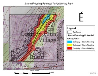
- 1. Storm Flooding Potential for University Park Brian C. Averitt November 8, 2007 Legend Tax Parcel Storm Flooding Potential CATEGORY Category 1 Storm Flooding Category 2 Storm Flooding Category 3 Storm Flooding É 300 0 300150 Meters 1:6,000.040968