SlideShare a Scribd company logo
1 of 9
Download to read offline
Convert AutoCAD .dwg files to .shp files:
Making a CAD .dwg file readable in GIS, georeferencing it to
the existing .shp files and converting it to a .shp file.
Part 1: Opening and Georeferencing a .dwg file in ArcMap
1. Start with ArcMap and a shapefile of the area you are trying to match to
your .dwg drawing.
You will need to know the exact coordinates of two points on this existing
.shp file so you can “stretch” or adjust the CAD drawing to match these two
points.
2. You will likely need the full version of ArcGIS (ArcMap) and not the
educational trial version as you will need to utilize the Georeferencing tool.
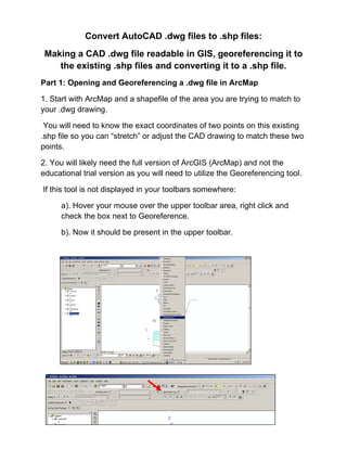
If this tool is not displayed in your toolbars somewhere:
a). Hover your mouse over the upper toolbar area, right click and
check the box next to Georeference.
b). Now it should be present in the upper toolbar.
3. Add the .dwg file just as you would add any other .shp file.
You will get a message box that tells you that you can add the drawing, but
it is not projected. Click OK.
4. Go to the Layer tool (of the Georeferencing toolbar) and select the
polyline, point or polygon option in the drop down menu. (This selection
depends on what you are georeferencing. In this tutorial we are working
with polygons.)
5. In the ArcMap Layers display, select your .dwg file. Make sure your map
is zoomed to about the area where you want to fit your .dwg file.
In the Georeferencing toolbar, select Fit to Display.
This will bring the .dwg immediately over the existing .shp file, though they
will not match up yet…but at least you can see it's in the neighborhood.
Now you are ready to georeference the .dwg file.
6. Click on the icon in the Georeferencing toolbar that has two little x’s, one
green and one red…connected by a small line.
You will use this tool to match two points on the .dwg with two points on the
.shp file.
7. In this tutorial there is a shapefile with two points that correspond with
two corner points of polygons on the .dwg file.
Once you select the tool, your mouse will be a crosshair:
a).Click on the first point to line up on the .dwg layer.
b).Click on the point that matches on the shapefile.
(Zoom in and pan as needed to get more accurate with selecting
these points.)
c). Repeat this with the other points. Ideally, you would do this for two
or more points at opposite corners of the drawing. Less than two can
warp or distort the CAD drawing and reduce the accuracy.
8. Once you have all your points selected with the crosshair tool, select
“Update Display” from the Georeferencing dropdown list.
9. You may want to zoom in on the points you used to align the CAD file
and insure they are lined up. Repeat steps 6-8 until you are satisfied with
the alignment of your .dwg with the rest of your .shp files.
Note: You will notice on the example that
ArcMap imported all the layer types that existed
on the .dwg file. If there are layers you do not
want, click on the box with a plus sign next to the
.dwg listing in the ArcMap Layer display.
Uncheck the CAD layers you do not want. In this
case, the Annotation layer includes the text from
CAD. Uncheck to turn off the text.
Part 2: Convert a .dwg file to a .shp file.
1.Right click on the layer within the .dwg file you want to convert.
Select “Data”. Select “Export Data”.
2. In the “Export Data” window, the default to Export is “All Features”. You
should not have to change any of the other settings except for a place to
save the new file.
Select the folder icon.
Browse to where you want to save the new shapefile.
Name the shapefile. Select Save.
Select OK in the “Export Data” window.
3. A window will open to ask if you would like to add the exported data to
the map as a layer. Select Yes.
Your new shapefile will open onto the map. Now you may remove the .dwg
file from the Layer display.

More Related Content

What's hot

bangun ruang sisi datar dan sisi lengkung
bangun ruang sisi datar dan sisi lengkungbangun ruang sisi datar dan sisi lengkung
bangun ruang sisi datar dan sisi lengkungDavi Conan
 
PPT Persamaan garis singgung lingkaran
PPT Persamaan garis singgung lingkaranPPT Persamaan garis singgung lingkaran
PPT Persamaan garis singgung lingkarantrisno direction
 
8.3.8 modul lingkaran (reno sutriono)
8.3.8 modul lingkaran (reno sutriono)8.3.8 modul lingkaran (reno sutriono)
8.3.8 modul lingkaran (reno sutriono)reno sutriono
 
Sejarah perkembangan matematika
Sejarah perkembangan matematikaSejarah perkembangan matematika
Sejarah perkembangan matematikaAisyah Turidho
 
Kurikulum dan pembelajaran Matematika
Kurikulum dan pembelajaran  Matematika Kurikulum dan pembelajaran  Matematika
Kurikulum dan pembelajaran Matematika devi kumala sari
 
Olahraga
OlahragaOlahraga
Olahragasham
 
Tema 5. kesedaran badan
Tema 5. kesedaran badanTema 5. kesedaran badan
Tema 5. kesedaran badanSafiee Kassim
 
Buku program pismp pendidikan jasmani dengan kepujian
Buku program pismp pendidikan jasmani dengan kepujianBuku program pismp pendidikan jasmani dengan kepujian
Buku program pismp pendidikan jasmani dengan kepujianmond niel
 
Fluida cairan dan gas
Fluida   cairan dan gasFluida   cairan dan gas
Fluida cairan dan gashoshirami
 
Isu etika dan perundangan
Isu etika dan perundanganIsu etika dan perundangan
Isu etika dan perundanganbiedintan
 
PLSV & PtLSV (Perkalian & Pembagian Aljabar) - P4
PLSV & PtLSV (Perkalian & Pembagian Aljabar) - P4PLSV & PtLSV (Perkalian & Pembagian Aljabar) - P4
PLSV & PtLSV (Perkalian & Pembagian Aljabar) - P4Shinta Novianti
 
KEMIRINGAN PADA PERSAMAAN GARIS LURUS (kelas 8).pptx
KEMIRINGAN PADA PERSAMAAN GARIS LURUS (kelas 8).pptxKEMIRINGAN PADA PERSAMAAN GARIS LURUS (kelas 8).pptx
KEMIRINGAN PADA PERSAMAAN GARIS LURUS (kelas 8).pptxAriefiaSardini
 
1 fungsi sistem biologi kawalan motor
1 fungsi sistem biologi kawalan motor1 fungsi sistem biologi kawalan motor
1 fungsi sistem biologi kawalan motorMohamad Ihtifazuddin
 
Modul Khusus Materi Statistika Kelas 8 SMP
Modul Khusus Materi Statistika Kelas 8 SMPModul Khusus Materi Statistika Kelas 8 SMP
Modul Khusus Materi Statistika Kelas 8 SMPIwan Sumantri
 

What's hot (20)

bangun ruang sisi datar dan sisi lengkung
bangun ruang sisi datar dan sisi lengkungbangun ruang sisi datar dan sisi lengkung
bangun ruang sisi datar dan sisi lengkung
 
PPT Persamaan garis singgung lingkaran
PPT Persamaan garis singgung lingkaranPPT Persamaan garis singgung lingkaran
PPT Persamaan garis singgung lingkaran
 
8.3.8 modul lingkaran (reno sutriono)
8.3.8 modul lingkaran (reno sutriono)8.3.8 modul lingkaran (reno sutriono)
8.3.8 modul lingkaran (reno sutriono)
 
Sejarah perkembangan matematika
Sejarah perkembangan matematikaSejarah perkembangan matematika
Sejarah perkembangan matematika
 
Gerak parabola
Gerak parabolaGerak parabola
Gerak parabola
 
Kurikulum dan pembelajaran Matematika
Kurikulum dan pembelajaran  Matematika Kurikulum dan pembelajaran  Matematika
Kurikulum dan pembelajaran Matematika
 
Merejam lembing 2
Merejam lembing 2Merejam lembing 2
Merejam lembing 2
 
Olahraga
OlahragaOlahraga
Olahraga
 
Tema 5. kesedaran badan
Tema 5. kesedaran badanTema 5. kesedaran badan
Tema 5. kesedaran badan
 
Buku program pismp pendidikan jasmani dengan kepujian
Buku program pismp pendidikan jasmani dengan kepujianBuku program pismp pendidikan jasmani dengan kepujian
Buku program pismp pendidikan jasmani dengan kepujian
 
Fluida cairan dan gas
Fluida   cairan dan gasFluida   cairan dan gas
Fluida cairan dan gas
 
Geometri aksioma
Geometri aksiomaGeometri aksioma
Geometri aksioma
 
Isu etika dan perundangan
Isu etika dan perundanganIsu etika dan perundangan
Isu etika dan perundangan
 
PLSV & PtLSV (Perkalian & Pembagian Aljabar) - P4
PLSV & PtLSV (Perkalian & Pembagian Aljabar) - P4PLSV & PtLSV (Perkalian & Pembagian Aljabar) - P4
PLSV & PtLSV (Perkalian & Pembagian Aljabar) - P4
 
Olahraga - Bleep Test
Olahraga - Bleep TestOlahraga - Bleep Test
Olahraga - Bleep Test
 
Rpp spldv
Rpp spldvRpp spldv
Rpp spldv
 
Ppt simetri lipat me
Ppt simetri lipat mePpt simetri lipat me
Ppt simetri lipat me
 
KEMIRINGAN PADA PERSAMAAN GARIS LURUS (kelas 8).pptx
KEMIRINGAN PADA PERSAMAAN GARIS LURUS (kelas 8).pptxKEMIRINGAN PADA PERSAMAAN GARIS LURUS (kelas 8).pptx
KEMIRINGAN PADA PERSAMAAN GARIS LURUS (kelas 8).pptx
 
1 fungsi sistem biologi kawalan motor
1 fungsi sistem biologi kawalan motor1 fungsi sistem biologi kawalan motor
1 fungsi sistem biologi kawalan motor
 
Modul Khusus Materi Statistika Kelas 8 SMP
Modul Khusus Materi Statistika Kelas 8 SMPModul Khusus Materi Statistika Kelas 8 SMP
Modul Khusus Materi Statistika Kelas 8 SMP
 

Viewers also liked

Koreksi geometrik peta (arc gis) registrasi
Koreksi geometrik peta (arc gis) registrasiKoreksi geometrik peta (arc gis) registrasi
Koreksi geometrik peta (arc gis) registrasifikrul islamy
 
Prospectus FPIK Brawijaya university (concept 2012)
Prospectus FPIK Brawijaya university  (concept 2012)Prospectus FPIK Brawijaya university  (concept 2012)
Prospectus FPIK Brawijaya university (concept 2012)fikrul islamy
 
Secrets of supercomputing
Secrets of supercomputingSecrets of supercomputing
Secrets of supercomputingfikrul islamy
 
Akar persamaan2 metnum
Akar persamaan2 metnumAkar persamaan2 metnum
Akar persamaan2 metnumfikrul islamy
 
Bab 3 bangun_datar_dan_bangun_ruang
Bab 3 bangun_datar_dan_bangun_ruangBab 3 bangun_datar_dan_bangun_ruang
Bab 3 bangun_datar_dan_bangun_ruangEka Nuryani
 
KELILING DAN LUAS LINGKARAN (Neni Susanti)
KELILING DAN LUAS LINGKARAN (Neni Susanti)KELILING DAN LUAS LINGKARAN (Neni Susanti)
KELILING DAN LUAS LINGKARAN (Neni Susanti)Neni Susanti
 

Viewers also liked (9)

Koreksi geometrik peta (arc gis) registrasi
Koreksi geometrik peta (arc gis) registrasiKoreksi geometrik peta (arc gis) registrasi
Koreksi geometrik peta (arc gis) registrasi
 
Module net cdf4
Module net cdf4 Module net cdf4
Module net cdf4
 
SIM
SIMSIM
SIM
 
Prospectus FPIK Brawijaya university (concept 2012)
Prospectus FPIK Brawijaya university  (concept 2012)Prospectus FPIK Brawijaya university  (concept 2012)
Prospectus FPIK Brawijaya university (concept 2012)
 
Secrets of supercomputing
Secrets of supercomputingSecrets of supercomputing
Secrets of supercomputing
 
Akar persamaan2 metnum
Akar persamaan2 metnumAkar persamaan2 metnum
Akar persamaan2 metnum
 
Python arch wiki
Python   arch wikiPython   arch wiki
Python arch wiki
 
Bab 3 bangun_datar_dan_bangun_ruang
Bab 3 bangun_datar_dan_bangun_ruangBab 3 bangun_datar_dan_bangun_ruang
Bab 3 bangun_datar_dan_bangun_ruang
 
KELILING DAN LUAS LINGKARAN (Neni Susanti)
KELILING DAN LUAS LINGKARAN (Neni Susanti)KELILING DAN LUAS LINGKARAN (Neni Susanti)
KELILING DAN LUAS LINGKARAN (Neni Susanti)
 

Similar to Convert an auto cad file to a shapefile and georeferencing

Introduction to ArcGIS 10.1
Introduction to ArcGIS 10.1Introduction to ArcGIS 10.1
Introduction to ArcGIS 10.1Claudio Montoni
 
Publishing geoprocessing-services-tutorial
Publishing geoprocessing-services-tutorialPublishing geoprocessing-services-tutorial
Publishing geoprocessing-services-tutorialSebastian Correa Gimenez
 
Soil and Water Assessment Tool Procedure
Soil and Water Assessment Tool ProcedureSoil and Water Assessment Tool Procedure
Soil and Water Assessment Tool ProcedureKEFA FEYE
 
Arc Gis Traininng.pptx
Arc Gis Traininng.pptxArc Gis Traininng.pptx
Arc Gis Traininng.pptxImran khan
 
Cgc Make Your Own Gis
Cgc Make Your Own GisCgc Make Your Own Gis
Cgc Make Your Own GistprattHWDSB
 
RS and GIS TW- 1&2.pdf
RS and GIS TW- 1&2.pdfRS and GIS TW- 1&2.pdf
RS and GIS TW- 1&2.pdfSatishKhadse3
 
Global mapper
Global mapperGlobal mapper
Global mapperupn
 
map design by ArcGIS program
map design by ArcGIS programmap design by ArcGIS program
map design by ArcGIS programAlmoutaz Alsaeed
 
Basic commands of ArcGIS
Basic commands of ArcGISBasic commands of ArcGIS
Basic commands of ArcGISKU Leuven
 
Setting up your DUSP ArcGIS Environment
Setting up your DUSP ArcGIS EnvironmentSetting up your DUSP ArcGIS Environment
Setting up your DUSP ArcGIS EnvironmentDUSPviz
 
Intro to ArcGIS ModelBuilder
Intro to ArcGIS ModelBuilderIntro to ArcGIS ModelBuilder
Intro to ArcGIS ModelBuilderDUSPviz
 
Gis arc map& georeferencing-arcgis
Gis arc map& georeferencing-arcgisGis arc map& georeferencing-arcgis
Gis arc map& georeferencing-arcgisAshok Peddi
 
Cgc Introduction Gis
Cgc Introduction GisCgc Introduction Gis
Cgc Introduction GistprattHWDSB
 
Introduction to-arc map
Introduction to-arc mapIntroduction to-arc map
Introduction to-arc mapAshok Peddi
 
Auto cad 2007-tutorial
Auto cad 2007-tutorialAuto cad 2007-tutorial
Auto cad 2007-tutorialSyed Javeed
 
Nycct GIS_primer tutorial
Nycct  GIS_primer tutorialNycct  GIS_primer tutorial
Nycct GIS_primer tutorialNYCCTfab
 

Similar to Convert an auto cad file to a shapefile and georeferencing (20)

Introduction to ArcGIS 10.1
Introduction to ArcGIS 10.1Introduction to ArcGIS 10.1
Introduction to ArcGIS 10.1
 
Publishing geoprocessing-services-tutorial
Publishing geoprocessing-services-tutorialPublishing geoprocessing-services-tutorial
Publishing geoprocessing-services-tutorial
 
GIS practicals
GIS  practicals GIS  practicals
GIS practicals
 
Soil and Water Assessment Tool Procedure
Soil and Water Assessment Tool ProcedureSoil and Water Assessment Tool Procedure
Soil and Water Assessment Tool Procedure
 
Arc Gis Traininng.pptx
Arc Gis Traininng.pptxArc Gis Traininng.pptx
Arc Gis Traininng.pptx
 
Cgc Make Your Own Gis
Cgc Make Your Own GisCgc Make Your Own Gis
Cgc Make Your Own Gis
 
RS and GIS TW- 1&2.pdf
RS and GIS TW- 1&2.pdfRS and GIS TW- 1&2.pdf
RS and GIS TW- 1&2.pdf
 
Global mapper
Global mapperGlobal mapper
Global mapper
 
map design by ArcGIS program
map design by ArcGIS programmap design by ArcGIS program
map design by ArcGIS program
 
Ex32018.pdf
Ex32018.pdfEx32018.pdf
Ex32018.pdf
 
Get the Sheet out of here! Plan production for jobs due yesterday
Get the Sheet out of here! Plan production for jobs due yesterdayGet the Sheet out of here! Plan production for jobs due yesterday
Get the Sheet out of here! Plan production for jobs due yesterday
 
Basic commands of ArcGIS
Basic commands of ArcGISBasic commands of ArcGIS
Basic commands of ArcGIS
 
Setting up your DUSP ArcGIS Environment
Setting up your DUSP ArcGIS EnvironmentSetting up your DUSP ArcGIS Environment
Setting up your DUSP ArcGIS Environment
 
Intro to ArcGIS ModelBuilder
Intro to ArcGIS ModelBuilderIntro to ArcGIS ModelBuilder
Intro to ArcGIS ModelBuilder
 
Gis arc map& georeferencing-arcgis
Gis arc map& georeferencing-arcgisGis arc map& georeferencing-arcgis
Gis arc map& georeferencing-arcgis
 
Cgc Introduction Gis
Cgc Introduction GisCgc Introduction Gis
Cgc Introduction Gis
 
Introduction to-arc map
Introduction to-arc mapIntroduction to-arc map
Introduction to-arc map
 
High res cartographic modeling lab
High res cartographic modeling labHigh res cartographic modeling lab
High res cartographic modeling lab
 
Auto cad 2007-tutorial
Auto cad 2007-tutorialAuto cad 2007-tutorial
Auto cad 2007-tutorial
 
Nycct GIS_primer tutorial
Nycct  GIS_primer tutorialNycct  GIS_primer tutorial
Nycct GIS_primer tutorial
 

More from fikrul islamy

Kemas & eclogite #GEOLOGI
Kemas & eclogite #GEOLOGI Kemas & eclogite #GEOLOGI
Kemas & eclogite #GEOLOGI fikrul islamy
 
PERMODELAN TSUNAMI UNTUK PENENTUAN ZONA MITIGASI DAN ANALISIS DAMPAK TERHADAP...
PERMODELAN TSUNAMI UNTUK PENENTUAN ZONA MITIGASI DAN ANALISIS DAMPAK TERHADAP...PERMODELAN TSUNAMI UNTUK PENENTUAN ZONA MITIGASI DAN ANALISIS DAMPAK TERHADAP...
PERMODELAN TSUNAMI UNTUK PENENTUAN ZONA MITIGASI DAN ANALISIS DAMPAK TERHADAP...fikrul islamy
 
Lirik & chord lagu mix 1
Lirik & chord lagu mix 1Lirik & chord lagu mix 1
Lirik & chord lagu mix 1fikrul islamy
 
Lirik & chord lagu mix 3
Lirik & chord lagu mix  3Lirik & chord lagu mix  3
Lirik & chord lagu mix 3fikrul islamy
 
Teknologi gis dan analisis spasial di zona pesisir manajemen
Teknologi gis dan analisis spasial di zona pesisir manajemenTeknologi gis dan analisis spasial di zona pesisir manajemen
Teknologi gis dan analisis spasial di zona pesisir manajemenfikrul islamy
 
Pendekatan unt-membangun-sistem
Pendekatan unt-membangun-sistemPendekatan unt-membangun-sistem
Pendekatan unt-membangun-sistemfikrul islamy
 
Koreksi geometrik peta (arc gis) registrasi
Koreksi geometrik peta (arc gis) registrasiKoreksi geometrik peta (arc gis) registrasi
Koreksi geometrik peta (arc gis) registrasifikrul islamy
 
Bangun datar dan bangun datar
Bangun datar dan bangun datarBangun datar dan bangun datar
Bangun datar dan bangun datarfikrul islamy
 
Pengolahan sst satelit modis
Pengolahan sst satelit modisPengolahan sst satelit modis
Pengolahan sst satelit modisfikrul islamy
 
Coastal zone management ruang pesisir
Coastal zone management ruang pesisirCoastal zone management ruang pesisir
Coastal zone management ruang pesisirfikrul islamy
 
Peta dan-penggunaanya
Peta dan-penggunaanyaPeta dan-penggunaanya
Peta dan-penggunaanyafikrul islamy
 
Algoritma dan flowchart
Algoritma dan flowchartAlgoritma dan flowchart
Algoritma dan flowchartfikrul islamy
 
Teknologi gis dan analisis spasial di zona pesisir manajemen
Teknologi gis dan analisis spasial di zona pesisir manajemenTeknologi gis dan analisis spasial di zona pesisir manajemen
Teknologi gis dan analisis spasial di zona pesisir manajemenfikrul islamy
 
Secrets of supercomputing
Secrets of supercomputingSecrets of supercomputing
Secrets of supercomputingfikrul islamy
 

More from fikrul islamy (20)

sedimen transport
sedimen transportsedimen transport
sedimen transport
 
Marine mammals
Marine mammalsMarine mammals
Marine mammals
 
Kemas & eclogite #GEOLOGI
Kemas & eclogite #GEOLOGI Kemas & eclogite #GEOLOGI
Kemas & eclogite #GEOLOGI
 
PERMODELAN TSUNAMI UNTUK PENENTUAN ZONA MITIGASI DAN ANALISIS DAMPAK TERHADAP...
PERMODELAN TSUNAMI UNTUK PENENTUAN ZONA MITIGASI DAN ANALISIS DAMPAK TERHADAP...PERMODELAN TSUNAMI UNTUK PENENTUAN ZONA MITIGASI DAN ANALISIS DAMPAK TERHADAP...
PERMODELAN TSUNAMI UNTUK PENENTUAN ZONA MITIGASI DAN ANALISIS DAMPAK TERHADAP...
 
Lirik & chord lagu mix 1
Lirik & chord lagu mix 1Lirik & chord lagu mix 1
Lirik & chord lagu mix 1
 
Lirik & chord lagu mix 3
Lirik & chord lagu mix  3Lirik & chord lagu mix  3
Lirik & chord lagu mix 3
 
Teknologi gis dan analisis spasial di zona pesisir manajemen
Teknologi gis dan analisis spasial di zona pesisir manajemenTeknologi gis dan analisis spasial di zona pesisir manajemen
Teknologi gis dan analisis spasial di zona pesisir manajemen
 
Quali tas movie
Quali tas movieQuali tas movie
Quali tas movie
 
Pendekatan unt-membangun-sistem
Pendekatan unt-membangun-sistemPendekatan unt-membangun-sistem
Pendekatan unt-membangun-sistem
 
Koreksi geometrik peta (arc gis) registrasi
Koreksi geometrik peta (arc gis) registrasiKoreksi geometrik peta (arc gis) registrasi
Koreksi geometrik peta (arc gis) registrasi
 
Bangun datar dan bangun datar
Bangun datar dan bangun datarBangun datar dan bangun datar
Bangun datar dan bangun datar
 
Pengolahan sst satelit modis
Pengolahan sst satelit modisPengolahan sst satelit modis
Pengolahan sst satelit modis
 
Coastal zone management ruang pesisir
Coastal zone management ruang pesisirCoastal zone management ruang pesisir
Coastal zone management ruang pesisir
 
Peta dan-penggunaanya
Peta dan-penggunaanyaPeta dan-penggunaanya
Peta dan-penggunaanya
 
Peta dan-demografi
Peta dan-demografiPeta dan-demografi
Peta dan-demografi
 
Pergerakan lempeng
Pergerakan lempengPergerakan lempeng
Pergerakan lempeng
 
Algoritma dan flowchart
Algoritma dan flowchartAlgoritma dan flowchart
Algoritma dan flowchart
 
Handout kartografi
Handout kartografiHandout kartografi
Handout kartografi
 
Teknologi gis dan analisis spasial di zona pesisir manajemen
Teknologi gis dan analisis spasial di zona pesisir manajemenTeknologi gis dan analisis spasial di zona pesisir manajemen
Teknologi gis dan analisis spasial di zona pesisir manajemen
 
Secrets of supercomputing
Secrets of supercomputingSecrets of supercomputing
Secrets of supercomputing
 

Recently uploaded

Judging the Relevance and worth of ideas part 2.pptx
Judging the Relevance  and worth of ideas part 2.pptxJudging the Relevance  and worth of ideas part 2.pptx
Judging the Relevance and worth of ideas part 2.pptxSherlyMaeNeri
 
Incoming and Outgoing Shipments in 3 STEPS Using Odoo 17
Incoming and Outgoing Shipments in 3 STEPS Using Odoo 17Incoming and Outgoing Shipments in 3 STEPS Using Odoo 17
Incoming and Outgoing Shipments in 3 STEPS Using Odoo 17Celine George
 
Proudly South Africa powerpoint Thorisha.pptx
Proudly South Africa powerpoint Thorisha.pptxProudly South Africa powerpoint Thorisha.pptx
Proudly South Africa powerpoint Thorisha.pptxthorishapillay1
 
What is Model Inheritance in Odoo 17 ERP
What is Model Inheritance in Odoo 17 ERPWhat is Model Inheritance in Odoo 17 ERP
What is Model Inheritance in Odoo 17 ERPCeline George
 
Q4 English4 Week3 PPT Melcnmg-based.pptx
Q4 English4 Week3 PPT Melcnmg-based.pptxQ4 English4 Week3 PPT Melcnmg-based.pptx
Q4 English4 Week3 PPT Melcnmg-based.pptxnelietumpap1
 
Keynote by Prof. Wurzer at Nordex about IP-design
Keynote by Prof. Wurzer at Nordex about IP-designKeynote by Prof. Wurzer at Nordex about IP-design
Keynote by Prof. Wurzer at Nordex about IP-designMIPLM
 
Science 7 Quarter 4 Module 2: Natural Resources.pptx
Science 7 Quarter 4 Module 2: Natural Resources.pptxScience 7 Quarter 4 Module 2: Natural Resources.pptx
Science 7 Quarter 4 Module 2: Natural Resources.pptxMaryGraceBautista27
 
How to Add Barcode on PDF Report in Odoo 17
How to Add Barcode on PDF Report in Odoo 17How to Add Barcode on PDF Report in Odoo 17
How to Add Barcode on PDF Report in Odoo 17Celine George
 
Earth Day Presentation wow hello nice great
Earth Day Presentation wow hello nice greatEarth Day Presentation wow hello nice great
Earth Day Presentation wow hello nice greatYousafMalik24
 
ACC 2024 Chronicles. Cardiology. Exam.pdf
ACC 2024 Chronicles. Cardiology. Exam.pdfACC 2024 Chronicles. Cardiology. Exam.pdf
ACC 2024 Chronicles. Cardiology. Exam.pdfSpandanaRallapalli
 
Procuring digital preservation CAN be quick and painless with our new dynamic...
Procuring digital preservation CAN be quick and painless with our new dynamic...Procuring digital preservation CAN be quick and painless with our new dynamic...
Procuring digital preservation CAN be quick and painless with our new dynamic...Jisc
 
ENGLISH6-Q4-W3.pptxqurter our high choom
ENGLISH6-Q4-W3.pptxqurter our high choomENGLISH6-Q4-W3.pptxqurter our high choom
ENGLISH6-Q4-W3.pptxqurter our high choomnelietumpap1
 
USPS® Forced Meter Migration - How to Know if Your Postage Meter Will Soon be...
USPS® Forced Meter Migration - How to Know if Your Postage Meter Will Soon be...USPS® Forced Meter Migration - How to Know if Your Postage Meter Will Soon be...
USPS® Forced Meter Migration - How to Know if Your Postage Meter Will Soon be...Postal Advocate Inc.
 
call girls in Kamla Market (DELHI) 🔝 >༒9953330565🔝 genuine Escort Service 🔝✔️✔️
call girls in Kamla Market (DELHI) 🔝 >༒9953330565🔝 genuine Escort Service 🔝✔️✔️call girls in Kamla Market (DELHI) 🔝 >༒9953330565🔝 genuine Escort Service 🔝✔️✔️
call girls in Kamla Market (DELHI) 🔝 >༒9953330565🔝 genuine Escort Service 🔝✔️✔️9953056974 Low Rate Call Girls In Saket, Delhi NCR
 
ANG SEKTOR NG agrikultura.pptx QUARTER 4
ANG SEKTOR NG agrikultura.pptx QUARTER 4ANG SEKTOR NG agrikultura.pptx QUARTER 4
ANG SEKTOR NG agrikultura.pptx QUARTER 4MiaBumagat1
 
Visit to a blind student's school🧑‍🦯🧑‍🦯(community medicine)
Visit to a blind student's school🧑‍🦯🧑‍🦯(community medicine)Visit to a blind student's school🧑‍🦯🧑‍🦯(community medicine)
Visit to a blind student's school🧑‍🦯🧑‍🦯(community medicine)lakshayb543
 

Recently uploaded (20)

Judging the Relevance and worth of ideas part 2.pptx
Judging the Relevance  and worth of ideas part 2.pptxJudging the Relevance  and worth of ideas part 2.pptx
Judging the Relevance and worth of ideas part 2.pptx
 
Incoming and Outgoing Shipments in 3 STEPS Using Odoo 17
Incoming and Outgoing Shipments in 3 STEPS Using Odoo 17Incoming and Outgoing Shipments in 3 STEPS Using Odoo 17
Incoming and Outgoing Shipments in 3 STEPS Using Odoo 17
 
LEFT_ON_C'N_ PRELIMS_EL_DORADO_2024.pptx
LEFT_ON_C'N_ PRELIMS_EL_DORADO_2024.pptxLEFT_ON_C'N_ PRELIMS_EL_DORADO_2024.pptx
LEFT_ON_C'N_ PRELIMS_EL_DORADO_2024.pptx
 
Proudly South Africa powerpoint Thorisha.pptx
Proudly South Africa powerpoint Thorisha.pptxProudly South Africa powerpoint Thorisha.pptx
Proudly South Africa powerpoint Thorisha.pptx
 
What is Model Inheritance in Odoo 17 ERP
What is Model Inheritance in Odoo 17 ERPWhat is Model Inheritance in Odoo 17 ERP
What is Model Inheritance in Odoo 17 ERP
 
Q4 English4 Week3 PPT Melcnmg-based.pptx
Q4 English4 Week3 PPT Melcnmg-based.pptxQ4 English4 Week3 PPT Melcnmg-based.pptx
Q4 English4 Week3 PPT Melcnmg-based.pptx
 
Keynote by Prof. Wurzer at Nordex about IP-design
Keynote by Prof. Wurzer at Nordex about IP-designKeynote by Prof. Wurzer at Nordex about IP-design
Keynote by Prof. Wurzer at Nordex about IP-design
 
Science 7 Quarter 4 Module 2: Natural Resources.pptx
Science 7 Quarter 4 Module 2: Natural Resources.pptxScience 7 Quarter 4 Module 2: Natural Resources.pptx
Science 7 Quarter 4 Module 2: Natural Resources.pptx
 
TataKelola dan KamSiber Kecerdasan Buatan v022.pdf
TataKelola dan KamSiber Kecerdasan Buatan v022.pdfTataKelola dan KamSiber Kecerdasan Buatan v022.pdf
TataKelola dan KamSiber Kecerdasan Buatan v022.pdf
 
YOUVE GOT EMAIL_FINALS_EL_DORADO_2024.pptx
YOUVE GOT EMAIL_FINALS_EL_DORADO_2024.pptxYOUVE GOT EMAIL_FINALS_EL_DORADO_2024.pptx
YOUVE GOT EMAIL_FINALS_EL_DORADO_2024.pptx
 
How to Add Barcode on PDF Report in Odoo 17
How to Add Barcode on PDF Report in Odoo 17How to Add Barcode on PDF Report in Odoo 17
How to Add Barcode on PDF Report in Odoo 17
 
Earth Day Presentation wow hello nice great
Earth Day Presentation wow hello nice greatEarth Day Presentation wow hello nice great
Earth Day Presentation wow hello nice great
 
ACC 2024 Chronicles. Cardiology. Exam.pdf
ACC 2024 Chronicles. Cardiology. Exam.pdfACC 2024 Chronicles. Cardiology. Exam.pdf
ACC 2024 Chronicles. Cardiology. Exam.pdf
 
Procuring digital preservation CAN be quick and painless with our new dynamic...
Procuring digital preservation CAN be quick and painless with our new dynamic...Procuring digital preservation CAN be quick and painless with our new dynamic...
Procuring digital preservation CAN be quick and painless with our new dynamic...
 
ENGLISH6-Q4-W3.pptxqurter our high choom
ENGLISH6-Q4-W3.pptxqurter our high choomENGLISH6-Q4-W3.pptxqurter our high choom
ENGLISH6-Q4-W3.pptxqurter our high choom
 
USPS® Forced Meter Migration - How to Know if Your Postage Meter Will Soon be...
USPS® Forced Meter Migration - How to Know if Your Postage Meter Will Soon be...USPS® Forced Meter Migration - How to Know if Your Postage Meter Will Soon be...
USPS® Forced Meter Migration - How to Know if Your Postage Meter Will Soon be...
 
call girls in Kamla Market (DELHI) 🔝 >༒9953330565🔝 genuine Escort Service 🔝✔️✔️
call girls in Kamla Market (DELHI) 🔝 >༒9953330565🔝 genuine Escort Service 🔝✔️✔️call girls in Kamla Market (DELHI) 🔝 >༒9953330565🔝 genuine Escort Service 🔝✔️✔️
call girls in Kamla Market (DELHI) 🔝 >༒9953330565🔝 genuine Escort Service 🔝✔️✔️
 
ANG SEKTOR NG agrikultura.pptx QUARTER 4
ANG SEKTOR NG agrikultura.pptx QUARTER 4ANG SEKTOR NG agrikultura.pptx QUARTER 4
ANG SEKTOR NG agrikultura.pptx QUARTER 4
 
OS-operating systems- ch04 (Threads) ...
OS-operating systems- ch04 (Threads) ...OS-operating systems- ch04 (Threads) ...
OS-operating systems- ch04 (Threads) ...
 
Visit to a blind student's school🧑‍🦯🧑‍🦯(community medicine)
Visit to a blind student's school🧑‍🦯🧑‍🦯(community medicine)Visit to a blind student's school🧑‍🦯🧑‍🦯(community medicine)
Visit to a blind student's school🧑‍🦯🧑‍🦯(community medicine)
 

Convert an auto cad file to a shapefile and georeferencing

  • 1. Convert AutoCAD .dwg files to .shp files: Making a CAD .dwg file readable in GIS, georeferencing it to the existing .shp files and converting it to a .shp file. Part 1: Opening and Georeferencing a .dwg file in ArcMap 1. Start with ArcMap and a shapefile of the area you are trying to match to your .dwg drawing. You will need to know the exact coordinates of two points on this existing .shp file so you can “stretch” or adjust the CAD drawing to match these two points. 2. You will likely need the full version of ArcGIS (ArcMap) and not the educational trial version as you will need to utilize the Georeferencing tool. If this tool is not displayed in your toolbars somewhere: a). Hover your mouse over the upper toolbar area, right click and check the box next to Georeference. b). Now it should be present in the upper toolbar.
  • 2. 3. Add the .dwg file just as you would add any other .shp file. You will get a message box that tells you that you can add the drawing, but it is not projected. Click OK. 4. Go to the Layer tool (of the Georeferencing toolbar) and select the polyline, point or polygon option in the drop down menu. (This selection depends on what you are georeferencing. In this tutorial we are working with polygons.)
  • 3. 5. In the ArcMap Layers display, select your .dwg file. Make sure your map is zoomed to about the area where you want to fit your .dwg file. In the Georeferencing toolbar, select Fit to Display. This will bring the .dwg immediately over the existing .shp file, though they will not match up yet…but at least you can see it's in the neighborhood. Now you are ready to georeference the .dwg file.
  • 4. 6. Click on the icon in the Georeferencing toolbar that has two little x’s, one green and one red…connected by a small line. You will use this tool to match two points on the .dwg with two points on the .shp file. 7. In this tutorial there is a shapefile with two points that correspond with two corner points of polygons on the .dwg file. Once you select the tool, your mouse will be a crosshair: a).Click on the first point to line up on the .dwg layer. b).Click on the point that matches on the shapefile. (Zoom in and pan as needed to get more accurate with selecting these points.)
  • 5. c). Repeat this with the other points. Ideally, you would do this for two or more points at opposite corners of the drawing. Less than two can warp or distort the CAD drawing and reduce the accuracy. 8. Once you have all your points selected with the crosshair tool, select “Update Display” from the Georeferencing dropdown list.
  • 6. 9. You may want to zoom in on the points you used to align the CAD file and insure they are lined up. Repeat steps 6-8 until you are satisfied with the alignment of your .dwg with the rest of your .shp files. Note: You will notice on the example that ArcMap imported all the layer types that existed on the .dwg file. If there are layers you do not want, click on the box with a plus sign next to the .dwg listing in the ArcMap Layer display. Uncheck the CAD layers you do not want. In this case, the Annotation layer includes the text from CAD. Uncheck to turn off the text.
  • 7. Part 2: Convert a .dwg file to a .shp file. 1.Right click on the layer within the .dwg file you want to convert. Select “Data”. Select “Export Data”. 2. In the “Export Data” window, the default to Export is “All Features”. You should not have to change any of the other settings except for a place to save the new file. Select the folder icon.
  • 8. Browse to where you want to save the new shapefile. Name the shapefile. Select Save. Select OK in the “Export Data” window. 3. A window will open to ask if you would like to add the exported data to the map as a layer. Select Yes.
  • 9. Your new shapefile will open onto the map. Now you may remove the .dwg file from the Layer display.