Repurposing LNG terminals for Hydrogen Ammonia: Feasibility and Cost Saving
River Tees From Source To Mouth
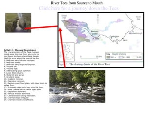
1. River Tees from Source to Mouth Click here for a journey down the Tees Activity 1: Changes Downstream The characteristics of the Tees changes as you move along the river from source to mouth. Add on text boxes to show where these feeeatures are likely to occur along the map of the River Tees. 1. Bed-load very fine and rounded. 2. Bed-load mixed. 3. Bed-load very large and angular. 4. Volume low. 5. Volume high. 6. Interlocking spurs common. 7. Large tidal estuary. 8. Waterfall and gorge. 9. Gradient steep. 10. Gradient minimal. 11. Meanders common. 12. Medium-sized flood plain, with clear limits to valley floor. 13. V-shaped valley with very little flat floor. 14. River channel set in a wide open plain. 15. Deposition dominant. 16. Vertical erosion dominant. 17. Lateral erosion along meanders. 18. Channel shape irregular. 19. Channel smooth and efficient.
2. Websites to Help Photos of the Tees - you will need to type the word Tees at the top in the search box
3. Upper valley characteristics “ V”shape valley , vertical erosion dominant Interlocking spurs Slumping and landslides - very active hillslopes Terracettes formed by soil creep Narrow, shallow channel, low velocity and discharge Large bedload derived from upstream and from valley sides An Example of how your work should look
4. Upper Section of the River Tees High Force formation on the River Tees Describe how high force waterfall is created using your Geo Active worksheet. Use this picure and annotate it with an explanation. (8 marks) This web link may also help you Upper section of the River Tees
5. Rapids / Potholes in the Upper Tees Valley Formation of Rapids in the upper Tees section Describe how rapids and potholes are created using your Geo Active worksheet. Use this picture and annotate it with an explanation. (8 marks) This web link may also help you
6. Middle course, R. Tees Annotate this picture with how the are changes. Use your Geo Active to help you with this. ( 6 marks) Website which may help you
7. Meanders High Force formation on the River Tees Describe how meanders are created using your Geo Active worksheet. Use this picture and annotate it with an explanation. (8 marks) This web link may also help you
8. Ox Bow Lakes near Yarm OX BOW LAKE FORMATION Annotate this picture to explain how Ox Bow lakes are created on the River Tees. Use your Geo Active to help you with this. ( 8 marks)
9. The Mouth of the River Tees Research the features that form at the mouth of the River Tees and explain their formation. Use the Geo Active to help you ( 6 marks)