SlideShare una empresa de Scribd logo
1 de 12
Load the data in ArcMap
Open ArcMap. Click on the Add Data button to add
the census dbf file and the Canada Digital Boundary
file.

                                  The ‘Add Data’ icon…
Both files
should
appear in the
table of
contents
Join the two files
• To join the two files, a
  common field containing
  the same values must be
  identified.

• To identify a common, open
  the attribute table for both
  files by right clicking on
  each file and selecting Open
  Attribute Table.
• You will notice that
  CTUID from the
  boundary file is
  common to COL1 in
  the census table. We
  will use these two
  fields highlighted
  below for our join.

• Close the Attribute
  Tables.
• To join the census data
  to the boundary
  file, right click on the
  boundary file and
  select “Join and
  Relates.”

• Select “Join.”

Note: Do not join starting
with the dbf file to the
boundary file.
In this Join window, choose
the fields that the join will be
based on.

• In this example, we use
  CTUID, and are basing this
  join on COL1 from the
  census table.

• Select the radio bottom to
  “keep only matching
  records”

• Click OK.
Open the Attribute
Table to see if the
join worked.
If the join was
successful,
remove the
.dbf file
To visualize the
census data,
right-click on the
layer, and select
Properties
The layer
properties-
window will
open

Click on
Symbology
Under
Quantities on
the left, select
Graduated
Colors.

You can now
visualize the
census data
using the color
ramp

In this example,
we chose to
visualize col4
Loading joining census_data_arcmap

Más contenido relacionado

La actualidad más candente

6. Shapefiles in gis
6. Shapefiles in gis6. Shapefiles in gis
6. Shapefiles in gisKU Leuven
 
QGIS Module 4
QGIS Module 4QGIS Module 4
QGIS Module 4CAPSUCSF
 
Using Spectrum on Demand from MapInfo Pro
Using Spectrum on Demand from MapInfo ProUsing Spectrum on Demand from MapInfo Pro
Using Spectrum on Demand from MapInfo ProPeter Horsbøll Møller
 
MIT Big Data Explorers - presentation by Daniel Burseth
MIT Big Data Explorers - presentation by Daniel BursethMIT Big Data Explorers - presentation by Daniel Burseth
MIT Big Data Explorers - presentation by Daniel BursethDon Dark
 
Tableau Course syllabus
Tableau Course syllabusTableau Course syllabus
Tableau Course syllabusGpsinfotech
 
Getting the most from the Cambridgeshire Atlas | Fuel Poverty
Getting the most from the Cambridgeshire Atlas | Fuel PovertyGetting the most from the Cambridgeshire Atlas | Fuel Poverty
Getting the most from the Cambridgeshire Atlas | Fuel PovertyCambridgeshireInsight
 
Converting gis contours_to_cad
Converting gis contours_to_cadConverting gis contours_to_cad
Converting gis contours_to_cadbonge02
 

La actualidad más candente (13)

02+ +step+by+step+qgis
02+ +step+by+step+qgis02+ +step+by+step+qgis
02+ +step+by+step+qgis
 
QGIS Tutorial 2
QGIS Tutorial 2QGIS Tutorial 2
QGIS Tutorial 2
 
QGIS Tutorial 1
QGIS Tutorial 1QGIS Tutorial 1
QGIS Tutorial 1
 
6. Shapefiles in gis
6. Shapefiles in gis6. Shapefiles in gis
6. Shapefiles in gis
 
QGIS Module 4
QGIS Module 4QGIS Module 4
QGIS Module 4
 
QGIS training
QGIS trainingQGIS training
QGIS training
 
Using Spectrum on Demand from MapInfo Pro
Using Spectrum on Demand from MapInfo ProUsing Spectrum on Demand from MapInfo Pro
Using Spectrum on Demand from MapInfo Pro
 
MIT Big Data Explorers - presentation by Daniel Burseth
MIT Big Data Explorers - presentation by Daniel BursethMIT Big Data Explorers - presentation by Daniel Burseth
MIT Big Data Explorers - presentation by Daniel Burseth
 
Tableau Course syllabus
Tableau Course syllabusTableau Course syllabus
Tableau Course syllabus
 
Getting the most from the Cambridgeshire Atlas | Fuel Poverty
Getting the most from the Cambridgeshire Atlas | Fuel PovertyGetting the most from the Cambridgeshire Atlas | Fuel Poverty
Getting the most from the Cambridgeshire Atlas | Fuel Poverty
 
Arcgis doc
Arcgis doc Arcgis doc
Arcgis doc
 
Hadoop Mapreduce joins
Hadoop Mapreduce joinsHadoop Mapreduce joins
Hadoop Mapreduce joins
 
Converting gis contours_to_cad
Converting gis contours_to_cadConverting gis contours_to_cad
Converting gis contours_to_cad
 

Similar a Loading joining census_data_arcmap

Tutorial - how to create a wheel view
Tutorial - how to create a wheel viewTutorial - how to create a wheel view
Tutorial - how to create a wheel viewMichael Warner
 
Overview of the DSD editor in the new CountrySTAT platform
Overview of the DSD editor in the new CountrySTAT platformOverview of the DSD editor in the new CountrySTAT platform
Overview of the DSD editor in the new CountrySTAT platformFAO
 
" Overview of the DSD and DATA editor in the new CountrySTAT platform "
" Overview of the DSD and DATA editor  in the new CountrySTAT platform  "" Overview of the DSD and DATA editor  in the new CountrySTAT platform  "
" Overview of the DSD and DATA editor in the new CountrySTAT platform "FAO
 
Technology Troubleshooting
Technology TroubleshootingTechnology Troubleshooting
Technology TroubleshootingDonia Teagle
 
monitoring_loads_duration_loadcurve_tutorial.ppt
monitoring_loads_duration_loadcurve_tutorial.pptmonitoring_loads_duration_loadcurve_tutorial.ppt
monitoring_loads_duration_loadcurve_tutorial.pptssuserf71928
 
How to geocode using AbbyisQueen
How to geocode using AbbyisQueenHow to geocode using AbbyisQueen
How to geocode using AbbyisQueenWansoo Im
 
Getting started with Tableau
Getting started with TableauGetting started with Tableau
Getting started with TableauParth Acharya
 
Convert an auto cad file to a shapefile and georeferencing
Convert an auto cad file to a shapefile and georeferencingConvert an auto cad file to a shapefile and georeferencing
Convert an auto cad file to a shapefile and georeferencingfikrul islamy
 
Geohosting english manual
Geohosting english manualGeohosting english manual
Geohosting english manualSDIEDU
 
CREATING A DATASET FROM EXCEL IN POWER BI REPORT BUILDER
CREATING A DATASET FROM EXCEL IN POWER BI REPORT BUILDERCREATING A DATASET FROM EXCEL IN POWER BI REPORT BUILDER
CREATING A DATASET FROM EXCEL IN POWER BI REPORT BUILDERSagarDuttPhuloria
 
Hes troubleshooting
Hes troubleshootingHes troubleshooting
Hes troubleshootingHES
 
Bm access2010-l1-c1 idm
Bm access2010-l1-c1 idmBm access2010-l1-c1 idm
Bm access2010-l1-c1 idmMomsterc1
 
Cgc Make Your Own Gis
Cgc Make Your Own GisCgc Make Your Own Gis
Cgc Make Your Own GistprattHWDSB
 

Similar a Loading joining census_data_arcmap (15)

Tutorial - how to create a wheel view
Tutorial - how to create a wheel viewTutorial - how to create a wheel view
Tutorial - how to create a wheel view
 
Overview of the DSD editor in the new CountrySTAT platform
Overview of the DSD editor in the new CountrySTAT platformOverview of the DSD editor in the new CountrySTAT platform
Overview of the DSD editor in the new CountrySTAT platform
 
Exercise 6
Exercise 6Exercise 6
Exercise 6
 
" Overview of the DSD and DATA editor in the new CountrySTAT platform "
" Overview of the DSD and DATA editor  in the new CountrySTAT platform  "" Overview of the DSD and DATA editor  in the new CountrySTAT platform  "
" Overview of the DSD and DATA editor in the new CountrySTAT platform "
 
Technology Troubleshooting
Technology TroubleshootingTechnology Troubleshooting
Technology Troubleshooting
 
monitoring_loads_duration_loadcurve_tutorial.ppt
monitoring_loads_duration_loadcurve_tutorial.pptmonitoring_loads_duration_loadcurve_tutorial.ppt
monitoring_loads_duration_loadcurve_tutorial.ppt
 
How to geocode using AbbyisQueen
How to geocode using AbbyisQueenHow to geocode using AbbyisQueen
How to geocode using AbbyisQueen
 
Getting started with Tableau
Getting started with TableauGetting started with Tableau
Getting started with Tableau
 
Convert an auto cad file to a shapefile and georeferencing
Convert an auto cad file to a shapefile and georeferencingConvert an auto cad file to a shapefile and georeferencing
Convert an auto cad file to a shapefile and georeferencing
 
Geohosting english manual
Geohosting english manualGeohosting english manual
Geohosting english manual
 
Card scan manual
Card scan manualCard scan manual
Card scan manual
 
CREATING A DATASET FROM EXCEL IN POWER BI REPORT BUILDER
CREATING A DATASET FROM EXCEL IN POWER BI REPORT BUILDERCREATING A DATASET FROM EXCEL IN POWER BI REPORT BUILDER
CREATING A DATASET FROM EXCEL IN POWER BI REPORT BUILDER
 
Hes troubleshooting
Hes troubleshootingHes troubleshooting
Hes troubleshooting
 
Bm access2010-l1-c1 idm
Bm access2010-l1-c1 idmBm access2010-l1-c1 idm
Bm access2010-l1-c1 idm
 
Cgc Make Your Own Gis
Cgc Make Your Own GisCgc Make Your Own Gis
Cgc Make Your Own Gis
 

Loading joining census_data_arcmap

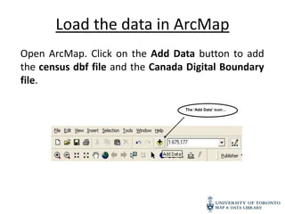
  • 1. Load the data in ArcMap Open ArcMap. Click on the Add Data button to add the census dbf file and the Canada Digital Boundary file. The ‘Add Data’ icon…
  • 2. Both files should appear in the table of contents
  • 3. Join the two files • To join the two files, a common field containing the same values must be identified. • To identify a common, open the attribute table for both files by right clicking on each file and selecting Open Attribute Table.
  • 4. • You will notice that CTUID from the boundary file is common to COL1 in the census table. We will use these two fields highlighted below for our join. • Close the Attribute Tables.
  • 5. • To join the census data to the boundary file, right click on the boundary file and select “Join and Relates.” • Select “Join.” Note: Do not join starting with the dbf file to the boundary file.
  • 6. In this Join window, choose the fields that the join will be based on. • In this example, we use CTUID, and are basing this join on COL1 from the census table. • Select the radio bottom to “keep only matching records” • Click OK.
  • 7. Open the Attribute Table to see if the join worked.
  • 8. If the join was successful, remove the .dbf file
  • 9. To visualize the census data, right-click on the layer, and select Properties
  • 11. Under Quantities on the left, select Graduated Colors. You can now visualize the census data using the color ramp In this example, we chose to visualize col4