Presentation poinproc wherecamp
•
1 recomendación•342 vistas

poinproc marker clustering cartographic generalization

Recomendados
Más contenido relacionado
La actualidad más candente
La actualidad más candente (20)
Destacado
Similar a Presentation poinproc wherecamp
Similar a Presentation poinproc wherecamp (20)
Último
Último (20)
Presentation poinproc wherecamp
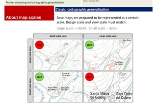
- 1. Marker clustering and cartographic generalization Berlin, november 2014. About map scales Classic cartographic generalization Base maps are prepared to be represented at a certain scale. Design scale and view scale must match. Large scale: + detail. Small scale: - detail. SSmmaallll ssccaallee vviieeww LLaarrggee ssccaallee vviieeww Large scale base Bad Well Small scale base Well Bad
- 2. Cartographic sources are drawn at a detailed scales. Then they’re submitted to cartographic generalization to obtain cartography at smaller scales. 3D feature digitizing environment for ArcGIS from geo-referenced aerial or space-borne imagery (Purview). Marker clustering and cartographic generalization Berlin, november 2014. About map scales Classic cartographic generalization Base maps are outlined from aerial photography.
- 3. Marker clustering and cartographic generalization Berlin, november 2014. Base maps for web map viewers are prepared following the same approach as classic (paper) map series. About map scales Classic cartographic generalization Maps to be shown at different scales are drawn differently Google Maps street map: its design is road map like.
- 4. Tools to obtain base maps at less detailed scales: cartographic generalization tools. Sometimes the application will require some amount of work. Classification. Simplification. Marker clustering and cartographic generalization Berlin, november 2014. About map scales Classic cartographic generalization Aggregation. Collapsing. Selection.
- 5. Marker clustering and cartographic generalization Berlin, november 2014. But that’s not the case with Douglas-Peuker classic algorithm to remove vertices automatically for line simplification, which is fully automatic. About map scales Classic cartographic generalization Douglas-Peuker method applied to polyline with a single line. It is internally implemented in all internet map viewers.
- 6. Marker clustering and cartographic generalization Berlin, november 2014. About internet mapping Marker clustering A set of markers is embedded into a vector layer. It can be displayed as a map overlay for internet viewers. The viewer handles scale changes in a way that we’re grown used to. Some vector layer shown at two different zoom levels We’re relying somewhat in the Maps API’s functionality and somewhat in the web designer’s criteria to have a map customized.
- 7. Marker clustering and cartographic generalization Berlin, november 2014. This was Google Maps API’s incorporated marker clustering procedure. About internet mapping Marker clustering Pushpin markers and cluster markers behave differently under a click event http://www.mapadacachaca.com.br/guia/
- 8. Marker clustering and cartographic generalization Berlin, november 2014. Thematic maps are an elegant alternative approach. It is being used a lot with cartographic data base servers (Google’s Fusion Tables, etc.) About internet mapping Marker clustering Thematic maps require polygon boundary layers and a data summary for each administrative entity. http://www.cartovista.com/
- 9. Marker clustering and cartographic generalization Berlin, november 2014. Another approach to overlay geometries to customize maps is to convert zoom dependant vector overlays into tile layers for web map servers. About internet mapping Marker clustering Rasterizing vectors into tiles overcomes (maps APIs) restricitions to map different layers at different zoom levels. http://www.skimap.org/
- 10. Marker clustering and cartographic generalization Berlin, november 2014. PoinProc’s marker clustering service. It is a cartographic generalization-like approach to swap sets of markers for another zoom dependant geometries. About internet mapping Marker clustering For low zoom levels, results are thematic map alike. Provides flexibility in click event handling.
- 11. Marker clustering and cartographic generalization Berlin, november 2014. About PoinProc Search by map 1 Use map controls 2 Select a place from a list 3 Preview location info 4 Select location and navigate
- 12. Marker clustering and cartographic generalization Berlin, november 2014. PoinProc services About PoinProc Additional services other than marker clustering. Lines from points Paths (lines) clustering Orthodromics generalization
- 13. Marker clustering and cartographic generalization Berlin, november 2014. How to use PoinProc: web You can use the internet service by filling the convenient web form. A data table is required in csv, tab, text format. About PoinProc Latitude and longitude are required. It is desirable to give a name to each marker, as well as geographical entities names to summarize and separate.
- 14. Marker clustering and cartographic generalization Berlin, november 2014. How to use PoinProc: desktop The desktop application is under development. About PoinProc Campos latitud, longitud
- 15. Marker clustering and cartographic generalization Berlin, november 2014. Javascript API Scripts for Web maps APIs: easily loading different geometries for each zoom level. var mapViewer = new ZoomDepViewer (mapdivID, MapClick, LoadIcons, getColour); function MapClick(descrip) { var expla = document.getElementById('expla'); var descripItems = descripTxt.split('.'); var descripHtml = descripItems.join('<br/>'); expla.innerHTML = descripHtml; } var LoadIcons = function(viewer) { var iconfolder = "www.poinproc.com/Schemas/"; var icons; icons[0] = { icon: iconfolder+'point0.png',height:15,width:15 }; icons[1] = { icon: iconfolder+'point1.png',height:22,width:22 }; icons[2] = { icon: iconfolder+'point2.png',height:32,width:32 }; return icons: } function getColour(code) { var fillColor = ["#963296", "#C86432", "#329696", "#48C848", "#6432C8"]; var index = code % 5; return fillColor[index]; } mapViewer.showXMLData(xmlData, viewer, useIDs); // viewer :'gmapsv3', 'bing', 'ol' About PoinProc