
Recomendados
Recomendados
Más contenido relacionado
Destacado
Destacado (20)
Triangulation slides
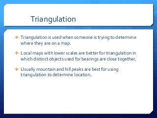
- 1. Triangulation Triangulation is used when someone is trying to determine where they are on a map. Local maps with lower scales are better for triangulation in which distinct objects used for bearings are close together. Usually mountain and hill peaks are best for using triangulation to determine location.
- 2. When picking distinct objects one can see for triangulation, you must make sure these objects are clear on the map as well Also when bearings are taken they must be at least 60 degrees apart Lay the compass on the map and draw a line for each bearing When drawing the line, make sure the edge of the compass is close to the landmark Also make sure the orienting arrows on the compass are parallel to the maps north south meridian lines
- 3. See where the lines intersect This is where your location is For a more accurate triangulation you can see three distinct features, which are also on a map, you can get the bearings from three features or objects Then transfer the three lines too a map and find where they intersect
- 5. In the previous photo, three bearings are taken using three different high elevations, seen as peaks on the map by contour lines, than the lines are used to get the location. Note that this triangulation would not be possible, if one of these peaks are not visible, as well if there are multiple peaks are around on the map, you have to be careful when transferring the bearing from real life to the map.