The 2011 Missouri River Flood Coordinating Response and Recovery
•
2 recomendaciones•450 vistas

ITS Heartland 2012 Annual Meeting Kansas City, MO Please visit our Vimeo site to access voice narrated presentations: https://vimeo.com/matc/review/42207928/c28eb69b0e Presented by John Haas, Statewide Emergency Operations, Iowa Department of Transportation

Recomendados
Recomendados
Más contenido relacionado
Destacado
Destacado (15)
Más de Mid-America Transportation Center
Más de Mid-America Transportation Center (20)
Último
Último (20)
The 2011 Missouri River Flood Coordinating Response and Recovery
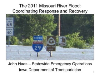
- 1. The 2011 Missouri River Flood: Coordinating Response and Recovery John Haas – Statewide Emergency Operations Iowa Department of Transportation 1
- 2. Iowa Department 2011 Missouri River Flood of Transportation The Missouri River Basin North Dakota Montana Wyoming South Dakota Iowa Nebraska Colorado Missouri 2
- 3. Iowa Department 2011 Missouri River Flood of Transportation Impact upon Iowa’s Primary Roads • I-29, I-680 and other primary routes impacted. – Approximately 60 miles of roads were closed – I-29 closed in two segments covering almost 50 miles • 12 mitigation sites – 7 closures – 5 open sites with mitigation measures in place – 3 of 12 Iowa river crossings closed June 9 – November 3 • Emergency projects to keep sections of I-29 and US 30 open. 4
- 4. 5
- 5. I-29 / I-680 north of Omaha-Council Bluffs I-29 / I-680 Interchange looking west to Omaha. 6
- 6. I-29 / I-680 north of Omaha-Council Bluffs I-29 / I-680 Interchange looking southwest to Omaha. 7
- 7. I-29 north of Omaha-Council Bluffs I-29 Looking Southwest toward Council Bluffs 8
- 8. I-29 in Southwest Iowa I-29 looking north at MP 15. 9
- 9. I-29 in Southwest Iowa Water and debris on roadway at MP 1. 10
- 10. I-29 in Southwest Iowa Drainage ditch under mainline at MP 1. Two months after flooding began. 11
- 11. I-29 in Southwest Iowa Drainage ditch under mainline at MP 1. Two months after flooding began. 12
- 12. Iowa Department 2011 Missouri River Flood of Transportation Communication and Coordination • Initial coordination between 6 states (South Dakota, Minnesota, Nebraska, Iowa, Missouri and Kansas) • Iowa DOT hosted a daily partner conference call / webinar starting in June, became weekly in August and lasted into October. • Included neighboring states, Iowa state agencies, Federal officials and facilitated key decision-making discussions. • Heavy use of GIS provided partners a common operating picture. Used Google Earth with custom layers (inundation levels, LIDAR, historical imagery, etc…) 13
- 13. Iowa Department 2011 Missouri River Flood of Transportation DOT LIDAR (Light Detection and Ranging) used to locate problem areas 14
- 14. Iowa Department 2011 Missouri River Flood of Transportation Communication and Coordination • Iowa DOT opened a flood call center for the public – Open from June 9 - July 12. – Anywhere from 2 - 8 operators at any one time, close to 50,000 calls were received from the public. • A Missouri River Flood Website was hosted by Iowa DOT. – Contained press releases, detour maps and other information resources. – Site had 2.7 million views during the flooding. • The Iowa 511 site had approximately 650,000 visits during peak flooding in June and July. 15
- 15. Iowa Department 2011 Missouri River Flood of Transportation Iowa DOT Response: District Level • Mitigation Measures employed: – Installation of TrapBags on shoulders and medians – Raised roadway elevations with HMA overlay – Used pumps and pipe jacking to keep water off roads • Coordination with local officials – Setting up local detour routes – DOT access to local resources, e.g. quarries – Providing information to affected residents 16
- 16. I-29 in Western Iowa Aerial view of milepost (MP) 107 location. 17
- 17. I-29 in Western Iowa TrapBag installation on southbound I-29 bridge. 18
- 18. Iowa Department 2011 Missouri River Flood of Transportation Iowa DOT Response: HQ Level 19
- 19. Iowa Department 2011 Missouri River Flood of Transportation Iowa DOT Response: Local Impacts • A 75 mile stretch of the Missouri River had no open highway crossings. • Detours forced Interstate traffic on local roads. • The decreased flow of goods and services led to economic displacement in communities along the river. • One of the three Interstate Crossings in Omaha-Council Bluffs was closed from June to November. • Movement of large amounts of materials (sand and rock) adversely impacted local roads and residents. 20
- 20. Iowa Department 2011 Missouri River Flood of Transportation Iowa DOT Response: Regional Impacts • The scope and duration of the flooding required substantial coordination between Iowa, Kansas, Missouri and Nebraska. • Coordination between the states and Federal agencies (FHWA, Army Corps of Engineers) aided the response. • Increased efforts were made between the four states to maintain a consistent message and coordinate detours. • A global detour addressing the I-29 closure in Western Iowa was in place from June to November. 21
- 21. Iowa DOT Website: Multi-state Global Detour June 17 - October 8 Iowa Nebraska Missouri Kansas 22
- 22. I-680 in Western Iowa Receding water reveals damage. 23
- 23. I-680 in Western Iowa Receding water reveals damage. 24
- 24. I-680 in Western Iowa Receding water reveals damage. 25
- 25. I-29 in Southwest Iowa Debris on roadway after water receded. 26
Notas del editor
- Drains nearly 1/6th of the area of the United States.Covers 500,000 square miles: Rockies to Mississippi River.2,341 miles, the longest river in the United States.735 mile navigation channel from Sioux City to St. Louis. 300 feet wide and 9 feet deep.Six major flood control reservoirs constructed 1930’s-1960’s.Gavins Point Dam (South Dakota) the last downstream dam.
- The2011 maximum release was 160,000 cfs from June 25 to July 31.The previous record from Gavins Point was 70,000 cfs in 1997.Release was above 70,000 cfs from May 30 – Sept 26.
- Started with close to 24 mitigation sites but that narrowed down to 14 and then 12, based upon where the water ended up going due to levee breaks or lack thereof.
- Right by the CB North garageDOT had two maint garages vacated from June-August.
- Bridges over Drainage Ditch #6.Most of the water from the levee breach north of here flowed to the east of I-29 and then went into this drainage ditch and ran south and west to get back to the Missouri River.
- When I-29 reopens, this is why and where the crossover will be…MP 1.4 drainage ditch 6.
- Google Earth is free application, the data overlays were custom made by DOT staff, USGS and USACE.Calls utilized Adobe Connect for the video connection and standard conference calling
- LIDAR: Light Detection and RangingLIDAR showed levees, drainage channels, oxbows and meanders.
- 511 and the Flood website were two separate entities.
- Taken by Linda Torgeson, our IT Division’s Firewall expert.Taken while on vacation from one of those three wheel motorcycles
- We have had 34 Situation Reports generated since the flooding started.
- Many locals commute across the river for work, either from Iowa to Nebraska City, Plattsmouth, Omaha or Blair or from Nebraska to Glenwood, Council Bluffs, Onawa or Sioux City.Crossing the river is a way of life for them.
- I-90 and I-70 saw more traffic.
- This is the global detour map as it appears on the DOT’s flood website reference earlier in the presentation.This should become a moot point by the evening of Saturday October 8.