SlideShare una empresa de Scribd logo
1 de 5
Descargar para leer sin conexión
History of Cappadocia - Underground Cities, Churches and 
Fairy Chimneys 
Part 3 
Cappadocia, or Kapadokya, is one of the most interesting places in Turkey because of an unbeatable 
combination of natural wonders and manmade marvels. Through the centuries, human civilizations 
made the region their home, and each one put their stamp on it for later generations to enjoy. 
Formation of Cappadocia's Natural Landscape 
The fairy chimneys of Cappadocia were formed millions of 
years ago when surrounding volcanoes spewed lava into the valleys. Years of wind, rain and floods 
carved the soft sedimentary rock that lay under a hard basalt rock layer into towering minarets or 
chimneys, with the hard rock forming into mushroom-like caps or pointed tips. Some of the chimneys 
now look like strange animal forms and many were used as graveyards long ago. Another unique 
geological feature of the region is the natural curves of the walls of the valleys. These walls were 
carved by rainwater flowing from the plateaus and into the valleys, creating colorful ripple-like 
effects. 
All these splendid natural formations make the region inviting for hot air balloon rides. Visitors can 
not only view the stunning landscape from high, but the balloons can also thread through a maze of 
chimneys and peak through the window openings carved into the soft rock! 
Underground Cities 
Cappadocia was the perfect place of refuge in various points of its history as its unique landscapes 
provided its residents with ways to protect themselves from invaders and persecutors. The caves 
were in use since the Bronze Age as shelter from the elements and wild animals, while the Hittites 
were responsible for converting many into interconnecting rooms for their military and using the 
tunnels as defence systems. 
However, it was during early Christianity, when Romans persecuted Christ's followers, that those 
who came to Cappadocia saw the underground caves as potential temporary homes during Roman 
invasions. During the Byzantine era, they built self contained cities that could remain hidden and 
closed off from invaders for weeks at a time. There were kitchens, bathrooms, meeting rooms, 
storerooms, wine presses, stables and classrooms, all stocked with whatever was necessary for 
everyday living, as evidenced by the artifacts found during excavations.
During the Ottoman Empire, when the region became an important point on the Silk Road, residents 
used their homes and cities to hide their wealth from passing marauders. 
The earliest written record dates some cities as far back as the http://www.bernoonsub.com 4th 
century BC. There are more than a hundred cities that have been found in this remarkable region, of 
which six are open to visitors. Some cities are small and rudimentary, while others go many floors 
down and were utilized for many purposes. Large and small rooms are connected by tunnels and 
bridges, and the numerous levels had air and water ducts running from the top to the bottom. Today, 
some of the more accessible rooms of many of the cities are still used by Cappadocia's inhabitants. 
The à ¹€à ¸šà ¸Â- 
- 
à ¸£à ¹Œà ¸ªà ¸§à ¸¢à ¸£à ¸²à ¸„à ¸²à ¸–à ¸¹à ¸à ¸¡à ¸²à ¸ 
 entrances of most of these rooms conveniently open out into the courtyards of some residents 
here! 
Underground Cave Dwellings Open to Tourists 
Of the many underground cities that have been excavated, only six are currently open to tourists - 
Tatlarin, Mazikoy, Gaziemir, Ozkonak, Kaymakli, and Derinkuyu, with each one having something 
unique about it. 
The deepest of all the cities is Derinkuyu, which goes down 85 meters over 11 floors, but only eight 
have been completely excavated and less than half of that is open to visitors today. Of all the 
discovered cities in the region, this one is said to have been able to hold at least 20,000 people. A 
vertical staircase starts between the 3rd and 4th floor and goes all the way down to a church in the 
basement. A large 55 meter shaft also traverses through most of the floors to provide ventilation and 
water. This shaft did not open out directly to the surface so as to protect the residents from possible 
poisoning by invaders. Each floor could be completely closed off with heavy sliding rocks from the 
inside. 
Derinkuyu connects to the widest underground city, Kaymakli, via an
https://www.facebook.com/bernoonsub eight kilometre underground tunnel. Kaymakli is spread over 
eight floors, of which four are open to the public. The structure of this city is different from that of 
Derinkuyu, as the tunnels are steeper and narrower, and rooms are clustered around the secondary 
ventilation shafts, while the main shaft traverses through most of the floors. This city has a high 
percentage of storage rooms, making historians believe that its inhabitants enjoyed economic 
prosperity. 
While Derinkuyu and Kaymakli attract the most visitors,there are others that are also good to visit 
and less crowded. Ozluce is spread over just one floor but is large in area. Its uniqueness lies in 
the various hues of its volcanic tuff rock and various other geological features. The underground city 
at Tatlarin is slightly newer as evidenced by the discovery of toilets. It may have been used more 
as a monastery or for military purposes rather than general living quarters. In Ozkonak, when 
entrances to each level were closed off for security reasons, small holes were used for ventilation. 
They were also used to pour hot oil on enemies or to spear them from above or below each level. 
Mazikoy and Gaziemir are smaller underground cave homes and barns that are also open for 
viewing. 
Cappadocia Churches 
When Christians first 
came to Cappadocia in the 1st and 2nd centuries, they found ideal rock-cut caves and 
underground cities that were first built during the Hittite era. They soon established monasteries 
and carried out clandestine religious practices in the safety of the landscape. They painted vivid 
icons on the cave walls, an activity that was briefly banned during the Iconoclastic period of the 
8th century when the only art that was allowed were red geometric patterns. The frescoes that are 
visible in the rock-cut churches today were mostly from the Byzantine era. Many of the churches 
suffered some smoke damage, as they were also sometimes used as homes, and a few have sections 
that collapsed due to earthquakes and floods. However, many frescoes survived the damage and 
they include biblical scenes and depictions of saints.
The open air museum in the Goreme valley 
of Cappadocia has the largest and best collection of monasteries and churches in one site and is a 
UNESCO World Heritage site. Many of the frescoes were uncovered only in the last few decades 
after layers of pigeon droppings and graffiti by local children hid the paintings from clear view. The 
paintings have been dated to the period between the 10th and 12th century. 
In addition to the Goreme open air museum, there are many other beautiful churches that dot the 
entire Cappadocian region. The biggest of them all is the St. John the Baptist church at Cavusin, 
with faded frescoes and cathedral-sized proportions. The churches at Urgup are thought to be 
among the area's oldest. The spectacular Ihlara Gorge, formed by the Melendiz River, has churches 
and a mosque cut into its walls. 
While the underground cities, churches and fairy chimneys are the most important sites to see in 
Cappadocia, there are many more that should not be https://www.facebook.com/bernoonsub missed. 
The highest point in Cappadocia is the Uchisar Castle, once a rock-cut tenement of living quarters 
that extended all the way up the cliff. The view from here includes all of Goreme. The 
Caravanserais that were built during the Seljuk and Ottoman eras served as roadside inns and 
mosques for merchants trading along the Silk Road. They were built from volcanic stone and 
decorated with carvings in geometric patterns, animal and flower motifs. 
To round off the Cappadocian experience, visitors can stay in one of the numerous boutique cave 
hotels and resorts in the region. Some are rustic and ideal for backpackers, while others feature all 
modern amenities. So, the next time you're planning a trip to Turkey, be sure to make Cappadocia a 
major stop on your itinerary. Fly into the area via Kayseri and explore everything this magical region
has to offer. 
Read all about the history of Cappadocia, from prehistoric and Christian eras to the later Muslim 
eras...

Más contenido relacionado

Destacado

Cappadocia (turkey) (v.m.)
Cappadocia (turkey) (v.m.)Cappadocia (turkey) (v.m.)
Cappadocia (turkey) (v.m.)Valeriu Margescu
 
Tourism geography presentation antalya
Tourism geography presentation antalyaTourism geography presentation antalya
Tourism geography presentation antalyaKadir Pişkin
 
Statue of liberty
Statue of libertyStatue of liberty
Statue of libertykakapo1
 
The Heart Of Anatolia (Denizli 2)
The Heart Of Anatolia (Denizli 2)The Heart Of Anatolia (Denizli 2)
The Heart Of Anatolia (Denizli 2)İbrahim DAL
 
LEANING TOWER OF PISA, ITALY
LEANING TOWER OF PISA, ITALYLEANING TOWER OF PISA, ITALY
LEANING TOWER OF PISA, ITALYAyaz Ahmed
 
Paris - London - New York
Paris - London - New  YorkParis - London - New  York
Paris - London - New YorkRAISSA RO
 
The fauna and flora on Akropolis of Athens
The fauna and flora on Akropolis of AthensThe fauna and flora on Akropolis of Athens
The fauna and flora on Akropolis of AthensEleni Kabaraki
 
Surface area and Volume of Twin Towers and Eiffel Tower
Surface area and Volume of Twin Towers and Eiffel TowerSurface area and Volume of Twin Towers and Eiffel Tower
Surface area and Volume of Twin Towers and Eiffel TowerMariatd98
 
The Parthenon, Acropolis of Athens, Greek.
The Parthenon, Acropolis of Athens, Greek.The Parthenon, Acropolis of Athens, Greek.
The Parthenon, Acropolis of Athens, Greek.Nekumi Kida
 

Destacado (15)

Cappadocia (turkey) (v.m.)
Cappadocia (turkey) (v.m.)Cappadocia (turkey) (v.m.)
Cappadocia (turkey) (v.m.)
 
Turkey
TurkeyTurkey
Turkey
 
1. The Acropolis Hill of Athens
1. The Acropolis Hill of Athens1. The Acropolis Hill of Athens
1. The Acropolis Hill of Athens
 
Eiffel Tower, Paris (2016)
Eiffel Tower, Paris (2016)Eiffel Tower, Paris (2016)
Eiffel Tower, Paris (2016)
 
DESCRIBING MY CITY
DESCRIBING MY CITYDESCRIBING MY CITY
DESCRIBING MY CITY
 
Tourism geography presentation antalya
Tourism geography presentation antalyaTourism geography presentation antalya
Tourism geography presentation antalya
 
Kapadokya
KapadokyaKapadokya
Kapadokya
 
Statue of liberty
Statue of libertyStatue of liberty
Statue of liberty
 
The Heart Of Anatolia (Denizli 2)
The Heart Of Anatolia (Denizli 2)The Heart Of Anatolia (Denizli 2)
The Heart Of Anatolia (Denizli 2)
 
LEANING TOWER OF PISA, ITALY
LEANING TOWER OF PISA, ITALYLEANING TOWER OF PISA, ITALY
LEANING TOWER OF PISA, ITALY
 
Kapadokya / cappadocia
Kapadokya / cappadociaKapadokya / cappadocia
Kapadokya / cappadocia
 
Paris - London - New York
Paris - London - New  YorkParis - London - New  York
Paris - London - New York
 
The fauna and flora on Akropolis of Athens
The fauna and flora on Akropolis of AthensThe fauna and flora on Akropolis of Athens
The fauna and flora on Akropolis of Athens
 
Surface area and Volume of Twin Towers and Eiffel Tower
Surface area and Volume of Twin Towers and Eiffel TowerSurface area and Volume of Twin Towers and Eiffel Tower
Surface area and Volume of Twin Towers and Eiffel Tower
 
The Parthenon, Acropolis of Athens, Greek.
The Parthenon, Acropolis of Athens, Greek.The Parthenon, Acropolis of Athens, Greek.
The Parthenon, Acropolis of Athens, Greek.
 

History of Cappadocia - Underground Cities, Churches and Fairy Chimneys

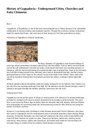
  • 1. History of Cappadocia - Underground Cities, Churches and Fairy Chimneys Part 3 Cappadocia, or Kapadokya, is one of the most interesting places in Turkey because of an unbeatable combination of natural wonders and manmade marvels. Through the centuries, human civilizations made the region their home, and each one put their stamp on it for later generations to enjoy. Formation of Cappadocia's Natural Landscape The fairy chimneys of Cappadocia were formed millions of years ago when surrounding volcanoes spewed lava into the valleys. Years of wind, rain and floods carved the soft sedimentary rock that lay under a hard basalt rock layer into towering minarets or chimneys, with the hard rock forming into mushroom-like caps or pointed tips. Some of the chimneys now look like strange animal forms and many were used as graveyards long ago. Another unique geological feature of the region is the natural curves of the walls of the valleys. These walls were carved by rainwater flowing from the plateaus and into the valleys, creating colorful ripple-like effects. All these splendid natural formations make the region inviting for hot air balloon rides. Visitors can not only view the stunning landscape from high, but the balloons can also thread through a maze of chimneys and peak through the window openings carved into the soft rock! Underground Cities Cappadocia was the perfect place of refuge in various points of its history as its unique landscapes provided its residents with ways to protect themselves from invaders and persecutors. The caves were in use since the Bronze Age as shelter from the elements and wild animals, while the Hittites were responsible for converting many into interconnecting rooms for their military and using the tunnels as defence systems. However, it was during early Christianity, when Romans persecuted Christ's followers, that those who came to Cappadocia saw the underground caves as potential temporary homes during Roman invasions. During the Byzantine era, they built self contained cities that could remain hidden and closed off from invaders for weeks at a time. There were kitchens, bathrooms, meeting rooms, storerooms, wine presses, stables and classrooms, all stocked with whatever was necessary for everyday living, as evidenced by the artifacts found during excavations.
  • 2. During the Ottoman Empire, when the region became an important point on the Silk Road, residents used their homes and cities to hide their wealth from passing marauders. The earliest written record dates some cities as far back as the http://www.bernoonsub.com 4th century BC. There are more than a hundred cities that have been found in this remarkable region, of which six are open to visitors. Some cities are small and rudimentary, while others go many floors down and were utilized for many purposes. Large and small rooms are connected by tunnels and bridges, and the numerous levels had air and water ducts running from the top to the bottom. Today, some of the more accessible rooms of many of the cities are still used by Cappadocia's inhabitants. The à ¹€à ¸šà ¸Â- - à ¸£à ¹Œà ¸ªà ¸§à ¸¢à ¸£à ¸²à ¸„à ¸²à ¸–à ¸¹à ¸à ¸¡à ¸²à ¸  entrances of most of these rooms conveniently open out into the courtyards of some residents here! Underground Cave Dwellings Open to Tourists Of the many underground cities that have been excavated, only six are currently open to tourists - Tatlarin, Mazikoy, Gaziemir, Ozkonak, Kaymakli, and Derinkuyu, with each one having something unique about it. The deepest of all the cities is Derinkuyu, which goes down 85 meters over 11 floors, but only eight have been completely excavated and less than half of that is open to visitors today. Of all the discovered cities in the region, this one is said to have been able to hold at least 20,000 people. A vertical staircase starts between the 3rd and 4th floor and goes all the way down to a church in the basement. A large 55 meter shaft also traverses through most of the floors to provide ventilation and water. This shaft did not open out directly to the surface so as to protect the residents from possible poisoning by invaders. Each floor could be completely closed off with heavy sliding rocks from the inside. Derinkuyu connects to the widest underground city, Kaymakli, via an
  • 3. https://www.facebook.com/bernoonsub eight kilometre underground tunnel. Kaymakli is spread over eight floors, of which four are open to the public. The structure of this city is different from that of Derinkuyu, as the tunnels are steeper and narrower, and rooms are clustered around the secondary ventilation shafts, while the main shaft traverses through most of the floors. This city has a high percentage of storage rooms, making historians believe that its inhabitants enjoyed economic prosperity. While Derinkuyu and Kaymakli attract the most visitors,there are others that are also good to visit and less crowded. Ozluce is spread over just one floor but is large in area. Its uniqueness lies in the various hues of its volcanic tuff rock and various other geological features. The underground city at Tatlarin is slightly newer as evidenced by the discovery of toilets. It may have been used more as a monastery or for military purposes rather than general living quarters. In Ozkonak, when entrances to each level were closed off for security reasons, small holes were used for ventilation. They were also used to pour hot oil on enemies or to spear them from above or below each level. Mazikoy and Gaziemir are smaller underground cave homes and barns that are also open for viewing. Cappadocia Churches When Christians first came to Cappadocia in the 1st and 2nd centuries, they found ideal rock-cut caves and underground cities that were first built during the Hittite era. They soon established monasteries and carried out clandestine religious practices in the safety of the landscape. They painted vivid icons on the cave walls, an activity that was briefly banned during the Iconoclastic period of the 8th century when the only art that was allowed were red geometric patterns. The frescoes that are visible in the rock-cut churches today were mostly from the Byzantine era. Many of the churches suffered some smoke damage, as they were also sometimes used as homes, and a few have sections that collapsed due to earthquakes and floods. However, many frescoes survived the damage and they include biblical scenes and depictions of saints.
  • 4. The open air museum in the Goreme valley of Cappadocia has the largest and best collection of monasteries and churches in one site and is a UNESCO World Heritage site. Many of the frescoes were uncovered only in the last few decades after layers of pigeon droppings and graffiti by local children hid the paintings from clear view. The paintings have been dated to the period between the 10th and 12th century. In addition to the Goreme open air museum, there are many other beautiful churches that dot the entire Cappadocian region. The biggest of them all is the St. John the Baptist church at Cavusin, with faded frescoes and cathedral-sized proportions. The churches at Urgup are thought to be among the area's oldest. The spectacular Ihlara Gorge, formed by the Melendiz River, has churches and a mosque cut into its walls. While the underground cities, churches and fairy chimneys are the most important sites to see in Cappadocia, there are many more that should not be https://www.facebook.com/bernoonsub missed. The highest point in Cappadocia is the Uchisar Castle, once a rock-cut tenement of living quarters that extended all the way up the cliff. The view from here includes all of Goreme. The Caravanserais that were built during the Seljuk and Ottoman eras served as roadside inns and mosques for merchants trading along the Silk Road. They were built from volcanic stone and decorated with carvings in geometric patterns, animal and flower motifs. To round off the Cappadocian experience, visitors can stay in one of the numerous boutique cave hotels and resorts in the region. Some are rustic and ideal for backpackers, while others feature all modern amenities. So, the next time you're planning a trip to Turkey, be sure to make Cappadocia a major stop on your itinerary. Fly into the area via Kayseri and explore everything this magical region
  • 5. has to offer. Read all about the history of Cappadocia, from prehistoric and Christian eras to the later Muslim eras...