Drainages
•Descargar como PPTX, PDF•
6 recomendaciones•3,250 vistas

The document discusses the major river systems of India. It describes the Himalayan rivers as being perennial and fed by snowmelt, with the Indus, Brahmaputra, and Ganga being the major rivers. It then discusses the peninsular rivers, which are seasonal and flow dependent on rainfall. Some notable peninsular rivers mentioned are the Narmada, Tapi, Godavari, Krishna, and Kaveri. The document then provides more details on the courses and basins of several key rivers including the Indus, Brahmaputra, Ganga, Yamuna, Narmada, Godavari, Tapi, Mahanadi, and Kaveri.

Recomendados
Más contenido relacionado
La actualidad más candente
La actualidad más candente (19)
Similar a Drainages
Similar a Drainages (20)
Último
Último (20)
Drainages
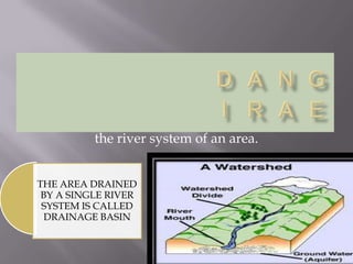
- 1. the river system of an area. THE AREA DRAINED BY A SINGLE RIVER SYSTEM IS CALLED DRAINAGE BASIN
- 2. The Himalayan river system They are Perennial. They have water throughout the year. They receive their water form rain as well as melted snow for the mountains. The major rivers the Indus, the Brahmaputra and Ganga. The rivers are long and have large volume of water. They cover a large land area. They perform intensive erosional activity form meanders, ox-bow lake, and delta. The Peninsular river system. They are seasonal and their flow is dependent on rainfall. Some of the rivers such as Narmada and Tapi originate in the Central highlands and westward but most for eastwards and drain into the Bay of Bengal They are short, and cover a comparatively short distance. They are seasonal rivers as they are drained by rains
- 3. A river along with its tributaries is known as river system
- 6. The Indus flows through Baltistan and Gilgit and emerges from the mountains at Attock . The Indus has a length of 2900 km which makes it one of the longest rivers Over a third of the Indus basin is located in India in the states of Jammu and Kashmir , Himachal Pradesh ,and Punjab and the rest in Pakistan
- 7. THE COURSE OF THE RIVER
- 8. It rises in Tibet east of Mansarovar lake. It flows eastwards parallel to the Himalayas. On reaching the Namcha Barwa it takes a U turn and enters India in ARUNACHAL PRADESH through a gorge. Here it called Dihang. It is joined by the Dibang , the Lohit ,and many other tributaries to form the Brahmaputra in Assam In Tibet it carries a smaller volume of water and silt as it is a cold and a dry area. I t passed the entire of Assam and form riverine islands
- 9. Every year during the rainy season , the river overflows its banks , causing widespread devastsation due to floods in Assam and Bangladesh . Unlike other north Indian rivers the Brahmaputra is marked by huge deposit of silt on its bed causing the river bed to rise . The river also shifts its channel frequently
- 11. The Course Of The River Ganga The headwaters of the Ganga, called the Bhagirathi is fed by the Gangotri Glacier and joined the Alaknanda at Devpryag in uttarkhand. At Haridwar the Ganga emerges from the mountains on the the plains. The Ganga is joined by many tributaries from Himalayas a few of them being major rivers such as the Yamuna, the Ghaghara the Gandak and Kosi
- 12. The river Yamuna rises from the Yamunotri Glacier in the Himalayas . It flows parallel to the Ganga and as a right bank tributary meets ganga at Allahabad . The Ghagra, the Gandak , and the Kosi rise in the Nepal Himalaya .The main tributaries from the peninsular uplands are the chambal,the betwa and the son . These rise from semi arid areas, have short courses and do not carry much water in them The ganga flows eastwards till Farakka in west bengal . This is the northern most point of the ganga delta . The length of ganga is over 2500km , Ambala is located on the water divide between the Indus and the ganga river systems . The plains from Ambala to the Sunderban stretch over nearly 1800km
- 15. The Narmada rises in the Amarkantak hill in Madhya Pradesh.It flows towards west in a rift valley formed due to faulting . The Marble rocks near Jabalpur; the river flows through a deep gorge. The Dhuadhar falls are great attractions in the Narmada Basin The narmada basin covers parts of madhya pradesh and gujarat
- 17. It is known as the Dakshin ganga because of its length and the area it covers. It is the largest PENINSULAR river. It rises in the slopes of the Western Ghats in the Nasik district and drains into the Bay of Bengal. It drainage basin covers parts of Maharashtra Madhya Pradesh, Orissa and Andhra Pradesh. It tributaries are Purna, the Waedha, pranhita, the Manjra, the Waiganga and Penganga Its length is about 1500km It drains into the Bay of Bengal . Its drainage basin is also the largest among the peninsular rivers .
- 18. It rises near Mahabeleshwar and flows for about 1400 km and reaches the Bay of Bengal. The Drainge basin is shared by Maharashtra, Karnataka and Andhra Pradesh. The tungabhadra , the koyana ,the ghatprabha , the musi, tribut and the bhima are some of its tributaries
- 20. The Tapi rises in the Satpura ranges in the Betul districts of Madhya Pradesh. It flows in a rift valley parallel to river Narmada. Basin covers parts of madhya pradesh ,gujarat, and maharashtra. The main west flowing rivers are sabarmati, mahi, bharatpuzha and periyar.
- 22. The Mahanadi rises in the highlands of Chattisgarh. It flows through Orissa to reach the bay of Bengal. the length of the river is 860 km . Its drainage basin is shared by Maharashtra, Chattisgarh, Jharkhand and Orissa
- 24. The Kaveri rises in the Brahmagiri range of the western ghats and it reaches the Bay of Bengal in south of Cuddalore , in Tamil nadu . Total length of the river is 760 km .Its main Tributaries are Amravati, Bhavani, Hemavati, an d Kabini . Its basin drains parts of karnataka, kearla and tamil nadu