2011 tōhoku earthquake and tsunami rwc work 東日本大震災 higashi ni
•
2 likes•447 views

K38 Japan and Mr. Hiroaki Kishi who began the program with his trusted colleagues worked in the aftermath of the Tohoku tsunami flood debris to help a community clear their waters to bring normalcy back to their lives.

Recommended
More Related Content
Similar to 2011 tōhoku earthquake and tsunami rwc work 東日本大震災 higashi ni
Similar to 2011 tōhoku earthquake and tsunami rwc work 東日本大震災 higashi ni (20)
More from K 38
More from K 38 (20)
Recently uploaded
Recently uploaded (20)
2011 tōhoku earthquake and tsunami rwc work 東日本大震災 higashi ni
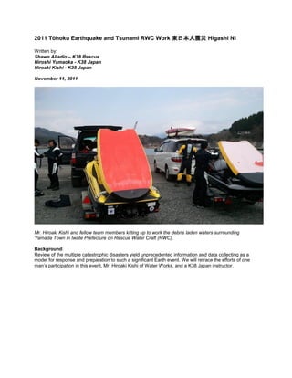
- 1. 2011 Tōhoku Earthquake and Tsunami RWC Work 東日本大震災 Higashi Ni Written by: Shawn Alladio – K38 Rescue Hiroshi Yamaoka - K38 Japan Hiroaki Kishi - K38 Japan November 11, 2011 Mr. Hiroaki Kishi and fellow team members kitting up to work the debris laden waters surrounding Yamada Town in Iwate Prefecture on Rescue Water Craft (RWC). Background: Review of the multiple catastrophic disasters yield unprecedented information and data collecting as a model for response and preparation to such a significant Earth event. We will retrace the efforts of one man’s participation in this event, Mr. Hiroaki Kishi of Water Works, and a K38 Japan instructor.
- 2. Yamada Town Burning History: Friday March 11, 2011 The Tohoku undersea mega thrust earthquake was a magnitude 9.0 which occurred at 14:46 and lasted th about 6 minutes. Large foreshocks had been reported, one measuring 7.2 on March 9 , with thousands of subsequent aftershocks, which may go on for years. The epicenter was approximately 70 kilometers east of the Oshika Peninsula of Tohoku and an underwater depth of 32 km. This was one of the 5 most powerful recorded earthquakes in world history since 1900. This earthquake triggered series of tsunami waves with significant run-up, which reached heights of 40.5 meters (133ft) in Miyako in Tohoku’s Iwate Prefecture, and in the Sendai area traveled up to 10 km (6 miles) inland. 38 prefectures were affected, over 125,000 buildings destroyed or severely damaged. With extensive structural damage to roads such as the Tohoku Expressway, airports, railways, homes, agriculture, fishing industry, businesses. The earthquake triggered a multitude of other immediate emergencies, the Fujinuma irrigation dam ruptured and subsequent fires destroyed many resources or caused delays in response. Telecommunications such as phone and internet were down. Matsushima Air Field of the Japan Self- Defense Force suffered flooding and damage, along with the Japan Coast Guard losing several boats. 549 Cultural Properties were damaged, including 5 National Treasures. Estimates range a total cost of $122 Billion for repairs, with 300,000 displaced persons which shall surely rise as the magnitude of recovery efforts are yet to be discovered. A nuclear disaster triggered ancillary disasters which compounded an already stressed emergency response community and became a global nuclear industry problem. The Onagawa Nuclear Power Plant experienced a fire in its turbine and was shut down. The number 2 reactor at the Tokai Nuclear power plant was shut down automatically. The Fukushima 1 Nuclear Power Plant experienced extreme damage and structural failure, resulting in the evacuation of surrounding communities and nuclear contamination. Fukushima 2 Power Plant located further south was later declared a state of emergency. Radiation levels were reported 1,000 times higher than normal.
- 3. Shinmoedake a Kyushu volcano erupted 2 days later further south. 20,000 people were killed, 6,000 injured and 4,000 people missing. The Cosmo Oil company refinery was set on fire, taking ten days to extinguish. The JX Nippon Oil & Energy refinery was set ablaze further worsening the fuel and electric needs of the nation and recovery efforts. 4.4 million Households were left without electricity and 1.5 without water during harsh winter conditions. An estimated 230,000 vehicles were destroyed or damaged. The earthquake moved Honshu 2.4 meters (7.9 feet) closer to the North Pacific and shifted the earth axis from estimates of 10 cm (4 inches and 25 cm (10 inches). A 400 km (250 mile) stretch of coastline dropped vertically by 0.6 meter (2.0 foot), allowing the tsunami waters to reach further inland. On April 6 the Japanese Coast Guard announced the earthquake shifted the seabed near the epicenter 24 meters (79 feet) and elevated the seabed off the coast of Miyagi prefecture by 3 meters (9 feet). The Earth’s rotation increased shortening the day by 1.8 microseconds due to the redistribution of its mass. The tsunami inundated a total area of approximately 561 km (217 square miles). Initial estimates calculated a tsunami this close could take 10-30 minutes to reach landfall. 101 designated tsunami evacuation sites were hit. In many communities soil liquefaction, uplift and subsidence occurred, the nominal concern is that subsidence is permanent and future flooding is possible at higher tides coastally. Numerous infrastructure failures and repairs were needed upon follow up inspections. The tsunami warning system that Japan has in place is considered the best in the world. The system is able calculate the height of tsunami within a quick 3 minute period based on modeling patterns of over 100,000 previous earthquake conditions. The Japan Meteorological Agency, however, admitted that the system was not capable of calculating beyond an 8.0 earthquake. Yamada Town Damage, large tanker placed inland. The first quake that hit was a 7.9 and within minutes, towns like Yamada were informed of a 5 meter
- 4. (approximately 16 feet) tsunami. The sea wall that was built here to protect the town close to the water was about that high. By the time the 9.0 quake hit and calculations were made for a much higher tsunami, it’s believed that most of the warning systems power was down or the people were not able to hear the new information announcing up to a 10 meter tsunami (30 feet). One minute prior to the earthquake being felt in Tokyo, the Earthquake Early Warning system which includes 1,000 seismometers in Japan, sent out warnings. 8 seconds after the first P wave was detected, or about 31 seconds after the earthquake occurred the general public was alerted. 92% of the victims recovered drowned, victims above the age of 65 accounted 65% of the deaths, and 24% being in their 70’s. Surrounding mountains of Yamada Town dusted with snow due to the harsh conditions of Winter. Yamada Town, Iwate Prefecture Yamada-machi is located on the northeast coast of Japan, about 150 miles north of Fukushima and about 50 miles south of Morioka. The railway line from these two places were initially destroyed therefore making access to Yamada difficult The coastal area along this region is curvy and jagged rocks with some of the world’s most beautiful inlets, harbors, peninsulas and islands. Yamada-machi is believed to been inhabited 6500 years ago. The first mention of the village in written material was in 715. In 1643 a Dutch shipped named ‘Breskans’ arrived in Yamada bay and landed on “Oshima” island to seek new supplies. Ten crew members were arrested and sent to court in Edo (Tokyo). The island of “Oshima” has since been named Orando-jima (Dutch island). th Yamada has experienced 3 prior historical tsunamis. In 1896 the Meiji-Sanriku on June 15 at 7:30pm while families were celebrating the return of soldiers from the First Sino-Japanese War and a Shinto Holiday. The magnitude of 8.5 which killed 22,066 people destroyed 9,000 homes and generated waves of 38.2 meters (115 feeet) in the region. Another one, the 1933 Sanriku earthquake occurred on March 2, with less casualties but lots of building
- 5. damage (18 killed and 12 injured). Water heights were recorded at 28.7 meters (94 feet) from a magnitude 8.4 located 290 kilometers offshore (180 miles). 1,522 people lost their lives, 1542 missing and 12,053 injured. On May 22, 1960, the largest earthquake in the world hit with a 9.5 magnitude. The Chilean Valdivia earthquake caused extensive run-up damage with 35 foot high waves and killed 142 people 22 hours after the initial quake. Ground Zero in Yamada Town, all that is left are the concrete foundations of a once thriving fishing community. The surges that occurred here were fierce and unrelenting. Yamada had a population of around 20,000 people. After the disaster in March, 1,882 people were homeless, with another 167 unable to feed themselves. There were initially 670 reported dead, 148 still not found, and another115 unidentified. The entire town was not affected due to higher elevation levels. The city hall, schools and some homes were untouched. Yamada town faces many challenges, the initial losses being horrific and the survivors living in shelters detached from the lives they led. Health care was disrupted and nutritional needs compromised. Survivors dug through the mud searching for pieces of their lives. Survivors needed help and were questioning the response support, a questioned posed too many of the responding volunteers.
- 6. Yamada Town The Implementation of Rescue Water Craft (RWC) th Recovery Working Dates: April 28-May 5 Location: Prefecture Iwate, Yamada Town Recovery Vessels: 2 PWC-s Sea Doo GTX four strokes, Yamaha SHO- IRB, rescue boards Water Temperature: 45 degrees (air temperature 62)
- 7. NPO Team: Tomofumi Oda, Taishi Otono (team leader), Eiichi Ishii, Arata Murakami, Hiroaki Kishi, and two others. Mr. Otono Taishi was the Leader of the NPO ResponseTeam. He established the NPO which bears the namesake, Okinawa Water Patrol System which consists of a Lifeguard Team. They applied their program to the Nippon Foundation for support efforts in the field for this mission. The Yamada mission was thence funded and the team readied for the tasks ahead. They organized their equipment and transportation needs; 2 RWC’s and 1 IRB and a total of seven people mobilized with their resources and headed to the disaster zone. Yamada Town Volunteer Center and 2011 Recovery Efforts The widespread damages and reduction in recovery services, resources and personnel produced a varied response and timeline throughout this region. The surviving families needed to recovered their loved ones physical remains, rebuild and get their livelihoods established so they could move forward. This area had a historically strong background in fisheries, a hearty and resilient people who have seen the face of disaster before. Removing the debris from water and land posed many obstacles, both from a resources concern and a psychological impact of both the citizens and responders. The overwhelming sense of hopelessness matched a slow pace of recovery. This area was known for its aquaculture, the bays providing a perfect place for raising oysters in
- 8. suspended production beds. Many farmed from the sea, total destruction yielded the loss of oyster and seaweed businesses and all the supporting equipment was strewn in an abstract mess inland, wrapped in debris piles or drawn out to sea. The main roads were initially cleared by the Japanese government, but years of cleanup lay ahead, debris and rubble piled up into stacks 10 meters high. The geographical terrain, the fetch of the tsunami waves and subsequent currents reached 30 feet or 10 meters in this region. The forces of action with the surging waters funneled a wedge effect as the waters merged with the pitch of the surrounding jagged shoreline. This created a focal point of the coastline in this area that accentuated specific zones as targeted low lying flood plains, that otherwise would have been considered protected harbors. The wedge effect forced rising waters to increase their speeds as they doubled along the pointed shorelines and forcing the debris flows like a frontal hammer. The destruction left only the remains of twisted metal frames, and cleared concrete foundations. Divers had been searching in the debris laden waters for the physical remains of their lost family members and to assist in the removal of debris piles. These divers risked their lives searching for loved ones and taking account of the underwater debris removal. Homes were lying underneath displaced suspended oyster beds with victims trapped inside the dwellings. The debris piles posed a significant risk to the workers of the recovery efforts below the surface and above. The surrounding shoreline around the prefecture are great fishing grounds due to the underwater geographical terrain and rich nutrients brought by the colder Oyashio current from north and warmer Kuroshio current from south where they converge. The recovery of the fishing industry was paramount to the surviving community members and their families. The fishermen needed outside assistance to clear the debris and household/industry items strewn along these coastal communities. Their fishing vessel fleet was significantly damaged and they were incapable of clearing this zone alone.
- 9. Soon, the NPO-Non Profit Organization was working at organizing RWC use at this site to assist in the needs of this community. The NIPPON Foundation donated funds for NPO to administer the logistical needs. Mr. Hiroaki Kishi was one of the members of this team. It takes time to organize and muster approvals and funding, the logistical needs during a catastrophic even can be quite daunting. Hiroaki Kishi arrived via ferry from Hokkaido, Japan’s second largest island surrounded by three coastlines consisting of the Sea of Japan, the Sea of Okhotsk and the Pacific Ocean. Known for cool summers and icy winters, the people from here are a hearty lot. Hiroaki is a seasoned lifeguard and a RWC instructor. He observed an extremely high level of debris which was floating and submerged near the surface in the ocean during the ferry transit which bore his RWC, trailer and vehicle. The ferry had to navigate cautiously along the coast as it moved closer to the tsunami epicenter and mainland. Facing these first warning signs the significance of the disaster was quite apparent to him, even though a month had passed.
- 10. The Yamada City Hall had a billboard where people left notes for missing loved ones in hope of a miraculous reunion. In another room search teams had placed photo albums they found in the rubble. The mayor worked out of the second floor, he also lost his home. Many residents faced burdens beyond the psychological trauma. Insurance would be difficult to prove with all vital records being destroyed or washed away. If the flood waters did not destroy, the ensuing fires created a second surge of disaster. Buildings over 20 meters on high ground were saved. The weather conditions were often freezing, snow was not uncommon at this time and a recent blizzard had just struck. Fuel vouchers were issued and gas was scarce making this vital resource a difficult strategy for equipment needs. At first Mr. Kishi thought there was little capability to use a PWC in the aftermath of this disaster. Upon arrival he began to assess the situation closer, how could they be effective in such a big area? They listened to the fishermen concerns, a plan was soon drafted. After the earthquake the fishermen worked very hard to clear the oyster plant beds.
- 11. The larger fishing boats could not attempt the confined spaces needs because the fishing boats were not easy to maneuver and were too high from the waterline to work with debris recovery and removal. This made their work dangerous, as they cleared the debris piles more remains were found, which at times slowed progress down out of concern for body recovery. Their subsequent pace was slow and frustrating. On-water confined spaces and tight quarters proved the Rescue Water Craft was a perfect fit for the problem at hand. Kishi realized that the PWC was the best vessel to approach this concern. Once the fishermen observed the work of the team getting underway, they began to realize the value this type of vessel would do to assist them. With extension ropes tied off the stern cleat of the PWC they began to work the higher risk zones. Towing out of tight quarters and clearing many debris items, such as complete houses, rooftops and vehicles which they were not expecting to find initially, the team kept at it. Calls went out to Police and Coast Guard when they came across a body, and they began searching the cars and buildings for the physical remains of victims from this tragedy as they cleared this plots on water, efforts shifted to land.
- 12. Before the NPO team arrived, the local fishermen worked hard on their own with their larger vessels to get their waters cleared, but their work done in one week was accomplished comparably in one day by the RWC team. Timelines became increasingly faster for this goal. This was immediately obvious to everyone present and greatly appreciated. As the wind and tides shifted their directional flows, these complimentary currents would quickly bring into close quarters along the shoreline. These debris fields bore every type of physical remains of what used to be viable products used in everyday life. At several of the team’s deployment locations, the surface waters appear clear, but the near surface conditions of debris trapped the team when conditions shifted. They learned to keep a closer watch on all their on-water movements. Water entry could be hazardous and life threatening in such unstable conditions.
- 13. The area their team worked was a very large water acreage of a harbor or bay (gulf). There were 120 of these suspended oyster beds sized at 60’x50’, which was all piled up into a large mess by the tsunami waters. He was only able to see 20 oyster beds initially, the rest were destroyed or underwater and unaccounted for. Perhaps some washed out to sea and joined a flotilla of open water debris and floating islands. The fishermen wanted to get their oyster production of aquaculture up and running immediately. But first searches needed to be conducted underneath these original plots. Once the RWC’s arrived it became more evident that they could clear these zones and get their operations back up and running sooner. The team worked there for 8 days supporting the fishermen in the community. During this time they searched the entire original plot covering 1,600 oyster beds former zones of operation.
- 14. Once these searches began in these zones and were plotted and cleared, their search was closed down and they would move to another location. After 4PM they worked on the land searching the strewn nets, buildings or warehouses keeping in mind that either direction progress was moving, even though it appeared overwhelming. Each day a local woman came to the water’s edge hoping for news of her lost family members, deeply touching the team and furthering their resolve. Helpless feelings at the enormity of the situation were ever present. More RWC’s, boats, fuel and manpower were needed. Checked buildings, vehicles and boats were spray painted with ‘OK’ after search was completed.
- 15. Secondary Victims These areas are best known in the Japanese fishing industry. Worldwide and regionally restaurants rely on the industry of this region. The historical significance of traditional fishing didn’t embrace the RWC usage, until the impact was clear; the best work horse for this situation was the access providing for RWC for clearing debris piles. Trust was built through the mutual efforts of both groups. There was a high level of appreciation that complimented the needs of the fishing community. Without the reinstatement of their work, the community would further decline for the secondary wave of destruction, the economics of recovery for survivors in catastrophic events.
- 16. This woman searched daily for her missing family members. Here she is shown with the team, checking in with them for any news. The needs of the community and responders are myriad and complicated but inclusive to safety, health and recovery. Both groups live with the results of their situation and efforts. The survivors have to deal with issues of grief and concerns for their welfare, and responders the feeling of never doing enough for the survivors. Collaboration was necessary to build trust and work within this community. Respect was vital to progress on an emotional level. The initial feelings of resentment by the local community for not receiving faster support were evident to the responders. The respect earned was through the committed efforts that achieved the immediate results the local fishermen were in dire need of. The fastest way to recover is to help survivors get back to the life they once knew. Being productive supports emotional well-being and allows people to take care of their basic needs. References: Volunteer Diver Blog: http://blog.goo.ne.jp/fishman_2007/e/bacbdbb5fcd53d505f46e29d7b35c6e8Wikipedia: http://ja.wikipedia.org/wiki/%E3%83%95%E3%82%A1%E3%82%A4%E3%83%AB:KuroshioOyash io.jpg Yamada-Before and after photos:http://www.yamada-kankou.jp/info/photorepo/index.html
- 17. http://www.K38Japan.com RECOVERY INSIGHTS Just as in the past, historical accounts of fishermen at sea returning home to complete devastation and loss did not feel the effects at sea, save for strange currents moving in the waters below. Some fishermen were able to get their boats out to sea offshore and save their vessels, returning to the harbor the views of destruction and debris slowed down their appoach. The Japanese fishing industry in these regions were devastated. Kishi's team suiting up and getting ready to deploy their SeaDoos Visit google maps and check out the elevations and surrounding geographical terrain in this region, you can view the rich fishing history of how it begins on land. Follow the rise of the surrounding land masses into the mountains and the feeder washes, creeks and rivers. Check out the meridian line location and view the craggy coastline. Oyster farming is perfect for the natural settings, melted snow ice water bringing down rich nutrients and minerals into Yamada Bay. However this terrain is very susceptible to the invasion of waters from tsunami immersion, with the th undersea earth activity, which is some of the most active on the globe. On March 11 , where Yamada town was built public buildings were washed away or destroyed by fire. A shelter was swept away from this historic tsunami referred to as ‘311’.
- 18. Yamada Town March 23rd Snowfall Twelve persons lost their lives at the shelter. Official records state that the shelter was built on high ground 50 meters above sea level. The world’s highest and most capable and cutting edge designed sea wall were not enough to protect human life from the power of the sea. Reality shifts from historical perspective. If we gauge off of a past event, but do not include probable events, shelter locations may not be functional, in fact possibly deadly. The Wisdom of through the ages of folklore that has been passed on from father to son throughout the generations saved a lot of people from the realities of Earth events in this region. There is a dialogue that has sustained this wisdom from the people who live around the Sunriku shorelines that is remembered all these years. ‘Tsunami Tendenko’, which means ‘Survive Yourself’.
- 19. Minamisanrik Town, floodwaters in the forrest line If a huge earthquake occurs, ‘run on your own’. Don’t wait for anybody. Seek higher ground. Don’t take anyone’s hand. Don’t look back. Saving yourself means saving others. This actually worked very well on 3-11. It is sad, and safe advice and makes sense. Survival instincts are basic preservation and a hard reality to face when you are standing at ground zero. The 311 image resonates with the United States of America terrorist attacks on 911. The first attack and the secondary attacks, survival and survivors recovery are similar aspects of disasters that have specific timelines and actions. There is an old stone monument left for future generations as a warning and a lesson to heed from past experience. It is over a hundred years of age. It says ‘Don’t build houses beyond this point to the sea’. The stone is high in the forest inland away from the sea. It is a timeline marker from a past historical account. The tsunami waters at after the time of placement created the runup effect far inland. It stopped in the forest right before the location this stone was placed at. Amazing!101 designated shelters were hit by the tsunami effects.
- 20. OTSUCHI, Japan - Kogan Temple is seen devastated in the town of Otsuchi, Iwate Prefecture, on March 31, 2011, by the March 11 tsunami. At least 30 people who took shelter at the Buddhist temple went missing. They had gathered there as the building nearly 1 kilometer from the sea was designated as a tsunami evacuation facility. The temple also suffered a fire after the disaster. More than 100 designated shelters were hit by the tsunami. (Kyodo) The leadership roles and guidance were the most important decisive actions that took place in human escape routes and choices in this catastrophic event. The tragedies at the Okawa elmenentary school and he Hasegawa Kindergarten school in Ishinomaki City are reminders of this. The Okawa Elementary school had 50 minutes warning from the onset of the earthquake to the first strike on the oncoming tsunami wave.As valuable time was passing, the teachers held their students outside in the school yard. When they finally made the decision to move, they took their students in the wrong direction to safety. Instead of heading for the mountain, they headed to the nearest high bridge over the Okawa River. 68 students perished out of 108 in the surging debris laden waters.At Hasegawa Kindergarten, the teachers there sent two buses full of infants to their homes after the earthquake struck. One bus decided to stop when the driver heard the alert of a tsunami from the radio. Another bus continued onward but heading into the direct path of tsunami waters. After the first wave strikes, the infants are still alive inside the bus. The teachers couldn’t do anything, most of these infants died in the ensuing fire that occurred near the bus location, trapped. The Kindergarten in Hasegawa had no damage from the tsunami, because it is on high ground. The infants could have stayed safely there from the onset of the tragedy. Poor leadership decisions, lack of effective use of time and a strategic tsunami evacuation plan were not effective for these young victims and their charges. When the executive manager of the Sato Fishery Company in Onagawa Town, which recently accepted 20 trainees from China, the manager immediately decided to take his Chinese apprentices to the Shinto Shrine high on the mountain that was located directly behind the company headquarters. All the Chinese apprentices arrive safely back in China after the disaster. He was their hero and lifesaver. Unfortunately he died in the tsunami surging waters when he went back to look for people who remained in the company on a search mission.
- 21. Kishi's team working at clearing these oyster beds Japanese tsunami warning system: http://www.seisvol.kishou.go.jp/eq/eng/fig/info.html http://www.seisvol.kishou.go.jp/eq/e...nfo.html#info5 Vivid images of Yamada town http://tetunakaya.o.oo7.jp/indexharu20110515.html http://mmmorioka.exblog.jp/12357801/ http://mmmorioka.exblog.jp/12377420/ http://mmmorioka.exblog.jp/12397197/ http://mmmorioka.exblog.jp/12427702/ Under water images of Yamada town: http://blog.livedoor.jp/npoudn/archives/3283699.html
- 22. Kishi's team helping in Yamada Town to clear the waters, here a large strand of fishing nets are being recovered. Here are some great links to background information of Yamada Town. Check these out: http://www.town.yamada.iwate.jp/04_k...y-english.html http://www.town.yamada.iwate.jp/04_k...a-english.html Mr. Hiroaki Kishi ******************************** Waterworks 〒007-0870 Fushiko10-1-13-8 Higashi-ku Sapporo Hokkaido Japan Hiroaki Kishi TEL:011-786-6354 fax :050-7515-7582 URL: www.k37waterworks.com mail: info@k37waterworks.com force38japan@gmail.com
- 23. K38 Japan - RWC Instructor _________________________________________________