SlideShare una empresa de Scribd logo
1 de 58
Descargar para leer sin conexión
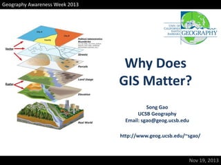
Geography Awareness Week 2013

Why Does
GIS Matter?
Song Gao
UCSB Geography
Email: sgao@geog.ucsb.edu
http://www.geog.ucsb.edu/~sgao/

Nov 19, 2013
GIS in Daily Life

Wayfinding, Navigation, Location-based Search and Decision Making
Content

•
•
•
•

What is GIS?
GIS Applications
How has it been used in science
Trends

Nov 19, 2013, Song Gao
What is GIS?
A geographic information system (GIS) integrates hardware,
software, and data for capturing, managing, analyzing, and
displaying all forms of geographically referenced information.
GIS allows us to view, understand, question, interpret, and visualize
data in many ways that reveal spatial relationships, patterns, and
trends in the form of digital maps, globes, reports, and charts.

Nov 19, 2013, Song Gao
Three Views of GIS
Database

GIS
Analysis

Visualization
(1) GIS as GeoDatabase
• Geodatabase: a spatial database containing data
that associate with geographic information.

Attributes + Geometry
http://www.census.gov/geo/maps-data/data/tiger.html
(2) GIS as GeoVisualization
• Geovisualization: a set of intelligent maps and
other views that shows features and feature
relationships on the earth's surface.
Mapping Every McDonald's in the U.S.
Starbucks vs. Dunkin Donuts

http://www.boston.com/yourtown/specials/starbucks_vs_dunkin_donuts/
(3) GIS as Spatial Analysis
• Geoprocessing: a set of tools take geographic
information from existing data, apply spatial
analysis functions to identify patterns or discovery
knowledge.

P.A. Longley, M.F. Goodchild, D.J. Maguire, and D.W. Rhind (2011) Geographical Information Systems and Science. Third Edition. Hoboken,
NJ: Wiley.
Find the “Hot Spot” Regions
Content

•
•
•
•

What is GIS?
GIS Applications
How has it been used in science
Trends

Nov 19, 2013, Song Gao
What things
do you think
are related to
GIS?
The Canada Geographic Information
System
• Roger Tomlinson
– IBM contracts 1964-68

• 7 layers of land characteristics
–
–
–
–

soil capability for agriculture
recreation capability
current land use
….

• To assess the current use of Canadian land
– to measure area, plan new uses
Esri UC 2011
Natural Resources Management

Esri UC 2011
Esri UC 2011
Delivery Route Planning
Esri UC 2011
Geospatial data and tools have the potential
to contribute to the saving of lives, the
limitation of damage, and reduction in the
costs to society of dealing with emergencies
Typhoon Haiyan/Yolanda GIS
Hurricane Sandy Tweetbeat

http://www.youtube.com/watch?v=g3AqdIDYG0c

SGI
Google Earth
Discrete global grid based on the
Icosahedron (20 triangles, 1:4
recursive subdivision)
Ross Heikes and David Randall,
Colorado State University

Question:
How to divide the
globe into different
levels of details?
Content

•
•
•
•

What is GIS?
GIS Applications
How has it been used in science
Trends

Nov 19, 2013, Song Gao
Source: Gilbert E. W. 1958 ‘Pioneer maps of health and disease in England.’ Geographical Journal, 124: 172–183
Terrain Viewshed Analysis
• A viewshed is an environmental area that is visible
to the human eye from a fixed point.
Terrain Viewshed Analysis
Noise Assessment

http://gis.stackexchange.com/questions/54696/how-to-create-noise-maps-open-source-orscripted-in-arcgis
Human
Study

Social
Science

Environment

Spatially Integrated Social Science
http://www.csiss.org/
History and Archaeology
Overlap Layers

Digitizing features for excavations
GIS to identify social divide
Information Age
• Location Awareness Devices(Mobile Phone、GPS)
• Large scale spatio-temporal datasets
Tracking the $ dollar bills

http://rocs.northwestern.edu/clips/
Phone call patterns in different places

AM 03-04

AM 06-07

PM 15-16
PM 18-19
http://www.spatial.ucsb.edu/events/local13/posters.php

AM 09-10

PM 21-22
By Song Gao
Mobile Landscape:
People in MIT SENSEable City Lab have developed a continuously changing realtime maps of cell phone usage in Graz, Austria.

http://senseable.mit.edu/grazrealtime/
Content

•
•
•
•

What is GIS?
GIS Applications
How it has been used in science
Trends

Nov 19, 2013, Song Gao
Online GIS

Access GIS techniques without installing any software
on your computers.
Cloud GIS/ Mobile GIS
3D-GIS
Space-Time GIS
The GPS tracks of individuals in
spatio-temporal space

Regular
Irregular
by Song Gao
Volunteered Geographic Information
(VGI)
• Citizens as sensors: the world of volunteered
geography – by Professor Michael F. Goodchild

www.wikimapia.org
www.openstreetmap.org
OpenStreetMap Edits in US

Created by ITO World
Mapping Social Media

by Paul Butler
https://www.facebook.com/notes/facebook-engineering/visualizing-friendships/469716398919
Crandall et al. 2009. Mapping the world’s photos.
http://www.cs.cornell.edu/~crandall/papers/mapping09www.pdf
Dots
Yellow: Photos
Blue: Tweets
White: Both

by Erik Fischer
http://www.flickr.com/photos/walkingsf/sets/72157627140310742/
Tracks inferred from Flickr postings
(http://www.cs.cornell.edu/~crandall/papers/mapping09www.pdf)
See also http://www.flickr.com/photos/walkingsf/sets/72157624209158632/
Spatial is special,
To know the unknown!
http://www.geog.ucsb.edu/~sgao/

Más contenido relacionado

La actualidad más candente

Introduction to arc gis
Introduction to arc gisIntroduction to arc gis
Introduction to arc gisMohamed Hamed
 
GIS.INTRODUCTION TO GIS PACKAGES &GEOGRAPHIIC ANALYSIS
GIS.INTRODUCTION TO GIS PACKAGES &GEOGRAPHIIC ANALYSISGIS.INTRODUCTION TO GIS PACKAGES &GEOGRAPHIIC ANALYSIS
GIS.INTRODUCTION TO GIS PACKAGES &GEOGRAPHIIC ANALYSISTessaRaju
 
Spatial analysis and modeling
Spatial analysis and modelingSpatial analysis and modeling
Spatial analysis and modelingTolasa_F
 
Basic of gis concept and theories
Basic of gis concept and theoriesBasic of gis concept and theories
Basic of gis concept and theoriesMohsin Siddique
 
Digital Elevation Models
Digital Elevation ModelsDigital Elevation Models
Digital Elevation ModelsBernd Flmla
 
Introduction to GIS systems
Introduction to GIS systemsIntroduction to GIS systems
Introduction to GIS systemsVivek Srivastava
 
Difference between gis and cad
Difference between gis and cadDifference between gis and cad
Difference between gis and cadSumant Diwakar
 
Geo referencing by Mashhood Arif
Geo referencing by Mashhood ArifGeo referencing by Mashhood Arif
Geo referencing by Mashhood ArifKU Leuven
 
Lec_6_Intro to geo-referencing
Lec_6_Intro to geo-referencingLec_6_Intro to geo-referencing
Lec_6_Intro to geo-referencingAtiqa khan
 
Introduction and Application of GIS
Introduction and Application of GISIntroduction and Application of GIS
Introduction and Application of GISSatish Taji
 
What is Geography Information Systems (GIS)
What is Geography Information Systems (GIS)What is Geography Information Systems (GIS)
What is Geography Information Systems (GIS)John Lanser
 
GIS and QGIS training notes
GIS and QGIS training notesGIS and QGIS training notes
GIS and QGIS training notesArnold Kilaini
 
Introduction to GIS
Introduction to GISIntroduction to GIS
Introduction to GISJoey Li
 

La actualidad más candente (20)

A short introduction to GIS
A short introduction to GISA short introduction to GIS
A short introduction to GIS
 
Introduction to arc gis
Introduction to arc gisIntroduction to arc gis
Introduction to arc gis
 
GIS.INTRODUCTION TO GIS PACKAGES &GEOGRAPHIIC ANALYSIS
GIS.INTRODUCTION TO GIS PACKAGES &GEOGRAPHIIC ANALYSISGIS.INTRODUCTION TO GIS PACKAGES &GEOGRAPHIIC ANALYSIS
GIS.INTRODUCTION TO GIS PACKAGES &GEOGRAPHIIC ANALYSIS
 
Spatial analysis and modeling
Spatial analysis and modelingSpatial analysis and modeling
Spatial analysis and modeling
 
Basic of gis concept and theories
Basic of gis concept and theoriesBasic of gis concept and theories
Basic of gis concept and theories
 
GIS
GISGIS
GIS
 
gis
gisgis
gis
 
Digital Elevation Models
Digital Elevation ModelsDigital Elevation Models
Digital Elevation Models
 
Urban planing & gis
Urban planing & gisUrban planing & gis
Urban planing & gis
 
Introduction to GIS systems
Introduction to GIS systemsIntroduction to GIS systems
Introduction to GIS systems
 
Geographical Information System (GIS)
Geographical Information System (GIS)Geographical Information System (GIS)
Geographical Information System (GIS)
 
Difference between gis and cad
Difference between gis and cadDifference between gis and cad
Difference between gis and cad
 
Mobile gis
Mobile gisMobile gis
Mobile gis
 
Geo referencing by Mashhood Arif
Geo referencing by Mashhood ArifGeo referencing by Mashhood Arif
Geo referencing by Mashhood Arif
 
Lec_6_Intro to geo-referencing
Lec_6_Intro to geo-referencingLec_6_Intro to geo-referencing
Lec_6_Intro to geo-referencing
 
Introduction and Application of GIS
Introduction and Application of GISIntroduction and Application of GIS
Introduction and Application of GIS
 
What is Geography Information Systems (GIS)
What is Geography Information Systems (GIS)What is Geography Information Systems (GIS)
What is Geography Information Systems (GIS)
 
introduction to GIS
introduction to GIS introduction to GIS
introduction to GIS
 
GIS and QGIS training notes
GIS and QGIS training notesGIS and QGIS training notes
GIS and QGIS training notes
 
Introduction to GIS
Introduction to GISIntroduction to GIS
Introduction to GIS
 

Similar a Why Does GIS Matter

FULLYFINAL GIS CHOUBEYJI.pptx
FULLYFINAL GIS CHOUBEYJI.pptxFULLYFINAL GIS CHOUBEYJI.pptx
FULLYFINAL GIS CHOUBEYJI.pptxAkashBhagat34
 
Gi science discipline_foloo
Gi science discipline_folooGi science discipline_foloo
Gi science discipline_foloooloofrank
 
2013 liasa poster putting gis librarianship on the south african map_online
2013 liasa poster putting gis librarianship on the south african map_online2013 liasa poster putting gis librarianship on the south african map_online
2013 liasa poster putting gis librarianship on the south african map_onlineLinda_Kelly
 
Geograpic Information Systems
Geograpic Information SystemsGeograpic Information Systems
Geograpic Information SystemsChristina Sookdeo
 
Geographic Information Systems (GIS).pptx
Geographic  Information Systems (GIS).pptxGeographic  Information Systems (GIS).pptx
Geographic Information Systems (GIS).pptxEllenGracePorras
 
Topic Introduction to GIS and its Applications.pptx
Topic Introduction to GIS and its Applications.pptxTopic Introduction to GIS and its Applications.pptx
Topic Introduction to GIS and its Applications.pptxAneeqaa Abrar
 
Gis Day Presentation 2010 - ACCC - Expanded Version
Gis Day Presentation 2010 - ACCC - Expanded VersionGis Day Presentation 2010 - ACCC - Expanded Version
Gis Day Presentation 2010 - ACCC - Expanded Versionpdcaris
 
Geographic Information System.pdf
Geographic Information System.pdfGeographic Information System.pdf
Geographic Information System.pdfSandesh Bandal
 
GIS: Bringing Geography to the World & the World to Geography
GIS: Bringing Geography to the World & the World to GeographyGIS: Bringing Geography to the World & the World to Geography
GIS: Bringing Geography to the World & the World to GeographyBarry Wellar
 
A quick overview of geospatial analysis
A quick overview of geospatial analysisA quick overview of geospatial analysis
A quick overview of geospatial analysisMd.Farhad Hossen
 
Introduction to Geographic Information system and Remote Sensing (RS)
Introduction to Geographic Information system  and Remote Sensing (RS)Introduction to Geographic Information system  and Remote Sensing (RS)
Introduction to Geographic Information system and Remote Sensing (RS)chala hailu
 
Spatial Analysis and Geomatics
Spatial Analysis and GeomaticsSpatial Analysis and Geomatics
Spatial Analysis and GeomaticsRich Heimann
 
GIS: Bringing Geography to the World & the World to Geography; Slide Presenta...
GIS: Bringing Geography to the World & the World to Geography; Slide Presenta...GIS: Bringing Geography to the World & the World to Geography; Slide Presenta...
GIS: Bringing Geography to the World & the World to Geography; Slide Presenta...Barry Wellar
 
Essays on Geography and GIS, Vol. 2
Essays on Geography and GIS, Vol. 2Essays on Geography and GIS, Vol. 2
Essays on Geography and GIS, Vol. 2Esri
 

Similar a Why Does GIS Matter (20)

FULLYFINAL GIS CHOUBEYJI.pptx
FULLYFINAL GIS CHOUBEYJI.pptxFULLYFINAL GIS CHOUBEYJI.pptx
FULLYFINAL GIS CHOUBEYJI.pptx
 
GIS KD.pdf
GIS KD.pdfGIS KD.pdf
GIS KD.pdf
 
Gi science discipline_foloo
Gi science discipline_folooGi science discipline_foloo
Gi science discipline_foloo
 
2013 liasa poster putting gis librarianship on the south african map_online
2013 liasa poster putting gis librarianship on the south african map_online2013 liasa poster putting gis librarianship on the south african map_online
2013 liasa poster putting gis librarianship on the south african map_online
 
Geograpic Information Systems
Geograpic Information SystemsGeograpic Information Systems
Geograpic Information Systems
 
Geographic Information Systems (GIS).pptx
Geographic  Information Systems (GIS).pptxGeographic  Information Systems (GIS).pptx
Geographic Information Systems (GIS).pptx
 
Topic Introduction to GIS and its Applications.pptx
Topic Introduction to GIS and its Applications.pptxTopic Introduction to GIS and its Applications.pptx
Topic Introduction to GIS and its Applications.pptx
 
Gis Day Presentation 2010 - ACCC - Expanded Version
Gis Day Presentation 2010 - ACCC - Expanded VersionGis Day Presentation 2010 - ACCC - Expanded Version
Gis Day Presentation 2010 - ACCC - Expanded Version
 
Geographic Information System.pdf
Geographic Information System.pdfGeographic Information System.pdf
Geographic Information System.pdf
 
GIS: Bringing Geography to the World & the World to Geography
GIS: Bringing Geography to the World & the World to GeographyGIS: Bringing Geography to the World & the World to Geography
GIS: Bringing Geography to the World & the World to Geography
 
GIScience_all.pdf
GIScience_all.pdfGIScience_all.pdf
GIScience_all.pdf
 
GIS in Civil Engineering
GIS in Civil EngineeringGIS in Civil Engineering
GIS in Civil Engineering
 
A quick overview of geospatial analysis
A quick overview of geospatial analysisA quick overview of geospatial analysis
A quick overview of geospatial analysis
 
Smart Citizens
Smart CitizensSmart Citizens
Smart Citizens
 
Smart Citizens
Smart CitizensSmart Citizens
Smart Citizens
 
Gis
GisGis
Gis
 
Introduction to Geographic Information system and Remote Sensing (RS)
Introduction to Geographic Information system  and Remote Sensing (RS)Introduction to Geographic Information system  and Remote Sensing (RS)
Introduction to Geographic Information system and Remote Sensing (RS)
 
Spatial Analysis and Geomatics
Spatial Analysis and GeomaticsSpatial Analysis and Geomatics
Spatial Analysis and Geomatics
 
GIS: Bringing Geography to the World & the World to Geography; Slide Presenta...
GIS: Bringing Geography to the World & the World to Geography; Slide Presenta...GIS: Bringing Geography to the World & the World to Geography; Slide Presenta...
GIS: Bringing Geography to the World & the World to Geography; Slide Presenta...
 
Essays on Geography and GIS, Vol. 2
Essays on Geography and GIS, Vol. 2Essays on Geography and GIS, Vol. 2
Essays on Geography and GIS, Vol. 2
 

Último

Nell’iperspazio con Rocket: il Framework Web di Rust!
Nell’iperspazio con Rocket: il Framework Web di Rust!Nell’iperspazio con Rocket: il Framework Web di Rust!
Nell’iperspazio con Rocket: il Framework Web di Rust!Commit University
 
Designing IA for AI - Information Architecture Conference 2024
Designing IA for AI - Information Architecture Conference 2024Designing IA for AI - Information Architecture Conference 2024
Designing IA for AI - Information Architecture Conference 2024Enterprise Knowledge
 
DSPy a system for AI to Write Prompts and Do Fine Tuning
DSPy a system for AI to Write Prompts and Do Fine TuningDSPy a system for AI to Write Prompts and Do Fine Tuning
DSPy a system for AI to Write Prompts and Do Fine TuningLars Bell
 
DevoxxFR 2024 Reproducible Builds with Apache Maven
DevoxxFR 2024 Reproducible Builds with Apache MavenDevoxxFR 2024 Reproducible Builds with Apache Maven
DevoxxFR 2024 Reproducible Builds with Apache MavenHervé Boutemy
 
WordPress Websites for Engineers: Elevate Your Brand
WordPress Websites for Engineers: Elevate Your BrandWordPress Websites for Engineers: Elevate Your Brand
WordPress Websites for Engineers: Elevate Your Brandgvaughan
 
"Debugging python applications inside k8s environment", Andrii Soldatenko
"Debugging python applications inside k8s environment", Andrii Soldatenko"Debugging python applications inside k8s environment", Andrii Soldatenko
"Debugging python applications inside k8s environment", Andrii SoldatenkoFwdays
 
Vertex AI Gemini Prompt Engineering Tips
Vertex AI Gemini Prompt Engineering TipsVertex AI Gemini Prompt Engineering Tips
Vertex AI Gemini Prompt Engineering TipsMiki Katsuragi
 
CloudStudio User manual (basic edition):
CloudStudio User manual (basic edition):CloudStudio User manual (basic edition):
CloudStudio User manual (basic edition):comworks
 
How AI, OpenAI, and ChatGPT impact business and software.
How AI, OpenAI, and ChatGPT impact business and software.How AI, OpenAI, and ChatGPT impact business and software.
How AI, OpenAI, and ChatGPT impact business and software.Curtis Poe
 
Hyperautomation and AI/ML: A Strategy for Digital Transformation Success.pdf
Hyperautomation and AI/ML: A Strategy for Digital Transformation Success.pdfHyperautomation and AI/ML: A Strategy for Digital Transformation Success.pdf
Hyperautomation and AI/ML: A Strategy for Digital Transformation Success.pdfPrecisely
 
Story boards and shot lists for my a level piece
Story boards and shot lists for my a level pieceStory boards and shot lists for my a level piece
Story boards and shot lists for my a level piececharlottematthew16
 
Connect Wave/ connectwave Pitch Deck Presentation
Connect Wave/ connectwave Pitch Deck PresentationConnect Wave/ connectwave Pitch Deck Presentation
Connect Wave/ connectwave Pitch Deck PresentationSlibray Presentation
 
Take control of your SAP testing with UiPath Test Suite
Take control of your SAP testing with UiPath Test SuiteTake control of your SAP testing with UiPath Test Suite
Take control of your SAP testing with UiPath Test SuiteDianaGray10
 
Are Multi-Cloud and Serverless Good or Bad?
Are Multi-Cloud and Serverless Good or Bad?Are Multi-Cloud and Serverless Good or Bad?
Are Multi-Cloud and Serverless Good or Bad?Mattias Andersson
 
Anypoint Exchange: It’s Not Just a Repo!
Anypoint Exchange: It’s Not Just a Repo!Anypoint Exchange: It’s Not Just a Repo!
Anypoint Exchange: It’s Not Just a Repo!Manik S Magar
 
"Subclassing and Composition – A Pythonic Tour of Trade-Offs", Hynek Schlawack
"Subclassing and Composition – A Pythonic Tour of Trade-Offs", Hynek Schlawack"Subclassing and Composition – A Pythonic Tour of Trade-Offs", Hynek Schlawack
"Subclassing and Composition – A Pythonic Tour of Trade-Offs", Hynek SchlawackFwdays
 
Dev Dives: Streamline document processing with UiPath Studio Web
Dev Dives: Streamline document processing with UiPath Studio WebDev Dives: Streamline document processing with UiPath Studio Web
Dev Dives: Streamline document processing with UiPath Studio WebUiPathCommunity
 
TeamStation AI System Report LATAM IT Salaries 2024
TeamStation AI System Report LATAM IT Salaries 2024TeamStation AI System Report LATAM IT Salaries 2024
TeamStation AI System Report LATAM IT Salaries 2024Lonnie McRorey
 
Leverage Zilliz Serverless - Up to 50X Saving for Your Vector Storage Cost
Leverage Zilliz Serverless - Up to 50X Saving for Your Vector Storage CostLeverage Zilliz Serverless - Up to 50X Saving for Your Vector Storage Cost
Leverage Zilliz Serverless - Up to 50X Saving for Your Vector Storage CostZilliz
 

Último (20)

Nell’iperspazio con Rocket: il Framework Web di Rust!
Nell’iperspazio con Rocket: il Framework Web di Rust!Nell’iperspazio con Rocket: il Framework Web di Rust!
Nell’iperspazio con Rocket: il Framework Web di Rust!
 
Designing IA for AI - Information Architecture Conference 2024
Designing IA for AI - Information Architecture Conference 2024Designing IA for AI - Information Architecture Conference 2024
Designing IA for AI - Information Architecture Conference 2024
 
DSPy a system for AI to Write Prompts and Do Fine Tuning
DSPy a system for AI to Write Prompts and Do Fine TuningDSPy a system for AI to Write Prompts and Do Fine Tuning
DSPy a system for AI to Write Prompts and Do Fine Tuning
 
DevoxxFR 2024 Reproducible Builds with Apache Maven
DevoxxFR 2024 Reproducible Builds with Apache MavenDevoxxFR 2024 Reproducible Builds with Apache Maven
DevoxxFR 2024 Reproducible Builds with Apache Maven
 
WordPress Websites for Engineers: Elevate Your Brand
WordPress Websites for Engineers: Elevate Your BrandWordPress Websites for Engineers: Elevate Your Brand
WordPress Websites for Engineers: Elevate Your Brand
 
"Debugging python applications inside k8s environment", Andrii Soldatenko
"Debugging python applications inside k8s environment", Andrii Soldatenko"Debugging python applications inside k8s environment", Andrii Soldatenko
"Debugging python applications inside k8s environment", Andrii Soldatenko
 
E-Vehicle_Hacking_by_Parul Sharma_null_owasp.pptx
E-Vehicle_Hacking_by_Parul Sharma_null_owasp.pptxE-Vehicle_Hacking_by_Parul Sharma_null_owasp.pptx
E-Vehicle_Hacking_by_Parul Sharma_null_owasp.pptx
 
Vertex AI Gemini Prompt Engineering Tips
Vertex AI Gemini Prompt Engineering TipsVertex AI Gemini Prompt Engineering Tips
Vertex AI Gemini Prompt Engineering Tips
 
CloudStudio User manual (basic edition):
CloudStudio User manual (basic edition):CloudStudio User manual (basic edition):
CloudStudio User manual (basic edition):
 
How AI, OpenAI, and ChatGPT impact business and software.
How AI, OpenAI, and ChatGPT impact business and software.How AI, OpenAI, and ChatGPT impact business and software.
How AI, OpenAI, and ChatGPT impact business and software.
 
Hyperautomation and AI/ML: A Strategy for Digital Transformation Success.pdf
Hyperautomation and AI/ML: A Strategy for Digital Transformation Success.pdfHyperautomation and AI/ML: A Strategy for Digital Transformation Success.pdf
Hyperautomation and AI/ML: A Strategy for Digital Transformation Success.pdf
 
Story boards and shot lists for my a level piece
Story boards and shot lists for my a level pieceStory boards and shot lists for my a level piece
Story boards and shot lists for my a level piece
 
Connect Wave/ connectwave Pitch Deck Presentation
Connect Wave/ connectwave Pitch Deck PresentationConnect Wave/ connectwave Pitch Deck Presentation
Connect Wave/ connectwave Pitch Deck Presentation
 
Take control of your SAP testing with UiPath Test Suite
Take control of your SAP testing with UiPath Test SuiteTake control of your SAP testing with UiPath Test Suite
Take control of your SAP testing with UiPath Test Suite
 
Are Multi-Cloud and Serverless Good or Bad?
Are Multi-Cloud and Serverless Good or Bad?Are Multi-Cloud and Serverless Good or Bad?
Are Multi-Cloud and Serverless Good or Bad?
 
Anypoint Exchange: It’s Not Just a Repo!
Anypoint Exchange: It’s Not Just a Repo!Anypoint Exchange: It’s Not Just a Repo!
Anypoint Exchange: It’s Not Just a Repo!
 
"Subclassing and Composition – A Pythonic Tour of Trade-Offs", Hynek Schlawack
"Subclassing and Composition – A Pythonic Tour of Trade-Offs", Hynek Schlawack"Subclassing and Composition – A Pythonic Tour of Trade-Offs", Hynek Schlawack
"Subclassing and Composition – A Pythonic Tour of Trade-Offs", Hynek Schlawack
 
Dev Dives: Streamline document processing with UiPath Studio Web
Dev Dives: Streamline document processing with UiPath Studio WebDev Dives: Streamline document processing with UiPath Studio Web
Dev Dives: Streamline document processing with UiPath Studio Web
 
TeamStation AI System Report LATAM IT Salaries 2024
TeamStation AI System Report LATAM IT Salaries 2024TeamStation AI System Report LATAM IT Salaries 2024
TeamStation AI System Report LATAM IT Salaries 2024
 
Leverage Zilliz Serverless - Up to 50X Saving for Your Vector Storage Cost
Leverage Zilliz Serverless - Up to 50X Saving for Your Vector Storage CostLeverage Zilliz Serverless - Up to 50X Saving for Your Vector Storage Cost
Leverage Zilliz Serverless - Up to 50X Saving for Your Vector Storage Cost
 

Why Does GIS Matter