SlideShare una empresa de Scribd logo
1 de 18
Our Top Ten Places in Wakefield Mapping places using Local Studies …  and `Streetview’ mapping BECTA/ OS Map-pilot Methodist J & I – Year 5  23 rd  & 30 th  April 2008 © Crown Copyright 20yy. Ordnance Survey/MapPilot
`Top Ten Places’ in … activity ,[object Object],Kings Hedges School, Cambridge [PGQM silver – 2007]
A gallery of photographs was created from the Geograph website The Geograph British Isles project aims to collect geographically representative photographs and information for every square kilometre of  Great Britain  and  Ireland .  http://www.geograph.org.uk/   Photographs on Geograph are covered by the Creative Commons Licence.  This means that they can be downloaded and used in school projects.
Importing a `Streetview’ OS Map into Local Studies ,[object Object],[object Object],[object Object],[object Object],© Crown Copyright 20yy. Ordnance Survey/MapPilot
Adding hotspots to our map of Wakefield ,[object Object],[object Object]
Using the  programme ,[object Object]
[object Object],Most of the children were very good at locating places on this Streetview map. © Crown Copyright 20yy. Ordnance Survey/MapPilot
One problem that we had was that some of Wakefield’s most important buildings, for example the Cathedral, the Museum and the Town Hall are all sited to the North of this map. Online mapping programmes, for example Google Maps, allow much greater flexibility than the fixed parameter map used here. When selecting the parameters of the map for the children’s use I decided to centre the school approximately in the middle of the map. © Crown Copyright 20yy. Ordnance Survey/MapPilot
It was interesting to see which places the children had chosen and to read their comments.
 
 
Two girls chose to take some extra photographs to add to our gallery A number of people in the class chose to use these images.  So we need to say a big thank you.
Where children chose to locate a photograph sometimes revealed a misunderstanding Actual location The children chose this location. It is easy to see why they made an error because people do moor barges on the  Fall Ings Cut. © Crown Copyright 20yy. Ordnance Survey/MapPilot
Where next? ,[object Object],[object Object]
Where next (cont.)? ,[object Object],[object Object]
Where are we now?  ,[object Object],[object Object],[object Object]
The Local Studies Software ,[object Object],[object Object]
Acknowledgements ,[object Object],[object Object],[object Object],[object Object],This PowerPoint will also be shared through my blog site: http://primarygeogblog.blogspot.com/

Más contenido relacionado

Destacado

Expo de laboratorio
Expo de laboratorioExpo de laboratorio
Expo de laboratorio
RoingridR
 
Conciencia tecnológica social trabajos de los alumnos de 6to. grado
Conciencia tecnológica social  trabajos de los alumnos de 6to. gradoConciencia tecnológica social  trabajos de los alumnos de 6to. grado
Conciencia tecnológica social trabajos de los alumnos de 6to. grado
laurabarcelona
 
Powert ines 6º tema 3 nuevo
Powert ines 6º tema 3 nuevoPowert ines 6º tema 3 nuevo
Powert ines 6º tema 3 nuevo
maestrojuanavila
 

Destacado (20)

Elenaalvarezb7
Elenaalvarezb7Elenaalvarezb7
Elenaalvarezb7
 
Expo de laboratorio
Expo de laboratorioExpo de laboratorio
Expo de laboratorio
 
Conciencia tecnológica social trabajos de los alumnos de 6to. grado
Conciencia tecnológica social  trabajos de los alumnos de 6to. gradoConciencia tecnológica social  trabajos de los alumnos de 6to. grado
Conciencia tecnológica social trabajos de los alumnos de 6to. grado
 
Día de la constitución 2011 Manuel Siurot de Chucena
Día de la constitución 2011 Manuel Siurot de ChucenaDía de la constitución 2011 Manuel Siurot de Chucena
Día de la constitución 2011 Manuel Siurot de Chucena
 
Powert ines 6º tema 3 nuevo
Powert ines 6º tema 3 nuevoPowert ines 6º tema 3 nuevo
Powert ines 6º tema 3 nuevo
 
Balonmano
BalonmanoBalonmano
Balonmano
 
Cuanta fe tienes_
Cuanta fe tienes_Cuanta fe tienes_
Cuanta fe tienes_
 
Ines 3 matematicas (2)
Ines 3 matematicas (2)Ines 3 matematicas (2)
Ines 3 matematicas (2)
 
Guia SM GiftCode
Guia SM GiftCodeGuia SM GiftCode
Guia SM GiftCode
 
Robotica
RoboticaRobotica
Robotica
 
Tarea 5
Tarea 5Tarea 5
Tarea 5
 
Tema 6 mate
Tema 6 mateTema 6 mate
Tema 6 mate
 
Ines 3 matematicas
Ines 3 matematicasInes 3 matematicas
Ines 3 matematicas
 
Procesos econmicos
Procesos econmicosProcesos econmicos
Procesos econmicos
 
Power tema 1
Power tema 1Power tema 1
Power tema 1
 
Conferencia RD enero2012
Conferencia RD enero2012Conferencia RD enero2012
Conferencia RD enero2012
 
Planning Brochure
Planning BrochurePlanning Brochure
Planning Brochure
 
Tema 1 belén
Tema 1 belénTema 1 belén
Tema 1 belén
 
Tema 1 matematicas
Tema 1 matematicasTema 1 matematicas
Tema 1 matematicas
 
Tema 3 power
Tema 3 powerTema 3 power
Tema 3 power
 

Similar a Top Ten Places In Wakefield

Mobile Social Location (Web 2.0 NYC edition)
Mobile Social Location (Web 2.0 NYC edition)Mobile Social Location (Web 2.0 NYC edition)
Mobile Social Location (Web 2.0 NYC edition)
Matt Biddulph
 
Web Mapping with Drupal
Web Mapping with DrupalWeb Mapping with Drupal
Web Mapping with Drupal
Ranel Padon
 
070928 Collaborative Geospatial Mapping And Data Authorization
070928 Collaborative Geospatial Mapping And Data Authorization070928 Collaborative Geospatial Mapping And Data Authorization
070928 Collaborative Geospatial Mapping And Data Authorization
andrea huang
 
2015 FOSS4G Track: Developing, Exploring, and Utilizing a National Web-Based ...
2015 FOSS4G Track: Developing, Exploring, and Utilizing a National Web-Based ...2015 FOSS4G Track: Developing, Exploring, and Utilizing a National Web-Based ...
2015 FOSS4G Track: Developing, Exploring, and Utilizing a National Web-Based ...
GIS in the Rockies
 
GIS Nordab Feb 2009
GIS Nordab Feb 2009GIS Nordab Feb 2009
GIS Nordab Feb 2009
pberry5082
 

Similar a Top Ten Places In Wakefield (20)

Digimap for Schools - Fieldwork Webinar.pdf
Digimap for Schools - Fieldwork Webinar.pdfDigimap for Schools - Fieldwork Webinar.pdf
Digimap for Schools - Fieldwork Webinar.pdf
 
Geospatial Tech in teaching and learning
Geospatial Tech in teaching and learningGeospatial Tech in teaching and learning
Geospatial Tech in teaching and learning
 
Geospatial Tech in Teaching
Geospatial Tech in TeachingGeospatial Tech in Teaching
Geospatial Tech in Teaching
 
Mobile Social Location (Web 2.0 NYC edition)
Mobile Social Location (Web 2.0 NYC edition)Mobile Social Location (Web 2.0 NYC edition)
Mobile Social Location (Web 2.0 NYC edition)
 
AUGE
AUGEAUGE
AUGE
 
Suffolk Geography Conference 2
Suffolk Geography Conference 2Suffolk Geography Conference 2
Suffolk Geography Conference 2
 
Maps and Apps
Maps and AppsMaps and Apps
Maps and Apps
 
Web Mapping with Drupal
Web Mapping with DrupalWeb Mapping with Drupal
Web Mapping with Drupal
 
070928 Collaborative Geospatial Mapping And Data Authorization
070928 Collaborative Geospatial Mapping And Data Authorization070928 Collaborative Geospatial Mapping And Data Authorization
070928 Collaborative Geospatial Mapping And Data Authorization
 
IMW2014 Tools Scan
IMW2014 Tools ScanIMW2014 Tools Scan
IMW2014 Tools Scan
 
Sandeep-portfolio-2016
Sandeep-portfolio-2016Sandeep-portfolio-2016
Sandeep-portfolio-2016
 
WEB SCRAPER UTILIZES GOOGLE STREET VIEW IMAGES TO POWER A UNIVERSITY TOUR
WEB SCRAPER UTILIZES GOOGLE STREET VIEW IMAGES TO POWER A UNIVERSITY TOURWEB SCRAPER UTILIZES GOOGLE STREET VIEW IMAGES TO POWER A UNIVERSITY TOUR
WEB SCRAPER UTILIZES GOOGLE STREET VIEW IMAGES TO POWER A UNIVERSITY TOUR
 
Web Scraper Utilizes Google Street View Images to Power a University Tour
Web Scraper Utilizes Google Street View Images to Power a University TourWeb Scraper Utilizes Google Street View Images to Power a University Tour
Web Scraper Utilizes Google Street View Images to Power a University Tour
 
Geospatial Tech in Teaching
Geospatial Tech in TeachingGeospatial Tech in Teaching
Geospatial Tech in Teaching
 
2015 FOSS4G Track: Developing, Exploring, and Utilizing a National Web-Based ...
2015 FOSS4G Track: Developing, Exploring, and Utilizing a National Web-Based ...2015 FOSS4G Track: Developing, Exploring, and Utilizing a National Web-Based ...
2015 FOSS4G Track: Developing, Exploring, and Utilizing a National Web-Based ...
 
Kubanek 20081209
Kubanek 20081209Kubanek 20081209
Kubanek 20081209
 
UGIC 2009 Conference
UGIC 2009 ConferenceUGIC 2009 Conference
UGIC 2009 Conference
 
Mapping images the digital way
Mapping images the digital wayMapping images the digital way
Mapping images the digital way
 
1021 smap01 social media apps programming
1021 smap01 social media apps programming1021 smap01 social media apps programming
1021 smap01 social media apps programming
 
GIS Nordab Feb 2009
GIS Nordab Feb 2009GIS Nordab Feb 2009
GIS Nordab Feb 2009
 

Más de Geoprimary

Planning for Geography & Global Learning: Chembakolli
Planning for Geography & Global Learning: ChembakolliPlanning for Geography & Global Learning: Chembakolli
Planning for Geography & Global Learning: Chembakolli
Geoprimary
 
Teaching about a Village in India
Teaching about a Village in IndiaTeaching about a Village in India
Teaching about a Village in India
Geoprimary
 

Más de Geoprimary (20)

Water, water everywhere
Water, water everywhereWater, water everywhere
Water, water everywhere
 
Year 3 Geography: Local & Global
Year 3 Geography: Local & Global Year 3 Geography: Local & Global
Year 3 Geography: Local & Global
 
Year 3 Geography: Local & Global
Year 3 Geography: Local & Global Year 3 Geography: Local & Global
Year 3 Geography: Local & Global
 
Planning for Geography & Global Learning: Chembakolli
Planning for Geography & Global Learning: ChembakolliPlanning for Geography & Global Learning: Chembakolli
Planning for Geography & Global Learning: Chembakolli
 
Teaching about a Village in India
Teaching about a Village in IndiaTeaching about a Village in India
Teaching about a Village in India
 
Geography: Visual literacy
Geography:  Visual literacyGeography:  Visual literacy
Geography: Visual literacy
 
Planning starter
Planning starterPlanning starter
Planning starter
 
Geography and the Global Dimension
Geography and the Global DimensionGeography and the Global Dimension
Geography and the Global Dimension
 
Planning for Global Learning
Planning for Global LearningPlanning for Global Learning
Planning for Global Learning
 
PGQM - Leading the way
PGQM - Leading the wayPGQM - Leading the way
PGQM - Leading the way
 
Leading the way in Primary Geography
Leading the way in Primary GeographyLeading the way in Primary Geography
Leading the way in Primary Geography
 
What is geography?
What is geography?What is geography?
What is geography?
 
Geography is a key subject
Geography is a key subjectGeography is a key subject
Geography is a key subject
 
Student Voice Survey - Feb08
Student Voice Survey - Feb08Student Voice Survey - Feb08
Student Voice Survey - Feb08
 
Geography on display
Geography on displayGeography on display
Geography on display
 
Map It Picture It Write It (Part 2)
Map It Picture It Write It (Part 2)Map It Picture It Write It (Part 2)
Map It Picture It Write It (Part 2)
 
Photographs for geography
Photographs for geographyPhotographs for geography
Photographs for geography
 
City of the week
City of the weekCity of the week
City of the week
 
`What If ...' start with a book
`What If ...'  start with a book`What If ...'  start with a book
`What If ...' start with a book
 
The PGQM: Supporting Quality Geography
The PGQM: Supporting Quality GeographyThe PGQM: Supporting Quality Geography
The PGQM: Supporting Quality Geography
 

Último

EIS-Webinar-Prompt-Knowledge-Eng-2024-04-08.pptx
EIS-Webinar-Prompt-Knowledge-Eng-2024-04-08.pptxEIS-Webinar-Prompt-Knowledge-Eng-2024-04-08.pptx
EIS-Webinar-Prompt-Knowledge-Eng-2024-04-08.pptx
Earley Information Science
 

Último (20)

Understanding Discord NSFW Servers A Guide for Responsible Users.pdf
Understanding Discord NSFW Servers A Guide for Responsible Users.pdfUnderstanding Discord NSFW Servers A Guide for Responsible Users.pdf
Understanding Discord NSFW Servers A Guide for Responsible Users.pdf
 
A Domino Admins Adventures (Engage 2024)
A Domino Admins Adventures (Engage 2024)A Domino Admins Adventures (Engage 2024)
A Domino Admins Adventures (Engage 2024)
 
Bajaj Allianz Life Insurance Company - Insurer Innovation Award 2024
Bajaj Allianz Life Insurance Company - Insurer Innovation Award 2024Bajaj Allianz Life Insurance Company - Insurer Innovation Award 2024
Bajaj Allianz Life Insurance Company - Insurer Innovation Award 2024
 
presentation ICT roal in 21st century education
presentation ICT roal in 21st century educationpresentation ICT roal in 21st century education
presentation ICT roal in 21st century education
 
GenCyber Cyber Security Day Presentation
GenCyber Cyber Security Day PresentationGenCyber Cyber Security Day Presentation
GenCyber Cyber Security Day Presentation
 
Tech Trends Report 2024 Future Today Institute.pdf
Tech Trends Report 2024 Future Today Institute.pdfTech Trends Report 2024 Future Today Institute.pdf
Tech Trends Report 2024 Future Today Institute.pdf
 
Exploring the Future Potential of AI-Enabled Smartphone Processors
Exploring the Future Potential of AI-Enabled Smartphone ProcessorsExploring the Future Potential of AI-Enabled Smartphone Processors
Exploring the Future Potential of AI-Enabled Smartphone Processors
 
Partners Life - Insurer Innovation Award 2024
Partners Life - Insurer Innovation Award 2024Partners Life - Insurer Innovation Award 2024
Partners Life - Insurer Innovation Award 2024
 
ProductAnonymous-April2024-WinProductDiscovery-MelissaKlemke
ProductAnonymous-April2024-WinProductDiscovery-MelissaKlemkeProductAnonymous-April2024-WinProductDiscovery-MelissaKlemke
ProductAnonymous-April2024-WinProductDiscovery-MelissaKlemke
 
Evaluating the top large language models.pdf
Evaluating the top large language models.pdfEvaluating the top large language models.pdf
Evaluating the top large language models.pdf
 
Raspberry Pi 5: Challenges and Solutions in Bringing up an OpenGL/Vulkan Driv...
Raspberry Pi 5: Challenges and Solutions in Bringing up an OpenGL/Vulkan Driv...Raspberry Pi 5: Challenges and Solutions in Bringing up an OpenGL/Vulkan Driv...
Raspberry Pi 5: Challenges and Solutions in Bringing up an OpenGL/Vulkan Driv...
 
Finology Group – Insurtech Innovation Award 2024
Finology Group – Insurtech Innovation Award 2024Finology Group – Insurtech Innovation Award 2024
Finology Group – Insurtech Innovation Award 2024
 
Mastering MySQL Database Architecture: Deep Dive into MySQL Shell and MySQL R...
Mastering MySQL Database Architecture: Deep Dive into MySQL Shell and MySQL R...Mastering MySQL Database Architecture: Deep Dive into MySQL Shell and MySQL R...
Mastering MySQL Database Architecture: Deep Dive into MySQL Shell and MySQL R...
 
How to Troubleshoot Apps for the Modern Connected Worker
How to Troubleshoot Apps for the Modern Connected WorkerHow to Troubleshoot Apps for the Modern Connected Worker
How to Troubleshoot Apps for the Modern Connected Worker
 
EIS-Webinar-Prompt-Knowledge-Eng-2024-04-08.pptx
EIS-Webinar-Prompt-Knowledge-Eng-2024-04-08.pptxEIS-Webinar-Prompt-Knowledge-Eng-2024-04-08.pptx
EIS-Webinar-Prompt-Knowledge-Eng-2024-04-08.pptx
 
[2024]Digital Global Overview Report 2024 Meltwater.pdf
[2024]Digital Global Overview Report 2024 Meltwater.pdf[2024]Digital Global Overview Report 2024 Meltwater.pdf
[2024]Digital Global Overview Report 2024 Meltwater.pdf
 
Workshop - Best of Both Worlds_ Combine KG and Vector search for enhanced R...
Workshop - Best of Both Worlds_ Combine  KG and Vector search for  enhanced R...Workshop - Best of Both Worlds_ Combine  KG and Vector search for  enhanced R...
Workshop - Best of Both Worlds_ Combine KG and Vector search for enhanced R...
 
Boost PC performance: How more available memory can improve productivity
Boost PC performance: How more available memory can improve productivityBoost PC performance: How more available memory can improve productivity
Boost PC performance: How more available memory can improve productivity
 
What Are The Drone Anti-jamming Systems Technology?
What Are The Drone Anti-jamming Systems Technology?What Are The Drone Anti-jamming Systems Technology?
What Are The Drone Anti-jamming Systems Technology?
 
Driving Behavioral Change for Information Management through Data-Driven Gree...
Driving Behavioral Change for Information Management through Data-Driven Gree...Driving Behavioral Change for Information Management through Data-Driven Gree...
Driving Behavioral Change for Information Management through Data-Driven Gree...
 

Top Ten Places In Wakefield

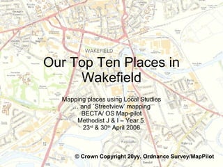
  • 1. Our Top Ten Places in Wakefield Mapping places using Local Studies … and `Streetview’ mapping BECTA/ OS Map-pilot Methodist J & I – Year 5 23 rd & 30 th April 2008 © Crown Copyright 20yy. Ordnance Survey/MapPilot
  • 2.
  • 3. A gallery of photographs was created from the Geograph website The Geograph British Isles project aims to collect geographically representative photographs and information for every square kilometre of Great Britain and Ireland . http://www.geograph.org.uk/ Photographs on Geograph are covered by the Creative Commons Licence. This means that they can be downloaded and used in school projects.
  • 4.
  • 5.
  • 6.
  • 7.
  • 8. One problem that we had was that some of Wakefield’s most important buildings, for example the Cathedral, the Museum and the Town Hall are all sited to the North of this map. Online mapping programmes, for example Google Maps, allow much greater flexibility than the fixed parameter map used here. When selecting the parameters of the map for the children’s use I decided to centre the school approximately in the middle of the map. © Crown Copyright 20yy. Ordnance Survey/MapPilot
  • 9. It was interesting to see which places the children had chosen and to read their comments.
  • 10.  
  • 11.  
  • 12. Two girls chose to take some extra photographs to add to our gallery A number of people in the class chose to use these images. So we need to say a big thank you.
  • 13. Where children chose to locate a photograph sometimes revealed a misunderstanding Actual location The children chose this location. It is easy to see why they made an error because people do moor barges on the Fall Ings Cut. © Crown Copyright 20yy. Ordnance Survey/MapPilot
  • 14.
  • 15.
  • 16.
  • 17.
  • 18.