SlideShare una empresa de Scribd logo
1 de 50
Descargar para leer sin conexión
Utah

Salt Lake City Mill
11 e.(2) Disposal Site

Green River Site

South Clive Disposal
Cell

(Atlas) Moab Mill

(Rio Algom) Lisbon Valley Site

Monticello Mill Site and
Vicinity Properties

(Plateau)
Shootaring Canyon Site

(EFN) White Mesa Site

Mexican Hat Site

Long-Term Stewardship Site Highlights

11 e.(2) Disposal Site (page 3)
Site Size- 14.6 hectares (36.2 acres)
Current Landlord- Envirocare of Utah
Expected Future Landlord- U.S. Department of
Energy
(Atlas) Moab Mill (page 5)
Major Activities- disposal cell monitoring;
groundwater monitoring; access restrictions; erosion
control
Site Size- 162 hectares (400 acres)
Start/End Years- yet to be determined
Estimated Average Annual Cost FY 2005-2006$16,500
(EFN) White Mesa Site (page 9)
Site Size- 202 hectares (500 acres)
Current Landlord -International Uranium Corporation
Expected Future Landlord- U.S. Department of
Energy, Grand Junction Office
Green River Site (page 13)
Major Activities- disposal cell monitoring;
groundwater monitoring; access restrictions;
inspections; maintenance
Site Size- 10 hectares (25 acres)
Start/End Years - engineered unit - 1989/in
perpetuity, groundwater- 2009-2018
Estimated Average Annual Cost FY 2000-2006$88,300

Mexican Hat Site (page 17)
Major Activities - groundwater monitoring; disposal cell
monitoring
Site Size- 48 hectare (119 acre)
Start/End Years - disposal cell1997 - in perpetuity;
groundwater 1999-2004
Estimated Average Annual Cost FY 2000-2006$139,000
Monticello Mill Site and Vicinity Properties (page 23)
Major Activities- disposal cell monitoring; institutional
control enforcement; supplemental standards area
monitoring; groundwater monitoring
Site Size- 2,300 hectares (5, 700 acres)
Start/End Years- 2001/in perpetuity
Estimated Average Annual Cost FY 2000-2006$286,000
(Plateau) Shootaring Canyon Site (page 33)
Total Site Area· unknown
Current Landlord- U.S. Energy Corporation through its
subsidiary, Plateau Resources Limited
Expected Future Landlord· U.S. Department of
Energy, Grand Junction Office

(Rio Algom) Lisbon Valley Site (page 37)
Site Size- 130 hectares (330 acres)
Current Landlord- Rio Algom through its subsidiary,
Rio Algom Mining Corporation
Expected Landlord- U.S. Department of Energy,
Grand Junction Office
Salt Lake City Mill (page 41)
Major Activities- groundwater monitoring; land use
restrictions; record keeping
Site Size Area- 52 hectares (128 acres)
Start-End Years -1989-2004
Estimated Average Annual Cost FY 2000-2006$25,000
South Clive Disposal Cell (page 45)
Major Activities- disposal cell monitoring
Site Size- 40 hectares (99 acres)
Start/End Years -1997/in perpetuity
Estimated Average Annual Cost FY 2000-2006$32,342
Table of Contents

Table of Contents

11e.(2) Disposal Site ..................................................................... 3
(Atlas) Moab Mill ....................................................................... 5
(EFN) White Mesa Site ................................................................... 9
Green River Site ........................................................................ 13
Mexican Hat Site ....................................................................... 17
Monticello Mill Site and Vicinity Properties ................................................. 23
(Plateau) Shootaring Canyon Site .......................................................... 33
(Rio Algom) Lisbon Valley Site ........................................................... 37
Salt Lake City Mill ..................................................................... 41
South Clive Disposal Cell ................................................................ 45

Utah

1
National Defense Authorization Act (NDAA) Long-Term Stewardship Report

Utah

2
lle.(2) Disposal Site

lle.(2) DISPOSAL SITE 1
1.0

SITE SUMMARY

1.1

Site Description and Mission

Envirocare of Utah, which is a commercial low-level
SITE HIGHLIGHTS
waste disposal site, contains within its boundaries a
disposal cell for byproduct material defined under the
Total Site Area- 14.6 hectares (36.2 acres)
Atomic Energy Act, as amended. This disposal cell,
Estimated Volume of Residual Contaminantsknown as the "11e.(2) Disposal Site," is located
900,000 cubic meters (1 million cubic yards)
approximately 137 kilometers (85 miles) west of Salt
Current Landlord- Envirocare of Utah
Expected Future Landlord- U.S. Department of
Lake City and 4 kilometers (2.5 miles) south of U.S.
Energy
Interstate 80 in Tooele County, Utah. The disposal cell
is currently 14.6 hectares (36.2 acres), but could
ultimately be 37.1 hectares (91.7 acres) and hold up to
4.2 million cubic meters (5.5 million cubic yards) of waste.
Envirocare of Utah owns a license to receive, store, and
dispose of 11e.(2) byproduct material onsite. 11e.(2)
byproduct material is defined by law under Section 11e.(2)
of the Atomic Energy Act, as amended by Title II of the
Uranium Mill Tailings Radiation Control Act of 1978, as:
tailings or waste produced by the extraction or
concentration of uranium or thorium from any ore
processed primarily for its source material (i.e., uranium or
thorium) content. A portion of the material disposed at the
lle.(2) Disposal Site originated from the removal of waste
from sites remediated under the Formerly Utilized Sites
Remedial Action Program (FUSRAP).

~

---------- -------·~

0.25

0

k;I-WJi{fr>ads

0.5

Miles

~

•

B

~

!!
Tc S~~~a~~~;~;Y. UT

-+

r--o-

lu

'"

 I'

·····

i
SoulhCii¥e
Dlspn9a1Call

To date, approximately 900,000 cubic meters (one million
cubic yards) of material have been disposed in the cell. The
active portion of the cell occupies 10 hectares (24.9 acres)
and a cap has been placed over 4.6 hectares (11.3 acres).
The disposal cell lies in a flat ancient lake bed along the
eastern edge of the Great Salt Lake Desert, which extends
approximately 80 kilometers (50 miles) from the
Nevada/Utah border. The surrounding area is sparsely

'------::

11e.(2)

Disposal She

EnvirocareofU!ah

lle.(2) Disposal Site

1

This report is developed in response to a Congressional request in the Fiscal Year (FY) 2000 National
Defense Authorization Act (NDAA). As requested by the Act, this report addresses current and anticipated longterm stewardship activities at each site or portion of a site by the end of calendar year 2006 ("Conference Report on
S.l059, National Defense Authorization Act for Fiscal Year 2000," Congressional Record, August 5, 1999).
Based on current planning, the lle.(2) Disposal Site is not expected to require long-term stewardship until after
2006, and for this reason the site is not the primary focus of this report. This brief summary of the site cleanup
activities is provided for background information and potential future long-term stewardship activities. (See Section
3.2 of Volume I).
Utah

3
National Defense Authorization Act (NDAA) Long-Term Stewardship Report

populated, with the nearest residences at least 48 kilometers (30 miles) from the site. Roads in the area are used
for recreation and for access to military firing ranges south of the site. Vegetation in the area is sparse, and the
semi-arid low shrub land is used primarily for grazing.

For additional information about the lle.(2) Disposal Site, please contact:
Envirocare of Utah, Inc.
Suite 116
46 W. Broadway
Salt Lake City, UT 84101-2019
Phone: 801-532-1330

Utah

4
(Atlas) Moab Mill

(ATLAS) MOAB MILL

1.0

SITE SUMMARY

1.1

Site Description and Mission

The (Atlas) Moab Mill is the location of a former
uranium milling site that operated from 1956 until1988.
The site is located on 162 hectares (400 acres) of land
on the northwest shore of the Colorado River in Grand
County, Utah, approximately 5 kilometers (3 miles)
from the city of Moab. Adjacent to the mill on the
north and west are U.S. Highway 191 and Utah
Highway 279, respectively. Arches National Park is
north of the site across U.S. Highway 191. The Rio
Grande Railroad traverses a small section of the
property, just west of Highway 279. Milling operations
at the site created uranium mill tailings and other
process-related wastes, which occupy approximately 53
hectares (130 acres) of the site and are located about
230 meters (750 feet) from the Colorado River.

LONG-TERM STEWARDSHIP HIGHLIGHTS
Major Long-Term Stewardship Activities -yet to be

determined
Total Site Area- 162 hectares (400 acres)
Estimated Volume of Residual Contaminants-

groundwater unknown; surface water unknown; soil
unknown
Long-Term Stewardship Start-End Years- yet to be
determined*
Average Annual Long-Term Stewardship Cost FY
2005-2006- $16,500
Landlord- U.S. Department of Energy, Grand

Junction Office
*The long-term stewardship start and end years will depend
on the remedial action selected and completion date. Longterm stewardship activities are not expected to begin until
after 2006.

The current mission of the (Atlas) Moab Mill site has
been modified by the National Defense Authorization
Act (NDAA) for Fiscal Year (FY) 2001. The U.S.
Department of Energy (DOE) will be responsible for conducting long-term stewardship activities at the site, if
any are necessary.
In the NDAA forFY 2001, the (Atlas) Moab Mill site'sremediation schedule and plans were changed. To satisfy

the site's remediation procedures in the NDAA for FY 2001, DOE must prepare a remediation plan for the site,
in accordance with Title I of the Uranium Mill Tailings Radiation Control Act of 1978 (UMTRCA), that includes
considering the relocation of the mill tailings and contaminated media to an offsite disposal cell (most likely a
disposal cell constructed specifically to contain the remediated materials from the (Atlas) Moab Mill site) and
restoration of the groundwater. As part of the development of this remediation plan, DOE must cooperate with
the National Academy of Sciences and thoughtfully consider its recommendations on various remedial
alternatives. Also, DOE will develop, in consultation with the Trustee, NRC, and the State of Utah, an efficient
and legal means for transferring all responsibilities and title of the (Atlas) Moab Mill site, and all the materials
therein, from the Trustee to DOE. This remediation plan must be completed no later than one year after the date
of the enactment of the NDAA for FY 2001; and DOE must begin remedial action at the site as soon as
practicable after the completion of the plan.
The license for the materials at the (Atlas) Moab Mill site, issued by NRC, will terminate one year after the date
ofthe enactment of the NDAA for FY 2001, unless DOE determines that the license can be terminated earlier.
Until the license is terminated, the Trustee, subject to the availability of funds appropriated specifically for the
site's remediation or the funds made available by the Trustee from the site's trust, may carry out (1) interim
measures to reduce or eliminate the localized high ammonia concentrations in the Colorado River; (2) activities
to dewater the mill tailings at the site; and (3) other activities related to the site, subject to the authority of the
NRC and in consultation with DOE.
The historical mission of the uranium milling site was to process uranium for sale to the U.S. Government and
Utah

5
National Defense Authorization Act (NDAA) Long-Term Stewardship Report

other industries. More than half of the uranium
produced at the site was used to support the
U.S. Government national defense program.
The Uranium Reduction Company (URC) built
the (Atlas) Moab Mill and began operations in
October 1956. Atlas Corporation purchased the
site from URC in 1962 and operated the mill
until 1984. The majority of the ore processed
at the (Atlas) Moab Mill was transported to the
mill from the Big Indian Uranium District,
approximately 48 kilometers (30 miles) to the
southeast. The ore was ground to a sufficiently
fine consistency to allow efficient chemical
reactions to occur, and was then processed,
using either the acid-leach or alkaline-leach
process. After milling, the combined waste
slurry from both processes was pumped into the
tailings impoundment.
1.2

(MosfMoap~ill,
···.-,~
e!Moab
To G~~

5J~~~~~- co Jf

-~~~;;;a;---;;-~;;;,co
(-240miles)


.
.

'1-.

(Rio AJgom) Lispon Valley Site

•.

Site Cleanup and Accomplishments

20
10
0
Contamination at the (Atlas) Moab Mill
Miles
resulted from the previous uranium milling
operations conducted by URC and Atlas
(Atlas) Moab Mill
Corporation. Approximately 10,500,000 tons
of uranium mill tailings are currently located on
the site. In addition to the tailings, soil and
building debris are contaminated with uranium, radium, and thorium.
In 1988, the Atlas Corporation began decommissioning the site and constructing an interim cover for the tailings
disposal area. The former mill was decommissioned and the wastes were consolidated under an interim cover
that was completed in 1995. In 1998, the Atlas Corporation declared bankruptcy. As a result ofthe bankruptcy
proceedings, the Moab Uranium Mill Site Transfer Agreement was established, which provided for the transfer
of the site's NRC license to a trustee that was to be responsible for completing the site's remediation. In January
2000, PricewaterhouseCoopers was selected as the trustee and agreed to oversee and ensure that remediation of
the (Atlas) Moab Mill was completed in accordance with the conditions of the NRC license and the site's transfer
agreement. However, as stated above, the Trustee will relinquish all responsibility to DOE within one year of
enactment of the NDAA for FY 2001.
Groundwater at the site is contaminated with radioactive materials, including radium and uranium, and nitrogen
compounds from the uranium ore processing. The Colorado River is contaminated with localized, high
concentrations of ammonia. The initial monitoring program of water resources at and around the site began in
1976, after approximately 20 years of mill operation. The monitoring program was designed to collect surface
water samples from the Colorado River and groundwater samples from the alluvial aquifer situated beneath the
tailings impoundment. NRC has indicated that remediating contaminated groundwater will require a substantially
longer period of time than will be involved in the surface reclamation of the mill tailings.

Utah

6
(Atlas) Moab Mill

2.0

SITE-WIDE LONG-TERM STEWARDSHIP

2.1

Long-Term Stewardship Activities

The DOE Grand Junction Office will be responsible for performing long-term stewardship activities at the (Atlas)
Moab Mill site, if any are required. The types of long-term stewardship activities that may be needed at the site
will not be known until the site's remediation plan is prepared and the remedial action is completed. DOE
provides a 24-hour phone line for reporting site concerns.
Site records will be kept in permanent storage at the DOE Grand Junction Office in Colorado. The types of
records that will be maintained include site characterization data, remedial action design information, the
radiological assessment, long-term monitoring plans, annual inspection reports, and current and historic
monitoring data.

2.2

Specific Long-Term Stewardship Activities
STAKEHOWER INVOLVEMENT

Groundwater
The groundwater is expected to require annual
monitoring. The specific monitoring requirements will
be prescribed in the site's long-term surveillance plan
that will be developed after remediation is completed,
and if long-term stewardship activities are required.

Surface Water/Sediments

DOE will assume the lead role in stakeholder
involvement during remedial action as a result of the
NDAA for FY 2001. Once remediation is complete,
the annual inspection reports for the (Atlas) Moab Mill
will be distributed to the local libraries and to any
stakeholders requesting them. The reports, once
published, will be available on the DOE Grand
Junction Office website at www.doegjpo.com.

The surface water may require periodic monitoring if it is not completely cleaned up during the site's remedial
action. The specific monitoring requirements will be prescribed in the site's long-term surveillance plan that will
be developed after remediation is completed, and if long-term stewardship activities are required.

2.3

Regulatory Regime

The long-term stewardship activities, if required, at the (Atlas) Moab Mill will be governed by several
requirements in the following regulations: Title I ofUMTRCA; the Atomic Energy Act; EPA standards, including
Title 40 of the Code of Federal Regulations, Part 192 Subparts B and C; and the National Environmental Policy
Act, as amended.

2.4

Assumptions and Uncertainties

The site's remediation strategy has not yet been selected. DOE assumes that the tailings will be removed to an
offsite disposal cell. The costs for conducting long-term stewardship activities at an offsite disposal cell will be
similar to other UMTRCA Title II, offsite disposal cells.
The (Atlas) Moab Mill site will undergo groundwater restoration activities for a currently undetermined length
of time; after which, the site is expected to be eligible for unrestricted use.

3.0

ESTIMATED LONG-TERM STEWARDSHIP COSTS

The cost estimates, identified in the table below, are based on the actual costs of long-term stewardship activities
at other similar sites under DOE's management. Actual costs will vary depending upon the groundwater
Utah

7
National Defense Authorization Act (NDAA) Long-Term Stewardship Report

sampling frequency, number of analyses sampled, and the number of sampling points (e.g., wells). Contingency
costs, such as cap replacement, have not been incorporated in the cost estimates.
Site Long-Term Stewardship Costs (Constant Year 2000 Dollars)
Year(s)

Amount

Year(s)

Amount

Year(s)

Amount

FY2000

$0

FY2008

$16,500

FY 2036-2040

$81,800

FY 2001

$0

FY 2009

$16,500

FY 2041-2045

$81,800

FY 2002

$0

FY2010

$16,500

FY 2046-2050

$81,800

FY 2003

$0

FY 2011-2015

$78,500

FY 2051-2055

$81,800

FY 2004

$0

FY 2016-2020

$76,400

FY 2056-2060

$81,800

FY 2005

$16,500

FY 2021-2025

$76,600

FY 2061-2065

$81,800

FY 2006

$16,500

FY 2026-2030

$81,000

FY 2066-2070

$81,800

FY 2007

$16,500

FY 2031-2035

$81,800

4.0

FUTURE

USES

Assuming that the contaminated materials are relocated to an offsite disposal cell, title to the (Atlas) Moab Mill
site will likely be transferred or sold after remediation activities at the site are completed. The future use of the
site will depend on the remedial action that is selected in the site's remediation plan, but DOE anticipates that
the site will ultimately be remediated to unrestricted use.
The associated, anticipated disposal cell will be a permanent mill tailings repository under DOE ownership with
the necessary use restrictions.

For more information about the (Atlas) Moab Mill site, please contact:
Art Kleinrath, Long-Term Surveillance and Maintenance Program Manager
U.S. Department of Energy, Grand Junction Office
2597 B3/4 Road, Grand Junction, CO 81503
Phone: 970-248-6037
or visit the Internet website at http://www.doegjpo.com

Utah

8
(EFN) White Mesa Site

(EFN) WHITE MESA SITE 1
1.0

SITE SUMMARY

1.1

Site Description and Mission

The (EFN) White Mesa Site is the location of a
currently operating uranium milling site. The site is
located in San Juan County, Utah, approximately eight
kilometers (five miles) south of Blanding. The (EFN)
White Mesa site is currently owned and operated by the
International Uranium Corporation (formerly owned
and operated by Energy Fuels Nuclear, Inc). The site
covers approximately 202 hectares (500 acres).

LONG-TERM STEWARDSHIP HIGHLIGHTS
Total Site Area- 202 hectares (500 acres)
Current Landlord- International Uranium Corporation
Expected Future Landlord- U.S. Department of
Energy, Grand Junction Office
Reason Not Subject to NDAA Requirements - This site
is an UMTRCA Title II site that will not be transferred
to DOE until 2025

Once the site is transferred to DOE in 2025, the only
site mission will be the long-term surveillance and
maintenance of the disposal cell. The exact number of acres that will be transferred to DOE has not yet been
determined.
The current and historic mission of the site is to extract uranium oxide concentrate (commonly called yellowcake)
from uranium ores found in the region. The (EFN) White Mesa Site uranium milling site was constructed in the
late 1970s by Energy Fuels Nuclear, Inc. to process uranium ores from the Colorado Plateau. After two- and-ahalf years of operation, the mill was shut down. In May 1997, International Uranium Corporation, the current
owner and site operator, purchased the mill assets. The mill operated intermittently throughout the 1980s and
1990s and is currently in operation. From its inception through April 1999, the mill processed a total of 3.8
million tons of uranium ore.

1.2

Site Cleanup and Accomplishments

The International Uranium Corporation will be responsible for conducting all remediation activities at the (EFN)
White Mesa site. All contamination at the site will be remediated and disposed of in two onsite disposal cells.
Materials and debris associated with the decommissioning of the mill facility will be placed in one of the lined
disposal cells. Contaminated soils, crystals, and the synthetic liner from an existing evaporation pond will be
consolidated in the other cell, along with offsite soils contaminated by wind-blown mill tailings. When
remediation activities are completed, the site will have two disposal cells containing approximately two million
cubic meters (2.6 million cubic yards) of uranium mill tailings. The precise size of the disposal cells will not be
known until remediation is completed. Once the cells reach capacity, they will be capped with a one-meter
(three-foot) layer of soil, followed by a layer of compacted clay and eight-to-20 centimeters (three-to-eight
inches) of rock riprap for erosion control. The cells will be designed to limit the infiltration of precipitation,

1

This report is developed in response to a Congressional request in the Fiscal Year (FY) 2000 National
Defense Authorization Act (NDAA). As requested by the Act, this report addresses current and anticipated longterm stewardship activities at each site or portion of a site by the end of calendar year 2006 ("Conference Report on
S.l059, National Defense Authorization Act for Fiscal Year 2000," Congressional Record, August 5, 1999).
Based on current planning, the (EFN) White Mesa Site is not expected to be transferred to the U.S. Department of
Energy (DOE) for long-term stewardship until 2025, and for this reason the site is not the primary focus of this
report. This brief summary of the site cleanup activities is provided for background information and potential future
long-term stewardship activities. (See Section 3.2 of Volume I).
Utah

9
National Defense Authorization Act (NDAA) Long-Term Stewardship Report

prevent erosion, and control radon gas releases.
No groundwater contamination has been detected by the site's existing groundwater detection monitoring
program. Because contamination has not been detected, the U.S. Nuclear Regulatory Commission (NRC)
Reclamation Plan for the (EFN) White Mesa Site does not require any corrective measures for groundwater.

J
Wayne County

ToSol!LokeCoy,UT
(•180mUes)

/

.

(Plateau) Shootaring Canyon Site

""

)(

'

-~~~~7~--~~-----~
.
/(-....

,~


)../

/

.---------------~--~}

0

15

30

Miles

(EFN) White Mesa Site

2.0

EXPECTED FUTURE USES AND SITE RESPONSIBILITY

Once the (EFN) White Mesa Site is transferred to DOE in 2025, the DOE Grand Junction Office will be
responsible for long-term stewardship activities. The two disposal cells at the site will be similar to other
uranium mill tailings disposal cells and will have similar long-term stewardship activities.
Anticipated site-wide long-term stewardship activities include restricting access by fencing and posting warning
signs along the site boundary. DOE will repair the fence and replace the signs, as necessary. DOE will staff a
24-hour phone line for reporting site concerns. Drilling and other intrusive activities will be prevented within
site boundaries through institutional controls. DOE expects to conduct annual surface inspections to ensure the
integrity of the disposal cell covers and other engineered features. Groundwater is likely to be monitored
annually as a "best management" practice.
Site records will be placed in permanent storage at the DOE Grand Junction Office in Colorado. The types of
records maintained include site characterization data, remedial action design information, the site completion
report, long-term monitoring plans, annual inspection reports, and current and historic monitoring data.

Utah

10
(EFN) White Mesa Site

For additional information about the (EFN) White Mesa Site, please contact:
Art Kleinrath, Long-Term Surveillance and
Maintenance Program Manager
U.S. Department of Energy, Grand Junction Office
2597 B3/4 Road
Grand Junction, CO 81503
Phone:970-248-6037
or visit the Internet website at http://www.doegjpo.com

Utah

Bill Von Till, Project Manager
Uranium Recovery and Low-Level Waste
Branch
U.S. Nuclear Regulatory Commission
Mail Stop 7J8
Washington, DC 20555-001
Phone: 301-415-6351
or visit the Internet website at http://www.nrc.gov

11
National Defense Authorization Act (NDAA) Long-Term Stewardship Report

Utah

12
Green River Site

GREEN RIVER SITE
1.0

SITE SUMMARY

1.1

Site Description and Mission

The Green River Site is the location of a former
uranium milling site that operated between 1958 and
1961. The site covers approximately 10 hectares (25
acres) and is located in Grand County in the east-central
portion of Utah. The site is 1.6 kilometers (one mile)
southeast of the City of Green River and 113 kilometers
(70 miles) west of the Utah-Colorado border. The U.S.
Army's White Sands Missile Range, Utah Launch
Complex, uses most of the vacant land south and east of
the site. Agriculture is the predominant land use in this
sparsely populated area.

LONG-TERM STEWARDSHIP HIGHLIGHTS
Major Long-Term Stewardship Activities- disposal

cell monitoring; groundwater monitoring; access
restrictions; inspections; maintenance
Total Site Area- 10 hectares (25 acres)
Estimated Volume of Residual Contaminants-

engineered unit 292,200 cubic meters (382,000 cubic
yards); groundwater 685,200 cubic meters (181 million
gallons)
Long-Term Stewardship Start-End Years- engineered
unit- 1998-in perpetuity; groundwater- 2009-2018

Average Annual Long-Term Stewardship Cost FY
The milling operations used to process the uranium ore
2000-2006- $88,300
created approximately 292,200 cubic meters (382,000
Landlord- U.S. Department of Energy, Grand
cubic yards) of process-related waste and uranium mill
Junction Office
tailings. The tailings were originally deposited onsite
in a two-meter (seven-foot) thick pile covering four
hectares (nine acres). The U.S. Department of Energy
(DOE) encapsulated the tailings in an engineered disposal cell in 1989.

The current mission of the Green River Site is monitoring and maintaining the onsite disposal cell. The site is
subject to Title I of the Uranium Mill Tailings Radiation Control Act of 1978 (UMTRCA). As such, DOE is
responsible for remediation and long-term stewardship activities of the site. DOE began long-term stewardship
activities for the engineered unit in 1998.
The historic mission of the Green River site was to provide uranium for the U.S. Government's national defense
program. Union Carbide built the uranium processing mill in 1958 and operated it until1961. Later, the mill
buildings were used for assembly of missile components for the Utah Launch Complex. The State of Utah
acquired ownership of the mill and tailings site in 1988.

1.2

Site Cleanup and Accomplishments

Remediation of the site involved consolidating and stabilizing the residual radioactive material in a disposal cell
at the former processing site and remediating 17 vicinity properties. The State of Utah and the U.S. Nuclear
Regulatory Commission (NRC) concurred in DOE's decision to consolidate the tailings onsite in an engineered
disposal cell.
Radioactive materials from the original pile, the demolished or decontaminated mill buildings, and contaminated
vicinity properties were consolidated into a U.S. Environmental Protection Agency (EPA)-compliant disposal
cell. The cell was excavated to bedrock and lined with two meters (six feet) of low-permeability soil. The cell
measures 137 meters (449 feet) by 162 meters (532 feet) at the base and rises 13 meters (43 feet) above the
surrounding land. Most of the contaminated materials are below grade. Approximately 292,200 cubic meters
(382,000 cubic yards) of contaminated materials, including uranium, radium, and thorium, were placed in the
2.5-hectare (six-acre) cell (equivalent to 501,000 dry tons of contaminated material with an estimated activity
Utah

13
National Defense Authorization Act (NDAA) Long-Tenn Stewardship Report

of 30 curies of radium-226). A clay-rich soil layer placed over the contaminated materials extends to the edge
of the cell below grade and serves as a low permeability radon barrier. Above grade, the radon barrier is covered
by a layer of rock placed on granular bedding material. The cell design promotes rapid precipitation runoff to
minimize leachate. Surface remedial action was completed in September 1989.

@

Groundwater Monitoring Well

~ GroundwaterContaminanon

0

0.1

To Grand Junction, CO
(·B5miles)

..

Green River Site

Approximately 685,200 cubic meters (181 million gallons) of groundwater in the vicinity of the Green River Site
are contaminated with materials generated during uranium ores processing. Uranium processing-related
contaminants have been identified in the alluvium and in the upper Cedar Mountain Formation beneath the site.
An upward hydraulic gradient prevents these contaminants from migrating into lower strata. Groundwater in
these aquifers is not suitable for agricultural or domestic use because of naturally occurring contamination and
low water yields. The groundwater is not a current or potential source of drinking water, as defined in Title 40
of the Code of Federal Regulations, Part 192. Therefore, no active groundwater remediation is planned. DOE
is currently monitoring groundwater to provide additional characterization and to develop a groundwater
compliance strategy for regulatory approval.

2.0

SITE· WIDE LONG-TERM STEWARDSHIP

2.1

Long-Term Stewardship Activities

The DOE Grand Junction Office manages the site
according to a long-term surveillance plan prepared
specifically for the Green River Site. Under provisions
of the plan, the Grand Junction Office conducts annual
Utah

STAKEHOLDER INVOLVEMENT
Community interaction has been minimal since the
surface remedial action was completed. Copies of the
annual inspection report for Green River Site and other
sites are distributed to the local library and to any
stakeholders requesting them. The annual inspection
reports are also published on the DOE Grand Junction
Office website at www.doegjpo.com ..
14
Green River Site

inspections of the site to evaluate the condition of surface features. DOE also performs site maintenance, such
as fence repair and sign replacements, as necessary. A locked security fence surrounds the perimeter of the cell
to control access.
The disposal site is owned by the Federal Government, which controls land use within the site boundaries. DOE
performs long-term stewardship activities, as required under the NRC general license (10 CPR 40.27), to
maintain protectiveness of the remedy and to ensure compliance with the applicable regulations. A chain- link
fence with locked gates restricts access to the disposal cell, and warning signs are posted every 152 meters (500
feet) along the site boundary. DOE staffs a 24-hour phone line for reporting site concerns. Drilling and other
intrusive activities are prevented within site boundaries through the use of institutional controls.
DOE maintains and updates specific records and reports required to document the long-term stewardship
activities at the Green River Site. DOE submits an annual report to NRC that documents the results of the longterm surveillance plan, as required by NRC regulations in Title 10 of the Code of Federal Regulations Part 27,
Appendix A, Criterion 12. Site records are kept in permanent storage at the DOE Grand Junction Office in
Colorado and are available for review by the public. The types of records maintained include site
characterization data, remedial action design information, the site completion report, long-term monitoring plans,
annual inspection reports, and current and historic monitoring data. Real property records are maintained at the
DOE Albuquerque Operations Office in New Mexico.

2.2

Specific Long-Term Stewardship Activities

Engineered units
Long-term stewardship activities for the disposal cell include conducting annual inspections to assess the
integrity of the cell cover and other engineered features, and ensuring effectiveness of institutional controls. No
significant repairs are anticipated for the disposal cell. The Green River Site disposal cell is designed and
constructed to last for 200 to 1,000 years. However, DOE's responsibility for the safety and integrity of the
Green River Site will continue in perpetuity. Under the provisions of the long-term stewardship plan, DOE will
monitor groundwater on a quarterly basis through at least 2001 to demonstrate the effectiveness of the cell in
isolating the encapsulated wastes from the groundwater. After 2001, the groundwater monitoring strategy will
be reevaluated. It is expected to continue beyond 2001, but at a reduced frequency.

Groundwater
No groundwater remediation occurred at the Green River Site because of the already high levels of naturally
occurring constituents in the groundwater. DOE is currently developing a groundwater compliance strategy for
regulatory approval. The monitoring frequency and duration will be determined by the compliance strategy.
Current planning assumes that DOE will monitor the groundwater once every five years until2018.

2.3

Regulatory Regime

In 1998, the Green River Site came under a general license issued by NRC for custody and long-term care of
residual radioactive disposal sites (contained in Title 10 of the Code ofFederal Regulations, Section 40.27). The
purpose of the general license is to ensure that such sites will be cared for in a manner that protects human health
and safety and the environment. The general license went into effect when NRC agreed that the site conformed
to cleanup standards and formally accepted the site's long-term surveillance plan.
Long-term stewardship activities at the Green River Site are governed by several requirements in the following
regulations: UMTRCA; the Atomic Energy Act of 1954, as amended; EPA Groundwater Protection Standards,
Utah

15
National Defense Authorization Act (NOAA) Long-Term Stewardship Report

including Subparts A, B, and C of Title 40 of the Code of Federal Regulations Part 192; and the National
Environmental Policy Act of 1969, as amended.

2.4

Assumptions and Uncertainties

Because long-term stewardship activities have been conducted since 1998, the long-term stewardship activities
at the site are well known and are not expected to change dramatically.
DOE expects that the disposal cap will not need to be replaced for a minimum of 200 years. Groundwater and
disposal cell monitoring will occur in perpetuity.

3.0

ESTIMATED LONG-TERM STEWARDSHIP COSTS

Long-term stewardship costs for the Green River Site are based on historical costs incurred while conducting
actual surveillance and maintenance activities. Costs for fiscal years (FY) 2001 through 2006 include prorated
costs associated with decommissioning unnecessary monitoring wells at similar sites. Contingency costs, such
as cap replacement, have not been incorporated in the cost estimates.
Site Long-Term Stewardship Costs (Constant Year 2000 Dollars)
Year(s)

Amount

Year(s)

Amount

Year(s)

Amount

FY 2000

$41,000

FY 2008

$29,000

FY 2036-2040

$142,400

FY 2001

$105,200

FY 2009

$29,000

FY 2041-2045

$142,200

FY2002

$111,400

FY 2010

$29,000

FY 2046-2050

$142,400

FY 2003

$99,400

FY 2011-2015

$129,700

FY 2051-2055

$142,200

FY 2004

$112,200

FY 2016-2020

$129,600

FY 2056-2060

$142,400

FY 2005

$73,900

FY 2021-2025

$132,800

FY 2061-2065

$142,200

FY 2006

$75,100

FY 2026-2030

$141,000

FY 2066-2070

$142,400

FY 2007

$29,200

FY 2031-2035

$142,200

4.0

FUTURE USES

The future use of the site will be restricted to long-term monitoring and maintenance of the disposal cell in
perpetuity.

For more information about the Green River Site, please contact:

Art K1einrath, Long-Term Surveillance and Maintenance Program Manager
U.S. Department of Energy, Grand Junction Office
2597 B3/4 Road, Grand Junction, CO 81503
Phone: 970-248-6037
or visit the Internet website at http://www.doegjpo.com

Utah

16
Mexican Hat Site

MEXICAN HAT SITE
1.0

SITE SUMMARY

1.1

Site Description and Mission

The Mexican Hat Site is the location of a former
uranium processing mill that operated from 1957 until
1965, and a sulfuric acid plant that operated from 1957
to 1970. The site also contains a disposal cell for the
uranium mill tailings and other process-related wastes
from the former mill at the site and from the Monument
Valley Site in Arizona). The Mexican Hat Site is
located on Navajo Nation land in San Juan County,
Utah, east of U.S. Highway 163. The 48-hectare (119acre) site lies between the towns of Halchita and
Mexican Hat, approximately 13 kilometers (18 miles)
southwest of Bluff, Utah, and 16 kilometers (10 miles)
north of the Arizona border.

LONG-TERM STEWARDSHIP HIGHLIGHTS
Major Long-Term Stewardship Activities groundwater monitoring; disposal cell monitoring
Total Site Area- 48 hectares (119 acres)
Estimated Volume of Residual Contaminants- disposal
cell2.66 million cubic meters (3.48 million cubic
yards); groundwater 416,400 cubic meters (544,600
cubic yards)
Long-Term Stewardship Start-End Years- disposal
cell1997-in perpetuity; groundwater 1999-2004
Average Annual Long-Term Stewardship Cost FY
2000-2006-$139,000

Landlord- U.S. Department of Energy, Grand
Junction Office; Navajo Nation

Contamination of the site resulted from previous
uranium milling and acid production operations. The
milling operations created process-related wastes and tailings. Before remedial action was completed, the site
consisted of two tailings piles totaling 29 hectares (72 acres). One covered 10 hectares (25 acres) and the other
covered 19 hectares (47 acres). The site also contained seven mill buildings and associated debris, a concrete
pad, contaminated soil, and wind-blown material. An estimated 2.2 million cubic meters (2.8 million cubic
yards) of contaminated material were contained in these two tailings piles and on an additional! 01 hectares (250
acres) of adjacent land. The contaminated material at this site and contaminated material from the Monument
Valley Site was stabilized in a 29-hectare (72-acre) disposal cell at the Mexican Hat Site. The U.S. Department
of Energy (DOE) closed the cell and completed surface remediation of the site in January 1995.
The current mission of the Mexican Hat Site is to perform long-term stewardship activities, including disposal
cell monitoring and the groundwater monitoring at the former mill site. The site is subject to Title I of the
Uranium Mill Tailings Radiation Control Act of 1978 (UMTRCA). As such, DOE is responsible for any
remediation and long-term stewardship activities. DOE began conducting long-term stewardship activities at the
site in 1997.
The historic mission of the Mexican Hat Site was to process uranium for sale to the U.S. Government. The mill
at the site was constructed and operated from 1957 to 1963 by Texas-Zinc Minerals Corporation. The Atlas
Corporation purchased the mill in 1963 and operated it until it was closed in 1965. When the Atlas lease expired
in 1970, control of the site reverted to the Navajo Nation. Much of the ore processed at the Mexican Hat Site
came from the White Canyon area of Utah and contained a considerable amount of copper sulfide and other
sulfide minerals. During its operation, the uranium mill processed 2.2 million tons of ore and produced 5,700
tons of uranium concentrate.
At the time of the remedial action, the concrete pad for the mill building and several associated buildings and
structures (e.g., scale house, office building, and tanks) were left in place. One or two of the smaller buildings
appeared to be used for storage, and the Navajo Tribal Utility Authority operated a small electrical substation
and sewage system (three lagoons) at the site. Access to the site was not restricted; however, the Navajo
Environmental Protection Administration has discouraged any activity at the site since 1978.
Utah

17
National Defense Authorization Act (NDAA) Long-Term Stcwardshi)l Report

~ Groundwater Contamination

0.25

0.5

Miles

To Salt Lake City, UT
(-275 miles)

El<tent of Contamination

Unknown

Monument Valley Site
(-12 miles)

~

Mexican Hat Site

The Mexican Hat Site is also the repository for residual radioactive material from the Monument Valley Site and
eleven vicinity properties. The Monument Valley Site's residual radioactive material was transported to the
Mexican Hat Site and was placed on top of the residual radioactive material in the disposal cell.

1.2

Site Cleanup and Accomplishments

The source of contamination at the Mexican Hat Site was the residual tailings that remained after the milling
process extracted the uranium. DOE completed surface remedial actions in 1995 under the provisions of the
Uranium Mill Tailings Radiation Control Act of 1978 (UMTRCA), in accordance with a remedial action plan
approved by the U.S. Nuclear Regulatory Agency (NRC). Remedial action involved consolidation of
approximately 2 million cubic meters (2.66 million cubic yards) of residual radioactive material in place at the
bottom of what is now the Mexican Hat disposal cell, followed by placement of approximately 703,200 cubic
meters (925,200 cubic yards) of residual radioactive material from the Monument Valley Site, for a total of
approximately 2.66 million cubic meters (3.48 million cubic yards) of residual radioactive material. Eleven
vicinity properties were also remediated concurrent with site remediation activities.
The final disposal cell covers approximately 29 hectares (72 acres). The disposal cell includes a radon cover and
rock surface layer to control erosion. In accordance with U.S. Environmental Protection Agency (EPA)
standards, the disposal cell was designed to remain effective for 200 to 1,000 years.
Groundwater contamination at the Mexican Hat Site was caused by the discharge of waste water and tailings
from uranium milling. Seepage of construction water resulting from consolidation during material compaction
may have contributed to the contamination. Approximately 416,400 cubic meters (544,600 cubic yards) of
Utah

18
Mexican Hat Site

groundwater are contaminated with nitrate, molybdenum, selenium, uranium, net gross alpha, arsenic, chromium,
and radium. Contamination is present in the residual process water within the upper part of the Halgaito
Formation. The former uranium mill was the largest source of contamination. The sulfuric acid plant probably
contributed little additional contamination when compared to the uranium mill. The approved groundwater
compliance strategy for the Mexican Hat Site is to perform no remediation and to continue monitoring the seeps
below the disposal cell. Site data indicate that groundwater in the uppermost aquifer (the lower unit of the
Halgaito Formation) beneath the site is not suitable for use because of the presence of hydrogen sulfide and
hydrocarbons. Contamination introduced from uranium processing is present in the perched, ephemeral
groundwater system at a higher stratigraphic level in the Halgaito Formation. Based upon data from intermittent
seeps downgradient of the disposal cell, it appears that flow rates may be decreasing, and may cease over time.
Monitoring of contaminant concentrations in the seeps will continue as long as water is present.

2.0

SITE-WIDE LONG-TERM STEWARDSHIP

2.1

Long-Term Stewardship Activities

The DOE Grand Junction Office is responsible for performing long-term stewardship activities at the Mexican
Hat Site, including maintaining access restrictions and enforcing institutional controls. DOE will also conduct
annual inspections of the site to evaluate the condition of surface features, perform site maintenance, as
necessary, and monitor the groundwater in the seeps. The seeps will be monitored below the disposal cell for
flow rate and contaminant levels to demonstrate the effectiveness of the cell in isolating the encapsulated wastes
from the local groundwater system until 2004. No drilling or other intrusive activities are allowed within the
property.
The site records for the Mexican Hat Site are kept in permanent storage at DOE's Grand Junction Office
Colorado. The types of records kept include the characterization data, remedial action design, completion report,
long-term monitoring plan, annual inspection reports, and monitoring data.

2.2

Specific Long-Term Stewardship Activities

Engineered Units
The disposal cell contains 4,400,000 dry tons of
STAKEHOLDER INVOLVEMENT
contaminated material, with a total activity of 1,800
curies of radium-226. The disposal cell measures 394
Frequent meeting with representatives of the Navajo
meters by 591 meters (1,200 feet by 1,800 feet) at the
Nation have been held during remediation and since.
Tribal members frequently participate in sampling
base and occupies an area of 29 hectares (72 acres) on
events and annual inspections. Copies of the annual
the 49-hectare (119-acre) site. It abuts a rock outcrop
inspection report for this site are distributed to the
on the south and rises 16 meters (50 feet) above the
local library and any stakeholders that request copies.
surrounding land on the other sides. A posted wire
The report is also published on the GJO website at
fence surrounds the cell. A low-permeability radon
www.doegjpo.com.
barrier, consisting of clayey soil, covers the
contaminated materials to prevent precipitation from
percolating into the underlying tailings and to reduce
radon emissions. The radon barrier is covered by granular bedding material and a layer of rock (riprap) on the
top, the side slopes, and the aprons. The cell design promotes rapid runoff of precipitation to minimize leachate.
Runoff water flows down the slide slopes into the surrounding rock apron. The site location and design were
selected to minimize the potential for erosion from onsite runoff or storm water flow. All surrounding remediated
areas were regraded and reseeded with native species. Existing gullies in the vicinity of the cell were turned into
trenches by excavating the gullies down to the underlying bedrock. Riprap-protected diversion ditches were
Utah

19
National Defense Authorization Act (NDAA) Long-Term StewardshiJl Report

installed to channel runoff water away from the cell. The rock cover on the top and side slopes of the disposal
cell also prevents erosion. The stock fence prevents unauthorized access to the property. The disposal cell is
designed to last for 200 to 1,000 years. However, DOE's responsibility for the safety and integrity of the
Mexican Hat Site will last indefinitely. DOE has a permanent agreement with the Navajo Nation for access to
the site.
Groundwater

Monitoring of springs and seeps will be conducted from 1999 to 2004.
2.3

Regulatory Regime

In 1997, the Mexican Hat Site came under a general license issued by NRC for custody and long-term care of

residual radioactive disposal sites (contained at Title 10 of the Code ofFederal Regulations, Section 40.27). The
purpose of the general license is to ensure that such sites will be cared for in a manner that protects human health
and safety and the environment. The general license went into effect when NRC concurred that the site
conformed to cleanup standards and formally accepted the site-specific long-term surveillance plan.
Long-term stewardship activities of the Mexican Hat Site are governed by several requirements in the following
regulations: UMTRCA; the Atomic Energy Act of 1954, as amended; EPA Groundwater Protection Standards,
including Subparts A, B, and C of Title 40 of the Code ofFederal Regulations Part 192; a cooperative agreement
between DOE and the State of Utah; a cooperative agreement between DOE and the Navajo Nation; and the
National Environmental Policy Act of 1969, as amended.
2.4

Assumptions

and Uncertainties

DOE assumes that groundwater compliance monitoring will be required in perpetuity. DOE assumes that the
site is institutionally and physically stable. Because DOE is already conducting long-term stewardship activities
at the site, activities are well known and are not expected to change dramatically. Caps are expected to last for
a minimum of 200 years.
3.0

ESTIMATED LONG-TERM STEWARDSHIP COSTS

Site Long-Term Stewardship Costs (Constant Year 2000 Dollars)
Year(s)

Amount

Year(s)

Amount

Year(s)

Amount

FY 2000

$118,300

FY 2008

$47,700

FY 2036-2040

$222,800

FY 2001

$155,700

FY2009

$47,300

FY 2041-2045

$229,400

FY 2002

$164,500

FY 2010

$47,400

FY 2046-2050

$222,900

FY 2003

$147,400

FY 2011-2015

$209,100

FY 2051-2055

$229,400

FY 2004

$165,500

FY 2016-2020

$214,100

FY 2056-2060

$222,800

FY 2005

$111,100

FY 2021-2025

$220,700

FY 2061-2065

$229,400

FY 2006

$112,900

FY 2026-2030

$220,400

FY 2066-2070

$222,900

FY 2007

$47,700

FY 2031-2035

$222,800
Mexican Hat Site

The following table shows the estimated long-term stewardship costs for the Mexican Hat Site. Fiscal Years
(FY) 2000 through 2006 include costs for well decommissioning. Cost estimates reflect the current site
agreements and monitoring frequencies. Because DOE is already conducting long-term stewardship activities
at the site, cost estimates are based on the actual cost of those activities.
4.0

FUTURE USES

The Mexican Hat Site and the adjacent property is owned by the Navajo Nation, which controls land use within
site boundaries. However, the long-term surveillance of the disposal cell is the responsibility of DOE through
a Custodial Access Agreement between the Navajo Nation and the Federal Government. Provisions of the
Custodial Access Agreement grant DOE permanent access to the disposal cell and include restrictions, as
necessary, to protect public health and safety, and the environment. Under the provisions of this agreement,
public access to the disposal cell is restricted indefinitely.

For more information about the Mexican Hat Site, please contact:
Art Kleinrath, Long-Term Surveillance and Maintenance Program Manager
U.S. Department of Energy, Grand Junction Office
2597 B3/4 Road, Grand Junction, CO 81503
Phone: 970-248-6037
or visit the Internet website at http://www.doegjpo.com

Utah

21
National Defense Authorization Act (NOAA) Long-Term Stewm·dship Report

Utah

22
Monticello Mill Site and Vicinity Properties

MONTICELLO MILL SITE AND VICINITY PROPERTIES
1.0

SITE SUMMARY

1.1

Site Description and Mission

The Monticello Mill Site is the location of the former
Monticello uranium and vanadium ore-processing mill,
which operated from 1942 to 1960. The Monticello
Mill Site and Vicinity Properties occupy approximately
2,300-hectares (5, 700-acres) ofland near and within the
City of Monticello in San Juan County, Utah. The
Monticello Mill Site is located on a 44.5-hectare (110acre) tract of land on the southeast edge of Monticello,
along Montezuma Creek. Processing of the ores
generated mill tailings (a sandlike radioactive waste
product), which were stored in four tailings piles
occupying almost 50 percent of the mill site.
Contamination at the mill site consisted of uranium and
vanadium mill tailings; radium, thorium, and uranium
in soils; groundwater; and construction debris. Due to
wind and water erosion, the mill tailings spread to 34
peripheral properties near and downstream from the
mill site. In addition, the mill tailings were used for
construction purposes throughout the City of
Monticello and, therefore, contaminated 424 vicinity
properties.

LONG-TERM STEWARDSHIP HIGHLIGHTS
Major Long-Term Stewardship Activities - disposal

cell monitoring; institutional control enforcement;
supplemental standards area monitoring; groundwater
monitoring
Total Site Area- 2,300 hectares (5,700 acres)
*Estimated Volume of Residual Contaminants -soil
unknown; groundwater 379,000 cubic meters (495,000
cubic yards); engineered units 2 million cubic meters
(2.6 million cubic yards)
Portions in Long-Term Stewardship as of 2006 - 3
Average Annual Long-Term Stewardship Cost FY
2000-2006 - $286,000
Landlord- U.S. Department of Energy, Grand
Junction Office
*The estimated volume indicates only the known amounts of
residual contaminants. For certain portions discussed for this site,
exact volume is not known at this point. For specific discussions,
please see Section 3.0.

The Monticello Mill Site and Vicinity Properties were placed on the U.S. Environmental Protection Agency's
(EPA) National Priorities List (listed as the Monticello Mill Tailings Site and Monticello Vicinity Properties
Site). The National Priorities List is EPA's list of top-priority sites for cleanup under the Comprehensive
Environmental Response, Compensation, and Liability Act (CERCLA).
The U.S. Department of Energy (DOE) began remediation activities at the mill site in 1983 and anticipates
completion of these activities by 2000. DOE completed remediation activities at the 34 peripheral properties and
the 424 vicinity properties in 1998. However, some of the properties were remediated to supplemental EPA
standards and will not be released for unrestricted use. Currently, two million cubic meters (2.6 million cubic
yards) of mill tailings and other contaminated material from the mill site, peripheral properties, and vicinity
properties have been relocated to a 148-hectare (365-acre) DOE-owned site and stabilized in a 38-hectare (95acre) disposal cell.
The current mission of the Monticello Mill Site and Vicinity Properties is to perform long-term stewardship
activities, including monitoring and maintaining the disposal cell, monitoring supplemental standards areas,
enforcing institutional controls, and, possibly, remediating the groundwater. DOE's Grand Junction Office
conducts and funds these activities. The historic mission of the Monticello mill site was to provide uranium and
vanadium ores for the Federal Government. The original Monticello mill was built in 1941 to provide an
additional supply of vanadium during World War II. The plant was later modified to mill uranium ore.
Vanadium and uranium were milled intermittently until January 1, 1960, when the mill was permanently closed.
Part of the land was transferred for a period of time to the Bureau of Land Management, but, otherwise, the site
remained under the control of the U.S. Atomic Energy Commission, a predecessor agency to DOE.
Utah

23
National Defense Authorization Act (NDAA) Long-Term Stewardship Report

To Salt Lake City, UT
(·250 miles)

- - Supplemental Standards
Area Boundary

E;S§3
0

Groundwater Contamination

2

Miles

Monticello Mill Site and Vicinity Properties

1.2

Site Cleanup and Accomplishments

When the mill was closed, approximately 1.7 million cubic meters (2.3 million cubic yards) of low-level
radioactive mill tailings, contaminated soil, and other miscellaneous debris remained onsite. Remediation
consisted of excavating mill tailings and other contaminated materials, and hauling them south of the mill site
to a permanent disposal cell on DOE-owned property. The mill site was mostly backfilled, using clean material
from the site, and revegetated. Mill site soils have been remediated to regulatory cleanup levels, and part of the
mill site and peripheral properties containing surface contamination have been proposed for deletion from the
National Priorities List. However, the remediation will not be complete until the groundwater meets the
negotiated cleanup levels. Surface areas were remediated to standards established in Title 40 of the Code of
Federal Regulations, Part 192, and DOE Order 5400.5.
In addition to the mill site, 34 peripheral properties and 424 vicinity properties were contaminated with residual
uranium mill tailings, which typically contain toxic heavy metals, and radioactive thorium and radium.
Remediation activities consisted of excavating the mill tailings and other contaminated materials from the
peripheral and vicinity properties and relocating the materials to the permanent disposal cell on DOE-owned land.
Surface areas were remediated to meet the radium-226 standards established in Title 40 of the Code ofFederal
Regulations, Part 192, and DOE Order 5400.5. Some areas within the peripheral and vicinity properties were
remediated to supplemental standards, as defined in Title 40 of the Code of Federal Regulations Part 192.22,
because remediation would be unjustifiably expensive or would result in environmental damage, and the
contamination poses no present or future risk. Long-term stewardship activities will be performed in these areas
to ensure continued protection of human health and the environment.

Utah

24
Monticello Mill Site and Vicinity Properties

Surface water and groundwater were also contaminated by the Monticello mill site and are being addressed as
a separate issue. A remedial strategy for this area has not been determined and is not expected until2005. The
interim remedial strategy consists of institutional controls, millsite dewatering and treatment, monitoring, and
installation and evaluation of a permeable reactive treatment wall. Activities associated with this interim action
began in May 1999 and will continue for four to five years after mill site restoration is completed. At the end
of that time, sufficient information is expected to have been collected on the ground and surface water conditions
at the site to select a final remedy.

2.0

SITE-WIDE LONG-TERM STEWARDSHIP

2.1

Site-Wide Long-Term Stewardship Activities

DOE is required to conduct long-term surveillance and maintenance activities at the disposal site and in the
supplemental standards areas. In addition, long-term stewardship activities may also be necessary for
groundwater areas. DOE will assume these responsibilities at the site following remediation. DOE will conduct
annual inspections of the site to evaluate the condition of surface features; perform site maintenance, as
necessary; and ensure that institutional controls remain effective. In addition to long-term surveillance and
maintenance of the permanent repository (i.e., the disposal cell and adjacent area), DOE will be responsible for
post-remediation CERCLA inspection of the repository, supplemental standards areas, and any National Priorities
List deletion activities conducted after 2001 (e.g., groundwater remediation). The site-specific long-term
surveillance plan, which is not yet complete (except for the supplemental standards areas), will fully define longterm stewardship duration, activities, and final land use restrictions.
DOE, EPA, and the State of Utah are determining the
final land-use restrictions that will be incorporated into
STAKEHOLDER INVOLVEMENT
the Monticello long-term surveillance plan for the
disposal site, supplemental standards areas, and affected
Community interaction has been and will continue to
groundwater areas. With the possible exception of
be extensive. The Monticello Site Specific Advisory
Board was established to give Monticello residents a
groundwater remediation, all surface remedial activities
forum for participating in DOE decisions about
at the mill site, vicinity properties, and peripheral
Monticello environmental restoration activities. A
For the mill site and
properties are complete.
full-time DOE employee, residing in Monticello, will
downgradient peripheral properties, groundwater use
meet with City of Monticello personnel frequently and
restrictions will be necessary until the water quality
will be on call24 hours a day.
Deed restnctwns,
reaches acceptable levels.
Memoranda of Understanding, restrictive easements,
and other legal instruments are used to prevent exposure to contaminated groundwater or to soil areas to which
supplemental EPA standards have been applied.
DOE maintains and updates the specific records and reports required to document long-term stewardship
activities at the Monticello disposal site, supplemental standards areas, and affected groundwater areas. DOE
submits an annual report that documents the results of the long-term stewardship activities. Site records are kept
in permanent storage at the DOE Grand Junction Office in Colorado, and real property records are retained at
the DOE Albuquerque Operations Office in New Mexico. The types of records maintained include site
characterization data, remedial action design information, the site completion report, long-term monitoring plans,
annual inspection reports, and current and historic monitoring data. Additionally, DOE will prepare CERCLA
five-year reviews for submittal to EPA and the Utah Department of Environmental Quality.

Utah

25
National Defense Authorization Act (NDAA) Long-Term Stewardship Report

2.2

Assumptions and Uncertainties

Surface remediation of the former mill site was completed in 2000, with the exception of re-establishing statutory
wetlands. Surface areas that meet the radium-226 standards will be released for unrestricted use to the City of
Monticello. Remediation of the groundwater has not been completed. DOE assumes that groundwater
compliance will be achieved through natural flushing and that active remediation will not be required. DOE
anticipates conducting long-term groundwater monitoring activities indefinitely, or until cleanup levels are
achieved. Affected groundwater areas are associated with a restrictive easement applied to the supplemental
standards area in the Montezuma Creek corridor. In addition, DOE assumes that groundwater monitoring for the
disposal cell will continue indefinitely or until the engineered unit demonstrates infiltration control. The disposal
cell cover is not expected to be replaced for a minimum of 200 years.

2.3

Estimated Site-Wide Long-Term Stewardship Costs

Long-term stewardship costs for the Monticello disposal site, supplemental standards areas, and anticipated costs
for Monticello surface and groundwater, identified in the table below, are based on historic costs incurred while
conducting actual surveillance and maintenance activities at similar sites. Contingency costs, such as disposal
cap replacement, have not been incorporated in the cost estimate. Cost estimates reflect the current site
agreements and monitoring frequencies. For purposes of this report, long-term stewardship costs are shown until
fiscal year (FY) 2070; however, it is anticipated that long-term stewardship activities will be required in
perpetuity.
Site Long-Term Stewardship Costs (Constant Year 2000 Dollars)
Year(s)

Year(s)

Amount

Amount

Year(s)

Amount

FY 2000

$0

FY 2008

$510,000

FY 2036-2040

$2,600,000

FY 2001

$0

FY 2009

$510,000

FY 2041-2045

$2,600,000

FY 2002

$230,000

FY 2010

$510,000

FY 2046-2050

$2,600,000

FY 2003

$230,000

FY 2011-2015

$2,600,000

FY 2051-2055

$2,600,000

FY 2004

$230,000

FY 2016-2020

$2,600,000

FY 2056-2060

$2,600,000

FY 2005

$230,000

FY 2021-2025

$2,600,000

FY 2061-2065

$2,600,000

FY 2006

$510,000

FY 2026-2030

$2,600,000

FY 2066-2070

$2,600,000

FY 2007

$510,000

FY 2031-2035

$2,600,000

3.0

PORTION OVERVIEW

The Monticello Mill Site and Vicinity Properties consists of three portions that will require long-term
stewardship activities as of 2006. For purposes of this report, a "portion" is defined as a geographically
contiguous and distinct area (which may involve residually contaminated facilities, engineered units, soil,
groundwater, and/or surface water/sediment) for which cleanup, disposal, or stabilization will have been
completed and long-term stewardship activities will be required as of 2006.
The site consists of three portions: (1) the Disposal Site, (2) the Supplemental Standards Areas, and (3) the
Groundwater Areas. Each portion is listed in the table below, with accompanying discussion of cleanup and
long-term stewardship activities in Sections 3.1 through 3.3.
Utah

26
Monticello Mill Site and Vicinity Properties

Long-Term Stewardship Information
Portion

Long-Term Stewardship
Start Year

Long-Term Stewardship
End Year

Disposal Site

2001

In perpetuity

Supplemental Standards Areas

2001

In perpetuity

Groundwater Areas

2006

In perpetuity

3.1

Disposal Site Portion

DOE constructed a 38-hectare (95-acre) disposal cell
(i.e, repository) on 148-hectares (365-acres) of DOEowned land east of U.S. Highway 191 and
approximately two kilometers (one mile) south of the
former mill site. Two million cubic meters (2.6 million
cubic yards) of mill tailings and other contaminated
material from the mill site and peripheral and vicinity
An
properties are isolated in the disposal cell.
evaporation pond, located just east of the repository, is
retained to collect drainage from the tailings for an
expected five to 20 years. Also at the repository site is
a temporary storage area for tailings removed after cell
closure from public utilities, rights-of-way, and other
supplemental standards areas. DOE maintains the
storage facility to manage contaminated material until it
another approved facility for permanent disposal.

DISPOSAL SITE PORTION HIGHLIGHTS
Major Long-Term Stewardship Activities- disposal
cell and evaporation pond monitoring
Portion Size- 147.7 hectares (365 acres)
Estimated Volume of Residual Contaminants- disposal
cell2 million cubic meters (2.6 million cubic yards)
Long-Term Stewardship Start-End Years- 2001-in
perpetuity
Average Annual Long-Term Stewardship Costs FY
2000-2006- $230,000 (includes Supplemental Areas
Portion)

can be transported to the Cheney Disposal Cell or

The disposal cell incorporates leak detection and leachate collection systems and an associated evaporation pond.
A wire fence with a locked gate surrounds the Monticello disposal site to prevent unauthorized access. Warning
signs are posted on the site perimeter. In addition, DOE staffs a 24-hour phone line for reporting any site
concerns. No drilling or other intrusive activities are allowed on the property unless authorized by DOE.
The disposal cell is compliant with the Resource Conservation and Recovery Act (RCRA). However, DOE does
not have a RCRA permit for the disposal cell. Several requirements in the following regulations govern longterm stewardship activities of the Monticello disposal site: CERCLA Title 40 of the Code of Federal
Regulations, Part 300; the Atomic Energy Act of 1954, as amended; EPA groundwater protection standards,
including Subparts Band C of Title 40 ofthe Code of Federal Regulations, Part 192; a cooperative agreement
between DOE and the State of Utah; and the National Environmental Policy Act of 1969, as amended.

3.1.1

Engineered Units

The disposal cell cover is a multilayered earthen (clean topsoil, vegetation, and rock) and geomembrane (plastic)
design, which meets EPA standards for longevity, radon control, and groundwater protection. In accordance with
EPA standards, the cover is designed to remain effective for 200 to 1,000 years. Placement of contaminated
material in the repository was completed in 1999. Following emplacement of the cover components and
revegetation, the repository cell will be the responsibility of DOE's Grand Junction Office for long-term
surveillance and maintenance in perpetuity.

Utah

27
National Defense Authorization Act (NDAA) Long-Term Stewm·dship Report

The evaporation pond collects leachate (water with leached contaminants) from the mill tailings. Contaminated
solids will remain after the water evaporates, and the remaining sludge will likely go to the Cheney Disposal Cell.
A wildlife fence was installed around the pond to protect the liner from damage by deer and other wildlife. No
discharge from the pond to the environment is expected to occur, as this is a triple-lined pond with leak-detection
capability.

Engineered Units Long-Term Stewardship Activities
The disposal cell will require long-term surveillance and maintenance to ensure continued protection of human
health and the environment. Long-term stewardship activities for the disposal cell will include annual surface
inspections, maintenance of institutional controls, and minor maintenance of as-built features, as needed. Annual
inspections will be conducted to detect progressive change caused by slow-acting natural processes and to
identify potential problems before extensive maintenance, repairs, or corrective actions are needed. DOE does
not plan to conduct significant maintenance of the disposal cell. However, DOE will perform minor maintenance
(e.g., fix fence) or repair, as needed, or determined from site inspections. It is estimated that it will take two or
three years for the vegetation to become established. To protect the vegetation, a wildlife fence around the area
will restrict grazing by deer and cattle for a minimum of five years. Groundwater monitoring is not required at
the disposal site because the cell has an automated state-of-the-art leak detection system and a leachate collection
system installed in the bottom double liner. However, DOE will address any potential contamination of
groundwater beneath the disposal cell if threshold leakage rates are exceeded.
Long-term stewardship activities for the evaporation pond will include monitoring, fence repair, and sign
replacements, as needed. Initially, the evaporation pond will require frequent visits, perhaps monthly. After a
few years, the monitoring frequency will decrease substantially. The evaporation pond will be maintained until
it is no longer needed, at which time it will be removed. In 2009, DOE anticipates decontaminating and
decommissioning the pond.

3.1.2

Estimated Long-Term Stewardship Costs for Disposal Site

The long-term stewardship costs, identified in the table below, include both the Disposal Site Portion and the
Supplemental Standards Areas Portion. Approximately 50 percent of the costs are for monitoring activities at
the disposal site, and approximately 50 percent are for monitoring and maintenance of the supplemental standards
areas. The long-term stewardship costs are based on historic costs incurred while conducting actual surveillance
and maintenance activities at similar sites. Contingency costs, such as disposal cap replacement, have not been
incorporated in the cost estimate. For purposes of this report, long-term stewardship costs are shown until FY
2070; however, it is anticipated that long-term stewardship activities will be required in perpetuity.
Long-Term Stewardship Costs (Constant Year 2000 Dollars)
F¥2000F¥2010
$2,070,000

3.2

F¥2011F¥2020
$2,400,000

FY 2021FY2030
$2,400,000

F¥2031F¥2040
$2,400,000

FY2041FY2050
$2,400,000

FY2051F¥2060
$2,400,000

FY2061FY2070
$2,400,000

Estimated
Total
$16,470,000

Supplemental Standards Areas Portion

The Supplemental Standards Areas Portion consists of peripheral and vicinity properties which were cleaned to
EPA supplemental standards, as defined in Title 40 of the Code ofFederal Regulations Part 192.22. Peripheral
and vicinity properties are considered one portion because the properties share similar uranium and vanadium
mill tailings contamination, remediation standards, and long-term stewardship activities.
Utah

28
Monticello Mill Site and Vicinity Properties

Thirty-four peripheral properties and 424 vicmity
SUPPLEMENTAL STANDARDS AREAS
properties were remediated. However, some areas were
PORTION HIGHLIGHTS
remediated to EPA supplemental standards, as defined
in Title 40 of the Code of Federal Regulations Part
Major Long-Term Stewardship Activities - institutional
192.22, rather than to EPA numerical standards.
controls
Portion Size - 911 hectares (2,250 acres)
Supplemental standards may be applied when the
Estimated Volume of Residual Contaminants- soil
activities required to cleanup the property would be
unknown
cost-prohibitive relative to the health benefits or would
Long-Term Stewardship Start-End Years- 2001-in
cause excessive environmental damage, and the
perpetuity
material to be left poses no present or future health
Average Annual Long-Term Stewardship Costs FY
risks. Supplemental standards were applied to four
2000-2006-$230,000 (includes Disposal Site Portion)
peripheral properties adjacent to Montezuma Creek and
three DOE-owned properties south of Montezuma
Creek. Of the vicinity properties, supplemental standards, as defined in Title 40 of the Code of Federal
Regulations Part 192.22, were applied to one private property, portions ofthe city street and utility easements,
and state highway rights-of-way within the City of Monticello. Appropriate institutional controls (i.e.,
restrictions on land access and usage) and long-term monitoring have been implemented for these properties.
Permanent surveillance features on the government-owned Supplemental Standards Areas include the use of
fences and signs. On privately-owned Supplemental Standards Areas, there are no permanent surveillance
features.
In September 1999, the site-specific long-term surveillance plan for the Supplemental Standards Areas was
approved. Long-term stewardship activities of the supplemental standards areas are governed by several
requirements in the following regulations: CERCLA Title 40 of the Code of Federal Regulations, Part 300; the
Atomic Energy Act of 1954, as amended; EPA groundwater protection standards, including Subparts B and C of
Title 40 of the Code ofFederal Regulations, Part 192; a cooperative agreement between DOE and the State of
Utah; and the National Environmental Policy Act of 1969, as amended.

3.2.1

Soil

Thirty-four peripheral properties with wind-blown and waterborne contamination comprise approximately 240
hectares (600 acres) of land adjacent to the mill site. The remedy involved excavating approximately 230,000
cubic meters (300, 000 cubic yards) of soil containing tailings and byproduct materials from mill processing areas
and moving the soil to the repository. After the tailings and contaminated soils were remediated to EPA
standards, the disturbed areas were graded and revegetated. Remedial activities were completed in 1998, and
the properties were released for unrestricted use, except for those areas where the supplemental standards, as
defined in Title 40 of the Code ofFederal Regulations Part 192.22, applied. The supplemental standards on these
properties will reduce damage to riparian habitat and wetlands and to stands of pinon juniper and scrub oak on
the sloping hillsides south of the millsite.
Throughout the operating period, mill tailings from the Monticello mill were used in the City of Monticello for
construction purposes. Mill tailings were used in foundations, masonry, sidewalks, patios, and fill material.
Vicinity properties were also contaminated by wind-blown tailings from the mill site. The main contaminants
of concern are radium-226 and the associated radon gas. Remedial action consisted of removing radioactively
contaminated material from the 424 residential and commercial properties identified and replacing it with clean
material. Removed materials were temporarily relocated to the former mill site and were then transported along
with mill site tailings to the permanent disposal cell south of the mill site. Remediation of the last property was
completed in December 1998. In September 1999, EPA approved the cleanup and, as of February 28,2000, the
Monticello Vicinity Properties site has been deleted from the National Priorities List. The properties have been
Utah

29
National Defense Authorization Act (NDAA) Long-Term Stewardship Report

released for unrestricted use, except for those where supplemental standards were applied, as defined in Title 40
of the Code ofFederal Regulations Part 192.22.

Soil Long-Term Stewardship Activities
DOE is responsible for long-term surveillance and maintenance of areas where the supplemental limits have been
applied. DOE will perform CERCLA five-year reviews for the Supplemental Standards Areas because these
areas cannot be released for unrestricted use. Where mill tailings have been left in place, a DOE authorized
technician will scan any excavations prior to disposal of soils. No residential development will be allowed in
these areas. The total affected area is approximately 900 hectares (2,250 acres). Operating plans and procedures
for these properties have been approved by EPA and the Utah Department of Environmental Quality. The
properties include the following:
The city streets and utilities area, where contamination might exist, consists of the rights-of-way owned
by the City of Monticello. The total affected area is 659 hectares (1,628 acres). Long-term stewardship
activities will consist of periodic inspections and radiological support for excavation activities. DOE
will dispose of any contaminated material found during excavation. The long-term stewardship activities
are defined in a Memorandum of Understanding between DOE and the City of Monticello.
The Highways 191 and 666 rights-of-way area, where contamination might exist, consists of rights-ofway owned by the Utah Department of Transportation. The total affected area is 24 hectares (58 acres).
Long-term stewardship activities will consist of periodic inspections, reporting, and radiological support
for excavation activities. The Utah Department of Transportation may return contaminated material to
an excavation site; otherwise, DOE will dispose of the contaminated material. The long-term
stewardship activities are defined in a Memorandum of Understanding between DOE and the Utah
Department of Transportation Quality.
The Pinyon/Juniper Property is partly government-owned and partly privately-owned. The government
area consists of 17 hectares (42 acres), where radium-226 concentrations in soil exceed EPA standards.
Supplemental standards were approved because remediation would cause environmental harm, and the
contamination does not pose a current or future risk to public health or the environment. These areas
were located on five DOE-owned parcels totaling 110 hectares (271 acres). The parcels have been
transferred to the City of Monticello. They are addressed by deed restrictions and a Memorandum of
Understanding that restricts future land use to public recreation, prohibits extended occupation
(camping), prohibits installation of wells in regions with contaminated groundwater, and prohibits
removal of material from areas where minor radium-226 contamination was left in place. Long-term
stewardship activities will consist of periodic inspections and reporting. In addition, signs and fencing
will be maintained around the properties. The privately-owned Pinyon/Juniper Property area consists
of a one-hectare (two-acre) parcel, where contaminated soil was left in place to avoid damage to a mature
forest. Long-term stewardship activities will consist of periodic inspections and reporting, radiological
support for excavation activities, and periodic assessment of institutional controls. DOE will dispose
of the contaminated material removed during excavation. The long-term stewardship activities are
defined in a deed restriction between DOE and the owner.

3.2.2

Estimated Long-Term Stewardship Costs for Supplemental Standards Areas

Refer to Section 3.1.2 for the long-term stewardship costs for the Supplemental Standards Areas Portion.

Utah

30
Monticello Mill Site and Vicinity Properties

3.3

Groundwater Areas Portion

The Groundwater Areas Portion consists of ground and
surface water contaminated by the former millsite. The
ground and surface water are considered one portion
because similar uranium and vanadium mill tailings
contamination is present, and similar remediation
strategies will be employed.

GROUNDWATER AREAS
PORTION HIGHLIGHTS
Major Long-Term Stewardship Activities- institutional

controls
Portion Size- 133.5 hectares (330 acres)
Estimated Volume of Residual Contaminants -

groundwater 379,000 cubic meters (495,000 cubic
The mill site and adjoining areas within the Montezuma
yards)
Creek valley are underlain by two groundwater-bearing
Long-Term Stewardship Start-End Years- 2006-in
units (aquifers). The upper unit is called the alluvial
perpetuity
aquifer; the surface of the alluvial aquifer (water table)
Average Annual Long-Term Stewardship Costs FY
is generally encountered between one and three meters
2006 - $280,000
(two and ten feet) below the ground surface. Mill
tailings have contaminated this alluvial aquifer, which
discharges to Montezuma Creek in several areas east of the mill site. The sandstone aquifer beneath the alluvial
aquifer is not contaminated. This lower aquifer is separated from the upper alluvial aquifer at and directly east
of the mill site by layers of sandstone and shale that restrict the downward movement of water.
Several requirements in the following regulations govern the long-term stewardship activities of the Groundwater
Areas Portion: CERCLA Title 40 of the Code ofFederal Regulations, Part 300; the Atomic Energy Act of 1954,
as amended; EPA groundwater protection standards, including Subparts B and C of Title 40 of the Code of
Federal Regulations, Part 192; a cooperative agreement between DOE and the State of Utah; and the National
Environmental Policy Act of 1969, as amended.

3.3.1

Groundwater

Former milling operations at the Monticello site caused groundwater, surface water, and stream-deposited
contaminants in Montezuma Creek Canyon. Specifically, the identified contaminants of concern in the ground
and surface water include arsenic, manganese, molybdenum, selenium, uranium, vanadium, radium-226, lead210, and gross alpha. Approximately 379,000 cubic meters (495,000 cubic yards) of groundwater are
contaminated with materials from processing ores to recover vanadium and uranium. The groundwater plume
is approximately 130 hectares (330 acres) within the alluvial aquifer, which extends beyond the mill site. DOE
will remediate the contaminated sediments and surface water in Montezuma Creek Canyon to acceptable riskbased standards negotiated with the EPA and the State of Utah.
DOE is also responsible for remediation of contaminated groundwater downgradient of and beneath the site.
However, ground and surface water conditions at the mill site changed because of tailings excavation activities.
These changing conditions made it impractical to proceed with selecting a final cleanup remedy for groundwater
and surface water. Instead, an interim remedial strategy was selected that consisted of institutional controls, mill
site dewatering and treatment, monitoring, and installation and evaluation of a permeable reactive treatment wall.
Activities associated with this interim action began in May 1999. Groundwater is monitored through the use of
wells, and surface water is monitored by taking "grab" samples in Montezuma Creek. Monitoring will be
conducted until the negotiated remediation levels are met. These interim activities will continue for four to five
years after mill site restoration is completed. At the end of that time, sufficient information is expected to have
been collected on the ground and surface water conditions at the site to select a final remedy. The final remedy
is currently planned for the year 2005.

Utah

31
National Defense Authorization Act (NDAA) Long-Term Stewm·dship Report

Groundwater Long-Term Stewardship Activities
DOE is responsible for ensuring that institutional controls effectively restrict the use of contaminated
groundwater while groundwater remediation is in progress. Granting access to water rights will be prohibited,
and a moratorium will be placed on drilling new water wells in the contaminated alluvial aquifer. These controls
will be administered through the Utah State Engineer's Office. On May 1999, the State of Utah issued a
Groundwater Management Policy which states that new applications to appropriate water for domestic use from
the contaminated alluvial groundwater will not be approved. The policy does not affect existing water rights,
nor does it affect applications to drill wells into the deeper, uncontaminated lower aquifer. In addition,
groundwater use restrictions have been added to the deeds for some affected properties. Long-term stewardship
activities will also consist of monitoring and periodic inspections and reporting.

3.3.2

Estimated Long-Term Stewardship Costs for Groundwater Areas

The long-term stewardship costs, identified in the table below, are based on anticipated groundwater monitoring
as conducted at similar sites. The cost estimates reflect the current site agreements and monitoring frequencies.
Contingency costs, such as groundwater monitoring well replacements, have not been incorporated in the cost
estimates. For purposes of this report, long-term stewardship costs are shown until FY 2070; however, it is
anticipated that long-term stewardship activities will be required in perpetuity.
Long-Term Stewardship Costs (Constant Year 2000 Dollars)
FY2000FY2010
$1,400,000

4.0

FY2011 •
FY2020

FY2021FY2030

$2,800,000

$2,800,000

FY2031FY2040
$2,800,000

FY2041FY2050
$2,800,000

FY2051FY2060
$2,800,000

FY2061·
FY2070
$2,800,000

Estimated
Total
$18,200,000

FUTURE USES

DOE, EPA, and the State of Utah have determined final land use restrictions for areas where supplemental
standards, as defined in Title 40 of the Code of Federal Regulations Part 192.22, have been applied. No
residential development will be allowed in the supplemental standards areas. The Monticello mill site, plus
portions of the peripheral properties, will be deeded to the City of Monticello for recreational use. DOE will
retain ownership of the Monticello disposal site in perpetuity. Anticipated future use of the ground and surface
water will be agricultural.

For more information about the Monticello Mill Site and Vicinity Properties, please contact:
Art Kleinrath, Long-Term Surveillance and Maintenance Program Manager
U.S. Department of Energy, Grand Junction Office
2597 B3/4 Road, Grand Junction, CO 81503
Phone: 970-248-6037
or visit the Internet website at http://www.doegjpo.com

Utah

32
(Plateau) Shootaring Canyon Site

(PLATEAU) SHOOTARING CANYON SITE 1

1.0

SITE SUMMARY

1.1

Site Description and Mission

The (Plateau) Shootaring Canyon site (also known as
LONG-TERM STEWARDSHIP HIGHLIGHTS
Shootaring Canyon) is the location of a former uranium
milling site that operated for two months in 1982. The
Total Site Area· unknown
site is located in Shootaring Canyon on the Colorado
Current Landlord- U.S. Energy Corporation through
Plateau near the town of Ticaboo, Utah, about 18
its subsidiary, Plateau Resources Limited
kilometers (11 miles) north of Lake Powell. The U.S.
Expected Future Landlord- U.S. Department of
Energy Corporation privately owns the site through its
Energy, Grand Junction Office
subsidiary Plateau Resources Limited. Currently, the
Reason Not Subject to NDAA Requirements - This site
(Plateau) Shootaring Canyon Site mill is on standby
is an UMTRCA Title II site that will not be transferred
status (not in operation). As a result of past operations,
to the Department of Energy until after 20 15
the site contains a small amount of uranium mill
tailings, a sand-like waste product containing
radioactive materials and other contaminants, and radium, thorium, and uranium in soils.
The (Plateau) Shootaring Canyon Site is subject to Title II of the Uranium Mill Tailings Radiation Control Act
of 1978 (UMTRCA). UMTRCA Title II sites are privately owned and operated sites that were licensed when
UMTRCA was passed, or thereafter. The majority of the mining and milling conducted at these sites was for
private sale, but a portion was sold to the U.S. Government. Under UMTRCA Title II, DOE is responsible for
long-term stewardship activities, but the site owner, U.S. Energy Corporation, is responsible for remediation.
The (Plateau) Shootaring Canyon Site is awaiting approval of its remediation strategy. U.S. Energy Corporation,
through its subsidiary Plateau Resources Limited, has requested that the U.S. Nuclear Regulatory Commission
(NRC) amend its uranium mill operation license. The license amendment would approve the site's reclamation
plan and allow U.S. Energy Corporation to begin remediation of the (Plateau) Shootaring Canyon Site. Once
the site's license amendment is approved, its mission will be to remediate the site.
The historic mission of the (Plateau) Shootaring Canyon Site was to provide uranium for commercial markets.
Between 1981 and 1982, Plateau Resources Limited built the site's mill-- the last uranium mill built in the
United States. The mill only operated for two months to make sure the system worked before it closed when the
price of uranium dropped suddenly in 1982. Since 1982, the mill has been maintained in a standby condition.
The U.S. Energy Corporation purchased the mill when it acquired Plateau Resources Limited and a nearby mine
in 1993, and slowly refurbished and updated the equipment in anticipation of higher uranium prices in the future.
The mill, however, never resumed operations.

1

This report is developed in response to a Congressional request in the Fiscal Year (FY) 2000 National
Defense Authorization Act (NDAA). As requested by the Act, this report addresses current and anticipated longterm stewardship activities at each site or portion of a site by the end of calendar year 2006 ("Conference Report on
S.1059, National Defense Authorization Act for Fiscal Year 2000," Congressional Record, August 5, 1999).
Based on current planning, the (Plateau) Shootaring Canyon Site is not expected to be transferred to the U.S.
Department of Energy (DOE) for long-term stewardship until2015, and for this reason the site is not the primary
focus of this report. This brief summary of the site cleanup activities is provided for background information and
potential future long-term stewardship activities. (See Section 3.2 of Volume 1).
Utah

33
National Defense Authorization Act (NDAA) Long-Term Stewardship Report

"
Wayne County

To Salt Lake Ciy, UT
(-180 miles)

Garfield County

· (Plateau) Shootaring Canyon Site

•

0

15

30

Miles

Plateau Shootaring Canyon Site

1.2

Site Cleanup and Accomplishments

The proposed decommissioning and reclamation activities include removing mill structures and regrading
disturbed areas to blend with the surroundings; constructing a disposal cell and then disposing of process-related
wastes, contaminated soils and concrete in the cell; covering and stabilizing the tailings impoundment area;
replacing stockpiled topsoil in selected areas for plant growth; and revegetating disturbed areas. The volume of
contaminated materials that will be contained in the disposal cell and the size of the disposal cell will not be
known until remediation is completed.
An environmental and effluent monitoring program is currently in place to monitor effluent releases and
determine if applicable regulatory limits are exceeded. Radiological effluents from site operations have been
below the regulatory limits and are expected to remain so after site remediation is completed. Because the
(Plateau) Shootaring Canyon mill barely operated, there is likely to be no groundwater contamination. No
groundwater remediation is expected to be necessary. Any facility built after 1978 is required to have a Resource
Conservation Recovery Act (RCRA)-style, double-lined, tailings impoundment.
The U.S. Energy Corporation is expected to remediate the site. At some future date, the site will be transferred
to the DOE Grand Junction Office for custody and long-term care. To transfer the (Plateau) Shootaring Canyon
Site to DOE, the U.S. Energy Corporation must conduct NRC-approved reclamation of any and all onsite
radioactive waste, and make a one-time payment to the U.S. Treasury fully funding monitoring and ongoing
maintenance activities under Title II of UMTRCA.

Utah

34
(Plateau) Shootaring Canyon Site

2.0

POTENTIAL LONG-TERM STEWARDSHIP ACTIVITIES

The DOE Grand Junction Office will be responsible for long-term monitoring and maintenance activities at the
(Plateau) Shootaring Canyon Site. DOE estimates that its future long-term stewardship activities at the site will
cost approximately $24,000 per year. The disposal cell will be similar to other uranium mill tailings disposal
cells and will require similar long-term stewardship activities.
Anticipated site-wide long-term stewardship activities include restricting access by fencing and posting warning
signs along the site boundary. DOE will repair the fence and replace signs, as necessary. DOE will staff a 24hour phone line for reporting any site concerns. Drilling and other intrusive activities within site boundaries will
be prevented through institutional controls.
Site records will be kept in permanent storage at the DOE Grand Junction Office in Colorado. The types of
records maintained include site characterization data, remedial action design information, the site completion
report, long-term monitoring plans, annual inspection reports, and current and historic monitoring data.

3.0

EXPECTED FUTURE USES AND SITE RESPONSIBILITY

The U.S. Energy Corporation is currently responsible for all activities at the (Plateau) Shootaring Canyon Site.
After remediation is complete, the site is expected to be transferred to DOE in 2015 to perform long-term
stewardship activities.

For additional information about the (Plateau) Shootaring Canyon Site, please contact:
Art Kleinrath, Long-Term Surveillance and
Maintenance Program Manager
U.S. Department of Energy, Grand Junction Office
2597 B3/4 Road
Grand Junction, CO 81503
Phone:970-248-6037
or visit the Internet website at http://www.doegjpo.com

Utah

Richard W. Weller, Project Manager
Uranium Recovery and Low-Level Waste Branch
U.S. Nuclear Regulatory Commission
Washington, DC 20555-001
Phone: 301-415-7287
or visit the Internet website at http://www.nrc.gov

35
National Defense Authorization Act (NOAA) Long-Tenn Stewardship Report

Utah

36
(Rio Algom) Lisbon Valley Site

(RIO ALGOM) LISBON VALLEY SITE 1
1.0

SITE SUMMARY

1.1

Site Description and Mission

The (Rio Algom) Lisbon Valley Site (also known as the
LONG-TERM STEWARDSHIP HIGHLIGHTS
Lisbon Valley Uranium Mill) is located in rural
southeast Utah, south of the city of Moab. The
Total Site Area- 130 hectares (330 acres)
uranium milling site was operated by Rio Algom's
Current Landlord- Rio Algom through its subsidiary,
wholly-owned subsidiary, Rio Algom Mining
Rio Algom Mining Corporation
Corporation, from 1972 through 1988. Currently, Rio
Expected Long-Term Stewardship Start Year- 2010
Algom owns the site. The site is approximately 130
Expected Future Landlord· U.S. Department of
hectares (330 acres), and contains two evaporation
Energy, Grand Junction Office
Reason Not Subject to NDAA Requirements -This site
ponds and an 823-meter (2,700-foot) deep mine. The
is an UMTRCA Title II site that will not be transferred
site is contaminated with byproduct material that
to the U.S. Department of Energy until2010
resulted from processing uranium ores. The byproduct
material consists primarily of mill tailings and
radioactive soil and rock that remained after the
uranium ore was processed. The mill has been dismantled, and there is one active disposal cell at the site, which
is expected to be permanently closed and capped by December 31, 2000. A new disposal cell has yet to be
constructed to hold the contaminated materials remediated from the two evaporation ponds.
The (Rio Algom) Lisbon Valley Site is subject to Title II of the Uranium Mill Tailings Radiation Control Act
of 1978 (UMTRCA). UMTRCA Title II sites are privately owned and operated sites that were licensed when
the Act was passed. The majority of the uranium produced at these sites was for private sale, but a portion was
sold to the U.S. Government. Under UMTRCA Title II, DOE is responsible for long-term stewardship activities,
but the site's owner, Rio Algom, is responsible for remediation.
The current mission of the (Rio Algom) Lisbon Valley Site is to complete decommissioning activities and
remediation of contaminated areas. The (Rio Algom) Lisbon Valley Site is expected to be transferred to DOE
in 2010. The number of acres that will be transferred has not been determined. Once the site is transferred to
DOE, the only site mission will be long-term monitoring and maintenance of the two disposal cells. The historic
mission of the site was to process uranium ore. The Rio Algom Mining Company began operations at the Lisbon
Valley uranium milling site in 1972 and closed the mill in 1988 when the price of uranium dropped.

1.2

Site Cleanup and Accomplishments

The site contains approximately four million tons (3 .6 million metric tons) of uranium mill tailings. All identified
contaminated materials will be disposed in two engineered disposal cells (one for the evaporation ponds and the

1

This report is developed in response to a Congressional request in the Fiscal Year (FY) 2000 National
Defense Authorization Act (NDAA). As requested by the Act, this report addresses current and anticipated longterm stewardship activities at each site or portion of a site by the end of calendar year 2006 ("Conference Report on
S.l059, National Defense Authorization Act for Fiscal Year 2000," Congressional Record, August 5, 1999).
Based on current planning, the (Rio Algom) Lisbon Valley Site is not expected to be transferred to the U.S.
Department of Energy (DOE) for long-term stewardship until2010, and for this reason the site is not the primary
focus of this report. This brief summary of the site cleanup activities is provided for background information and
potential future long-term stewardship activities. (See Section 3.2 of Volume 1).
Utah

37
Utah
Utah
Utah
Utah
Utah
Utah
Utah
Utah
Utah
Utah
Utah

Más contenido relacionado

La actualidad más candente (12)

Pbz 04 40 (04.28.05)
Pbz 04 40 (04.28.05)Pbz 04 40 (04.28.05)
Pbz 04 40 (04.28.05)
 
Gude Landfill Remediation Approach Update, Community Meeting, September 18, 2012
Gude Landfill Remediation Approach Update, Community Meeting, September 18, 2012Gude Landfill Remediation Approach Update, Community Meeting, September 18, 2012
Gude Landfill Remediation Approach Update, Community Meeting, September 18, 2012
 
Gude landfill remediation 161019
Gude landfill remediation 161019Gude landfill remediation 161019
Gude landfill remediation 161019
 
West virginia
West virginiaWest virginia
West virginia
 
San Manuel 1999 Ore Reserves Report (Draft)
San Manuel 1999 Ore Reserves Report (Draft)San Manuel 1999 Ore Reserves Report (Draft)
San Manuel 1999 Ore Reserves Report (Draft)
 
South dakota
South dakotaSouth dakota
South dakota
 
Gude Landfill Remediation - June 15, 2017
Gude Landfill Remediation - June 15, 2017Gude Landfill Remediation - June 15, 2017
Gude Landfill Remediation - June 15, 2017
 
Gude Landfill Remediation update
Gude Landfill Remediation updateGude Landfill Remediation update
Gude Landfill Remediation update
 
Idaho
IdahoIdaho
Idaho
 
Pennsylvania
PennsylvaniaPennsylvania
Pennsylvania
 
GLCC-DEP Presentation to Derwood Community, Waste Delineation & Nature and Ex...
GLCC-DEP Presentation to Derwood Community, Waste Delineation & Nature and Ex...GLCC-DEP Presentation to Derwood Community, Waste Delineation & Nature and Ex...
GLCC-DEP Presentation to Derwood Community, Waste Delineation & Nature and Ex...
 
Texas
TexasTexas
Texas
 

Destacado

珍惜緣份
珍惜緣份珍惜緣份
珍惜緣份suminch
 
AWS SDK for Python and CLOUDIAN HyperStore
AWS SDK for Python and CLOUDIAN HyperStoreAWS SDK for Python and CLOUDIAN HyperStore
AWS SDK for Python and CLOUDIAN HyperStoreCLOUDIAN KK
 
Melokalisasi dan mengisolasi daerah permasalahan
Melokalisasi dan mengisolasi daerah permasalahanMelokalisasi dan mengisolasi daerah permasalahan
Melokalisasi dan mengisolasi daerah permasalahanSuryono Adi
 
Importanza delle competenze digitali
Importanza delle competenze digitaliImportanza delle competenze digitali
Importanza delle competenze digitaliPaolo Coppola
 
สุขศึกษาศิลปะการ งานอาชีพฯ
สุขศึกษาศิลปะการ งานอาชีพฯสุขศึกษาศิลปะการ งานอาชีพฯ
สุขศึกษาศิลปะการ งานอาชีพฯPim Jazz
 
Trekking Pu Luong Nature Reserve and Cycling Tam Coc (4 days)
Trekking Pu Luong Nature Reserve and Cycling Tam Coc (4 days)Trekking Pu Luong Nature Reserve and Cycling Tam Coc (4 days)
Trekking Pu Luong Nature Reserve and Cycling Tam Coc (4 days)vktbox
 
プレゼン資料の心構え
プレゼン資料の心構えプレゼン資料の心構え
プレゼン資料の心構えsenakamura
 
Florida Hunting 2006 stats
Florida Hunting 2006 statsFlorida Hunting 2006 stats
Florida Hunting 2006 statsReynaldo Vazquez
 

Destacado (18)

珍惜緣份
珍惜緣份珍惜緣份
珍惜緣份
 
AWS SDK for Python and CLOUDIAN HyperStore
AWS SDK for Python and CLOUDIAN HyperStoreAWS SDK for Python and CLOUDIAN HyperStore
AWS SDK for Python and CLOUDIAN HyperStore
 
Melokalisasi dan mengisolasi daerah permasalahan
Melokalisasi dan mengisolasi daerah permasalahanMelokalisasi dan mengisolasi daerah permasalahan
Melokalisasi dan mengisolasi daerah permasalahan
 
Maryland
MarylandMaryland
Maryland
 
Apresentação ShareNext
Apresentação ShareNextApresentação ShareNext
Apresentação ShareNext
 
New jersey
New jerseyNew jersey
New jersey
 
Tennessee
TennesseeTennessee
Tennessee
 
Connecticut
ConnecticutConnecticut
Connecticut
 
California
CaliforniaCalifornia
California
 
Iowa
IowaIowa
Iowa
 
Importanza delle competenze digitali
Importanza delle competenze digitaliImportanza delle competenze digitali
Importanza delle competenze digitali
 
สุขศึกษาศิลปะการ งานอาชีพฯ
สุขศึกษาศิลปะการ งานอาชีพฯสุขศึกษาศิลปะการ งานอาชีพฯ
สุขศึกษาศิลปะการ งานอาชีพฯ
 
EmfStoreTutorial
EmfStoreTutorialEmfStoreTutorial
EmfStoreTutorial
 
Trekking Pu Luong Nature Reserve and Cycling Tam Coc (4 days)
Trekking Pu Luong Nature Reserve and Cycling Tam Coc (4 days)Trekking Pu Luong Nature Reserve and Cycling Tam Coc (4 days)
Trekking Pu Luong Nature Reserve and Cycling Tam Coc (4 days)
 
プレゼン資料の心構え
プレゼン資料の心構えプレゼン資料の心構え
プレゼン資料の心構え
 
VLAN & WAP
VLAN & WAPVLAN & WAP
VLAN & WAP
 
Florida Hunting 2006 stats
Florida Hunting 2006 statsFlorida Hunting 2006 stats
Florida Hunting 2006 stats
 
Ldks 2014 copy
Ldks 2014   copyLdks 2014   copy
Ldks 2014 copy
 

Similar a Utah

Similar a Utah (20)

Utah
UtahUtah
Utah
 
New mexico
New mexicoNew mexico
New mexico
 
Oregon
OregonOregon
Oregon
 
Nebraska
NebraskaNebraska
Nebraska
 
South dakota
South dakotaSouth dakota
South dakota
 
Texas
TexasTexas
Texas
 
Washington
WashingtonWashington
Washington
 
Missouri
MissouriMissouri
Missouri
 
Illinois
IllinoisIllinois
Illinois
 
Missouri summary ndaa
Missouri summary ndaaMissouri summary ndaa
Missouri summary ndaa
 
Idaho
IdahoIdaho
Idaho
 
Ohio
OhioOhio
Ohio
 
Nebraska
NebraskaNebraska
Nebraska
 
Kentucky
KentuckyKentucky
Kentucky
 
Missouri summary ndaa
Missouri summary ndaaMissouri summary ndaa
Missouri summary ndaa
 
West virginia
West virginiaWest virginia
West virginia
 
South carolina ndaa summary vol 2
South carolina ndaa summary vol 2South carolina ndaa summary vol 2
South carolina ndaa summary vol 2
 
South carolina ndaa summary vol 2
South carolina ndaa summary vol 2South carolina ndaa summary vol 2
South carolina ndaa summary vol 2
 
Kentucky
KentuckyKentucky
Kentucky
 
South carolina ndaa summary vol 2
South carolina ndaa summary vol 2South carolina ndaa summary vol 2
South carolina ndaa summary vol 2
 

Más de Jim Werner

Werner Jim Testomony FINAL Nov 2005 Senate EPW Subcommittee on Clean Air
Werner Jim Testomony FINAL Nov 2005 Senate EPW Subcommittee on Clean AirWerner Jim Testomony FINAL Nov 2005 Senate EPW Subcommittee on Clean Air
Werner Jim Testomony FINAL Nov 2005 Senate EPW Subcommittee on Clean AirJim Werner
 
EPW Tmy Werner July 2007 Final
EPW Tmy Werner July 2007 FinalEPW Tmy Werner July 2007 Final
EPW Tmy Werner July 2007 FinalJim Werner
 
ELR Rad Waste Article Werner
ELR Rad Waste Article WernerELR Rad Waste Article Werner
ELR Rad Waste Article WernerJim Werner
 
From Cleanup to Stewardship Oct 1999
From Cleanup to Stewardship Oct 1999From Cleanup to Stewardship Oct 1999
From Cleanup to Stewardship Oct 1999Jim Werner
 
South carolina
South carolinaSouth carolina
South carolinaJim Werner
 

Más de Jim Werner (15)

Werner Jim Testomony FINAL Nov 2005 Senate EPW Subcommittee on Clean Air
Werner Jim Testomony FINAL Nov 2005 Senate EPW Subcommittee on Clean AirWerner Jim Testomony FINAL Nov 2005 Senate EPW Subcommittee on Clean Air
Werner Jim Testomony FINAL Nov 2005 Senate EPW Subcommittee on Clean Air
 
EPW Tmy Werner July 2007 Final
EPW Tmy Werner July 2007 FinalEPW Tmy Werner July 2007 Final
EPW Tmy Werner July 2007 Final
 
ELR Rad Waste Article Werner
ELR Rad Waste Article WernerELR Rad Waste Article Werner
ELR Rad Waste Article Werner
 
From Cleanup to Stewardship Oct 1999
From Cleanup to Stewardship Oct 1999From Cleanup to Stewardship Oct 1999
From Cleanup to Stewardship Oct 1999
 
cover
covercover
cover
 
Wyoming
WyomingWyoming
Wyoming
 
Tennessee
TennesseeTennessee
Tennessee
 
South carolina
South carolinaSouth carolina
South carolina
 
Puerto rico
Puerto ricoPuerto rico
Puerto rico
 
Pennsylvania
PennsylvaniaPennsylvania
Pennsylvania
 
New jersey
New jerseyNew jersey
New jersey
 
Nevada
NevadaNevada
Nevada
 
Mississippi
MississippiMississippi
Mississippi
 
Mass
MassMass
Mass
 
Florida
FloridaFlorida
Florida
 

Último

DevoxxFR 2024 Reproducible Builds with Apache Maven
DevoxxFR 2024 Reproducible Builds with Apache MavenDevoxxFR 2024 Reproducible Builds with Apache Maven
DevoxxFR 2024 Reproducible Builds with Apache MavenHervé Boutemy
 
unit 4 immunoblotting technique complete.pptx
unit 4 immunoblotting technique complete.pptxunit 4 immunoblotting technique complete.pptx
unit 4 immunoblotting technique complete.pptxBkGupta21
 
Moving Beyond Passwords: FIDO Paris Seminar.pdf
Moving Beyond Passwords: FIDO Paris Seminar.pdfMoving Beyond Passwords: FIDO Paris Seminar.pdf
Moving Beyond Passwords: FIDO Paris Seminar.pdfLoriGlavin3
 
The Role of FIDO in a Cyber Secure Netherlands: FIDO Paris Seminar.pptx
The Role of FIDO in a Cyber Secure Netherlands: FIDO Paris Seminar.pptxThe Role of FIDO in a Cyber Secure Netherlands: FIDO Paris Seminar.pptx
The Role of FIDO in a Cyber Secure Netherlands: FIDO Paris Seminar.pptxLoriGlavin3
 
Unraveling Multimodality with Large Language Models.pdf
Unraveling Multimodality with Large Language Models.pdfUnraveling Multimodality with Large Language Models.pdf
Unraveling Multimodality with Large Language Models.pdfAlex Barbosa Coqueiro
 
From Family Reminiscence to Scholarly Archive .
From Family Reminiscence to Scholarly Archive .From Family Reminiscence to Scholarly Archive .
From Family Reminiscence to Scholarly Archive .Alan Dix
 
Use of FIDO in the Payments and Identity Landscape: FIDO Paris Seminar.pptx
Use of FIDO in the Payments and Identity Landscape: FIDO Paris Seminar.pptxUse of FIDO in the Payments and Identity Landscape: FIDO Paris Seminar.pptx
Use of FIDO in the Payments and Identity Landscape: FIDO Paris Seminar.pptxLoriGlavin3
 
Developer Data Modeling Mistakes: From Postgres to NoSQL
Developer Data Modeling Mistakes: From Postgres to NoSQLDeveloper Data Modeling Mistakes: From Postgres to NoSQL
Developer Data Modeling Mistakes: From Postgres to NoSQLScyllaDB
 
What is DBT - The Ultimate Data Build Tool.pdf
What is DBT - The Ultimate Data Build Tool.pdfWhat is DBT - The Ultimate Data Build Tool.pdf
What is DBT - The Ultimate Data Build Tool.pdfMounikaPolabathina
 
Unleash Your Potential - Namagunga Girls Coding Club
Unleash Your Potential - Namagunga Girls Coding ClubUnleash Your Potential - Namagunga Girls Coding Club
Unleash Your Potential - Namagunga Girls Coding ClubKalema Edgar
 
How to write a Business Continuity Plan
How to write a Business Continuity PlanHow to write a Business Continuity Plan
How to write a Business Continuity PlanDatabarracks
 
Hyperautomation and AI/ML: A Strategy for Digital Transformation Success.pdf
Hyperautomation and AI/ML: A Strategy for Digital Transformation Success.pdfHyperautomation and AI/ML: A Strategy for Digital Transformation Success.pdf
Hyperautomation and AI/ML: A Strategy for Digital Transformation Success.pdfPrecisely
 
New from BookNet Canada for 2024: BNC CataList - Tech Forum 2024
New from BookNet Canada for 2024: BNC CataList - Tech Forum 2024New from BookNet Canada for 2024: BNC CataList - Tech Forum 2024
New from BookNet Canada for 2024: BNC CataList - Tech Forum 2024BookNet Canada
 
WordPress Websites for Engineers: Elevate Your Brand
WordPress Websites for Engineers: Elevate Your BrandWordPress Websites for Engineers: Elevate Your Brand
WordPress Websites for Engineers: Elevate Your Brandgvaughan
 
Transcript: New from BookNet Canada for 2024: BNC CataList - Tech Forum 2024
Transcript: New from BookNet Canada for 2024: BNC CataList - Tech Forum 2024Transcript: New from BookNet Canada for 2024: BNC CataList - Tech Forum 2024
Transcript: New from BookNet Canada for 2024: BNC CataList - Tech Forum 2024BookNet Canada
 
A Deep Dive on Passkeys: FIDO Paris Seminar.pptx
A Deep Dive on Passkeys: FIDO Paris Seminar.pptxA Deep Dive on Passkeys: FIDO Paris Seminar.pptx
A Deep Dive on Passkeys: FIDO Paris Seminar.pptxLoriGlavin3
 
Scanning the Internet for External Cloud Exposures via SSL Certs
Scanning the Internet for External Cloud Exposures via SSL CertsScanning the Internet for External Cloud Exposures via SSL Certs
Scanning the Internet for External Cloud Exposures via SSL CertsRizwan Syed
 
The Ultimate Guide to Choosing WordPress Pros and Cons
The Ultimate Guide to Choosing WordPress Pros and ConsThe Ultimate Guide to Choosing WordPress Pros and Cons
The Ultimate Guide to Choosing WordPress Pros and ConsPixlogix Infotech
 
DevEX - reference for building teams, processes, and platforms
DevEX - reference for building teams, processes, and platformsDevEX - reference for building teams, processes, and platforms
DevEX - reference for building teams, processes, and platformsSergiu Bodiu
 

Último (20)

DevoxxFR 2024 Reproducible Builds with Apache Maven
DevoxxFR 2024 Reproducible Builds with Apache MavenDevoxxFR 2024 Reproducible Builds with Apache Maven
DevoxxFR 2024 Reproducible Builds with Apache Maven
 
DMCC Future of Trade Web3 - Special Edition
DMCC Future of Trade Web3 - Special EditionDMCC Future of Trade Web3 - Special Edition
DMCC Future of Trade Web3 - Special Edition
 
unit 4 immunoblotting technique complete.pptx
unit 4 immunoblotting technique complete.pptxunit 4 immunoblotting technique complete.pptx
unit 4 immunoblotting technique complete.pptx
 
Moving Beyond Passwords: FIDO Paris Seminar.pdf
Moving Beyond Passwords: FIDO Paris Seminar.pdfMoving Beyond Passwords: FIDO Paris Seminar.pdf
Moving Beyond Passwords: FIDO Paris Seminar.pdf
 
The Role of FIDO in a Cyber Secure Netherlands: FIDO Paris Seminar.pptx
The Role of FIDO in a Cyber Secure Netherlands: FIDO Paris Seminar.pptxThe Role of FIDO in a Cyber Secure Netherlands: FIDO Paris Seminar.pptx
The Role of FIDO in a Cyber Secure Netherlands: FIDO Paris Seminar.pptx
 
Unraveling Multimodality with Large Language Models.pdf
Unraveling Multimodality with Large Language Models.pdfUnraveling Multimodality with Large Language Models.pdf
Unraveling Multimodality with Large Language Models.pdf
 
From Family Reminiscence to Scholarly Archive .
From Family Reminiscence to Scholarly Archive .From Family Reminiscence to Scholarly Archive .
From Family Reminiscence to Scholarly Archive .
 
Use of FIDO in the Payments and Identity Landscape: FIDO Paris Seminar.pptx
Use of FIDO in the Payments and Identity Landscape: FIDO Paris Seminar.pptxUse of FIDO in the Payments and Identity Landscape: FIDO Paris Seminar.pptx
Use of FIDO in the Payments and Identity Landscape: FIDO Paris Seminar.pptx
 
Developer Data Modeling Mistakes: From Postgres to NoSQL
Developer Data Modeling Mistakes: From Postgres to NoSQLDeveloper Data Modeling Mistakes: From Postgres to NoSQL
Developer Data Modeling Mistakes: From Postgres to NoSQL
 
What is DBT - The Ultimate Data Build Tool.pdf
What is DBT - The Ultimate Data Build Tool.pdfWhat is DBT - The Ultimate Data Build Tool.pdf
What is DBT - The Ultimate Data Build Tool.pdf
 
Unleash Your Potential - Namagunga Girls Coding Club
Unleash Your Potential - Namagunga Girls Coding ClubUnleash Your Potential - Namagunga Girls Coding Club
Unleash Your Potential - Namagunga Girls Coding Club
 
How to write a Business Continuity Plan
How to write a Business Continuity PlanHow to write a Business Continuity Plan
How to write a Business Continuity Plan
 
Hyperautomation and AI/ML: A Strategy for Digital Transformation Success.pdf
Hyperautomation and AI/ML: A Strategy for Digital Transformation Success.pdfHyperautomation and AI/ML: A Strategy for Digital Transformation Success.pdf
Hyperautomation and AI/ML: A Strategy for Digital Transformation Success.pdf
 
New from BookNet Canada for 2024: BNC CataList - Tech Forum 2024
New from BookNet Canada for 2024: BNC CataList - Tech Forum 2024New from BookNet Canada for 2024: BNC CataList - Tech Forum 2024
New from BookNet Canada for 2024: BNC CataList - Tech Forum 2024
 
WordPress Websites for Engineers: Elevate Your Brand
WordPress Websites for Engineers: Elevate Your BrandWordPress Websites for Engineers: Elevate Your Brand
WordPress Websites for Engineers: Elevate Your Brand
 
Transcript: New from BookNet Canada for 2024: BNC CataList - Tech Forum 2024
Transcript: New from BookNet Canada for 2024: BNC CataList - Tech Forum 2024Transcript: New from BookNet Canada for 2024: BNC CataList - Tech Forum 2024
Transcript: New from BookNet Canada for 2024: BNC CataList - Tech Forum 2024
 
A Deep Dive on Passkeys: FIDO Paris Seminar.pptx
A Deep Dive on Passkeys: FIDO Paris Seminar.pptxA Deep Dive on Passkeys: FIDO Paris Seminar.pptx
A Deep Dive on Passkeys: FIDO Paris Seminar.pptx
 
Scanning the Internet for External Cloud Exposures via SSL Certs
Scanning the Internet for External Cloud Exposures via SSL CertsScanning the Internet for External Cloud Exposures via SSL Certs
Scanning the Internet for External Cloud Exposures via SSL Certs
 
The Ultimate Guide to Choosing WordPress Pros and Cons
The Ultimate Guide to Choosing WordPress Pros and ConsThe Ultimate Guide to Choosing WordPress Pros and Cons
The Ultimate Guide to Choosing WordPress Pros and Cons
 
DevEX - reference for building teams, processes, and platforms
DevEX - reference for building teams, processes, and platformsDevEX - reference for building teams, processes, and platforms
DevEX - reference for building teams, processes, and platforms
 

Utah

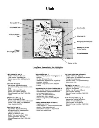
  • 1. Utah Salt Lake City Mill 11 e.(2) Disposal Site Green River Site South Clive Disposal Cell (Atlas) Moab Mill (Rio Algom) Lisbon Valley Site Monticello Mill Site and Vicinity Properties (Plateau) Shootaring Canyon Site (EFN) White Mesa Site Mexican Hat Site Long-Term Stewardship Site Highlights 11 e.(2) Disposal Site (page 3) Site Size- 14.6 hectares (36.2 acres) Current Landlord- Envirocare of Utah Expected Future Landlord- U.S. Department of Energy (Atlas) Moab Mill (page 5) Major Activities- disposal cell monitoring; groundwater monitoring; access restrictions; erosion control Site Size- 162 hectares (400 acres) Start/End Years- yet to be determined Estimated Average Annual Cost FY 2005-2006$16,500 (EFN) White Mesa Site (page 9) Site Size- 202 hectares (500 acres) Current Landlord -International Uranium Corporation Expected Future Landlord- U.S. Department of Energy, Grand Junction Office Green River Site (page 13) Major Activities- disposal cell monitoring; groundwater monitoring; access restrictions; inspections; maintenance Site Size- 10 hectares (25 acres) Start/End Years - engineered unit - 1989/in perpetuity, groundwater- 2009-2018 Estimated Average Annual Cost FY 2000-2006$88,300 Mexican Hat Site (page 17) Major Activities - groundwater monitoring; disposal cell monitoring Site Size- 48 hectare (119 acre) Start/End Years - disposal cell1997 - in perpetuity; groundwater 1999-2004 Estimated Average Annual Cost FY 2000-2006$139,000 Monticello Mill Site and Vicinity Properties (page 23) Major Activities- disposal cell monitoring; institutional control enforcement; supplemental standards area monitoring; groundwater monitoring Site Size- 2,300 hectares (5, 700 acres) Start/End Years- 2001/in perpetuity Estimated Average Annual Cost FY 2000-2006$286,000 (Plateau) Shootaring Canyon Site (page 33) Total Site Area· unknown Current Landlord- U.S. Energy Corporation through its subsidiary, Plateau Resources Limited Expected Future Landlord· U.S. Department of Energy, Grand Junction Office (Rio Algom) Lisbon Valley Site (page 37) Site Size- 130 hectares (330 acres) Current Landlord- Rio Algom through its subsidiary, Rio Algom Mining Corporation Expected Landlord- U.S. Department of Energy, Grand Junction Office Salt Lake City Mill (page 41) Major Activities- groundwater monitoring; land use restrictions; record keeping Site Size Area- 52 hectares (128 acres) Start-End Years -1989-2004 Estimated Average Annual Cost FY 2000-2006$25,000 South Clive Disposal Cell (page 45) Major Activities- disposal cell monitoring Site Size- 40 hectares (99 acres) Start/End Years -1997/in perpetuity Estimated Average Annual Cost FY 2000-2006$32,342
  • 2.
  • 3. Table of Contents Table of Contents 11e.(2) Disposal Site ..................................................................... 3 (Atlas) Moab Mill ....................................................................... 5 (EFN) White Mesa Site ................................................................... 9 Green River Site ........................................................................ 13 Mexican Hat Site ....................................................................... 17 Monticello Mill Site and Vicinity Properties ................................................. 23 (Plateau) Shootaring Canyon Site .......................................................... 33 (Rio Algom) Lisbon Valley Site ........................................................... 37 Salt Lake City Mill ..................................................................... 41 South Clive Disposal Cell ................................................................ 45 Utah 1
  • 4. National Defense Authorization Act (NDAA) Long-Term Stewardship Report Utah 2
  • 5. lle.(2) Disposal Site lle.(2) DISPOSAL SITE 1 1.0 SITE SUMMARY 1.1 Site Description and Mission Envirocare of Utah, which is a commercial low-level SITE HIGHLIGHTS waste disposal site, contains within its boundaries a disposal cell for byproduct material defined under the Total Site Area- 14.6 hectares (36.2 acres) Atomic Energy Act, as amended. This disposal cell, Estimated Volume of Residual Contaminantsknown as the "11e.(2) Disposal Site," is located 900,000 cubic meters (1 million cubic yards) approximately 137 kilometers (85 miles) west of Salt Current Landlord- Envirocare of Utah Expected Future Landlord- U.S. Department of Lake City and 4 kilometers (2.5 miles) south of U.S. Energy Interstate 80 in Tooele County, Utah. The disposal cell is currently 14.6 hectares (36.2 acres), but could ultimately be 37.1 hectares (91.7 acres) and hold up to 4.2 million cubic meters (5.5 million cubic yards) of waste. Envirocare of Utah owns a license to receive, store, and dispose of 11e.(2) byproduct material onsite. 11e.(2) byproduct material is defined by law under Section 11e.(2) of the Atomic Energy Act, as amended by Title II of the Uranium Mill Tailings Radiation Control Act of 1978, as: tailings or waste produced by the extraction or concentration of uranium or thorium from any ore processed primarily for its source material (i.e., uranium or thorium) content. A portion of the material disposed at the lle.(2) Disposal Site originated from the removal of waste from sites remediated under the Formerly Utilized Sites Remedial Action Program (FUSRAP). ~ ---------- -------·~ 0.25 0 k;I-WJi{fr>ads 0.5 Miles ~ • B ~ !! Tc S~~~a~~~;~;Y. UT -+ r--o- lu '" I' ····· i SoulhCii¥e Dlspn9a1Call To date, approximately 900,000 cubic meters (one million cubic yards) of material have been disposed in the cell. The active portion of the cell occupies 10 hectares (24.9 acres) and a cap has been placed over 4.6 hectares (11.3 acres). The disposal cell lies in a flat ancient lake bed along the eastern edge of the Great Salt Lake Desert, which extends approximately 80 kilometers (50 miles) from the Nevada/Utah border. The surrounding area is sparsely '------:: 11e.(2) Disposal She EnvirocareofU!ah lle.(2) Disposal Site 1 This report is developed in response to a Congressional request in the Fiscal Year (FY) 2000 National Defense Authorization Act (NDAA). As requested by the Act, this report addresses current and anticipated longterm stewardship activities at each site or portion of a site by the end of calendar year 2006 ("Conference Report on S.l059, National Defense Authorization Act for Fiscal Year 2000," Congressional Record, August 5, 1999). Based on current planning, the lle.(2) Disposal Site is not expected to require long-term stewardship until after 2006, and for this reason the site is not the primary focus of this report. This brief summary of the site cleanup activities is provided for background information and potential future long-term stewardship activities. (See Section 3.2 of Volume I). Utah 3
  • 6. National Defense Authorization Act (NDAA) Long-Term Stewardship Report populated, with the nearest residences at least 48 kilometers (30 miles) from the site. Roads in the area are used for recreation and for access to military firing ranges south of the site. Vegetation in the area is sparse, and the semi-arid low shrub land is used primarily for grazing. For additional information about the lle.(2) Disposal Site, please contact: Envirocare of Utah, Inc. Suite 116 46 W. Broadway Salt Lake City, UT 84101-2019 Phone: 801-532-1330 Utah 4
  • 7. (Atlas) Moab Mill (ATLAS) MOAB MILL 1.0 SITE SUMMARY 1.1 Site Description and Mission The (Atlas) Moab Mill is the location of a former uranium milling site that operated from 1956 until1988. The site is located on 162 hectares (400 acres) of land on the northwest shore of the Colorado River in Grand County, Utah, approximately 5 kilometers (3 miles) from the city of Moab. Adjacent to the mill on the north and west are U.S. Highway 191 and Utah Highway 279, respectively. Arches National Park is north of the site across U.S. Highway 191. The Rio Grande Railroad traverses a small section of the property, just west of Highway 279. Milling operations at the site created uranium mill tailings and other process-related wastes, which occupy approximately 53 hectares (130 acres) of the site and are located about 230 meters (750 feet) from the Colorado River. LONG-TERM STEWARDSHIP HIGHLIGHTS Major Long-Term Stewardship Activities -yet to be determined Total Site Area- 162 hectares (400 acres) Estimated Volume of Residual Contaminants- groundwater unknown; surface water unknown; soil unknown Long-Term Stewardship Start-End Years- yet to be determined* Average Annual Long-Term Stewardship Cost FY 2005-2006- $16,500 Landlord- U.S. Department of Energy, Grand Junction Office *The long-term stewardship start and end years will depend on the remedial action selected and completion date. Longterm stewardship activities are not expected to begin until after 2006. The current mission of the (Atlas) Moab Mill site has been modified by the National Defense Authorization Act (NDAA) for Fiscal Year (FY) 2001. The U.S. Department of Energy (DOE) will be responsible for conducting long-term stewardship activities at the site, if any are necessary. In the NDAA forFY 2001, the (Atlas) Moab Mill site'sremediation schedule and plans were changed. To satisfy the site's remediation procedures in the NDAA for FY 2001, DOE must prepare a remediation plan for the site, in accordance with Title I of the Uranium Mill Tailings Radiation Control Act of 1978 (UMTRCA), that includes considering the relocation of the mill tailings and contaminated media to an offsite disposal cell (most likely a disposal cell constructed specifically to contain the remediated materials from the (Atlas) Moab Mill site) and restoration of the groundwater. As part of the development of this remediation plan, DOE must cooperate with the National Academy of Sciences and thoughtfully consider its recommendations on various remedial alternatives. Also, DOE will develop, in consultation with the Trustee, NRC, and the State of Utah, an efficient and legal means for transferring all responsibilities and title of the (Atlas) Moab Mill site, and all the materials therein, from the Trustee to DOE. This remediation plan must be completed no later than one year after the date of the enactment of the NDAA for FY 2001; and DOE must begin remedial action at the site as soon as practicable after the completion of the plan. The license for the materials at the (Atlas) Moab Mill site, issued by NRC, will terminate one year after the date ofthe enactment of the NDAA for FY 2001, unless DOE determines that the license can be terminated earlier. Until the license is terminated, the Trustee, subject to the availability of funds appropriated specifically for the site's remediation or the funds made available by the Trustee from the site's trust, may carry out (1) interim measures to reduce or eliminate the localized high ammonia concentrations in the Colorado River; (2) activities to dewater the mill tailings at the site; and (3) other activities related to the site, subject to the authority of the NRC and in consultation with DOE. The historical mission of the uranium milling site was to process uranium for sale to the U.S. Government and Utah 5
  • 8. National Defense Authorization Act (NDAA) Long-Term Stewardship Report other industries. More than half of the uranium produced at the site was used to support the U.S. Government national defense program. The Uranium Reduction Company (URC) built the (Atlas) Moab Mill and began operations in October 1956. Atlas Corporation purchased the site from URC in 1962 and operated the mill until 1984. The majority of the ore processed at the (Atlas) Moab Mill was transported to the mill from the Big Indian Uranium District, approximately 48 kilometers (30 miles) to the southeast. The ore was ground to a sufficiently fine consistency to allow efficient chemical reactions to occur, and was then processed, using either the acid-leach or alkaline-leach process. After milling, the combined waste slurry from both processes was pumped into the tailings impoundment. 1.2 (MosfMoap~ill, ···.-,~ e!Moab To G~~ 5J~~~~~- co Jf -~~~;;;a;---;;-~;;;,co (-240miles) . . '1-. (Rio AJgom) Lispon Valley Site •. Site Cleanup and Accomplishments 20 10 0 Contamination at the (Atlas) Moab Mill Miles resulted from the previous uranium milling operations conducted by URC and Atlas (Atlas) Moab Mill Corporation. Approximately 10,500,000 tons of uranium mill tailings are currently located on the site. In addition to the tailings, soil and building debris are contaminated with uranium, radium, and thorium. In 1988, the Atlas Corporation began decommissioning the site and constructing an interim cover for the tailings disposal area. The former mill was decommissioned and the wastes were consolidated under an interim cover that was completed in 1995. In 1998, the Atlas Corporation declared bankruptcy. As a result ofthe bankruptcy proceedings, the Moab Uranium Mill Site Transfer Agreement was established, which provided for the transfer of the site's NRC license to a trustee that was to be responsible for completing the site's remediation. In January 2000, PricewaterhouseCoopers was selected as the trustee and agreed to oversee and ensure that remediation of the (Atlas) Moab Mill was completed in accordance with the conditions of the NRC license and the site's transfer agreement. However, as stated above, the Trustee will relinquish all responsibility to DOE within one year of enactment of the NDAA for FY 2001. Groundwater at the site is contaminated with radioactive materials, including radium and uranium, and nitrogen compounds from the uranium ore processing. The Colorado River is contaminated with localized, high concentrations of ammonia. The initial monitoring program of water resources at and around the site began in 1976, after approximately 20 years of mill operation. The monitoring program was designed to collect surface water samples from the Colorado River and groundwater samples from the alluvial aquifer situated beneath the tailings impoundment. NRC has indicated that remediating contaminated groundwater will require a substantially longer period of time than will be involved in the surface reclamation of the mill tailings. Utah 6
  • 9. (Atlas) Moab Mill 2.0 SITE-WIDE LONG-TERM STEWARDSHIP 2.1 Long-Term Stewardship Activities The DOE Grand Junction Office will be responsible for performing long-term stewardship activities at the (Atlas) Moab Mill site, if any are required. The types of long-term stewardship activities that may be needed at the site will not be known until the site's remediation plan is prepared and the remedial action is completed. DOE provides a 24-hour phone line for reporting site concerns. Site records will be kept in permanent storage at the DOE Grand Junction Office in Colorado. The types of records that will be maintained include site characterization data, remedial action design information, the radiological assessment, long-term monitoring plans, annual inspection reports, and current and historic monitoring data. 2.2 Specific Long-Term Stewardship Activities STAKEHOWER INVOLVEMENT Groundwater The groundwater is expected to require annual monitoring. The specific monitoring requirements will be prescribed in the site's long-term surveillance plan that will be developed after remediation is completed, and if long-term stewardship activities are required. Surface Water/Sediments DOE will assume the lead role in stakeholder involvement during remedial action as a result of the NDAA for FY 2001. Once remediation is complete, the annual inspection reports for the (Atlas) Moab Mill will be distributed to the local libraries and to any stakeholders requesting them. The reports, once published, will be available on the DOE Grand Junction Office website at www.doegjpo.com. The surface water may require periodic monitoring if it is not completely cleaned up during the site's remedial action. The specific monitoring requirements will be prescribed in the site's long-term surveillance plan that will be developed after remediation is completed, and if long-term stewardship activities are required. 2.3 Regulatory Regime The long-term stewardship activities, if required, at the (Atlas) Moab Mill will be governed by several requirements in the following regulations: Title I ofUMTRCA; the Atomic Energy Act; EPA standards, including Title 40 of the Code of Federal Regulations, Part 192 Subparts B and C; and the National Environmental Policy Act, as amended. 2.4 Assumptions and Uncertainties The site's remediation strategy has not yet been selected. DOE assumes that the tailings will be removed to an offsite disposal cell. The costs for conducting long-term stewardship activities at an offsite disposal cell will be similar to other UMTRCA Title II, offsite disposal cells. The (Atlas) Moab Mill site will undergo groundwater restoration activities for a currently undetermined length of time; after which, the site is expected to be eligible for unrestricted use. 3.0 ESTIMATED LONG-TERM STEWARDSHIP COSTS The cost estimates, identified in the table below, are based on the actual costs of long-term stewardship activities at other similar sites under DOE's management. Actual costs will vary depending upon the groundwater Utah 7
  • 10. National Defense Authorization Act (NDAA) Long-Term Stewardship Report sampling frequency, number of analyses sampled, and the number of sampling points (e.g., wells). Contingency costs, such as cap replacement, have not been incorporated in the cost estimates. Site Long-Term Stewardship Costs (Constant Year 2000 Dollars) Year(s) Amount Year(s) Amount Year(s) Amount FY2000 $0 FY2008 $16,500 FY 2036-2040 $81,800 FY 2001 $0 FY 2009 $16,500 FY 2041-2045 $81,800 FY 2002 $0 FY2010 $16,500 FY 2046-2050 $81,800 FY 2003 $0 FY 2011-2015 $78,500 FY 2051-2055 $81,800 FY 2004 $0 FY 2016-2020 $76,400 FY 2056-2060 $81,800 FY 2005 $16,500 FY 2021-2025 $76,600 FY 2061-2065 $81,800 FY 2006 $16,500 FY 2026-2030 $81,000 FY 2066-2070 $81,800 FY 2007 $16,500 FY 2031-2035 $81,800 4.0 FUTURE USES Assuming that the contaminated materials are relocated to an offsite disposal cell, title to the (Atlas) Moab Mill site will likely be transferred or sold after remediation activities at the site are completed. The future use of the site will depend on the remedial action that is selected in the site's remediation plan, but DOE anticipates that the site will ultimately be remediated to unrestricted use. The associated, anticipated disposal cell will be a permanent mill tailings repository under DOE ownership with the necessary use restrictions. For more information about the (Atlas) Moab Mill site, please contact: Art Kleinrath, Long-Term Surveillance and Maintenance Program Manager U.S. Department of Energy, Grand Junction Office 2597 B3/4 Road, Grand Junction, CO 81503 Phone: 970-248-6037 or visit the Internet website at http://www.doegjpo.com Utah 8
  • 11. (EFN) White Mesa Site (EFN) WHITE MESA SITE 1 1.0 SITE SUMMARY 1.1 Site Description and Mission The (EFN) White Mesa Site is the location of a currently operating uranium milling site. The site is located in San Juan County, Utah, approximately eight kilometers (five miles) south of Blanding. The (EFN) White Mesa site is currently owned and operated by the International Uranium Corporation (formerly owned and operated by Energy Fuels Nuclear, Inc). The site covers approximately 202 hectares (500 acres). LONG-TERM STEWARDSHIP HIGHLIGHTS Total Site Area- 202 hectares (500 acres) Current Landlord- International Uranium Corporation Expected Future Landlord- U.S. Department of Energy, Grand Junction Office Reason Not Subject to NDAA Requirements - This site is an UMTRCA Title II site that will not be transferred to DOE until 2025 Once the site is transferred to DOE in 2025, the only site mission will be the long-term surveillance and maintenance of the disposal cell. The exact number of acres that will be transferred to DOE has not yet been determined. The current and historic mission of the site is to extract uranium oxide concentrate (commonly called yellowcake) from uranium ores found in the region. The (EFN) White Mesa Site uranium milling site was constructed in the late 1970s by Energy Fuels Nuclear, Inc. to process uranium ores from the Colorado Plateau. After two- and-ahalf years of operation, the mill was shut down. In May 1997, International Uranium Corporation, the current owner and site operator, purchased the mill assets. The mill operated intermittently throughout the 1980s and 1990s and is currently in operation. From its inception through April 1999, the mill processed a total of 3.8 million tons of uranium ore. 1.2 Site Cleanup and Accomplishments The International Uranium Corporation will be responsible for conducting all remediation activities at the (EFN) White Mesa site. All contamination at the site will be remediated and disposed of in two onsite disposal cells. Materials and debris associated with the decommissioning of the mill facility will be placed in one of the lined disposal cells. Contaminated soils, crystals, and the synthetic liner from an existing evaporation pond will be consolidated in the other cell, along with offsite soils contaminated by wind-blown mill tailings. When remediation activities are completed, the site will have two disposal cells containing approximately two million cubic meters (2.6 million cubic yards) of uranium mill tailings. The precise size of the disposal cells will not be known until remediation is completed. Once the cells reach capacity, they will be capped with a one-meter (three-foot) layer of soil, followed by a layer of compacted clay and eight-to-20 centimeters (three-to-eight inches) of rock riprap for erosion control. The cells will be designed to limit the infiltration of precipitation, 1 This report is developed in response to a Congressional request in the Fiscal Year (FY) 2000 National Defense Authorization Act (NDAA). As requested by the Act, this report addresses current and anticipated longterm stewardship activities at each site or portion of a site by the end of calendar year 2006 ("Conference Report on S.l059, National Defense Authorization Act for Fiscal Year 2000," Congressional Record, August 5, 1999). Based on current planning, the (EFN) White Mesa Site is not expected to be transferred to the U.S. Department of Energy (DOE) for long-term stewardship until 2025, and for this reason the site is not the primary focus of this report. This brief summary of the site cleanup activities is provided for background information and potential future long-term stewardship activities. (See Section 3.2 of Volume I). Utah 9
  • 12. National Defense Authorization Act (NDAA) Long-Term Stewardship Report prevent erosion, and control radon gas releases. No groundwater contamination has been detected by the site's existing groundwater detection monitoring program. Because contamination has not been detected, the U.S. Nuclear Regulatory Commission (NRC) Reclamation Plan for the (EFN) White Mesa Site does not require any corrective measures for groundwater. J Wayne County ToSol!LokeCoy,UT (•180mUes) / . (Plateau) Shootaring Canyon Site "" )( ' -~~~~7~--~~-----~ . /(-.... ,~ )../ / .---------------~--~} 0 15 30 Miles (EFN) White Mesa Site 2.0 EXPECTED FUTURE USES AND SITE RESPONSIBILITY Once the (EFN) White Mesa Site is transferred to DOE in 2025, the DOE Grand Junction Office will be responsible for long-term stewardship activities. The two disposal cells at the site will be similar to other uranium mill tailings disposal cells and will have similar long-term stewardship activities. Anticipated site-wide long-term stewardship activities include restricting access by fencing and posting warning signs along the site boundary. DOE will repair the fence and replace the signs, as necessary. DOE will staff a 24-hour phone line for reporting site concerns. Drilling and other intrusive activities will be prevented within site boundaries through institutional controls. DOE expects to conduct annual surface inspections to ensure the integrity of the disposal cell covers and other engineered features. Groundwater is likely to be monitored annually as a "best management" practice. Site records will be placed in permanent storage at the DOE Grand Junction Office in Colorado. The types of records maintained include site characterization data, remedial action design information, the site completion report, long-term monitoring plans, annual inspection reports, and current and historic monitoring data. Utah 10
  • 13. (EFN) White Mesa Site For additional information about the (EFN) White Mesa Site, please contact: Art Kleinrath, Long-Term Surveillance and Maintenance Program Manager U.S. Department of Energy, Grand Junction Office 2597 B3/4 Road Grand Junction, CO 81503 Phone:970-248-6037 or visit the Internet website at http://www.doegjpo.com Utah Bill Von Till, Project Manager Uranium Recovery and Low-Level Waste Branch U.S. Nuclear Regulatory Commission Mail Stop 7J8 Washington, DC 20555-001 Phone: 301-415-6351 or visit the Internet website at http://www.nrc.gov 11
  • 14. National Defense Authorization Act (NDAA) Long-Term Stewardship Report Utah 12
  • 15. Green River Site GREEN RIVER SITE 1.0 SITE SUMMARY 1.1 Site Description and Mission The Green River Site is the location of a former uranium milling site that operated between 1958 and 1961. The site covers approximately 10 hectares (25 acres) and is located in Grand County in the east-central portion of Utah. The site is 1.6 kilometers (one mile) southeast of the City of Green River and 113 kilometers (70 miles) west of the Utah-Colorado border. The U.S. Army's White Sands Missile Range, Utah Launch Complex, uses most of the vacant land south and east of the site. Agriculture is the predominant land use in this sparsely populated area. LONG-TERM STEWARDSHIP HIGHLIGHTS Major Long-Term Stewardship Activities- disposal cell monitoring; groundwater monitoring; access restrictions; inspections; maintenance Total Site Area- 10 hectares (25 acres) Estimated Volume of Residual Contaminants- engineered unit 292,200 cubic meters (382,000 cubic yards); groundwater 685,200 cubic meters (181 million gallons) Long-Term Stewardship Start-End Years- engineered unit- 1998-in perpetuity; groundwater- 2009-2018 Average Annual Long-Term Stewardship Cost FY The milling operations used to process the uranium ore 2000-2006- $88,300 created approximately 292,200 cubic meters (382,000 Landlord- U.S. Department of Energy, Grand cubic yards) of process-related waste and uranium mill Junction Office tailings. The tailings were originally deposited onsite in a two-meter (seven-foot) thick pile covering four hectares (nine acres). The U.S. Department of Energy (DOE) encapsulated the tailings in an engineered disposal cell in 1989. The current mission of the Green River Site is monitoring and maintaining the onsite disposal cell. The site is subject to Title I of the Uranium Mill Tailings Radiation Control Act of 1978 (UMTRCA). As such, DOE is responsible for remediation and long-term stewardship activities of the site. DOE began long-term stewardship activities for the engineered unit in 1998. The historic mission of the Green River site was to provide uranium for the U.S. Government's national defense program. Union Carbide built the uranium processing mill in 1958 and operated it until1961. Later, the mill buildings were used for assembly of missile components for the Utah Launch Complex. The State of Utah acquired ownership of the mill and tailings site in 1988. 1.2 Site Cleanup and Accomplishments Remediation of the site involved consolidating and stabilizing the residual radioactive material in a disposal cell at the former processing site and remediating 17 vicinity properties. The State of Utah and the U.S. Nuclear Regulatory Commission (NRC) concurred in DOE's decision to consolidate the tailings onsite in an engineered disposal cell. Radioactive materials from the original pile, the demolished or decontaminated mill buildings, and contaminated vicinity properties were consolidated into a U.S. Environmental Protection Agency (EPA)-compliant disposal cell. The cell was excavated to bedrock and lined with two meters (six feet) of low-permeability soil. The cell measures 137 meters (449 feet) by 162 meters (532 feet) at the base and rises 13 meters (43 feet) above the surrounding land. Most of the contaminated materials are below grade. Approximately 292,200 cubic meters (382,000 cubic yards) of contaminated materials, including uranium, radium, and thorium, were placed in the 2.5-hectare (six-acre) cell (equivalent to 501,000 dry tons of contaminated material with an estimated activity Utah 13
  • 16. National Defense Authorization Act (NDAA) Long-Tenn Stewardship Report of 30 curies of radium-226). A clay-rich soil layer placed over the contaminated materials extends to the edge of the cell below grade and serves as a low permeability radon barrier. Above grade, the radon barrier is covered by a layer of rock placed on granular bedding material. The cell design promotes rapid precipitation runoff to minimize leachate. Surface remedial action was completed in September 1989. @ Groundwater Monitoring Well ~ GroundwaterContaminanon 0 0.1 To Grand Junction, CO (·B5miles) .. Green River Site Approximately 685,200 cubic meters (181 million gallons) of groundwater in the vicinity of the Green River Site are contaminated with materials generated during uranium ores processing. Uranium processing-related contaminants have been identified in the alluvium and in the upper Cedar Mountain Formation beneath the site. An upward hydraulic gradient prevents these contaminants from migrating into lower strata. Groundwater in these aquifers is not suitable for agricultural or domestic use because of naturally occurring contamination and low water yields. The groundwater is not a current or potential source of drinking water, as defined in Title 40 of the Code of Federal Regulations, Part 192. Therefore, no active groundwater remediation is planned. DOE is currently monitoring groundwater to provide additional characterization and to develop a groundwater compliance strategy for regulatory approval. 2.0 SITE· WIDE LONG-TERM STEWARDSHIP 2.1 Long-Term Stewardship Activities The DOE Grand Junction Office manages the site according to a long-term surveillance plan prepared specifically for the Green River Site. Under provisions of the plan, the Grand Junction Office conducts annual Utah STAKEHOLDER INVOLVEMENT Community interaction has been minimal since the surface remedial action was completed. Copies of the annual inspection report for Green River Site and other sites are distributed to the local library and to any stakeholders requesting them. The annual inspection reports are also published on the DOE Grand Junction Office website at www.doegjpo.com .. 14
  • 17. Green River Site inspections of the site to evaluate the condition of surface features. DOE also performs site maintenance, such as fence repair and sign replacements, as necessary. A locked security fence surrounds the perimeter of the cell to control access. The disposal site is owned by the Federal Government, which controls land use within the site boundaries. DOE performs long-term stewardship activities, as required under the NRC general license (10 CPR 40.27), to maintain protectiveness of the remedy and to ensure compliance with the applicable regulations. A chain- link fence with locked gates restricts access to the disposal cell, and warning signs are posted every 152 meters (500 feet) along the site boundary. DOE staffs a 24-hour phone line for reporting site concerns. Drilling and other intrusive activities are prevented within site boundaries through the use of institutional controls. DOE maintains and updates specific records and reports required to document the long-term stewardship activities at the Green River Site. DOE submits an annual report to NRC that documents the results of the longterm surveillance plan, as required by NRC regulations in Title 10 of the Code of Federal Regulations Part 27, Appendix A, Criterion 12. Site records are kept in permanent storage at the DOE Grand Junction Office in Colorado and are available for review by the public. The types of records maintained include site characterization data, remedial action design information, the site completion report, long-term monitoring plans, annual inspection reports, and current and historic monitoring data. Real property records are maintained at the DOE Albuquerque Operations Office in New Mexico. 2.2 Specific Long-Term Stewardship Activities Engineered units Long-term stewardship activities for the disposal cell include conducting annual inspections to assess the integrity of the cell cover and other engineered features, and ensuring effectiveness of institutional controls. No significant repairs are anticipated for the disposal cell. The Green River Site disposal cell is designed and constructed to last for 200 to 1,000 years. However, DOE's responsibility for the safety and integrity of the Green River Site will continue in perpetuity. Under the provisions of the long-term stewardship plan, DOE will monitor groundwater on a quarterly basis through at least 2001 to demonstrate the effectiveness of the cell in isolating the encapsulated wastes from the groundwater. After 2001, the groundwater monitoring strategy will be reevaluated. It is expected to continue beyond 2001, but at a reduced frequency. Groundwater No groundwater remediation occurred at the Green River Site because of the already high levels of naturally occurring constituents in the groundwater. DOE is currently developing a groundwater compliance strategy for regulatory approval. The monitoring frequency and duration will be determined by the compliance strategy. Current planning assumes that DOE will monitor the groundwater once every five years until2018. 2.3 Regulatory Regime In 1998, the Green River Site came under a general license issued by NRC for custody and long-term care of residual radioactive disposal sites (contained in Title 10 of the Code ofFederal Regulations, Section 40.27). The purpose of the general license is to ensure that such sites will be cared for in a manner that protects human health and safety and the environment. The general license went into effect when NRC agreed that the site conformed to cleanup standards and formally accepted the site's long-term surveillance plan. Long-term stewardship activities at the Green River Site are governed by several requirements in the following regulations: UMTRCA; the Atomic Energy Act of 1954, as amended; EPA Groundwater Protection Standards, Utah 15
  • 18. National Defense Authorization Act (NOAA) Long-Term Stewardship Report including Subparts A, B, and C of Title 40 of the Code of Federal Regulations Part 192; and the National Environmental Policy Act of 1969, as amended. 2.4 Assumptions and Uncertainties Because long-term stewardship activities have been conducted since 1998, the long-term stewardship activities at the site are well known and are not expected to change dramatically. DOE expects that the disposal cap will not need to be replaced for a minimum of 200 years. Groundwater and disposal cell monitoring will occur in perpetuity. 3.0 ESTIMATED LONG-TERM STEWARDSHIP COSTS Long-term stewardship costs for the Green River Site are based on historical costs incurred while conducting actual surveillance and maintenance activities. Costs for fiscal years (FY) 2001 through 2006 include prorated costs associated with decommissioning unnecessary monitoring wells at similar sites. Contingency costs, such as cap replacement, have not been incorporated in the cost estimates. Site Long-Term Stewardship Costs (Constant Year 2000 Dollars) Year(s) Amount Year(s) Amount Year(s) Amount FY 2000 $41,000 FY 2008 $29,000 FY 2036-2040 $142,400 FY 2001 $105,200 FY 2009 $29,000 FY 2041-2045 $142,200 FY2002 $111,400 FY 2010 $29,000 FY 2046-2050 $142,400 FY 2003 $99,400 FY 2011-2015 $129,700 FY 2051-2055 $142,200 FY 2004 $112,200 FY 2016-2020 $129,600 FY 2056-2060 $142,400 FY 2005 $73,900 FY 2021-2025 $132,800 FY 2061-2065 $142,200 FY 2006 $75,100 FY 2026-2030 $141,000 FY 2066-2070 $142,400 FY 2007 $29,200 FY 2031-2035 $142,200 4.0 FUTURE USES The future use of the site will be restricted to long-term monitoring and maintenance of the disposal cell in perpetuity. For more information about the Green River Site, please contact: Art K1einrath, Long-Term Surveillance and Maintenance Program Manager U.S. Department of Energy, Grand Junction Office 2597 B3/4 Road, Grand Junction, CO 81503 Phone: 970-248-6037 or visit the Internet website at http://www.doegjpo.com Utah 16
  • 19. Mexican Hat Site MEXICAN HAT SITE 1.0 SITE SUMMARY 1.1 Site Description and Mission The Mexican Hat Site is the location of a former uranium processing mill that operated from 1957 until 1965, and a sulfuric acid plant that operated from 1957 to 1970. The site also contains a disposal cell for the uranium mill tailings and other process-related wastes from the former mill at the site and from the Monument Valley Site in Arizona). The Mexican Hat Site is located on Navajo Nation land in San Juan County, Utah, east of U.S. Highway 163. The 48-hectare (119acre) site lies between the towns of Halchita and Mexican Hat, approximately 13 kilometers (18 miles) southwest of Bluff, Utah, and 16 kilometers (10 miles) north of the Arizona border. LONG-TERM STEWARDSHIP HIGHLIGHTS Major Long-Term Stewardship Activities groundwater monitoring; disposal cell monitoring Total Site Area- 48 hectares (119 acres) Estimated Volume of Residual Contaminants- disposal cell2.66 million cubic meters (3.48 million cubic yards); groundwater 416,400 cubic meters (544,600 cubic yards) Long-Term Stewardship Start-End Years- disposal cell1997-in perpetuity; groundwater 1999-2004 Average Annual Long-Term Stewardship Cost FY 2000-2006-$139,000 Landlord- U.S. Department of Energy, Grand Junction Office; Navajo Nation Contamination of the site resulted from previous uranium milling and acid production operations. The milling operations created process-related wastes and tailings. Before remedial action was completed, the site consisted of two tailings piles totaling 29 hectares (72 acres). One covered 10 hectares (25 acres) and the other covered 19 hectares (47 acres). The site also contained seven mill buildings and associated debris, a concrete pad, contaminated soil, and wind-blown material. An estimated 2.2 million cubic meters (2.8 million cubic yards) of contaminated material were contained in these two tailings piles and on an additional! 01 hectares (250 acres) of adjacent land. The contaminated material at this site and contaminated material from the Monument Valley Site was stabilized in a 29-hectare (72-acre) disposal cell at the Mexican Hat Site. The U.S. Department of Energy (DOE) closed the cell and completed surface remediation of the site in January 1995. The current mission of the Mexican Hat Site is to perform long-term stewardship activities, including disposal cell monitoring and the groundwater monitoring at the former mill site. The site is subject to Title I of the Uranium Mill Tailings Radiation Control Act of 1978 (UMTRCA). As such, DOE is responsible for any remediation and long-term stewardship activities. DOE began conducting long-term stewardship activities at the site in 1997. The historic mission of the Mexican Hat Site was to process uranium for sale to the U.S. Government. The mill at the site was constructed and operated from 1957 to 1963 by Texas-Zinc Minerals Corporation. The Atlas Corporation purchased the mill in 1963 and operated it until it was closed in 1965. When the Atlas lease expired in 1970, control of the site reverted to the Navajo Nation. Much of the ore processed at the Mexican Hat Site came from the White Canyon area of Utah and contained a considerable amount of copper sulfide and other sulfide minerals. During its operation, the uranium mill processed 2.2 million tons of ore and produced 5,700 tons of uranium concentrate. At the time of the remedial action, the concrete pad for the mill building and several associated buildings and structures (e.g., scale house, office building, and tanks) were left in place. One or two of the smaller buildings appeared to be used for storage, and the Navajo Tribal Utility Authority operated a small electrical substation and sewage system (three lagoons) at the site. Access to the site was not restricted; however, the Navajo Environmental Protection Administration has discouraged any activity at the site since 1978. Utah 17
  • 20. National Defense Authorization Act (NDAA) Long-Term Stcwardshi)l Report ~ Groundwater Contamination 0.25 0.5 Miles To Salt Lake City, UT (-275 miles) El<tent of Contamination Unknown Monument Valley Site (-12 miles) ~ Mexican Hat Site The Mexican Hat Site is also the repository for residual radioactive material from the Monument Valley Site and eleven vicinity properties. The Monument Valley Site's residual radioactive material was transported to the Mexican Hat Site and was placed on top of the residual radioactive material in the disposal cell. 1.2 Site Cleanup and Accomplishments The source of contamination at the Mexican Hat Site was the residual tailings that remained after the milling process extracted the uranium. DOE completed surface remedial actions in 1995 under the provisions of the Uranium Mill Tailings Radiation Control Act of 1978 (UMTRCA), in accordance with a remedial action plan approved by the U.S. Nuclear Regulatory Agency (NRC). Remedial action involved consolidation of approximately 2 million cubic meters (2.66 million cubic yards) of residual radioactive material in place at the bottom of what is now the Mexican Hat disposal cell, followed by placement of approximately 703,200 cubic meters (925,200 cubic yards) of residual radioactive material from the Monument Valley Site, for a total of approximately 2.66 million cubic meters (3.48 million cubic yards) of residual radioactive material. Eleven vicinity properties were also remediated concurrent with site remediation activities. The final disposal cell covers approximately 29 hectares (72 acres). The disposal cell includes a radon cover and rock surface layer to control erosion. In accordance with U.S. Environmental Protection Agency (EPA) standards, the disposal cell was designed to remain effective for 200 to 1,000 years. Groundwater contamination at the Mexican Hat Site was caused by the discharge of waste water and tailings from uranium milling. Seepage of construction water resulting from consolidation during material compaction may have contributed to the contamination. Approximately 416,400 cubic meters (544,600 cubic yards) of Utah 18
  • 21. Mexican Hat Site groundwater are contaminated with nitrate, molybdenum, selenium, uranium, net gross alpha, arsenic, chromium, and radium. Contamination is present in the residual process water within the upper part of the Halgaito Formation. The former uranium mill was the largest source of contamination. The sulfuric acid plant probably contributed little additional contamination when compared to the uranium mill. The approved groundwater compliance strategy for the Mexican Hat Site is to perform no remediation and to continue monitoring the seeps below the disposal cell. Site data indicate that groundwater in the uppermost aquifer (the lower unit of the Halgaito Formation) beneath the site is not suitable for use because of the presence of hydrogen sulfide and hydrocarbons. Contamination introduced from uranium processing is present in the perched, ephemeral groundwater system at a higher stratigraphic level in the Halgaito Formation. Based upon data from intermittent seeps downgradient of the disposal cell, it appears that flow rates may be decreasing, and may cease over time. Monitoring of contaminant concentrations in the seeps will continue as long as water is present. 2.0 SITE-WIDE LONG-TERM STEWARDSHIP 2.1 Long-Term Stewardship Activities The DOE Grand Junction Office is responsible for performing long-term stewardship activities at the Mexican Hat Site, including maintaining access restrictions and enforcing institutional controls. DOE will also conduct annual inspections of the site to evaluate the condition of surface features, perform site maintenance, as necessary, and monitor the groundwater in the seeps. The seeps will be monitored below the disposal cell for flow rate and contaminant levels to demonstrate the effectiveness of the cell in isolating the encapsulated wastes from the local groundwater system until 2004. No drilling or other intrusive activities are allowed within the property. The site records for the Mexican Hat Site are kept in permanent storage at DOE's Grand Junction Office Colorado. The types of records kept include the characterization data, remedial action design, completion report, long-term monitoring plan, annual inspection reports, and monitoring data. 2.2 Specific Long-Term Stewardship Activities Engineered Units The disposal cell contains 4,400,000 dry tons of STAKEHOLDER INVOLVEMENT contaminated material, with a total activity of 1,800 curies of radium-226. The disposal cell measures 394 Frequent meeting with representatives of the Navajo meters by 591 meters (1,200 feet by 1,800 feet) at the Nation have been held during remediation and since. Tribal members frequently participate in sampling base and occupies an area of 29 hectares (72 acres) on events and annual inspections. Copies of the annual the 49-hectare (119-acre) site. It abuts a rock outcrop inspection report for this site are distributed to the on the south and rises 16 meters (50 feet) above the local library and any stakeholders that request copies. surrounding land on the other sides. A posted wire The report is also published on the GJO website at fence surrounds the cell. A low-permeability radon www.doegjpo.com. barrier, consisting of clayey soil, covers the contaminated materials to prevent precipitation from percolating into the underlying tailings and to reduce radon emissions. The radon barrier is covered by granular bedding material and a layer of rock (riprap) on the top, the side slopes, and the aprons. The cell design promotes rapid runoff of precipitation to minimize leachate. Runoff water flows down the slide slopes into the surrounding rock apron. The site location and design were selected to minimize the potential for erosion from onsite runoff or storm water flow. All surrounding remediated areas were regraded and reseeded with native species. Existing gullies in the vicinity of the cell were turned into trenches by excavating the gullies down to the underlying bedrock. Riprap-protected diversion ditches were Utah 19
  • 22. National Defense Authorization Act (NDAA) Long-Term StewardshiJl Report installed to channel runoff water away from the cell. The rock cover on the top and side slopes of the disposal cell also prevents erosion. The stock fence prevents unauthorized access to the property. The disposal cell is designed to last for 200 to 1,000 years. However, DOE's responsibility for the safety and integrity of the Mexican Hat Site will last indefinitely. DOE has a permanent agreement with the Navajo Nation for access to the site. Groundwater Monitoring of springs and seeps will be conducted from 1999 to 2004. 2.3 Regulatory Regime In 1997, the Mexican Hat Site came under a general license issued by NRC for custody and long-term care of residual radioactive disposal sites (contained at Title 10 of the Code ofFederal Regulations, Section 40.27). The purpose of the general license is to ensure that such sites will be cared for in a manner that protects human health and safety and the environment. The general license went into effect when NRC concurred that the site conformed to cleanup standards and formally accepted the site-specific long-term surveillance plan. Long-term stewardship activities of the Mexican Hat Site are governed by several requirements in the following regulations: UMTRCA; the Atomic Energy Act of 1954, as amended; EPA Groundwater Protection Standards, including Subparts A, B, and C of Title 40 of the Code ofFederal Regulations Part 192; a cooperative agreement between DOE and the State of Utah; a cooperative agreement between DOE and the Navajo Nation; and the National Environmental Policy Act of 1969, as amended. 2.4 Assumptions and Uncertainties DOE assumes that groundwater compliance monitoring will be required in perpetuity. DOE assumes that the site is institutionally and physically stable. Because DOE is already conducting long-term stewardship activities at the site, activities are well known and are not expected to change dramatically. Caps are expected to last for a minimum of 200 years. 3.0 ESTIMATED LONG-TERM STEWARDSHIP COSTS Site Long-Term Stewardship Costs (Constant Year 2000 Dollars) Year(s) Amount Year(s) Amount Year(s) Amount FY 2000 $118,300 FY 2008 $47,700 FY 2036-2040 $222,800 FY 2001 $155,700 FY2009 $47,300 FY 2041-2045 $229,400 FY 2002 $164,500 FY 2010 $47,400 FY 2046-2050 $222,900 FY 2003 $147,400 FY 2011-2015 $209,100 FY 2051-2055 $229,400 FY 2004 $165,500 FY 2016-2020 $214,100 FY 2056-2060 $222,800 FY 2005 $111,100 FY 2021-2025 $220,700 FY 2061-2065 $229,400 FY 2006 $112,900 FY 2026-2030 $220,400 FY 2066-2070 $222,900 FY 2007 $47,700 FY 2031-2035 $222,800
  • 23. Mexican Hat Site The following table shows the estimated long-term stewardship costs for the Mexican Hat Site. Fiscal Years (FY) 2000 through 2006 include costs for well decommissioning. Cost estimates reflect the current site agreements and monitoring frequencies. Because DOE is already conducting long-term stewardship activities at the site, cost estimates are based on the actual cost of those activities. 4.0 FUTURE USES The Mexican Hat Site and the adjacent property is owned by the Navajo Nation, which controls land use within site boundaries. However, the long-term surveillance of the disposal cell is the responsibility of DOE through a Custodial Access Agreement between the Navajo Nation and the Federal Government. Provisions of the Custodial Access Agreement grant DOE permanent access to the disposal cell and include restrictions, as necessary, to protect public health and safety, and the environment. Under the provisions of this agreement, public access to the disposal cell is restricted indefinitely. For more information about the Mexican Hat Site, please contact: Art Kleinrath, Long-Term Surveillance and Maintenance Program Manager U.S. Department of Energy, Grand Junction Office 2597 B3/4 Road, Grand Junction, CO 81503 Phone: 970-248-6037 or visit the Internet website at http://www.doegjpo.com Utah 21
  • 24. National Defense Authorization Act (NOAA) Long-Term Stewm·dship Report Utah 22
  • 25. Monticello Mill Site and Vicinity Properties MONTICELLO MILL SITE AND VICINITY PROPERTIES 1.0 SITE SUMMARY 1.1 Site Description and Mission The Monticello Mill Site is the location of the former Monticello uranium and vanadium ore-processing mill, which operated from 1942 to 1960. The Monticello Mill Site and Vicinity Properties occupy approximately 2,300-hectares (5, 700-acres) ofland near and within the City of Monticello in San Juan County, Utah. The Monticello Mill Site is located on a 44.5-hectare (110acre) tract of land on the southeast edge of Monticello, along Montezuma Creek. Processing of the ores generated mill tailings (a sandlike radioactive waste product), which were stored in four tailings piles occupying almost 50 percent of the mill site. Contamination at the mill site consisted of uranium and vanadium mill tailings; radium, thorium, and uranium in soils; groundwater; and construction debris. Due to wind and water erosion, the mill tailings spread to 34 peripheral properties near and downstream from the mill site. In addition, the mill tailings were used for construction purposes throughout the City of Monticello and, therefore, contaminated 424 vicinity properties. LONG-TERM STEWARDSHIP HIGHLIGHTS Major Long-Term Stewardship Activities - disposal cell monitoring; institutional control enforcement; supplemental standards area monitoring; groundwater monitoring Total Site Area- 2,300 hectares (5,700 acres) *Estimated Volume of Residual Contaminants -soil unknown; groundwater 379,000 cubic meters (495,000 cubic yards); engineered units 2 million cubic meters (2.6 million cubic yards) Portions in Long-Term Stewardship as of 2006 - 3 Average Annual Long-Term Stewardship Cost FY 2000-2006 - $286,000 Landlord- U.S. Department of Energy, Grand Junction Office *The estimated volume indicates only the known amounts of residual contaminants. For certain portions discussed for this site, exact volume is not known at this point. For specific discussions, please see Section 3.0. The Monticello Mill Site and Vicinity Properties were placed on the U.S. Environmental Protection Agency's (EPA) National Priorities List (listed as the Monticello Mill Tailings Site and Monticello Vicinity Properties Site). The National Priorities List is EPA's list of top-priority sites for cleanup under the Comprehensive Environmental Response, Compensation, and Liability Act (CERCLA). The U.S. Department of Energy (DOE) began remediation activities at the mill site in 1983 and anticipates completion of these activities by 2000. DOE completed remediation activities at the 34 peripheral properties and the 424 vicinity properties in 1998. However, some of the properties were remediated to supplemental EPA standards and will not be released for unrestricted use. Currently, two million cubic meters (2.6 million cubic yards) of mill tailings and other contaminated material from the mill site, peripheral properties, and vicinity properties have been relocated to a 148-hectare (365-acre) DOE-owned site and stabilized in a 38-hectare (95acre) disposal cell. The current mission of the Monticello Mill Site and Vicinity Properties is to perform long-term stewardship activities, including monitoring and maintaining the disposal cell, monitoring supplemental standards areas, enforcing institutional controls, and, possibly, remediating the groundwater. DOE's Grand Junction Office conducts and funds these activities. The historic mission of the Monticello mill site was to provide uranium and vanadium ores for the Federal Government. The original Monticello mill was built in 1941 to provide an additional supply of vanadium during World War II. The plant was later modified to mill uranium ore. Vanadium and uranium were milled intermittently until January 1, 1960, when the mill was permanently closed. Part of the land was transferred for a period of time to the Bureau of Land Management, but, otherwise, the site remained under the control of the U.S. Atomic Energy Commission, a predecessor agency to DOE. Utah 23
  • 26. National Defense Authorization Act (NDAA) Long-Term Stewardship Report To Salt Lake City, UT (·250 miles) - - Supplemental Standards Area Boundary E;S§3 0 Groundwater Contamination 2 Miles Monticello Mill Site and Vicinity Properties 1.2 Site Cleanup and Accomplishments When the mill was closed, approximately 1.7 million cubic meters (2.3 million cubic yards) of low-level radioactive mill tailings, contaminated soil, and other miscellaneous debris remained onsite. Remediation consisted of excavating mill tailings and other contaminated materials, and hauling them south of the mill site to a permanent disposal cell on DOE-owned property. The mill site was mostly backfilled, using clean material from the site, and revegetated. Mill site soils have been remediated to regulatory cleanup levels, and part of the mill site and peripheral properties containing surface contamination have been proposed for deletion from the National Priorities List. However, the remediation will not be complete until the groundwater meets the negotiated cleanup levels. Surface areas were remediated to standards established in Title 40 of the Code of Federal Regulations, Part 192, and DOE Order 5400.5. In addition to the mill site, 34 peripheral properties and 424 vicinity properties were contaminated with residual uranium mill tailings, which typically contain toxic heavy metals, and radioactive thorium and radium. Remediation activities consisted of excavating the mill tailings and other contaminated materials from the peripheral and vicinity properties and relocating the materials to the permanent disposal cell on DOE-owned land. Surface areas were remediated to meet the radium-226 standards established in Title 40 of the Code ofFederal Regulations, Part 192, and DOE Order 5400.5. Some areas within the peripheral and vicinity properties were remediated to supplemental standards, as defined in Title 40 of the Code of Federal Regulations Part 192.22, because remediation would be unjustifiably expensive or would result in environmental damage, and the contamination poses no present or future risk. Long-term stewardship activities will be performed in these areas to ensure continued protection of human health and the environment. Utah 24
  • 27. Monticello Mill Site and Vicinity Properties Surface water and groundwater were also contaminated by the Monticello mill site and are being addressed as a separate issue. A remedial strategy for this area has not been determined and is not expected until2005. The interim remedial strategy consists of institutional controls, millsite dewatering and treatment, monitoring, and installation and evaluation of a permeable reactive treatment wall. Activities associated with this interim action began in May 1999 and will continue for four to five years after mill site restoration is completed. At the end of that time, sufficient information is expected to have been collected on the ground and surface water conditions at the site to select a final remedy. 2.0 SITE-WIDE LONG-TERM STEWARDSHIP 2.1 Site-Wide Long-Term Stewardship Activities DOE is required to conduct long-term surveillance and maintenance activities at the disposal site and in the supplemental standards areas. In addition, long-term stewardship activities may also be necessary for groundwater areas. DOE will assume these responsibilities at the site following remediation. DOE will conduct annual inspections of the site to evaluate the condition of surface features; perform site maintenance, as necessary; and ensure that institutional controls remain effective. In addition to long-term surveillance and maintenance of the permanent repository (i.e., the disposal cell and adjacent area), DOE will be responsible for post-remediation CERCLA inspection of the repository, supplemental standards areas, and any National Priorities List deletion activities conducted after 2001 (e.g., groundwater remediation). The site-specific long-term surveillance plan, which is not yet complete (except for the supplemental standards areas), will fully define longterm stewardship duration, activities, and final land use restrictions. DOE, EPA, and the State of Utah are determining the final land-use restrictions that will be incorporated into STAKEHOLDER INVOLVEMENT the Monticello long-term surveillance plan for the disposal site, supplemental standards areas, and affected Community interaction has been and will continue to groundwater areas. With the possible exception of be extensive. The Monticello Site Specific Advisory Board was established to give Monticello residents a groundwater remediation, all surface remedial activities forum for participating in DOE decisions about at the mill site, vicinity properties, and peripheral Monticello environmental restoration activities. A For the mill site and properties are complete. full-time DOE employee, residing in Monticello, will downgradient peripheral properties, groundwater use meet with City of Monticello personnel frequently and restrictions will be necessary until the water quality will be on call24 hours a day. Deed restnctwns, reaches acceptable levels. Memoranda of Understanding, restrictive easements, and other legal instruments are used to prevent exposure to contaminated groundwater or to soil areas to which supplemental EPA standards have been applied. DOE maintains and updates the specific records and reports required to document long-term stewardship activities at the Monticello disposal site, supplemental standards areas, and affected groundwater areas. DOE submits an annual report that documents the results of the long-term stewardship activities. Site records are kept in permanent storage at the DOE Grand Junction Office in Colorado, and real property records are retained at the DOE Albuquerque Operations Office in New Mexico. The types of records maintained include site characterization data, remedial action design information, the site completion report, long-term monitoring plans, annual inspection reports, and current and historic monitoring data. Additionally, DOE will prepare CERCLA five-year reviews for submittal to EPA and the Utah Department of Environmental Quality. Utah 25
  • 28. National Defense Authorization Act (NDAA) Long-Term Stewardship Report 2.2 Assumptions and Uncertainties Surface remediation of the former mill site was completed in 2000, with the exception of re-establishing statutory wetlands. Surface areas that meet the radium-226 standards will be released for unrestricted use to the City of Monticello. Remediation of the groundwater has not been completed. DOE assumes that groundwater compliance will be achieved through natural flushing and that active remediation will not be required. DOE anticipates conducting long-term groundwater monitoring activities indefinitely, or until cleanup levels are achieved. Affected groundwater areas are associated with a restrictive easement applied to the supplemental standards area in the Montezuma Creek corridor. In addition, DOE assumes that groundwater monitoring for the disposal cell will continue indefinitely or until the engineered unit demonstrates infiltration control. The disposal cell cover is not expected to be replaced for a minimum of 200 years. 2.3 Estimated Site-Wide Long-Term Stewardship Costs Long-term stewardship costs for the Monticello disposal site, supplemental standards areas, and anticipated costs for Monticello surface and groundwater, identified in the table below, are based on historic costs incurred while conducting actual surveillance and maintenance activities at similar sites. Contingency costs, such as disposal cap replacement, have not been incorporated in the cost estimate. Cost estimates reflect the current site agreements and monitoring frequencies. For purposes of this report, long-term stewardship costs are shown until fiscal year (FY) 2070; however, it is anticipated that long-term stewardship activities will be required in perpetuity. Site Long-Term Stewardship Costs (Constant Year 2000 Dollars) Year(s) Year(s) Amount Amount Year(s) Amount FY 2000 $0 FY 2008 $510,000 FY 2036-2040 $2,600,000 FY 2001 $0 FY 2009 $510,000 FY 2041-2045 $2,600,000 FY 2002 $230,000 FY 2010 $510,000 FY 2046-2050 $2,600,000 FY 2003 $230,000 FY 2011-2015 $2,600,000 FY 2051-2055 $2,600,000 FY 2004 $230,000 FY 2016-2020 $2,600,000 FY 2056-2060 $2,600,000 FY 2005 $230,000 FY 2021-2025 $2,600,000 FY 2061-2065 $2,600,000 FY 2006 $510,000 FY 2026-2030 $2,600,000 FY 2066-2070 $2,600,000 FY 2007 $510,000 FY 2031-2035 $2,600,000 3.0 PORTION OVERVIEW The Monticello Mill Site and Vicinity Properties consists of three portions that will require long-term stewardship activities as of 2006. For purposes of this report, a "portion" is defined as a geographically contiguous and distinct area (which may involve residually contaminated facilities, engineered units, soil, groundwater, and/or surface water/sediment) for which cleanup, disposal, or stabilization will have been completed and long-term stewardship activities will be required as of 2006. The site consists of three portions: (1) the Disposal Site, (2) the Supplemental Standards Areas, and (3) the Groundwater Areas. Each portion is listed in the table below, with accompanying discussion of cleanup and long-term stewardship activities in Sections 3.1 through 3.3. Utah 26
  • 29. Monticello Mill Site and Vicinity Properties Long-Term Stewardship Information Portion Long-Term Stewardship Start Year Long-Term Stewardship End Year Disposal Site 2001 In perpetuity Supplemental Standards Areas 2001 In perpetuity Groundwater Areas 2006 In perpetuity 3.1 Disposal Site Portion DOE constructed a 38-hectare (95-acre) disposal cell (i.e, repository) on 148-hectares (365-acres) of DOEowned land east of U.S. Highway 191 and approximately two kilometers (one mile) south of the former mill site. Two million cubic meters (2.6 million cubic yards) of mill tailings and other contaminated material from the mill site and peripheral and vicinity An properties are isolated in the disposal cell. evaporation pond, located just east of the repository, is retained to collect drainage from the tailings for an expected five to 20 years. Also at the repository site is a temporary storage area for tailings removed after cell closure from public utilities, rights-of-way, and other supplemental standards areas. DOE maintains the storage facility to manage contaminated material until it another approved facility for permanent disposal. DISPOSAL SITE PORTION HIGHLIGHTS Major Long-Term Stewardship Activities- disposal cell and evaporation pond monitoring Portion Size- 147.7 hectares (365 acres) Estimated Volume of Residual Contaminants- disposal cell2 million cubic meters (2.6 million cubic yards) Long-Term Stewardship Start-End Years- 2001-in perpetuity Average Annual Long-Term Stewardship Costs FY 2000-2006- $230,000 (includes Supplemental Areas Portion) can be transported to the Cheney Disposal Cell or The disposal cell incorporates leak detection and leachate collection systems and an associated evaporation pond. A wire fence with a locked gate surrounds the Monticello disposal site to prevent unauthorized access. Warning signs are posted on the site perimeter. In addition, DOE staffs a 24-hour phone line for reporting any site concerns. No drilling or other intrusive activities are allowed on the property unless authorized by DOE. The disposal cell is compliant with the Resource Conservation and Recovery Act (RCRA). However, DOE does not have a RCRA permit for the disposal cell. Several requirements in the following regulations govern longterm stewardship activities of the Monticello disposal site: CERCLA Title 40 of the Code of Federal Regulations, Part 300; the Atomic Energy Act of 1954, as amended; EPA groundwater protection standards, including Subparts Band C of Title 40 ofthe Code of Federal Regulations, Part 192; a cooperative agreement between DOE and the State of Utah; and the National Environmental Policy Act of 1969, as amended. 3.1.1 Engineered Units The disposal cell cover is a multilayered earthen (clean topsoil, vegetation, and rock) and geomembrane (plastic) design, which meets EPA standards for longevity, radon control, and groundwater protection. In accordance with EPA standards, the cover is designed to remain effective for 200 to 1,000 years. Placement of contaminated material in the repository was completed in 1999. Following emplacement of the cover components and revegetation, the repository cell will be the responsibility of DOE's Grand Junction Office for long-term surveillance and maintenance in perpetuity. Utah 27
  • 30. National Defense Authorization Act (NDAA) Long-Term Stewm·dship Report The evaporation pond collects leachate (water with leached contaminants) from the mill tailings. Contaminated solids will remain after the water evaporates, and the remaining sludge will likely go to the Cheney Disposal Cell. A wildlife fence was installed around the pond to protect the liner from damage by deer and other wildlife. No discharge from the pond to the environment is expected to occur, as this is a triple-lined pond with leak-detection capability. Engineered Units Long-Term Stewardship Activities The disposal cell will require long-term surveillance and maintenance to ensure continued protection of human health and the environment. Long-term stewardship activities for the disposal cell will include annual surface inspections, maintenance of institutional controls, and minor maintenance of as-built features, as needed. Annual inspections will be conducted to detect progressive change caused by slow-acting natural processes and to identify potential problems before extensive maintenance, repairs, or corrective actions are needed. DOE does not plan to conduct significant maintenance of the disposal cell. However, DOE will perform minor maintenance (e.g., fix fence) or repair, as needed, or determined from site inspections. It is estimated that it will take two or three years for the vegetation to become established. To protect the vegetation, a wildlife fence around the area will restrict grazing by deer and cattle for a minimum of five years. Groundwater monitoring is not required at the disposal site because the cell has an automated state-of-the-art leak detection system and a leachate collection system installed in the bottom double liner. However, DOE will address any potential contamination of groundwater beneath the disposal cell if threshold leakage rates are exceeded. Long-term stewardship activities for the evaporation pond will include monitoring, fence repair, and sign replacements, as needed. Initially, the evaporation pond will require frequent visits, perhaps monthly. After a few years, the monitoring frequency will decrease substantially. The evaporation pond will be maintained until it is no longer needed, at which time it will be removed. In 2009, DOE anticipates decontaminating and decommissioning the pond. 3.1.2 Estimated Long-Term Stewardship Costs for Disposal Site The long-term stewardship costs, identified in the table below, include both the Disposal Site Portion and the Supplemental Standards Areas Portion. Approximately 50 percent of the costs are for monitoring activities at the disposal site, and approximately 50 percent are for monitoring and maintenance of the supplemental standards areas. The long-term stewardship costs are based on historic costs incurred while conducting actual surveillance and maintenance activities at similar sites. Contingency costs, such as disposal cap replacement, have not been incorporated in the cost estimate. For purposes of this report, long-term stewardship costs are shown until FY 2070; however, it is anticipated that long-term stewardship activities will be required in perpetuity. Long-Term Stewardship Costs (Constant Year 2000 Dollars) F¥2000F¥2010 $2,070,000 3.2 F¥2011F¥2020 $2,400,000 FY 2021FY2030 $2,400,000 F¥2031F¥2040 $2,400,000 FY2041FY2050 $2,400,000 FY2051F¥2060 $2,400,000 FY2061FY2070 $2,400,000 Estimated Total $16,470,000 Supplemental Standards Areas Portion The Supplemental Standards Areas Portion consists of peripheral and vicinity properties which were cleaned to EPA supplemental standards, as defined in Title 40 of the Code ofFederal Regulations Part 192.22. Peripheral and vicinity properties are considered one portion because the properties share similar uranium and vanadium mill tailings contamination, remediation standards, and long-term stewardship activities. Utah 28
  • 31. Monticello Mill Site and Vicinity Properties Thirty-four peripheral properties and 424 vicmity SUPPLEMENTAL STANDARDS AREAS properties were remediated. However, some areas were PORTION HIGHLIGHTS remediated to EPA supplemental standards, as defined in Title 40 of the Code of Federal Regulations Part Major Long-Term Stewardship Activities - institutional 192.22, rather than to EPA numerical standards. controls Portion Size - 911 hectares (2,250 acres) Supplemental standards may be applied when the Estimated Volume of Residual Contaminants- soil activities required to cleanup the property would be unknown cost-prohibitive relative to the health benefits or would Long-Term Stewardship Start-End Years- 2001-in cause excessive environmental damage, and the perpetuity material to be left poses no present or future health Average Annual Long-Term Stewardship Costs FY risks. Supplemental standards were applied to four 2000-2006-$230,000 (includes Disposal Site Portion) peripheral properties adjacent to Montezuma Creek and three DOE-owned properties south of Montezuma Creek. Of the vicinity properties, supplemental standards, as defined in Title 40 of the Code of Federal Regulations Part 192.22, were applied to one private property, portions ofthe city street and utility easements, and state highway rights-of-way within the City of Monticello. Appropriate institutional controls (i.e., restrictions on land access and usage) and long-term monitoring have been implemented for these properties. Permanent surveillance features on the government-owned Supplemental Standards Areas include the use of fences and signs. On privately-owned Supplemental Standards Areas, there are no permanent surveillance features. In September 1999, the site-specific long-term surveillance plan for the Supplemental Standards Areas was approved. Long-term stewardship activities of the supplemental standards areas are governed by several requirements in the following regulations: CERCLA Title 40 of the Code of Federal Regulations, Part 300; the Atomic Energy Act of 1954, as amended; EPA groundwater protection standards, including Subparts B and C of Title 40 of the Code ofFederal Regulations, Part 192; a cooperative agreement between DOE and the State of Utah; and the National Environmental Policy Act of 1969, as amended. 3.2.1 Soil Thirty-four peripheral properties with wind-blown and waterborne contamination comprise approximately 240 hectares (600 acres) of land adjacent to the mill site. The remedy involved excavating approximately 230,000 cubic meters (300, 000 cubic yards) of soil containing tailings and byproduct materials from mill processing areas and moving the soil to the repository. After the tailings and contaminated soils were remediated to EPA standards, the disturbed areas were graded and revegetated. Remedial activities were completed in 1998, and the properties were released for unrestricted use, except for those areas where the supplemental standards, as defined in Title 40 of the Code ofFederal Regulations Part 192.22, applied. The supplemental standards on these properties will reduce damage to riparian habitat and wetlands and to stands of pinon juniper and scrub oak on the sloping hillsides south of the millsite. Throughout the operating period, mill tailings from the Monticello mill were used in the City of Monticello for construction purposes. Mill tailings were used in foundations, masonry, sidewalks, patios, and fill material. Vicinity properties were also contaminated by wind-blown tailings from the mill site. The main contaminants of concern are radium-226 and the associated radon gas. Remedial action consisted of removing radioactively contaminated material from the 424 residential and commercial properties identified and replacing it with clean material. Removed materials were temporarily relocated to the former mill site and were then transported along with mill site tailings to the permanent disposal cell south of the mill site. Remediation of the last property was completed in December 1998. In September 1999, EPA approved the cleanup and, as of February 28,2000, the Monticello Vicinity Properties site has been deleted from the National Priorities List. The properties have been Utah 29
  • 32. National Defense Authorization Act (NDAA) Long-Term Stewardship Report released for unrestricted use, except for those where supplemental standards were applied, as defined in Title 40 of the Code ofFederal Regulations Part 192.22. Soil Long-Term Stewardship Activities DOE is responsible for long-term surveillance and maintenance of areas where the supplemental limits have been applied. DOE will perform CERCLA five-year reviews for the Supplemental Standards Areas because these areas cannot be released for unrestricted use. Where mill tailings have been left in place, a DOE authorized technician will scan any excavations prior to disposal of soils. No residential development will be allowed in these areas. The total affected area is approximately 900 hectares (2,250 acres). Operating plans and procedures for these properties have been approved by EPA and the Utah Department of Environmental Quality. The properties include the following: The city streets and utilities area, where contamination might exist, consists of the rights-of-way owned by the City of Monticello. The total affected area is 659 hectares (1,628 acres). Long-term stewardship activities will consist of periodic inspections and radiological support for excavation activities. DOE will dispose of any contaminated material found during excavation. The long-term stewardship activities are defined in a Memorandum of Understanding between DOE and the City of Monticello. The Highways 191 and 666 rights-of-way area, where contamination might exist, consists of rights-ofway owned by the Utah Department of Transportation. The total affected area is 24 hectares (58 acres). Long-term stewardship activities will consist of periodic inspections, reporting, and radiological support for excavation activities. The Utah Department of Transportation may return contaminated material to an excavation site; otherwise, DOE will dispose of the contaminated material. The long-term stewardship activities are defined in a Memorandum of Understanding between DOE and the Utah Department of Transportation Quality. The Pinyon/Juniper Property is partly government-owned and partly privately-owned. The government area consists of 17 hectares (42 acres), where radium-226 concentrations in soil exceed EPA standards. Supplemental standards were approved because remediation would cause environmental harm, and the contamination does not pose a current or future risk to public health or the environment. These areas were located on five DOE-owned parcels totaling 110 hectares (271 acres). The parcels have been transferred to the City of Monticello. They are addressed by deed restrictions and a Memorandum of Understanding that restricts future land use to public recreation, prohibits extended occupation (camping), prohibits installation of wells in regions with contaminated groundwater, and prohibits removal of material from areas where minor radium-226 contamination was left in place. Long-term stewardship activities will consist of periodic inspections and reporting. In addition, signs and fencing will be maintained around the properties. The privately-owned Pinyon/Juniper Property area consists of a one-hectare (two-acre) parcel, where contaminated soil was left in place to avoid damage to a mature forest. Long-term stewardship activities will consist of periodic inspections and reporting, radiological support for excavation activities, and periodic assessment of institutional controls. DOE will dispose of the contaminated material removed during excavation. The long-term stewardship activities are defined in a deed restriction between DOE and the owner. 3.2.2 Estimated Long-Term Stewardship Costs for Supplemental Standards Areas Refer to Section 3.1.2 for the long-term stewardship costs for the Supplemental Standards Areas Portion. Utah 30
  • 33. Monticello Mill Site and Vicinity Properties 3.3 Groundwater Areas Portion The Groundwater Areas Portion consists of ground and surface water contaminated by the former millsite. The ground and surface water are considered one portion because similar uranium and vanadium mill tailings contamination is present, and similar remediation strategies will be employed. GROUNDWATER AREAS PORTION HIGHLIGHTS Major Long-Term Stewardship Activities- institutional controls Portion Size- 133.5 hectares (330 acres) Estimated Volume of Residual Contaminants - groundwater 379,000 cubic meters (495,000 cubic The mill site and adjoining areas within the Montezuma yards) Creek valley are underlain by two groundwater-bearing Long-Term Stewardship Start-End Years- 2006-in units (aquifers). The upper unit is called the alluvial perpetuity aquifer; the surface of the alluvial aquifer (water table) Average Annual Long-Term Stewardship Costs FY is generally encountered between one and three meters 2006 - $280,000 (two and ten feet) below the ground surface. Mill tailings have contaminated this alluvial aquifer, which discharges to Montezuma Creek in several areas east of the mill site. The sandstone aquifer beneath the alluvial aquifer is not contaminated. This lower aquifer is separated from the upper alluvial aquifer at and directly east of the mill site by layers of sandstone and shale that restrict the downward movement of water. Several requirements in the following regulations govern the long-term stewardship activities of the Groundwater Areas Portion: CERCLA Title 40 of the Code ofFederal Regulations, Part 300; the Atomic Energy Act of 1954, as amended; EPA groundwater protection standards, including Subparts B and C of Title 40 of the Code of Federal Regulations, Part 192; a cooperative agreement between DOE and the State of Utah; and the National Environmental Policy Act of 1969, as amended. 3.3.1 Groundwater Former milling operations at the Monticello site caused groundwater, surface water, and stream-deposited contaminants in Montezuma Creek Canyon. Specifically, the identified contaminants of concern in the ground and surface water include arsenic, manganese, molybdenum, selenium, uranium, vanadium, radium-226, lead210, and gross alpha. Approximately 379,000 cubic meters (495,000 cubic yards) of groundwater are contaminated with materials from processing ores to recover vanadium and uranium. The groundwater plume is approximately 130 hectares (330 acres) within the alluvial aquifer, which extends beyond the mill site. DOE will remediate the contaminated sediments and surface water in Montezuma Creek Canyon to acceptable riskbased standards negotiated with the EPA and the State of Utah. DOE is also responsible for remediation of contaminated groundwater downgradient of and beneath the site. However, ground and surface water conditions at the mill site changed because of tailings excavation activities. These changing conditions made it impractical to proceed with selecting a final cleanup remedy for groundwater and surface water. Instead, an interim remedial strategy was selected that consisted of institutional controls, mill site dewatering and treatment, monitoring, and installation and evaluation of a permeable reactive treatment wall. Activities associated with this interim action began in May 1999. Groundwater is monitored through the use of wells, and surface water is monitored by taking "grab" samples in Montezuma Creek. Monitoring will be conducted until the negotiated remediation levels are met. These interim activities will continue for four to five years after mill site restoration is completed. At the end of that time, sufficient information is expected to have been collected on the ground and surface water conditions at the site to select a final remedy. The final remedy is currently planned for the year 2005. Utah 31
  • 34. National Defense Authorization Act (NDAA) Long-Term Stewm·dship Report Groundwater Long-Term Stewardship Activities DOE is responsible for ensuring that institutional controls effectively restrict the use of contaminated groundwater while groundwater remediation is in progress. Granting access to water rights will be prohibited, and a moratorium will be placed on drilling new water wells in the contaminated alluvial aquifer. These controls will be administered through the Utah State Engineer's Office. On May 1999, the State of Utah issued a Groundwater Management Policy which states that new applications to appropriate water for domestic use from the contaminated alluvial groundwater will not be approved. The policy does not affect existing water rights, nor does it affect applications to drill wells into the deeper, uncontaminated lower aquifer. In addition, groundwater use restrictions have been added to the deeds for some affected properties. Long-term stewardship activities will also consist of monitoring and periodic inspections and reporting. 3.3.2 Estimated Long-Term Stewardship Costs for Groundwater Areas The long-term stewardship costs, identified in the table below, are based on anticipated groundwater monitoring as conducted at similar sites. The cost estimates reflect the current site agreements and monitoring frequencies. Contingency costs, such as groundwater monitoring well replacements, have not been incorporated in the cost estimates. For purposes of this report, long-term stewardship costs are shown until FY 2070; however, it is anticipated that long-term stewardship activities will be required in perpetuity. Long-Term Stewardship Costs (Constant Year 2000 Dollars) FY2000FY2010 $1,400,000 4.0 FY2011 • FY2020 FY2021FY2030 $2,800,000 $2,800,000 FY2031FY2040 $2,800,000 FY2041FY2050 $2,800,000 FY2051FY2060 $2,800,000 FY2061· FY2070 $2,800,000 Estimated Total $18,200,000 FUTURE USES DOE, EPA, and the State of Utah have determined final land use restrictions for areas where supplemental standards, as defined in Title 40 of the Code of Federal Regulations Part 192.22, have been applied. No residential development will be allowed in the supplemental standards areas. The Monticello mill site, plus portions of the peripheral properties, will be deeded to the City of Monticello for recreational use. DOE will retain ownership of the Monticello disposal site in perpetuity. Anticipated future use of the ground and surface water will be agricultural. For more information about the Monticello Mill Site and Vicinity Properties, please contact: Art Kleinrath, Long-Term Surveillance and Maintenance Program Manager U.S. Department of Energy, Grand Junction Office 2597 B3/4 Road, Grand Junction, CO 81503 Phone: 970-248-6037 or visit the Internet website at http://www.doegjpo.com Utah 32
  • 35. (Plateau) Shootaring Canyon Site (PLATEAU) SHOOTARING CANYON SITE 1 1.0 SITE SUMMARY 1.1 Site Description and Mission The (Plateau) Shootaring Canyon site (also known as LONG-TERM STEWARDSHIP HIGHLIGHTS Shootaring Canyon) is the location of a former uranium milling site that operated for two months in 1982. The Total Site Area· unknown site is located in Shootaring Canyon on the Colorado Current Landlord- U.S. Energy Corporation through Plateau near the town of Ticaboo, Utah, about 18 its subsidiary, Plateau Resources Limited kilometers (11 miles) north of Lake Powell. The U.S. Expected Future Landlord- U.S. Department of Energy Corporation privately owns the site through its Energy, Grand Junction Office subsidiary Plateau Resources Limited. Currently, the Reason Not Subject to NDAA Requirements - This site (Plateau) Shootaring Canyon Site mill is on standby is an UMTRCA Title II site that will not be transferred status (not in operation). As a result of past operations, to the Department of Energy until after 20 15 the site contains a small amount of uranium mill tailings, a sand-like waste product containing radioactive materials and other contaminants, and radium, thorium, and uranium in soils. The (Plateau) Shootaring Canyon Site is subject to Title II of the Uranium Mill Tailings Radiation Control Act of 1978 (UMTRCA). UMTRCA Title II sites are privately owned and operated sites that were licensed when UMTRCA was passed, or thereafter. The majority of the mining and milling conducted at these sites was for private sale, but a portion was sold to the U.S. Government. Under UMTRCA Title II, DOE is responsible for long-term stewardship activities, but the site owner, U.S. Energy Corporation, is responsible for remediation. The (Plateau) Shootaring Canyon Site is awaiting approval of its remediation strategy. U.S. Energy Corporation, through its subsidiary Plateau Resources Limited, has requested that the U.S. Nuclear Regulatory Commission (NRC) amend its uranium mill operation license. The license amendment would approve the site's reclamation plan and allow U.S. Energy Corporation to begin remediation of the (Plateau) Shootaring Canyon Site. Once the site's license amendment is approved, its mission will be to remediate the site. The historic mission of the (Plateau) Shootaring Canyon Site was to provide uranium for commercial markets. Between 1981 and 1982, Plateau Resources Limited built the site's mill-- the last uranium mill built in the United States. The mill only operated for two months to make sure the system worked before it closed when the price of uranium dropped suddenly in 1982. Since 1982, the mill has been maintained in a standby condition. The U.S. Energy Corporation purchased the mill when it acquired Plateau Resources Limited and a nearby mine in 1993, and slowly refurbished and updated the equipment in anticipation of higher uranium prices in the future. The mill, however, never resumed operations. 1 This report is developed in response to a Congressional request in the Fiscal Year (FY) 2000 National Defense Authorization Act (NDAA). As requested by the Act, this report addresses current and anticipated longterm stewardship activities at each site or portion of a site by the end of calendar year 2006 ("Conference Report on S.1059, National Defense Authorization Act for Fiscal Year 2000," Congressional Record, August 5, 1999). Based on current planning, the (Plateau) Shootaring Canyon Site is not expected to be transferred to the U.S. Department of Energy (DOE) for long-term stewardship until2015, and for this reason the site is not the primary focus of this report. This brief summary of the site cleanup activities is provided for background information and potential future long-term stewardship activities. (See Section 3.2 of Volume 1). Utah 33
  • 36. National Defense Authorization Act (NDAA) Long-Term Stewardship Report " Wayne County To Salt Lake Ciy, UT (-180 miles) Garfield County · (Plateau) Shootaring Canyon Site • 0 15 30 Miles Plateau Shootaring Canyon Site 1.2 Site Cleanup and Accomplishments The proposed decommissioning and reclamation activities include removing mill structures and regrading disturbed areas to blend with the surroundings; constructing a disposal cell and then disposing of process-related wastes, contaminated soils and concrete in the cell; covering and stabilizing the tailings impoundment area; replacing stockpiled topsoil in selected areas for plant growth; and revegetating disturbed areas. The volume of contaminated materials that will be contained in the disposal cell and the size of the disposal cell will not be known until remediation is completed. An environmental and effluent monitoring program is currently in place to monitor effluent releases and determine if applicable regulatory limits are exceeded. Radiological effluents from site operations have been below the regulatory limits and are expected to remain so after site remediation is completed. Because the (Plateau) Shootaring Canyon mill barely operated, there is likely to be no groundwater contamination. No groundwater remediation is expected to be necessary. Any facility built after 1978 is required to have a Resource Conservation Recovery Act (RCRA)-style, double-lined, tailings impoundment. The U.S. Energy Corporation is expected to remediate the site. At some future date, the site will be transferred to the DOE Grand Junction Office for custody and long-term care. To transfer the (Plateau) Shootaring Canyon Site to DOE, the U.S. Energy Corporation must conduct NRC-approved reclamation of any and all onsite radioactive waste, and make a one-time payment to the U.S. Treasury fully funding monitoring and ongoing maintenance activities under Title II of UMTRCA. Utah 34
  • 37. (Plateau) Shootaring Canyon Site 2.0 POTENTIAL LONG-TERM STEWARDSHIP ACTIVITIES The DOE Grand Junction Office will be responsible for long-term monitoring and maintenance activities at the (Plateau) Shootaring Canyon Site. DOE estimates that its future long-term stewardship activities at the site will cost approximately $24,000 per year. The disposal cell will be similar to other uranium mill tailings disposal cells and will require similar long-term stewardship activities. Anticipated site-wide long-term stewardship activities include restricting access by fencing and posting warning signs along the site boundary. DOE will repair the fence and replace signs, as necessary. DOE will staff a 24hour phone line for reporting any site concerns. Drilling and other intrusive activities within site boundaries will be prevented through institutional controls. Site records will be kept in permanent storage at the DOE Grand Junction Office in Colorado. The types of records maintained include site characterization data, remedial action design information, the site completion report, long-term monitoring plans, annual inspection reports, and current and historic monitoring data. 3.0 EXPECTED FUTURE USES AND SITE RESPONSIBILITY The U.S. Energy Corporation is currently responsible for all activities at the (Plateau) Shootaring Canyon Site. After remediation is complete, the site is expected to be transferred to DOE in 2015 to perform long-term stewardship activities. For additional information about the (Plateau) Shootaring Canyon Site, please contact: Art Kleinrath, Long-Term Surveillance and Maintenance Program Manager U.S. Department of Energy, Grand Junction Office 2597 B3/4 Road Grand Junction, CO 81503 Phone:970-248-6037 or visit the Internet website at http://www.doegjpo.com Utah Richard W. Weller, Project Manager Uranium Recovery and Low-Level Waste Branch U.S. Nuclear Regulatory Commission Washington, DC 20555-001 Phone: 301-415-7287 or visit the Internet website at http://www.nrc.gov 35
  • 38. National Defense Authorization Act (NOAA) Long-Tenn Stewardship Report Utah 36
  • 39. (Rio Algom) Lisbon Valley Site (RIO ALGOM) LISBON VALLEY SITE 1 1.0 SITE SUMMARY 1.1 Site Description and Mission The (Rio Algom) Lisbon Valley Site (also known as the LONG-TERM STEWARDSHIP HIGHLIGHTS Lisbon Valley Uranium Mill) is located in rural southeast Utah, south of the city of Moab. The Total Site Area- 130 hectares (330 acres) uranium milling site was operated by Rio Algom's Current Landlord- Rio Algom through its subsidiary, wholly-owned subsidiary, Rio Algom Mining Rio Algom Mining Corporation Corporation, from 1972 through 1988. Currently, Rio Expected Long-Term Stewardship Start Year- 2010 Algom owns the site. The site is approximately 130 Expected Future Landlord· U.S. Department of hectares (330 acres), and contains two evaporation Energy, Grand Junction Office Reason Not Subject to NDAA Requirements -This site ponds and an 823-meter (2,700-foot) deep mine. The is an UMTRCA Title II site that will not be transferred site is contaminated with byproduct material that to the U.S. Department of Energy until2010 resulted from processing uranium ores. The byproduct material consists primarily of mill tailings and radioactive soil and rock that remained after the uranium ore was processed. The mill has been dismantled, and there is one active disposal cell at the site, which is expected to be permanently closed and capped by December 31, 2000. A new disposal cell has yet to be constructed to hold the contaminated materials remediated from the two evaporation ponds. The (Rio Algom) Lisbon Valley Site is subject to Title II of the Uranium Mill Tailings Radiation Control Act of 1978 (UMTRCA). UMTRCA Title II sites are privately owned and operated sites that were licensed when the Act was passed. The majority of the uranium produced at these sites was for private sale, but a portion was sold to the U.S. Government. Under UMTRCA Title II, DOE is responsible for long-term stewardship activities, but the site's owner, Rio Algom, is responsible for remediation. The current mission of the (Rio Algom) Lisbon Valley Site is to complete decommissioning activities and remediation of contaminated areas. The (Rio Algom) Lisbon Valley Site is expected to be transferred to DOE in 2010. The number of acres that will be transferred has not been determined. Once the site is transferred to DOE, the only site mission will be long-term monitoring and maintenance of the two disposal cells. The historic mission of the site was to process uranium ore. The Rio Algom Mining Company began operations at the Lisbon Valley uranium milling site in 1972 and closed the mill in 1988 when the price of uranium dropped. 1.2 Site Cleanup and Accomplishments The site contains approximately four million tons (3 .6 million metric tons) of uranium mill tailings. All identified contaminated materials will be disposed in two engineered disposal cells (one for the evaporation ponds and the 1 This report is developed in response to a Congressional request in the Fiscal Year (FY) 2000 National Defense Authorization Act (NDAA). As requested by the Act, this report addresses current and anticipated longterm stewardship activities at each site or portion of a site by the end of calendar year 2006 ("Conference Report on S.l059, National Defense Authorization Act for Fiscal Year 2000," Congressional Record, August 5, 1999). Based on current planning, the (Rio Algom) Lisbon Valley Site is not expected to be transferred to the U.S. Department of Energy (DOE) for long-term stewardship until2010, and for this reason the site is not the primary focus of this report. This brief summary of the site cleanup activities is provided for background information and potential future long-term stewardship activities. (See Section 3.2 of Volume 1). Utah 37