![Beginnings of the War ,[object Object],[object Object],[object Object]](data:image/gif;base64,R0lGODlhAQABAIAAAAAAAP///yH5BAEAAAAALAAAAAABAAEAAAIBRAA7)
Recomendados
Más contenido relacionado
La actualidad más candente
La actualidad más candente (20)
Destacado
Destacado (19)
Similar a Ch. 13 hundred years war
Más de Bill Rooney
Más de Bill Rooney (14)
Último
Último (20)
Ch. 13 hundred years war
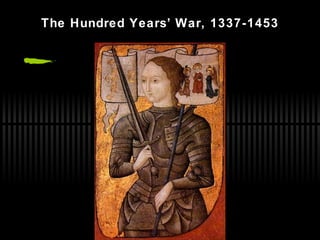
- 1. The Hundred Years’ War, 1337-1453
- 6. Map 1: 1337 How did England get that territory in France in the first place? Why is the compass tilted? In 1337, English had Bordeaux and Guyenne. France had everything else except for Calais. How did they conquer the land in the first place? Why are the two areas the English owned so far away from each other? Why is Calais so much smaller?
- 7. Map 2: 1360 After the Battle of Poitiers, the English gained more ground in France. France gained more land in the HRE. England took over the Channel Islands. There were battles in Poitiers & Crecy. How do you pronounce that city? What happened to Southampton? Where were those battles in those locations? Why did the French move east into the HRE? England gained land and power. There were two battles: Poitiers and Crecy. Why did England gain so much land in France? Who won both those battles? How did England gain control of Crecy?
- 9. Map 4: 1453 The English Channel separated the English territories from the French. How did Burgundy become part of France? Duchy of Burgundy became involved in the war and eventually sided with the French. What areas were held under French rule in 1453? All of France as we know it today. England? They lost all their land on the continent.
Notas del editor
- Image from Historical Stock Photos website: http://www.historicalstockphotos.com/images/xsmall/996_joan_of_arc.jpg
- Break class into four groups. Each group will look at a different map (p. 393). They will list as much info and as many questions as they can for their map. Then share their information with the class the next day. Use Gale Resource Center or Power Library for research. May also need to use the Internet.
- “ In northern Europe, France barely exists in the early fourteenth century but, by the end of the Hundred Years’ War, France expands to become a huge and dominant player in European affairs.” -- from Instructors’ Reference Manual, p. 191