
Recomendados
Más contenido relacionado
La actualidad más candente
La actualidad más candente (20)
Destacado
Destacado (20)
Similar a Fluvial Geomorphology
Similar a Fluvial Geomorphology (20)
Más de Stuart Kirkham
Más de Stuart Kirkham (20)
Último
Último (20)
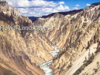
Fluvial Geomorphology
- 2. Overview Fluvial Processes Basel Level Down-cutting and meandering Drainage Watersheds Drainage Patterns Stream flow and fluvial processes Meandering Streams Floodplains Flooding
- 3. Base Level and Fluvial Landscapes A Profound Concept: Water flows downhill Abrades and erodes the landscape as it happens Abrasion = erosion process Creates erosional landforms – drainage patterns, cut banks Carries eroded material downstream as either dissolved, suspended or bed load Load = Transport Load becomes deposited, creating depositional landforms Depositional landforms: Deltas, point bars Base Level: The lowest level that a river can erode down to. Gravity sets the water in motion Ultimately, the water is trying to reach sea level Local impediments to flow create local base levels
- 4. Higher above base level, water has more potential energy, which gets converted to kinetic energy as it flows downslope Above base level, more energy directed downwards, more able to erode bedrock - downcutting Closer to base level, energy directed outward with motion, erosion occurs more laterally - meandering
- 6. Landforms associated with rivers vary by how high above base level the river is Above base level Steep V-shaped valley walls Narrow stream channels Distinct drainage patterns based on underlying geography Downcutting (erosion) and transportation are the main geomorphological forces acting Closer to base level Wide stream channels (floodplains) Valley walls characterized by terracing Meandering river patterns, river deltas lateral abrasion, transport and deposition Tectonic forces can cause areas close to base level to become uplifted Meandering gives way to downcutting Entrenched meanders, canyons
- 11. Drainage When rain falls on a landscape, it drains from higher to lower elevations erodes surfaces as it happens largely an erosional process Occurs above base level - downcutting over time, forms regions of consistent drainage patterns that concentrate runoff into specific streams and rivers watersheds or drainage basins drainage pattern
- 12. Watersheds topography directs flow of surface water into various downslope areas at high points in the topography, surface flow separates down different slopes, and channels water into separate drainage systems these high points are called drainage divides or interfluves drainage divides form the boundaries between watersheds
- 20. Drainage Patterns Pattern relates to underlying bedrock Type of rock Soft sedimentary layers tend to produce dendritic patterns Igneous or hard sedimentary bedrock tends to produce rectangular patterns streamflow directed through orthogonal rock fractures Folding produces trellis patterns
- 21. Dendritic soft underlying sedimentary rock exerts no strong directional influence on the flow of water most common stream pattern a radial pattern occurs when soft layers are uplifted by an igneous intrusion (dome) or on mountain or volcanic peaks
- 24. Trellis Occurs where there is intense folding antiforms and synforms alternating layers of soft and resistant rock Common in Appalachia
- 30. Rectangular Occurs on areas with resistant bedrock Surface flow follows rectilinear fracture pattern of the rock produces an annular pattern when this occurs on a dome
- 31. Parallel Occur on steep slopes Deranged Occur where something has disrupted normal surface patterns and processes, such as glaciation
- 32. Stream Flow and Fluvial Processes Streams run down slopes Potential energy is changed to kinetic energy Discharge Speed Channel depth Channel width Fluvial Processes Erosion: abrasion Transport: load Deposition
- 34. Load Dissolved Load Suspended Load Greatest part Bed Load Traction Saltation General Principle: The greater the speed, the more load a stream can carry Slowing causes deposition Largest and heaviest materials deposited first
- 35. Meandering Streams Erosion and Deposition Undercut bank and point bar
- 37. Floodplain Formation Widening of valley through meandering process Features Floodplain Natural levees Oxbow lakes and swamps Meander scars Terraces
- 48. Entrenched Meanders Landscape was once near base level, and meanders formed. Later, tectonic uplift caused the river to be raised above base level, recommencing down- cutting, and carving these canyons
- 53. Deltas Deposition River reaches sea level (base level) Velocity decreases dramatically Load is deposited Distributaries
- 58. Flooding Rating (10-year flood, 100-year flood, etc) an expression of probability (10%, 1%, resp.) Contributing factors Rainfall, of course Oscillations, hurricanes Human activities that increase runoff and reduce soil moisture storage capacity urbanization (increasing paved surfaces) agricultural practices Midwest Flood of 1993, North Carolina flood of 1999 1000 year flood events (0.1% probability of occurring) Contributed to formations of “Dead Zones” Dead Zone (The Zone of Hypoxia in the Gulf of Mexico) Pamlico Sound, NC