SlideShare una empresa de Scribd logo
1 de 9
International Federation
of Red Cross and Red Crescent Societies


Global Positioning System (GPS)


                Prepared by:         Michael SAFRONOV,
                                     IT/Telecom Officer,
                                     IFRC Geneva
International Federation
       of Red Cross and Red Crescent Societies


       GPS Basics
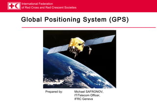
 The 24 satellites that make up the GPS space segment are orbiting the
 Earth about 20,000 km above us. They are constantly moving, making two
 complete orbits in less than 24 hours.
 The location accuracy is anywhere from 1 to 100 meters depending on the
 type of equipment used.
 The GPS is owned and operated by the U.S. Department of Defence, but is
 available for general use around the world.
 GPS works in any weather conditions, anywhere in the world, 24 hours a
 day.
 There are no subscription fees or setup charges to use GPS.
International Federation
        of Red Cross and Red Crescent Societies


        How GPS works (1)

 A GPS receiver needs to know where the satellites are (location), and how
 far they are (distance).

 A GPS satellite is emitting specially modulated signals which pass to GPS
 receiver the needed data:
  Location is determined by “almanac” data, which contains approximate locations of
   satellites, and “ephemeris” data, which is fed from ground control and contains the exact
   location. Ephemeris data takes into account orbit imperfectness and other factors.
  Distance is determined by the GPS receiver by decoding a special timecode in the satellite
   signal, and knowing the speed of radio wave propagation (approx. 300,000 km/h)


 Okay, we know where and how far a satellite is, now what?
International Federation
of Red Cross and Red Crescent Societies


How GPS works (2)
   A calculation method called “trilateration” is used.


                                                           3D trilateration.swf
International Federation
of Red Cross and Red Crescent Societies


Practical use of GPS (1)
             FACT can use GPS for these purposes:
               Mapping
               Navigation
             One of the most used features of a GPS unit is the ability to
             store “waypoints”, or coordinates of locations. For
             example, a field assessment team finds a well in a village,
             which can be used as source of drinking water – the
             coordinates of the well can be memorized in the GPS unit.
             A typical GPS unit (Garmin eTrex Legend pictured) can
             store 1,000 waypoints with unique names.
             Another useful capability is “tracking”, or recording of the
             path you have travelled. This helps to find your way back.
             Waypoints and tracks can then be uploaded to a PC with
             mapping software, and/or sent to Geneva for mapping.
International Federation
  of Red Cross and Red Crescent Societies


  Practical use of GPS (2)

 GPS is not perfectly accurate, measurement errors can be a result of
 several factors:
   Radio signal delays in the atmosphere
   Multi-path reception, when receiver gets the signal directly from satellite, plus a
   reflection of it from a neighbouring mountain or building.
   Receiver clock is not perfect.
   Numbers of satellites “visible” to receiver – generally the more, the better.
   Intentional degradation of satellite signal – GPS is owned by US DoD, so they can
   degrade the precision of satellite signal when and where felt necessary.


 Typically, one can expect GPS accuracy in the range of 3-12 m
 outdoors. Most receivers will not work indoors at all.
International Federation
       of Red Cross and Red Crescent Societies


       Mapping basics (1)
 Earth is not a perfect sphere, it is an ellipsoid. This fact alone can give
 positioning error of hundreds of meters, which is not acceptable in many
 cases.
 In geodesy, a datum is a reference point on surface against which position
 measurements are made, plus an associated model of the shape of the
 Earth.
 Historically, many countries have been developing their own approximations
of Earth’s shape (reference ellipsoid) andthe
  For FACT, we use the WGS84 datum, coordinates grid.
 latest standard of the World Geodetic
 System.
 There are also a few formats of presenting
 the coordinates, we use the classic
 latitude/longitude in degrees, minutes and
 seconds, e.g.:
         E 6°12’59”
         N 46°22’21”
International Federation
       of Red Cross and Red Crescent Societies


       Mapping basics (2)

 Map datum is important when paper maps are used.
 If you’re using the standard WGS84 datum in GPS, and try to map the
 obtained coordinates on a paper map created for a different datum (e.g. US
 NAD83), the error can be few hundred meters!
 Paper maps usually have an indication in which datum they are created.
 Garmin eTrex GPS can be configured for about 100 different datum, if
 needed.
 When sending coordinates to Operations Support Dept. in Geneva, always
 use:
   WGS 84 datum
   Latitude/longitude as Deg°Min’Sec” (e.g. E 6°12’59”/N 46°22’21”)
International Federation
        of Red Cross and Red Crescent Societies


       Mapping basics (3)
 Practical Demonstration of Garmin eTrex Legend and use of MapSource.

Más contenido relacionado

La actualidad más candente

La actualidad más candente (20)

GPS, An Introduction
GPS, An IntroductionGPS, An Introduction
GPS, An Introduction
 
Gps
GpsGps
Gps
 
GPS application soil survey
GPS application soil surveyGPS application soil survey
GPS application soil survey
 
Global positioning system(GPS)
Global positioning system(GPS)Global positioning system(GPS)
Global positioning system(GPS)
 
Project on GPS (Global Positioning System)
Project on GPS (Global Positioning System)Project on GPS (Global Positioning System)
Project on GPS (Global Positioning System)
 
Global positioning system
Global positioning systemGlobal positioning system
Global positioning system
 
gps
gpsgps
gps
 
Gps eser
Gps eserGps eser
Gps eser
 
Global positioning system
Global positioning systemGlobal positioning system
Global positioning system
 
Simply gps tutorial piia
Simply gps tutorial piiaSimply gps tutorial piia
Simply gps tutorial piia
 
Global Positioning System
Global Positioning SystemGlobal Positioning System
Global Positioning System
 
Global Postioning System
Global Postioning SystemGlobal Postioning System
Global Postioning System
 
GPS Surveying
GPS SurveyingGPS Surveying
GPS Surveying
 
Global positioning system_Surveying, Civil Engineering
Global positioning system_Surveying, Civil EngineeringGlobal positioning system_Surveying, Civil Engineering
Global positioning system_Surveying, Civil Engineering
 
The Integration of Geospatial Technologies: GIS and GPS
The Integration of Geospatial Technologies: GIS and GPS	The Integration of Geospatial Technologies: GIS and GPS
The Integration of Geospatial Technologies: GIS and GPS
 
Yarab
YarabYarab
Yarab
 
Global positioning system
Global positioning systemGlobal positioning system
Global positioning system
 
Gps
GpsGps
Gps
 
Gps
GpsGps
Gps
 
Practical Applications of GPS Technology
Practical Applications of GPS TechnologyPractical Applications of GPS Technology
Practical Applications of GPS Technology
 

Destacado

Destacado (11)

T44. satellite communications.ver 2006 11
T44. satellite communications.ver 2006 11T44. satellite communications.ver 2006 11
T44. satellite communications.ver 2006 11
 
Code of conduct (indo)
Code of conduct (indo)Code of conduct (indo)
Code of conduct (indo)
 
Nvis
NvisNvis
Nvis
 
Power pointofsuestubbscrc
Power pointofsuestubbscrcPower pointofsuestubbscrc
Power pointofsuestubbscrc
 
C:\Fakepath\Gps
C:\Fakepath\GpsC:\Fakepath\Gps
C:\Fakepath\Gps
 
Presentation on GPS by Harvendra Singh
Presentation on GPS by Harvendra SinghPresentation on GPS by Harvendra Singh
Presentation on GPS by Harvendra Singh
 
Gps
GpsGps
Gps
 
Global Positioning System (GPS)
Global Positioning System (GPS)Global Positioning System (GPS)
Global Positioning System (GPS)
 
Global positioning System
Global positioning SystemGlobal positioning System
Global positioning System
 
Gps ppt
Gps pptGps ppt
Gps ppt
 
GPS ppt.
GPS ppt. GPS ppt.
GPS ppt.
 

Similar a Gps presentation 2006 10

Similar a Gps presentation 2006 10 (20)

Gps
GpsGps
Gps
 
Gps
GpsGps
Gps
 
GPS.pptx
GPS.pptxGPS.pptx
GPS.pptx
 
Gpa
GpaGpa
Gpa
 
Global Positioning System
Global Positioning System Global Positioning System
Global Positioning System
 
Gps device in the geological field mapping
Gps device in the geological field mappingGps device in the geological field mapping
Gps device in the geological field mapping
 
gps technology
gps technologygps technology
gps technology
 
Global Positioning System (GPS) in Helthcare
Global Positioning System (GPS) in HelthcareGlobal Positioning System (GPS) in Helthcare
Global Positioning System (GPS) in Helthcare
 
Gps systems m. emin özgünsür
Gps systems   m. emin özgünsürGps systems   m. emin özgünsür
Gps systems m. emin özgünsür
 
Global Positioning System
Global Positioning SystemGlobal Positioning System
Global Positioning System
 
Gps
GpsGps
Gps
 
Global Positing System
Global Positing SystemGlobal Positing System
Global Positing System
 
Gps
GpsGps
Gps
 
CE203 -Photogrammetry & GPS.ppt
CE203 -Photogrammetry & GPS.pptCE203 -Photogrammetry & GPS.ppt
CE203 -Photogrammetry & GPS.ppt
 
Global positioning system
Global positioning systemGlobal positioning system
Global positioning system
 
Global Positioning System
Global Positioning SystemGlobal Positioning System
Global Positioning System
 
Application of Satellite
Application of SatelliteApplication of Satellite
Application of Satellite
 
Global positioning system (GPS)
Global positioning system (GPS)Global positioning system (GPS)
Global positioning system (GPS)
 
Electronic Navigations: GPS,GPS terms, GPS use and using Waypoints
Electronic Navigations: GPS,GPS terms, GPS use and using WaypointsElectronic Navigations: GPS,GPS terms, GPS use and using Waypoints
Electronic Navigations: GPS,GPS terms, GPS use and using Waypoints
 
Seminar Report For GPS Technology
Seminar Report For GPS TechnologySeminar Report For GPS Technology
Seminar Report For GPS Technology
 

Más de Zulkarman Syafrin

Más de Zulkarman Syafrin (9)

Single-Area OSPFv2 Concepts.pdf
Single-Area OSPFv2 Concepts.pdfSingle-Area OSPFv2 Concepts.pdf
Single-Area OSPFv2 Concepts.pdf
 
Bazooka dan magnetic loop antenna
Bazooka dan magnetic loop antennaBazooka dan magnetic loop antenna
Bazooka dan magnetic loop antenna
 
Aprs215 instalasi uiss rx-only
Aprs215   instalasi uiss rx-onlyAprs215   instalasi uiss rx-only
Aprs215 instalasi uiss rx-only
 
Hf propagation
Hf propagationHf propagation
Hf propagation
 
W6 cyx kd6ire
W6 cyx kd6ireW6 cyx kd6ire
W6 cyx kd6ire
 
Code of conduct(english)
Code of conduct(english)Code of conduct(english)
Code of conduct(english)
 
Voluntary concept indo
Voluntary concept   indoVoluntary concept   indo
Voluntary concept indo
 
Gerakan & pmi1
Gerakan & pmi1Gerakan & pmi1
Gerakan & pmi1
 
Strategy 2020 presentation
Strategy 2020 presentationStrategy 2020 presentation
Strategy 2020 presentation
 

Último

Mastering MySQL Database Architecture: Deep Dive into MySQL Shell and MySQL R...
Mastering MySQL Database Architecture: Deep Dive into MySQL Shell and MySQL R...Mastering MySQL Database Architecture: Deep Dive into MySQL Shell and MySQL R...
Mastering MySQL Database Architecture: Deep Dive into MySQL Shell and MySQL R...Miguel Araújo
 
Scaling API-first – The story of a global engineering organization
Scaling API-first – The story of a global engineering organizationScaling API-first – The story of a global engineering organization
Scaling API-first – The story of a global engineering organizationRadu Cotescu
 
Apidays New York 2024 - Scaling API-first by Ian Reasor and Radu Cotescu, Adobe
Apidays New York 2024 - Scaling API-first by Ian Reasor and Radu Cotescu, AdobeApidays New York 2024 - Scaling API-first by Ian Reasor and Radu Cotescu, Adobe
Apidays New York 2024 - Scaling API-first by Ian Reasor and Radu Cotescu, Adobeapidays
 
Automating Google Workspace (GWS) & more with Apps Script
Automating Google Workspace (GWS) & more with Apps ScriptAutomating Google Workspace (GWS) & more with Apps Script
Automating Google Workspace (GWS) & more with Apps Scriptwesley chun
 
Workshop - Best of Both Worlds_ Combine KG and Vector search for enhanced R...
Workshop - Best of Both Worlds_ Combine  KG and Vector search for  enhanced R...Workshop - Best of Both Worlds_ Combine  KG and Vector search for  enhanced R...
Workshop - Best of Both Worlds_ Combine KG and Vector search for enhanced R...Neo4j
 
Real Time Object Detection Using Open CV
Real Time Object Detection Using Open CVReal Time Object Detection Using Open CV
Real Time Object Detection Using Open CVKhem
 
How to Troubleshoot Apps for the Modern Connected Worker
How to Troubleshoot Apps for the Modern Connected WorkerHow to Troubleshoot Apps for the Modern Connected Worker
How to Troubleshoot Apps for the Modern Connected WorkerThousandEyes
 
Boost PC performance: How more available memory can improve productivity
Boost PC performance: How more available memory can improve productivityBoost PC performance: How more available memory can improve productivity
Boost PC performance: How more available memory can improve productivityPrincipled Technologies
 
A Domino Admins Adventures (Engage 2024)
A Domino Admins Adventures (Engage 2024)A Domino Admins Adventures (Engage 2024)
A Domino Admins Adventures (Engage 2024)Gabriella Davis
 
GenAI Risks & Security Meetup 01052024.pdf
GenAI Risks & Security Meetup 01052024.pdfGenAI Risks & Security Meetup 01052024.pdf
GenAI Risks & Security Meetup 01052024.pdflior mazor
 
The 7 Things I Know About Cyber Security After 25 Years | April 2024
The 7 Things I Know About Cyber Security After 25 Years | April 2024The 7 Things I Know About Cyber Security After 25 Years | April 2024
The 7 Things I Know About Cyber Security After 25 Years | April 2024Rafal Los
 
Partners Life - Insurer Innovation Award 2024
Partners Life - Insurer Innovation Award 2024Partners Life - Insurer Innovation Award 2024
Partners Life - Insurer Innovation Award 2024The Digital Insurer
 
From Event to Action: Accelerate Your Decision Making with Real-Time Automation
From Event to Action: Accelerate Your Decision Making with Real-Time AutomationFrom Event to Action: Accelerate Your Decision Making with Real-Time Automation
From Event to Action: Accelerate Your Decision Making with Real-Time AutomationSafe Software
 
TrustArc Webinar - Unlock the Power of AI-Driven Data Discovery
TrustArc Webinar - Unlock the Power of AI-Driven Data DiscoveryTrustArc Webinar - Unlock the Power of AI-Driven Data Discovery
TrustArc Webinar - Unlock the Power of AI-Driven Data DiscoveryTrustArc
 
🐬 The future of MySQL is Postgres 🐘
🐬  The future of MySQL is Postgres   🐘🐬  The future of MySQL is Postgres   🐘
🐬 The future of MySQL is Postgres 🐘RTylerCroy
 
TrustArc Webinar - Stay Ahead of US State Data Privacy Law Developments
TrustArc Webinar - Stay Ahead of US State Data Privacy Law DevelopmentsTrustArc Webinar - Stay Ahead of US State Data Privacy Law Developments
TrustArc Webinar - Stay Ahead of US State Data Privacy Law DevelopmentsTrustArc
 
Strategies for Landing an Oracle DBA Job as a Fresher
Strategies for Landing an Oracle DBA Job as a FresherStrategies for Landing an Oracle DBA Job as a Fresher
Strategies for Landing an Oracle DBA Job as a FresherRemote DBA Services
 
Powerful Google developer tools for immediate impact! (2023-24 C)
Powerful Google developer tools for immediate impact! (2023-24 C)Powerful Google developer tools for immediate impact! (2023-24 C)
Powerful Google developer tools for immediate impact! (2023-24 C)wesley chun
 
Axa Assurance Maroc - Insurer Innovation Award 2024
Axa Assurance Maroc - Insurer Innovation Award 2024Axa Assurance Maroc - Insurer Innovation Award 2024
Axa Assurance Maroc - Insurer Innovation Award 2024The Digital Insurer
 
Strategies for Unlocking Knowledge Management in Microsoft 365 in the Copilot...
Strategies for Unlocking Knowledge Management in Microsoft 365 in the Copilot...Strategies for Unlocking Knowledge Management in Microsoft 365 in the Copilot...
Strategies for Unlocking Knowledge Management in Microsoft 365 in the Copilot...Drew Madelung
 

Último (20)

Mastering MySQL Database Architecture: Deep Dive into MySQL Shell and MySQL R...
Mastering MySQL Database Architecture: Deep Dive into MySQL Shell and MySQL R...Mastering MySQL Database Architecture: Deep Dive into MySQL Shell and MySQL R...
Mastering MySQL Database Architecture: Deep Dive into MySQL Shell and MySQL R...
 
Scaling API-first – The story of a global engineering organization
Scaling API-first – The story of a global engineering organizationScaling API-first – The story of a global engineering organization
Scaling API-first – The story of a global engineering organization
 
Apidays New York 2024 - Scaling API-first by Ian Reasor and Radu Cotescu, Adobe
Apidays New York 2024 - Scaling API-first by Ian Reasor and Radu Cotescu, AdobeApidays New York 2024 - Scaling API-first by Ian Reasor and Radu Cotescu, Adobe
Apidays New York 2024 - Scaling API-first by Ian Reasor and Radu Cotescu, Adobe
 
Automating Google Workspace (GWS) & more with Apps Script
Automating Google Workspace (GWS) & more with Apps ScriptAutomating Google Workspace (GWS) & more with Apps Script
Automating Google Workspace (GWS) & more with Apps Script
 
Workshop - Best of Both Worlds_ Combine KG and Vector search for enhanced R...
Workshop - Best of Both Worlds_ Combine  KG and Vector search for  enhanced R...Workshop - Best of Both Worlds_ Combine  KG and Vector search for  enhanced R...
Workshop - Best of Both Worlds_ Combine KG and Vector search for enhanced R...
 
Real Time Object Detection Using Open CV
Real Time Object Detection Using Open CVReal Time Object Detection Using Open CV
Real Time Object Detection Using Open CV
 
How to Troubleshoot Apps for the Modern Connected Worker
How to Troubleshoot Apps for the Modern Connected WorkerHow to Troubleshoot Apps for the Modern Connected Worker
How to Troubleshoot Apps for the Modern Connected Worker
 
Boost PC performance: How more available memory can improve productivity
Boost PC performance: How more available memory can improve productivityBoost PC performance: How more available memory can improve productivity
Boost PC performance: How more available memory can improve productivity
 
A Domino Admins Adventures (Engage 2024)
A Domino Admins Adventures (Engage 2024)A Domino Admins Adventures (Engage 2024)
A Domino Admins Adventures (Engage 2024)
 
GenAI Risks & Security Meetup 01052024.pdf
GenAI Risks & Security Meetup 01052024.pdfGenAI Risks & Security Meetup 01052024.pdf
GenAI Risks & Security Meetup 01052024.pdf
 
The 7 Things I Know About Cyber Security After 25 Years | April 2024
The 7 Things I Know About Cyber Security After 25 Years | April 2024The 7 Things I Know About Cyber Security After 25 Years | April 2024
The 7 Things I Know About Cyber Security After 25 Years | April 2024
 
Partners Life - Insurer Innovation Award 2024
Partners Life - Insurer Innovation Award 2024Partners Life - Insurer Innovation Award 2024
Partners Life - Insurer Innovation Award 2024
 
From Event to Action: Accelerate Your Decision Making with Real-Time Automation
From Event to Action: Accelerate Your Decision Making with Real-Time AutomationFrom Event to Action: Accelerate Your Decision Making with Real-Time Automation
From Event to Action: Accelerate Your Decision Making with Real-Time Automation
 
TrustArc Webinar - Unlock the Power of AI-Driven Data Discovery
TrustArc Webinar - Unlock the Power of AI-Driven Data DiscoveryTrustArc Webinar - Unlock the Power of AI-Driven Data Discovery
TrustArc Webinar - Unlock the Power of AI-Driven Data Discovery
 
🐬 The future of MySQL is Postgres 🐘
🐬  The future of MySQL is Postgres   🐘🐬  The future of MySQL is Postgres   🐘
🐬 The future of MySQL is Postgres 🐘
 
TrustArc Webinar - Stay Ahead of US State Data Privacy Law Developments
TrustArc Webinar - Stay Ahead of US State Data Privacy Law DevelopmentsTrustArc Webinar - Stay Ahead of US State Data Privacy Law Developments
TrustArc Webinar - Stay Ahead of US State Data Privacy Law Developments
 
Strategies for Landing an Oracle DBA Job as a Fresher
Strategies for Landing an Oracle DBA Job as a FresherStrategies for Landing an Oracle DBA Job as a Fresher
Strategies for Landing an Oracle DBA Job as a Fresher
 
Powerful Google developer tools for immediate impact! (2023-24 C)
Powerful Google developer tools for immediate impact! (2023-24 C)Powerful Google developer tools for immediate impact! (2023-24 C)
Powerful Google developer tools for immediate impact! (2023-24 C)
 
Axa Assurance Maroc - Insurer Innovation Award 2024
Axa Assurance Maroc - Insurer Innovation Award 2024Axa Assurance Maroc - Insurer Innovation Award 2024
Axa Assurance Maroc - Insurer Innovation Award 2024
 
Strategies for Unlocking Knowledge Management in Microsoft 365 in the Copilot...
Strategies for Unlocking Knowledge Management in Microsoft 365 in the Copilot...Strategies for Unlocking Knowledge Management in Microsoft 365 in the Copilot...
Strategies for Unlocking Knowledge Management in Microsoft 365 in the Copilot...
 

Gps presentation 2006 10

  • 1. International Federation of Red Cross and Red Crescent Societies Global Positioning System (GPS) Prepared by: Michael SAFRONOV, IT/Telecom Officer, IFRC Geneva
  • 2. International Federation of Red Cross and Red Crescent Societies GPS Basics  The 24 satellites that make up the GPS space segment are orbiting the Earth about 20,000 km above us. They are constantly moving, making two complete orbits in less than 24 hours.  The location accuracy is anywhere from 1 to 100 meters depending on the type of equipment used.  The GPS is owned and operated by the U.S. Department of Defence, but is available for general use around the world.  GPS works in any weather conditions, anywhere in the world, 24 hours a day.  There are no subscription fees or setup charges to use GPS.
  • 3. International Federation of Red Cross and Red Crescent Societies How GPS works (1)  A GPS receiver needs to know where the satellites are (location), and how far they are (distance).  A GPS satellite is emitting specially modulated signals which pass to GPS receiver the needed data: Location is determined by “almanac” data, which contains approximate locations of satellites, and “ephemeris” data, which is fed from ground control and contains the exact location. Ephemeris data takes into account orbit imperfectness and other factors. Distance is determined by the GPS receiver by decoding a special timecode in the satellite signal, and knowing the speed of radio wave propagation (approx. 300,000 km/h)  Okay, we know where and how far a satellite is, now what?
  • 4. International Federation of Red Cross and Red Crescent Societies How GPS works (2)  A calculation method called “trilateration” is used. 3D trilateration.swf
  • 5. International Federation of Red Cross and Red Crescent Societies Practical use of GPS (1)  FACT can use GPS for these purposes:  Mapping  Navigation  One of the most used features of a GPS unit is the ability to store “waypoints”, or coordinates of locations. For example, a field assessment team finds a well in a village, which can be used as source of drinking water – the coordinates of the well can be memorized in the GPS unit.  A typical GPS unit (Garmin eTrex Legend pictured) can store 1,000 waypoints with unique names.  Another useful capability is “tracking”, or recording of the path you have travelled. This helps to find your way back.  Waypoints and tracks can then be uploaded to a PC with mapping software, and/or sent to Geneva for mapping.
  • 6. International Federation of Red Cross and Red Crescent Societies Practical use of GPS (2)  GPS is not perfectly accurate, measurement errors can be a result of several factors:  Radio signal delays in the atmosphere  Multi-path reception, when receiver gets the signal directly from satellite, plus a reflection of it from a neighbouring mountain or building.  Receiver clock is not perfect.  Numbers of satellites “visible” to receiver – generally the more, the better.  Intentional degradation of satellite signal – GPS is owned by US DoD, so they can degrade the precision of satellite signal when and where felt necessary.  Typically, one can expect GPS accuracy in the range of 3-12 m outdoors. Most receivers will not work indoors at all.
  • 7. International Federation of Red Cross and Red Crescent Societies Mapping basics (1)  Earth is not a perfect sphere, it is an ellipsoid. This fact alone can give positioning error of hundreds of meters, which is not acceptable in many cases.  In geodesy, a datum is a reference point on surface against which position measurements are made, plus an associated model of the shape of the Earth.  Historically, many countries have been developing their own approximations of Earth’s shape (reference ellipsoid) andthe For FACT, we use the WGS84 datum, coordinates grid. latest standard of the World Geodetic System.  There are also a few formats of presenting the coordinates, we use the classic latitude/longitude in degrees, minutes and seconds, e.g.: E 6°12’59” N 46°22’21”
  • 8. International Federation of Red Cross and Red Crescent Societies Mapping basics (2)  Map datum is important when paper maps are used.  If you’re using the standard WGS84 datum in GPS, and try to map the obtained coordinates on a paper map created for a different datum (e.g. US NAD83), the error can be few hundred meters!  Paper maps usually have an indication in which datum they are created.  Garmin eTrex GPS can be configured for about 100 different datum, if needed.  When sending coordinates to Operations Support Dept. in Geneva, always use:  WGS 84 datum  Latitude/longitude as Deg°Min’Sec” (e.g. E 6°12’59”/N 46°22’21”)
  • 9. International Federation of Red Cross and Red Crescent Societies Mapping basics (3)  Practical Demonstration of Garmin eTrex Legend and use of MapSource.