SlideShare una empresa de Scribd logo
1 de 4
Descargar para leer sin conexión
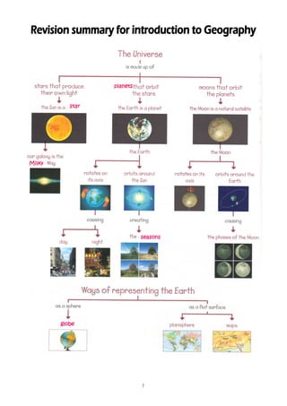
planets


           star


Milky


                            seasons


        globe


                            1
Imaginary lines of latitude and longitude on the Earth
    Imaginary lines are drawn on maps to describe where places are on the Earth.
                               positions
These lines appear in the same positions on all maps

                                       The Earth's axis goes through the centre of
                                       the Earth from the North Pole to the South
                                       Pole. The Earth rotates on this axis

                                       The lines of latitude are parallel circles that
                                       go horizontally around the Earth. They
                                                                  south
                                       indicate distance north or south from the
                                       Equator. The Equator is the middle line that
                                       divides the Earth into two equal parts. These
                                       two parts are Northern Hemisphere and the
                                       Southern Hemispheres

                                       The lines of longitude go vertically from pole to
                                       pole. Every point on Earth is measured iin
                                                                                n
                                       terms of how far east or west it is from the
line of zero longitude. This line is called the Greenwich Meridian because it passes
through Greenwich in England

                        The movements of the Earth
    Celestial bodies move in the sky. For this reason, we know that the Earth and
the Moon move in the sky. This happens even if we cannot feel the movement. The
Earth has two movements, called orbit and rotation.

                                                                              orbit.
    The Earth is a planet which moves around the Sun. This movement is called orbit.
The Earth takes 365 days and 6 hours (one year) to complete one orbit of the Sun.
The amount of light and heat received form the Sun is not equal everywhere on Earth
because of the Earth's tilt. This causes different climates in different areas of the
world. It is also responsible for the changes in season during the year: spring, summer,

                                           2
hemispheres.
autumn and winter. The seasons happen at different times in the two hemispheres.
When it is summer in the Northern Hemisphere, it is winter in the Southern Hemisphere.

                               itself,                        rotation.
     When the Earth rotates on itself, the movement is called rotation. The Earth
takes 24 hours or one entire day, to rotate on itself. This movement causes us to
             night.
have day and night.

    Because the Earth is round, the Sun can illuminate only one area of it. The other
                         the
area of the planet is in the shade. It is day time in the area that the Sun is
illuminating. It is night time in the area that is in the shade. When the Earth rotates,
the area that is illuminated gradually gets darker. The area that is in the shade
gradually gets illuminated.


                         Maps,
                         Maps, scale and projections
    A map is a two dimensional description of a specific area of land. Maps help
geographers understand in a visual way, important things about the surface of the
Earth. They have been used by humans for hundreds of years, but it is impossibility
                                                                      impossibility
of recreating the surface of a round planet on a flat map. Maps are not perfect!


                                           3
Maps can represent a variety of
                                                     information. This information includes things
                                                     such roads, tourist attractions or towns.
                                                     Something can help us understand maps. For
                                                     example, title, legend, scale, geographic
                                                     coordinates or projection. The objects on a
                                                     map are represented using symbols. A symbol
                                                          picture
                                                     is a picture on the map that represents
                                                     something in the real world. To read a map
                                                     you need to understand compass directions
(showing which way is up —North-), grid references (numbered squares), the map's key
                          North-
(the reader knows what the symbols on the map represent) and scale (the reader can
                                                                   (the
translate distances shown on the map into distances on the ground). Make sure
                                                           ground).
         the
you read the title of a map before you start to use it (eg land use or vegetation cover).
This will give you a general idea about the information it stores.

 The scale below is for a 1:50,000 scale       The scale is the proportion between the real size of
 map. At this scale, 1 cm on the map
 represents 50,000 cm on the ground        the represented territory and the corresponding size on
 (= 500 m or 0.5 km)
                                           the map. For example, your map has a scale of 1:25 000,
                                           which means that every 1 cm on the map represents
                                           25000
                                           25000 of those same units of measurement on the
                                           ground (for example, 25000 cm = 250 metres). There
                                                                25000
                                           are three common methods used by map makers to
                                           depict
                                           depict scale: graphic method and fractional method.

                                                                   3-
     A map projection is any of many methods used to represent the 3-dimensional
                          2-
surface of the Earth on a 2-dimensional plane in cartography. There are three map
                                        plane.
projection types: cylindrical, cone and plane.


                                                      4

Más contenido relacionado

La actualidad más candente

La actualidad más candente (20)

Ch 1 Globes and Maps
Ch 1 Globes and MapsCh 1 Globes and Maps
Ch 1 Globes and Maps
 
Maps and globes
Maps and globesMaps and globes
Maps and globes
 
Maps and globes
Maps and globesMaps and globes
Maps and globes
 
Cartography
CartographyCartography
Cartography
 
Maps and globes
Maps and globesMaps and globes
Maps and globes
 
Unit 1.-Earth. Maps
Unit 1.-Earth. MapsUnit 1.-Earth. Maps
Unit 1.-Earth. Maps
 
Unit 1, part 3 the study of geography, cartographers' tools
Unit 1, part 3 the study of geography, cartographers' toolsUnit 1, part 3 the study of geography, cartographers' tools
Unit 1, part 3 the study of geography, cartographers' tools
 
Map and globe skills vocabulary words
Map and globe skills vocabulary wordsMap and globe skills vocabulary words
Map and globe skills vocabulary words
 
Maps and globes
Maps and globesMaps and globes
Maps and globes
 
Cartographic Projections
Cartographic ProjectionsCartographic Projections
Cartographic Projections
 
Reading & interpreting maps notes
Reading & interpreting maps notesReading & interpreting maps notes
Reading & interpreting maps notes
 
Unit 1, part 4, the study of geography, earth
Unit 1, part 4, the study of geography, earthUnit 1, part 4, the study of geography, earth
Unit 1, part 4, the study of geography, earth
 
The geographer’s tools
The geographer’s toolsThe geographer’s tools
The geographer’s tools
 
#2 Maps
#2 Maps#2 Maps
#2 Maps
 
Map Projections
Map ProjectionsMap Projections
Map Projections
 
Glossary unit1
Glossary unit1Glossary unit1
Glossary unit1
 
The celestial sphere
The celestial sphereThe celestial sphere
The celestial sphere
 
The earth
The earthThe earth
The earth
 
Unit1.Planet Earth
Unit1.Planet EarthUnit1.Planet Earth
Unit1.Planet Earth
 
Unit 1Planet Earth
Unit 1Planet EarthUnit 1Planet Earth
Unit 1Planet Earth
 

Destacado

María Antonieta por Sonia Boluda
María Antonieta por Sonia BoludaMaría Antonieta por Sonia Boluda
María Antonieta por Sonia Boludamar76
 
Unidades de relieve de Extremadura
Unidades de relieve de ExtremaduraUnidades de relieve de Extremadura
Unidades de relieve de ExtremaduraIsaac Buzo
 
Descolonización (4ºESO)
Descolonización (4ºESO)Descolonización (4ºESO)
Descolonización (4ºESO)Geohistoria23
 
4ºESO EXÁMENES HISTORIA Curso 2013-2014
4ºESO EXÁMENES HISTORIA Curso 2013-20144ºESO EXÁMENES HISTORIA Curso 2013-2014
4ºESO EXÁMENES HISTORIA Curso 2013-2014Geohistoria23
 
El mundo dividido 1945 1990
El mundo dividido 1945 1990El mundo dividido 1945 1990
El mundo dividido 1945 1990Geohistoria23
 
Guerra fría 2ª parte,aspectos del deporte,ciencia,cultura
Guerra fría 2ª parte,aspectos del deporte,ciencia,cultura Guerra fría 2ª parte,aspectos del deporte,ciencia,cultura
Guerra fría 2ª parte,aspectos del deporte,ciencia,cultura Geohistoria23
 
4ºESO Conflicto Israel-Palestina
4ºESO Conflicto Israel-Palestina4ºESO Conflicto Israel-Palestina
4ºESO Conflicto Israel-PalestinaGeohistoria23
 
4ºESO Guerra de Corea
4ºESO Guerra de Corea4ºESO Guerra de Corea
4ºESO Guerra de CoreaGeohistoria23
 
4ºESO Problemas actuales de la mujer
4ºESO Problemas actuales de la mujer4ºESO Problemas actuales de la mujer
4ºESO Problemas actuales de la mujerGeohistoria23
 
La Península Ibérica en la Edad Media (I): Al- Ándalus
La Península Ibérica en la Edad  Media (I): Al- ÁndalusLa Península Ibérica en la Edad  Media (I): Al- Ándalus
La Península Ibérica en la Edad Media (I): Al- Ándalusartesonado
 
4ºESO Us navy seals
4ºESO Us navy seals 4ºESO Us navy seals
4ºESO Us navy seals Geohistoria23
 
4ºESO Niños soldado
4ºESO Niños soldado4ºESO Niños soldado
4ºESO Niños soldadoGeohistoria23
 
TEMA 8 LA PRIMERA GUERRA MUNDIAL
TEMA 8 LA PRIMERA GUERRA MUNDIALTEMA 8 LA PRIMERA GUERRA MUNDIAL
TEMA 8 LA PRIMERA GUERRA MUNDIALpiraarnedo
 
4ºESO Conflicto Rusia-Ucrania
4ºESO Conflicto Rusia-Ucrania4ºESO Conflicto Rusia-Ucrania
4ºESO Conflicto Rusia-UcraniaGeohistoria23
 
4ºESO La primavera árabe
4ºESO La primavera árabe4ºESO La primavera árabe
4ºESO La primavera árabeGeohistoria23
 

Destacado (20)

Medio fisico de la tierra
Medio fisico de la tierraMedio fisico de la tierra
Medio fisico de la tierra
 
María Antonieta por Sonia Boluda
María Antonieta por Sonia BoludaMaría Antonieta por Sonia Boluda
María Antonieta por Sonia Boluda
 
Extremadura - Geografía 3º ESO
Extremadura - Geografía 3º ESOExtremadura - Geografía 3º ESO
Extremadura - Geografía 3º ESO
 
Extremadura
ExtremaduraExtremadura
Extremadura
 
Unidades de relieve de Extremadura
Unidades de relieve de ExtremaduraUnidades de relieve de Extremadura
Unidades de relieve de Extremadura
 
Descolonización (4ºESO)
Descolonización (4ºESO)Descolonización (4ºESO)
Descolonización (4ºESO)
 
4ºESO EXÁMENES HISTORIA Curso 2013-2014
4ºESO EXÁMENES HISTORIA Curso 2013-20144ºESO EXÁMENES HISTORIA Curso 2013-2014
4ºESO EXÁMENES HISTORIA Curso 2013-2014
 
El mundo dividido 1945 1990
El mundo dividido 1945 1990El mundo dividido 1945 1990
El mundo dividido 1945 1990
 
Guerra fría 2ª parte,aspectos del deporte,ciencia,cultura
Guerra fría 2ª parte,aspectos del deporte,ciencia,cultura Guerra fría 2ª parte,aspectos del deporte,ciencia,cultura
Guerra fría 2ª parte,aspectos del deporte,ciencia,cultura
 
4ºESO Conflicto Israel-Palestina
4ºESO Conflicto Israel-Palestina4ºESO Conflicto Israel-Palestina
4ºESO Conflicto Israel-Palestina
 
4ºESO Guerra de Corea
4ºESO Guerra de Corea4ºESO Guerra de Corea
4ºESO Guerra de Corea
 
4ºESO Problemas actuales de la mujer
4ºESO Problemas actuales de la mujer4ºESO Problemas actuales de la mujer
4ºESO Problemas actuales de la mujer
 
4ºESO México DF
4ºESO México DF4ºESO México DF
4ºESO México DF
 
La Península Ibérica en la Edad Media (I): Al- Ándalus
La Península Ibérica en la Edad  Media (I): Al- ÁndalusLa Península Ibérica en la Edad  Media (I): Al- Ándalus
La Península Ibérica en la Edad Media (I): Al- Ándalus
 
4ºESO Us navy seals
4ºESO Us navy seals 4ºESO Us navy seals
4ºESO Us navy seals
 
4ºESO Niños soldado
4ºESO Niños soldado4ºESO Niños soldado
4ºESO Niños soldado
 
Arte romanico
Arte romanicoArte romanico
Arte romanico
 
TEMA 8 LA PRIMERA GUERRA MUNDIAL
TEMA 8 LA PRIMERA GUERRA MUNDIALTEMA 8 LA PRIMERA GUERRA MUNDIAL
TEMA 8 LA PRIMERA GUERRA MUNDIAL
 
4ºESO Conflicto Rusia-Ucrania
4ºESO Conflicto Rusia-Ucrania4ºESO Conflicto Rusia-Ucrania
4ºESO Conflicto Rusia-Ucrania
 
4ºESO La primavera árabe
4ºESO La primavera árabe4ºESO La primavera árabe
4ºESO La primavera árabe
 

Similar a Revision Summary 00 GEO

Reading & interpreting maps notes
Reading & interpreting maps notesReading & interpreting maps notes
Reading & interpreting maps notescareycannon
 
Motions of the earth
Motions of the earthMotions of the earth
Motions of the earththemassmaker
 
Maps And Globes Are Models Of The Earth
Maps And Globes Are Models Of The EarthMaps And Globes Are Models Of The Earth
Maps And Globes Are Models Of The Earthmrmartella
 
Practical work in geography
Practical work in geographyPractical work in geography
Practical work in geographyShivam Kapri
 
Map projection Map and Globe
Map projection Map and GlobeMap projection Map and Globe
Map projection Map and GlobeKaluramChouhan
 
Cartography Unit_ 3.pptx
Cartography Unit_ 3.pptxCartography Unit_ 3.pptx
Cartography Unit_ 3.pptxwarkisafile1
 
MAP PROJECTION.pdf
MAP PROJECTION.pdfMAP PROJECTION.pdf
MAP PROJECTION.pdfraziaramzan1
 
Types of maps, long, lat, satellites, time zones
Types of maps, long, lat, satellites, time zonesTypes of maps, long, lat, satellites, time zones
Types of maps, long, lat, satellites, time zonesBantay's Earth Science!
 
BOLTSS - Mapping Geography
BOLTSS - Mapping GeographyBOLTSS - Mapping Geography
BOLTSS - Mapping GeographyYaryalitsa
 
Meaning of Globe, Maps, Hemisphere, Prime Meridian, Longitude, Latitude
Meaning of Globe, Maps, Hemisphere, Prime Meridian, Longitude, LatitudeMeaning of Globe, Maps, Hemisphere, Prime Meridian, Longitude, Latitude
Meaning of Globe, Maps, Hemisphere, Prime Meridian, Longitude, Latitudealibangojrjoel
 
Rotation map globe sketch
Rotation  map globe sketchRotation  map globe sketch
Rotation map globe sketchGeeta Bhandari
 
5 themes and map skills
5 themes and map skills 5 themes and map skills
5 themes and map skills Úcar Marian
 

Similar a Revision Summary 00 GEO (20)

Reading & interpreting maps notes
Reading & interpreting maps notesReading & interpreting maps notes
Reading & interpreting maps notes
 
Unit1 160131210057
Unit1 160131210057Unit1 160131210057
Unit1 160131210057
 
Motions of the earth
Motions of the earthMotions of the earth
Motions of the earth
 
Geography
GeographyGeography
Geography
 
Maps And Globes Are Models Of The Earth
Maps And Globes Are Models Of The EarthMaps And Globes Are Models Of The Earth
Maps And Globes Are Models Of The Earth
 
Unit 1 wiki
Unit 1 wikiUnit 1 wiki
Unit 1 wiki
 
Geography.
Geography.Geography.
Geography.
 
Practical work in geography
Practical work in geographyPractical work in geography
Practical work in geography
 
Map projection Map and Globe
Map projection Map and GlobeMap projection Map and Globe
Map projection Map and Globe
 
Map projection
Map projection Map projection
Map projection
 
Cartography Unit_ 3.pptx
Cartography Unit_ 3.pptxCartography Unit_ 3.pptx
Cartography Unit_ 3.pptx
 
MAP PROJECTION.pdf
MAP PROJECTION.pdfMAP PROJECTION.pdf
MAP PROJECTION.pdf
 
Reading a map
Reading a mapReading a map
Reading a map
 
Types of maps, long, lat, satellites, time zones
Types of maps, long, lat, satellites, time zonesTypes of maps, long, lat, satellites, time zones
Types of maps, long, lat, satellites, time zones
 
Lab two
Lab twoLab two
Lab two
 
BOLTSS - Mapping Geography
BOLTSS - Mapping GeographyBOLTSS - Mapping Geography
BOLTSS - Mapping Geography
 
Unit 1.
Unit 1.Unit 1.
Unit 1.
 
Meaning of Globe, Maps, Hemisphere, Prime Meridian, Longitude, Latitude
Meaning of Globe, Maps, Hemisphere, Prime Meridian, Longitude, LatitudeMeaning of Globe, Maps, Hemisphere, Prime Meridian, Longitude, Latitude
Meaning of Globe, Maps, Hemisphere, Prime Meridian, Longitude, Latitude
 
Rotation map globe sketch
Rotation  map globe sketchRotation  map globe sketch
Rotation map globe sketch
 
5 themes and map skills
5 themes and map skills 5 themes and map skills
5 themes and map skills
 

Último

4.16.24 21st Century Movements for Black Lives.pptx
4.16.24 21st Century Movements for Black Lives.pptx4.16.24 21st Century Movements for Black Lives.pptx
4.16.24 21st Century Movements for Black Lives.pptxmary850239
 
Barangay Council for the Protection of Children (BCPC) Orientation.pptx
Barangay Council for the Protection of Children (BCPC) Orientation.pptxBarangay Council for the Protection of Children (BCPC) Orientation.pptx
Barangay Council for the Protection of Children (BCPC) Orientation.pptxCarlos105
 
Virtual-Orientation-on-the-Administration-of-NATG12-NATG6-and-ELLNA.pdf
Virtual-Orientation-on-the-Administration-of-NATG12-NATG6-and-ELLNA.pdfVirtual-Orientation-on-the-Administration-of-NATG12-NATG6-and-ELLNA.pdf
Virtual-Orientation-on-the-Administration-of-NATG12-NATG6-and-ELLNA.pdfErwinPantujan2
 
AMERICAN LANGUAGE HUB_Level2_Student'sBook_Answerkey.pdf
AMERICAN LANGUAGE HUB_Level2_Student'sBook_Answerkey.pdfAMERICAN LANGUAGE HUB_Level2_Student'sBook_Answerkey.pdf
AMERICAN LANGUAGE HUB_Level2_Student'sBook_Answerkey.pdfphamnguyenenglishnb
 
Transaction Management in Database Management System
Transaction Management in Database Management SystemTransaction Management in Database Management System
Transaction Management in Database Management SystemChristalin Nelson
 
USPS® Forced Meter Migration - How to Know if Your Postage Meter Will Soon be...
USPS® Forced Meter Migration - How to Know if Your Postage Meter Will Soon be...USPS® Forced Meter Migration - How to Know if Your Postage Meter Will Soon be...
USPS® Forced Meter Migration - How to Know if Your Postage Meter Will Soon be...Postal Advocate Inc.
 
Choosing the Right CBSE School A Comprehensive Guide for Parents
Choosing the Right CBSE School A Comprehensive Guide for ParentsChoosing the Right CBSE School A Comprehensive Guide for Parents
Choosing the Right CBSE School A Comprehensive Guide for Parentsnavabharathschool99
 
ISYU TUNGKOL SA SEKSWLADIDA (ISSUE ABOUT SEXUALITY
ISYU TUNGKOL SA SEKSWLADIDA (ISSUE ABOUT SEXUALITYISYU TUNGKOL SA SEKSWLADIDA (ISSUE ABOUT SEXUALITY
ISYU TUNGKOL SA SEKSWLADIDA (ISSUE ABOUT SEXUALITYKayeClaireEstoconing
 
AUDIENCE THEORY -CULTIVATION THEORY - GERBNER.pptx
AUDIENCE THEORY -CULTIVATION THEORY -  GERBNER.pptxAUDIENCE THEORY -CULTIVATION THEORY -  GERBNER.pptx
AUDIENCE THEORY -CULTIVATION THEORY - GERBNER.pptxiammrhaywood
 
ECONOMIC CONTEXT - PAPER 1 Q3: NEWSPAPERS.pptx
ECONOMIC CONTEXT - PAPER 1 Q3: NEWSPAPERS.pptxECONOMIC CONTEXT - PAPER 1 Q3: NEWSPAPERS.pptx
ECONOMIC CONTEXT - PAPER 1 Q3: NEWSPAPERS.pptxiammrhaywood
 
Field Attribute Index Feature in Odoo 17
Field Attribute Index Feature in Odoo 17Field Attribute Index Feature in Odoo 17
Field Attribute Index Feature in Odoo 17Celine George
 
HỌC TỐT TIẾNG ANH 11 THEO CHƯƠNG TRÌNH GLOBAL SUCCESS ĐÁP ÁN CHI TIẾT - CẢ NĂ...
HỌC TỐT TIẾNG ANH 11 THEO CHƯƠNG TRÌNH GLOBAL SUCCESS ĐÁP ÁN CHI TIẾT - CẢ NĂ...HỌC TỐT TIẾNG ANH 11 THEO CHƯƠNG TRÌNH GLOBAL SUCCESS ĐÁP ÁN CHI TIẾT - CẢ NĂ...
HỌC TỐT TIẾNG ANH 11 THEO CHƯƠNG TRÌNH GLOBAL SUCCESS ĐÁP ÁN CHI TIẾT - CẢ NĂ...Nguyen Thanh Tu Collection
 
What is Model Inheritance in Odoo 17 ERP
What is Model Inheritance in Odoo 17 ERPWhat is Model Inheritance in Odoo 17 ERP
What is Model Inheritance in Odoo 17 ERPCeline George
 
Judging the Relevance and worth of ideas part 2.pptx
Judging the Relevance  and worth of ideas part 2.pptxJudging the Relevance  and worth of ideas part 2.pptx
Judging the Relevance and worth of ideas part 2.pptxSherlyMaeNeri
 
Procuring digital preservation CAN be quick and painless with our new dynamic...
Procuring digital preservation CAN be quick and painless with our new dynamic...Procuring digital preservation CAN be quick and painless with our new dynamic...
Procuring digital preservation CAN be quick and painless with our new dynamic...Jisc
 
Culture Uniformity or Diversity IN SOCIOLOGY.pptx
Culture Uniformity or Diversity IN SOCIOLOGY.pptxCulture Uniformity or Diversity IN SOCIOLOGY.pptx
Culture Uniformity or Diversity IN SOCIOLOGY.pptxPoojaSen20
 
Grade 9 Quarter 4 Dll Grade 9 Quarter 4 DLL.pdf
Grade 9 Quarter 4 Dll Grade 9 Quarter 4 DLL.pdfGrade 9 Quarter 4 Dll Grade 9 Quarter 4 DLL.pdf
Grade 9 Quarter 4 Dll Grade 9 Quarter 4 DLL.pdfJemuel Francisco
 
Karra SKD Conference Presentation Revised.pptx
Karra SKD Conference Presentation Revised.pptxKarra SKD Conference Presentation Revised.pptx
Karra SKD Conference Presentation Revised.pptxAshokKarra1
 
Keynote by Prof. Wurzer at Nordex about IP-design
Keynote by Prof. Wurzer at Nordex about IP-designKeynote by Prof. Wurzer at Nordex about IP-design
Keynote by Prof. Wurzer at Nordex about IP-designMIPLM
 

Último (20)

4.16.24 21st Century Movements for Black Lives.pptx
4.16.24 21st Century Movements for Black Lives.pptx4.16.24 21st Century Movements for Black Lives.pptx
4.16.24 21st Century Movements for Black Lives.pptx
 
Barangay Council for the Protection of Children (BCPC) Orientation.pptx
Barangay Council for the Protection of Children (BCPC) Orientation.pptxBarangay Council for the Protection of Children (BCPC) Orientation.pptx
Barangay Council for the Protection of Children (BCPC) Orientation.pptx
 
Virtual-Orientation-on-the-Administration-of-NATG12-NATG6-and-ELLNA.pdf
Virtual-Orientation-on-the-Administration-of-NATG12-NATG6-and-ELLNA.pdfVirtual-Orientation-on-the-Administration-of-NATG12-NATG6-and-ELLNA.pdf
Virtual-Orientation-on-the-Administration-of-NATG12-NATG6-and-ELLNA.pdf
 
AMERICAN LANGUAGE HUB_Level2_Student'sBook_Answerkey.pdf
AMERICAN LANGUAGE HUB_Level2_Student'sBook_Answerkey.pdfAMERICAN LANGUAGE HUB_Level2_Student'sBook_Answerkey.pdf
AMERICAN LANGUAGE HUB_Level2_Student'sBook_Answerkey.pdf
 
Transaction Management in Database Management System
Transaction Management in Database Management SystemTransaction Management in Database Management System
Transaction Management in Database Management System
 
USPS® Forced Meter Migration - How to Know if Your Postage Meter Will Soon be...
USPS® Forced Meter Migration - How to Know if Your Postage Meter Will Soon be...USPS® Forced Meter Migration - How to Know if Your Postage Meter Will Soon be...
USPS® Forced Meter Migration - How to Know if Your Postage Meter Will Soon be...
 
Choosing the Right CBSE School A Comprehensive Guide for Parents
Choosing the Right CBSE School A Comprehensive Guide for ParentsChoosing the Right CBSE School A Comprehensive Guide for Parents
Choosing the Right CBSE School A Comprehensive Guide for Parents
 
ISYU TUNGKOL SA SEKSWLADIDA (ISSUE ABOUT SEXUALITY
ISYU TUNGKOL SA SEKSWLADIDA (ISSUE ABOUT SEXUALITYISYU TUNGKOL SA SEKSWLADIDA (ISSUE ABOUT SEXUALITY
ISYU TUNGKOL SA SEKSWLADIDA (ISSUE ABOUT SEXUALITY
 
AUDIENCE THEORY -CULTIVATION THEORY - GERBNER.pptx
AUDIENCE THEORY -CULTIVATION THEORY -  GERBNER.pptxAUDIENCE THEORY -CULTIVATION THEORY -  GERBNER.pptx
AUDIENCE THEORY -CULTIVATION THEORY - GERBNER.pptx
 
YOUVE GOT EMAIL_FINALS_EL_DORADO_2024.pptx
YOUVE GOT EMAIL_FINALS_EL_DORADO_2024.pptxYOUVE GOT EMAIL_FINALS_EL_DORADO_2024.pptx
YOUVE GOT EMAIL_FINALS_EL_DORADO_2024.pptx
 
ECONOMIC CONTEXT - PAPER 1 Q3: NEWSPAPERS.pptx
ECONOMIC CONTEXT - PAPER 1 Q3: NEWSPAPERS.pptxECONOMIC CONTEXT - PAPER 1 Q3: NEWSPAPERS.pptx
ECONOMIC CONTEXT - PAPER 1 Q3: NEWSPAPERS.pptx
 
Field Attribute Index Feature in Odoo 17
Field Attribute Index Feature in Odoo 17Field Attribute Index Feature in Odoo 17
Field Attribute Index Feature in Odoo 17
 
HỌC TỐT TIẾNG ANH 11 THEO CHƯƠNG TRÌNH GLOBAL SUCCESS ĐÁP ÁN CHI TIẾT - CẢ NĂ...
HỌC TỐT TIẾNG ANH 11 THEO CHƯƠNG TRÌNH GLOBAL SUCCESS ĐÁP ÁN CHI TIẾT - CẢ NĂ...HỌC TỐT TIẾNG ANH 11 THEO CHƯƠNG TRÌNH GLOBAL SUCCESS ĐÁP ÁN CHI TIẾT - CẢ NĂ...
HỌC TỐT TIẾNG ANH 11 THEO CHƯƠNG TRÌNH GLOBAL SUCCESS ĐÁP ÁN CHI TIẾT - CẢ NĂ...
 
What is Model Inheritance in Odoo 17 ERP
What is Model Inheritance in Odoo 17 ERPWhat is Model Inheritance in Odoo 17 ERP
What is Model Inheritance in Odoo 17 ERP
 
Judging the Relevance and worth of ideas part 2.pptx
Judging the Relevance  and worth of ideas part 2.pptxJudging the Relevance  and worth of ideas part 2.pptx
Judging the Relevance and worth of ideas part 2.pptx
 
Procuring digital preservation CAN be quick and painless with our new dynamic...
Procuring digital preservation CAN be quick and painless with our new dynamic...Procuring digital preservation CAN be quick and painless with our new dynamic...
Procuring digital preservation CAN be quick and painless with our new dynamic...
 
Culture Uniformity or Diversity IN SOCIOLOGY.pptx
Culture Uniformity or Diversity IN SOCIOLOGY.pptxCulture Uniformity or Diversity IN SOCIOLOGY.pptx
Culture Uniformity or Diversity IN SOCIOLOGY.pptx
 
Grade 9 Quarter 4 Dll Grade 9 Quarter 4 DLL.pdf
Grade 9 Quarter 4 Dll Grade 9 Quarter 4 DLL.pdfGrade 9 Quarter 4 Dll Grade 9 Quarter 4 DLL.pdf
Grade 9 Quarter 4 Dll Grade 9 Quarter 4 DLL.pdf
 
Karra SKD Conference Presentation Revised.pptx
Karra SKD Conference Presentation Revised.pptxKarra SKD Conference Presentation Revised.pptx
Karra SKD Conference Presentation Revised.pptx
 
Keynote by Prof. Wurzer at Nordex about IP-design
Keynote by Prof. Wurzer at Nordex about IP-designKeynote by Prof. Wurzer at Nordex about IP-design
Keynote by Prof. Wurzer at Nordex about IP-design
 

Revision Summary 00 GEO

  • 1. planets star Milky seasons globe 1
  • 2. Imaginary lines of latitude and longitude on the Earth Imaginary lines are drawn on maps to describe where places are on the Earth. positions These lines appear in the same positions on all maps The Earth's axis goes through the centre of the Earth from the North Pole to the South Pole. The Earth rotates on this axis The lines of latitude are parallel circles that go horizontally around the Earth. They south indicate distance north or south from the Equator. The Equator is the middle line that divides the Earth into two equal parts. These two parts are Northern Hemisphere and the Southern Hemispheres The lines of longitude go vertically from pole to pole. Every point on Earth is measured iin n terms of how far east or west it is from the line of zero longitude. This line is called the Greenwich Meridian because it passes through Greenwich in England The movements of the Earth Celestial bodies move in the sky. For this reason, we know that the Earth and the Moon move in the sky. This happens even if we cannot feel the movement. The Earth has two movements, called orbit and rotation. orbit. The Earth is a planet which moves around the Sun. This movement is called orbit. The Earth takes 365 days and 6 hours (one year) to complete one orbit of the Sun. The amount of light and heat received form the Sun is not equal everywhere on Earth because of the Earth's tilt. This causes different climates in different areas of the world. It is also responsible for the changes in season during the year: spring, summer, 2
  • 3. hemispheres. autumn and winter. The seasons happen at different times in the two hemispheres. When it is summer in the Northern Hemisphere, it is winter in the Southern Hemisphere. itself, rotation. When the Earth rotates on itself, the movement is called rotation. The Earth takes 24 hours or one entire day, to rotate on itself. This movement causes us to night. have day and night. Because the Earth is round, the Sun can illuminate only one area of it. The other the area of the planet is in the shade. It is day time in the area that the Sun is illuminating. It is night time in the area that is in the shade. When the Earth rotates, the area that is illuminated gradually gets darker. The area that is in the shade gradually gets illuminated. Maps, Maps, scale and projections A map is a two dimensional description of a specific area of land. Maps help geographers understand in a visual way, important things about the surface of the Earth. They have been used by humans for hundreds of years, but it is impossibility impossibility of recreating the surface of a round planet on a flat map. Maps are not perfect! 3
  • 4. Maps can represent a variety of information. This information includes things such roads, tourist attractions or towns. Something can help us understand maps. For example, title, legend, scale, geographic coordinates or projection. The objects on a map are represented using symbols. A symbol picture is a picture on the map that represents something in the real world. To read a map you need to understand compass directions (showing which way is up —North-), grid references (numbered squares), the map's key North- (the reader knows what the symbols on the map represent) and scale (the reader can (the translate distances shown on the map into distances on the ground). Make sure ground). the you read the title of a map before you start to use it (eg land use or vegetation cover). This will give you a general idea about the information it stores. The scale below is for a 1:50,000 scale The scale is the proportion between the real size of map. At this scale, 1 cm on the map represents 50,000 cm on the ground the represented territory and the corresponding size on (= 500 m or 0.5 km) the map. For example, your map has a scale of 1:25 000, which means that every 1 cm on the map represents 25000 25000 of those same units of measurement on the ground (for example, 25000 cm = 250 metres). There 25000 are three common methods used by map makers to depict depict scale: graphic method and fractional method. 3- A map projection is any of many methods used to represent the 3-dimensional 2- surface of the Earth on a 2-dimensional plane in cartography. There are three map plane. projection types: cylindrical, cone and plane. 4