Story Map Protocol for GeoCapabilties
•
1 like•1,211 views

Story Map Protocol for GeoCapabilties

Recommended
Recommended
More Related Content
More from GeoBlogs
More from GeoBlogs (20)
Recently uploaded
Recently uploaded (20)
Story Map Protocol for GeoCapabilties
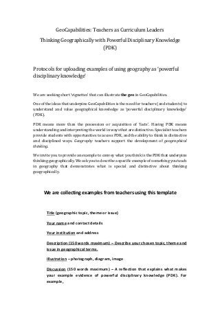
- 1. GeoCapabilities: Teachers as Curriculum Leaders Thinking Geographically with Powerful Disciplinary Knowledge (PDK) Protocols for uploading examples of using geography as ‘powerful disciplinary knowledge’ We are seeking short ‘vignettes’ that can illustrate the geo in GeoCapabilities. One of the ideas that underpins GeoCapabilities is the need for teachers (and students) to understand and value geographical knowledge as ‘powerful disciplinary knowledge’ (PDK). PDK means more than the possession or acquisition of ‘facts’. Having PDK means understanding and interpreting the world in ways that are distinctive. Specialist teachers provide students with opportunities to access PDK, and the ability to think in distinctive and disciplined ways. Geography teachers support the development of geographical thinking. We invite you to provide an example to convey what you think is the PDK that underpins thinking geographically. We askyou to describe a specific example of something you teach in geography that demonstrates what is special and distinctive about thinking geographically. We are collecting examples from teachers using this template Title (geographic topic, theme or issue) Your name and contact details Your institution and address Description (150 words maximum) – Describe your chosen topic, theme and issue in geographical terms. Illustration – photograph, diagram, image Discussion (150 words maximum) – A reflection that explains what makes your example evidence of powerful disciplinary knowledge (PDK). For example,
- 2. • What is geographically theoretical or conceptual about the example? • How does the example support geographical thinking in a way that is systematic (i.e., has value for interpreting the example in a way that expresses the intellectual significance of geographical and spatial concepts such as location, place, region, pattern, spatial hierarchy, regional identity, etc.) We have included some contrasting examples to get you started 1. ‘Boulder Clay’ An example from physical geography 2. ‘Conservation’ An example from conservation
- 3. Example 1 TOPIC Boulder clay and coastal geomorphology NAME Richard Bustin (rbustin@gmail.com) INSTITUTION/LOCATION City of London Freemen’s School, London UK DESCRIPTION My Year 10 class (15 year olds) know that ‘the Holderness coastline (on the east coast of England) is made from boulder clay’. This is not everyday knowledge. But is it ‘powerful knowledge’? I would argue it is not, on its own, powerful knowledge. It is just a more or less correct ‘fact’. However, ‘boulder clay’ (or more precisely glacial till) could be conceptualised in a number of ways by different academic disciplines - chemists would be interested in its chemical composition, physicists might look at its tensile strength and the way it behaves under different stress and pressures. Geographers could look at it in a number of ways, but they are distinctive. For example, geomorphologists would develop their knowledge of boulder clay in terms of its physical properties of permeability, its tendency to slump and move under gravity and how it affects (and is affected by) its environmental context. To fully understand boulder clay geographically it needs to be placed within the context of its origins (from glacial deposition some 10-20,000 years ago) and its surroundings, which in the case of the clay on the Holderness coastline includes its location next to the sea. The actions of the sea (which also can be conceptualised in a number of ways) are of importance to understand the significance of the boulder clay as the wave action undercuts the clay cliffs to cause rapid cliff retreat.
- 4. DISCUSSION Our knowledge of ‘boulder clay’ (or glacial till) is shaped by the way it is conceptualised in the discipline of geography. For instance, we do not fully comprehend the significance of this phenomenon without knowledge of its origins, composition and location. It is this that makes it ‘powerful’. It is almost the ‘back story’ of boulder clay - the way boulder clay is understood - that is indicative of the way geographers identify and describe it, and its significance.
- 5. Example 2 TOPIC Conservation areas and National Parks NAME Duncan Hawley INSTITUTION Geographical Association, 160 Solly Street, Sheffield S1 4BF DESCRIPTION Teaching about conservation areas and National Parks features strongly in my geography teaching. It is easy to teach ‘factual’ information in these topics, especially if taught by using a series of case studies of the sort illustrated in text books. However, I have asked myself what ‘PDK’ was key to understanding certain questions: For example, (i) why some types of environment need special protection, and (ii) how particular types of environment have come to be. Furthermore, I am interested in how students might be helped to consider certain ideas: For example, (i) the value of environments, (ii) the conflicting demands on environments and (iii) the possible implications of changing and managing environments. GeoCapabilities helps in thinking these questions through. Thus, we can think about how the key geographical ideas that may be helpful to students. If we deconstruct the idea of environmental conservation from a geographical perspective we can soon arrive at the following statements: 1. Different places have individual (unique) characteristics. 2. Some environments are consideredvaluable to people (for different reasons), and sometimes in ways that are hard to measure. 3. Places can be altered by people's activities 4. Some types of places can be easily created and some types of place cannot be easily re-created once destroyed or altered. 5. Some valuable places might need special protection to slow down change or reduce to levels that are acceptable or where ‘natural recovery’ occurs. 6. People who are directly affected by the special protection of an environment are often involved in the creation of alternative lifestyles, or at least new ways of thinking about the protected environment. These are all ‘geographical’ perspectives. They represent generalisations that are not necessarily self-evident or obvious. And yet they are helpful to underpin an intelligent conversation about conservation or National Parks.
- 6. DISCUSSION These ideas provide a very useful way of thinking about environments and highlighting conservation from a specifically geographical perspective. The deconstructed (key) ideas in the statements can be reconstructed in several different ways, depending on the particular case being studied or the resources available or selected as most appropriate in the curriculum making process. Using their geographical understanding students gain the capability to reason critically: for example, to decide whether an environment might be given a designation of being ‘special’ (whether considering a ‘natural’ or urban environment). They can be given the opportunity to argue over alternative scenarios for the management of change in these environments.