
More Related Content
What's hot
What's hot (20)
Similar to Geographic information system
Similar to Geographic information system (20)
More from Md. Yousuf Gazi
More from Md. Yousuf Gazi (20)
Recently uploaded
Recently uploaded (20)
Geographic information system
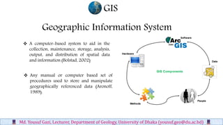
- 1. Geographic Information System A computer-based system to aid in the collection, maintenance, storage, analysis, output, and distribution of spatial data and information (Bolstad, 2002) GIS Md. Yousuf Gazi, Lecturer, Department of Geology, University of Dhaka (yousuf.geo@du.ac.bd) Any manual or computer based set of procedures used to store and manipulate geographically referenced data (Aronoff, 1989).
- 2. Md. Yousuf Gazi, Lecturer, Department of Geology, University of Dhaka (yousuf.geo@du.ac.bd) • It is a Tool, a science, a software and a marriage between computer cartography and database management. • It can tell you what is where and why? • It can model change over time. A container of maps in digital form. A computerized tool for solving geographic problems. A spatial decision support system. . GIS
- 3. GIS Md. Yousuf Gazi, Lecturer, Department of Geology, University of Dhaka (yousuf.geo@du.ac.bd) Computer Aided Cartography (CAC) Remote Sensing (RS) Computer Aided Design/ Drafting (CAD) Database Management Systems (DBMS) GIS Integrated Technologies
- 4. GIS Md. Yousuf Gazi, Lecturer, Department of Geology, University of Dhaka (yousuf.geo@du.ac.bd) Risk assessment • Natural disasters, disease infection, etc. Transportation systems • Highways and interstates, subway and bus routes Infrastructure • Power grids, sewage, water and gas lines Natural resource management Resources inventory (what is available at where?) Network Analysis (How to get to a place in the shortest amount of time?) Location Analysis (Where is the best place to locate a shopping mall?) Terrain Analysis (What is the danger zone for a natural disaster? Visibility analysis) Spatio-Temporal Analysis (Land use: what has changed over the last twenty years, and why?)
- 5. GIS Md. Yousuf Gazi, Lecturer, Department of Geology, University of Dhaka (yousuf.geo@du.ac.bd) Risk assessment Flood Hazard Map of North-Eastern Part of Bangladesh (Gazi et al. 2018)
- 6. GIS Md. Yousuf Gazi, Lecturer, Department of Geology, University of Dhaka (yousuf.geo@du.ac.bd) Transportation systems Emergency referral transport system for suspected sepsis patients in Bangladesh (Chowdhury et al. 2018)
- 7. GIS Md. Yousuf Gazi, Lecturer, Department of Geology, University of Dhaka (yousuf.geo@du.ac.bd) Main pipe network of the water supply in Dhaka city Source: Survey of Bangladesh (sob) Infrastructure
- 8. GIS Md. Yousuf Gazi, Lecturer, Department of Geology, University of Dhaka (yousuf.geo@du.ac.bd) Future development of natural resources and high-value wildlife habitats in boreal landscapes in a area near to northeast British Columbia, Canada (Suzuki and Parker, 2016) Natural resource management
- 9. GIS Md. Yousuf Gazi, Lecturer, Department of Geology, University of Dhaka (yousuf.geo@du.ac.bd)