1. EXPLORATION PLAN FOR THE PINZáN
MORADO PROJECT, GUERRERO, MEXICO.
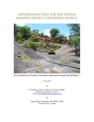
View of the Río Placeres Formation, a metamorphic complex that hosts orogenic lode gold deposits.
21 July 2013
by
M. Robinson, MASc., P.Eng Lic. # 23559, APEGBC
Exploraciones Cigma S.A. de C.V.
E-mail: ing.michellerobinson@gmail.com
for
Cigma Metals Corporation, OTC-PINK: CGMX
Vancouver, B.C., Canada
4. 4
1.0 SUMMARY
The Pinzán Morado Property overlaps an area of 91,559.4 hectares and is centered at 100º 55’ W
and 18º 17’ in northern Guerrero State in the Municipios of Coyuca de Catalán and Zirándaro east
of Cuidad Altamirano (Fig. 4.1; 1:50 000 INEGI map sheets E14-A73, E14-A74, E14-A83,
E14A84). Three mining concessions that define the Property (Table 4.1) are 100% owned by
Exploraciones Cigma S.A. de C.V., a 100% owned subsidiary of Cigma Metals Corporation. In
August of 2012, Exploraciones Cigma purchased 100% of the concessions from Exploraciones
La Plata, the Mexican subsidiary of Alphamin Resources Corp., subject to a 1.5% NSR.
The Property overlaps part of a major porphyry system associated with a Tertiary diorite intrusion
hosted in sedimentary rocks of the Zihuatenejo subterrane of the Guerrero Composite Terrane.
Field inspections of this area imply that this system that includes iron-copper skarns at La Cruz,
stratabound iron-copper replacement bodies in turbidites of the Lower San Lucas Formation at La
Colorada, conventional stockwork style porphyry copper mineralization in the diorite west of La
Cruz, and distal lead and zinc dominant veins at La Reyna and La Esmeralda. Collectively, this
geochemically zoned system defines an area 27 km in length and 11 km in width. These
dimensions compare well to better studied porphyry systems from other parts of the world (e.g.
Fig. 8.4).
Exploraciones Cigma should focus on finding and developing the copper and molybdenum rich
core to the porphyry system. The tools best suited to the task include: (i) a high-resolution
helicopter borne magnetic survey, (ii) a grid-based geological, geochemical and alteration survey,
(iii) possible IP/resistivity surveys of selected targets, (iv) topographic surveying for ground
control and (v) exploration drilling (either coring or RC drilling). The ground and airborne
surveys define the Phase 1 program with a budget of $830 000 USD. Phase 2 is drill-testing of
targets defined in Phase 1, and a Budget of about 1.0 million USD is proposed. These budgets
are just large enough to meet the legal minimum maintenance requirements of the Property for
2013 and 2014.
2.0 INTRODUCTION
This Report is prepared for Cigma Metals Corporation at the request of the shareholders. The
purpose of the Report is to analyse the information available on the Pinzán Morado Project and
draft an exploration strategy that will maximize the value of the Project to its stakeholders.
Sources of data include:
Geological maps, stream sediment geochemical data and magnetic data by the Servicio
Geologico Mexicano, purchased by Exploraciones Cigma.
Geological/Mining reports by the Servicio Geologico Mexicano.
A geological report and maps of the Bajarique prospect (Griffith, 2001).
A new map of the Project area by Martini et al. (2009).
Stream sediment and rock geochemical data from the previous owner, Exploraciones La
Plata.
Rock geochemical data from Anglo American
The author of this Report inspected several concessions internal to the Aurora concessions in
2004 as part of a regional exploration program for iron-oxide copper gold deposits for Anglo
American. She also supervised the collection of the stream sediment samples for Exploraciones
La Plata.
5. 5
3.0 RELIANCE ON OTHER EXPERTS
None.
4.0 PROPERTY DESCRIPTION AND LOCATION
The Property is centered at 100º 55’ W and 18º 17’ in northern Guerrero State. Three mining
concessions that define the Property (Table 4.1) are 100% owned by Exploraciones Cigma S.A.
de C.V., a 100% owned subsidiary of Cigma Metals Corporation. In August of 2012,
Exploraciones Cigma purchased 100% of the concessions from Exploraciones La Plata, the
Mexican subsidiary of Alphamin Resources Corp., subject to a 1.5% NSR.
The Project overlaps an area of 91,559.3931 hectares. It is centered in northern Guerrero State in
the municipios of Coyuca de Catalán and Zirándaro east of Cuidad Altamirano near geographic
co-ordinates 100º 55’ W and 18º 17’ (Fig. 4.1; 1:50 000 INEGI map sheets E14-A73, E14-A74,
E14-A83, E14A84). The concessions (Table 4.1) are located using legally surveyed monuments
in UTM co-ordinates, NAD27 datum. All mining monuments must have minimum dimensions of
0.6*0.6*1.0 metres, show the name of the concession, the surface area in the concession
application, the office where the concession is registered, and the file number. Several
concessions may be located on a single monument. Concession boundaries are located using
polar co-ordinates relative to the monument, and are not marked or surveyed in the field.
All of the concessions remain valid for 50 years from the date of title as long as bi-annual mining
duties are paid in July and January of every year (Table 4.2), and minimum annual investment
requirements are met (Table 4.3). After 50 years, the concession owner may apply for a second
50 year term. Investments made in excess of the annual minimum may be carried forward into
the following year. Expenditures that meet the investment requirements are (Ley Minera, 1992):
I. Direct mining works, such as ditches, wells, slashes, tunnels and all others that
contribute to geological knowledge of the mining claim or the mining reserves;
II. Drilling;
III. Topographic, photogrammetric and geodesic surveys;
IV. Geological, geophysical and geochemical surveys;
V. Physical-chemical analysis;
VI. Metallurgical experimentation tests;
VII. Development and rehabilitation of mining works;
VIII. Acquisition, lease and maintenance of drilling equipment and development of mining
works;
IX. Acquisition, lease and maintenance of equipment for physical-chemical laboratories
and metallurgical research;
X. Acquisition, lease and maintenance of work vehicles and for personnel
transportation;
XI. Works and equipment used for job safety and the prevention of pollution or
restoration of the environment;
XII. Facilities for warehouses, offices, workshops, camp sites, dwellings and services to
workers;
XIII. Acquisition, lease, construction and maintenance of works and equipment related to
access roads, generation and conduction of electric energy, extraction, conduction
and storage of water and infrastructure in general;
XIV. Acquisition, lease and maintenance of equipment for mining, hauling and general
services in the mine, and
XV. Acquisition, lease, installation and maintenance of equipment for beneficiation
operations and tailings dams.
Non-payment of mining duties or not investing in a mining concession are both causes for
cancellation of the concession. However, the obligation to invest can be temporarily suspended
6. 6
for up to three consecutive years in a 10 year period for technical, economic, labor or judicial
reasons or a force majeure event (Ley Minera, 1992). To suspend the obligation to invest, it is
required to file supporting documentary evidence attached to the annual investment report.
Table 4.1 List of concessions owned by Exploraciones Cigma S.A. de C.V., a wholly-owned subsidiary
of Cigma Metals Corporation. A 1.5% NSR royalty is payable to Exploraciones La Plata, S.A. de
C.V., a subsidiary of Alphamin Resources Corp.
Concession Title Number File Number Title Date Surface area in Ha.
Aurora II 235480 033/09795 04-Dec-09 1,946.6488
Aurora 238662 033/09787 11-Oct-11 89,558.6322
Aurora Fraccion I 238663 033/09787 11-Oct-11 54.1121
TOTAL (Ha) 91,559.3931
Table 4.2 Estimated Mining Duties for 2013-2015. Based on Rates for 2013 (MXN Pesos). The
conversion from MXN to USD is based on a rate of 12.114 MXN per USD.
Concession Jan-Jun 2013 Jul-Dec 2013 Jan-Jun 2014 Jul-Dec 2014 Jan-Jun 2015 Jul-Dec 2015
Aurora II $ 16,585 $ 16,585 $ 16,585 $ 34,300 $ 34,300 $ 34,300
Aurora $ 763,040 $ 763,040 $ 763,040 $ 763,040 $ 1,578,023 $ 1,578,023
Aurora Fraccion I $ 308 $ 308 $ 308 $ 461 $ 461 $ 461
TOTAL (MXN) $ 779,933 $ 779,933 $ 779,933 $ 797,801 $ 1,612,784 $ 1,612,784
TOTAL (USD) $ 64,383 $ 64,383 $ 64,383 $ 65,858 $ 133,134 $ 133,134
Table 4.3 Estimated minimum annual investment requirements for 2013-2017 (MXN Pesos). Based
on rates published in December of 2012 for 2013. The conversion from MXN to USD is based on a
rate of 12.114 MXN per USD.
Concession 2013 2014 2015 2016 2017
Aurora II $ 241,524 $ 519,175 $ 519,175 $ 2,057,008 $ 2,057,008
Aurora $ 10,635,111 $ 10,635,111 $ 10,635,111 $ 23,802,021 $ 23,802,021
Aurora Fraccion I $ 5,298 $ 5,298 $ 5,298 $ 7,674 $ 7,674
TOTAL (MXN) $ 10,881,933 $ 11,159,584 $ 11,159,584 $ 25,866,702 $ 25,866,702
TOTAL (USD) $ 898,294 $ 921,214 $ 921,214 $ 2,135,273 $ 2,135,273
Since 2011, the Company has not raised enough funds to meet the minimum investment
requirements for the Property. Mining Law does allow Property owners to not invest for three
consecutive years when economic conditions are poor. In 2015, the Company must invest fully
in all of its concessions, or lose the unworked Property. This report recommends geological
mapping, geophysics and diamond drilling to meet the investment requirements. Road building
and exploration drilling now require filing of the "Informe Preventivo”, a report that states the
measures that will be used by the Company to minimize environmental impacts and filing of the
“Cambio Justificado Uso de Suelo”. Successful filing of this report usually involves the payment
of fees to the Forestry Department for timber-cutting rights along proposed access routes. The
Company has not filed any documents for the planned exploration work.
Surface rights to the land underlying the Project concessions are owned by several Ejidos and
individuals. Ejidos are rural farming and ranching communities. Decisions regarding Ejido land,
including those allowing mining investment on their property, are usually made at monthly
meetings. Written authorizations of all surface landowners to be affected by the exploration are
appended in any Reports filed with SEMARNAT, along with the legal descriptions and location
plans of their properties. At this time, the Company does not know the location of all landowners
in the concession area.
The law does give priority to mining concession owners, and they have the right to obtain the
expropriation, temporary occupancy or creation of land easement needed to carry out exploration
7. 7
and exploitation work, as well as for the deposit of rock dumps, tailings and slag (Ley Minera,
1992).
Fig. 4.1 Map showing the location of the Pinzán Morado Project in northwestern Guerrero State,
Mexico. GREEN = State of Guerrero, RED = Highway, BLUE = Company Property, GREY = third
party owned property, BLUE STARS = State Capitals, MAGENTA STARS = producing mines.
8. 8
Fig. 4.2 Map of the Pinzán Morado Project concessions showing roads and mine workings (PICKS).
GREY = property owned by third party. NAVY = Company property. DASHED LINES = roads.
BLACK DOT = historic drill hole. BLUE DOT = town or village. YELLOW = Municipio of Coyuca
de Catalán, PEACH = Municipio of Zirándaro
5.0 Accessibility, Climate, Local Resources,
Infrastucture and Physiography
The Project is located about 200 kilometers southwest of Mexico City, and immediately west of
Cuidad Altamirano, a small city with a population of 25,168 according to the 2010 INEGI census.
This is down from a peak of 25,317 in 2005. Access to the Project is via a network of country
roads (Fig. 4.2).
The Property overlaps the southern side of the Balsas Depression. The Río Balsas, one of the
largest rivers in Mexico, trends westerly and traverses the northern margin of the Property.
Elevations range from 180 m in the bottom of the valley in the northwestern corner of the
Property to 1300 m at the top of Cerro El Chiquhuitero in the southeastern quadrant of the
Property. Other important rivers include the Río del Oro on the westerly side of the Property, and
the Arroyo Chamaqua on the southeastern part of the Property. Both drainages trend northerly
into the Río Balsas. There is a major dam where the Río Balsas and Río del Oro intersect called
Presa la Calera. Other important mountains include Cerro La Peña Blanca (1180 m) 2 km north
of Puerto del Oro and Cerro Las Parotas (1000 m) in the northeastern part of the Property.
This is a hot, arid region (locally described as Tierra Caliente) with temperatures ranging from
18ºC in January to over 47ºC in the summer at mid-day. Mean annual temperature is 26.9ºC.
The rainy season occurs between May and September. Mean annual rainfall is 952 mm.
9. 9
Natural vegetation is mainly classified as “tropical dry forest” (selva baja caducifolia). Tropical
dry forest is characterized by deciduous trees less than 15 m high that conserve water by shedding
their leaves in the dry season. The newly bare trees open up the canopy layer, enabling sunlight
to reach ground level and facilitate the growth of thick underbrush. Trees typical of tropical dry
forest areas include mezquite, cueramo, huizache, cutaz, cahuina, cuirindal, cacamicua, parota,
tepeguaje, ceiba, tepemesquite, palma and cascalote. Columnar, cholla and barrel cactus also
occur. Trees on moister sites and those with access to ground water tend to be evergreen.
Tropical dry forests are also home to a variety of small animals including deer, foxes, skunks,
armadillos, hares, tejones, coyotes, eagles, crows, gavilan, guacamayas, parrots, iguanas and
snakes.
Agricultural production is the most important economic activity, and consists mostly of basic
staple crops such as corn and beans along with tomatoes, tomatillos, okra, green chili peppers,
chickpeas, yams, and other vegetables. A number of fruits are grown for both domestic
consumption and market such as melons, papaya, watermelon, mangos, bananas, tamarind and
citrus. Livestock includes cattle, pigs, goats and sheep as well as some domestic fowl. However,
due to the lack of formal employment, many citizens, especially the men, have gone to the United
States to work.
6.0 HISTORY
The Balsas River valley is the birthplace of metallurgy in the Americas. The Tarascos, people
native to the Project area, gave the river known as Placeres de Oro its original name of Tiripit
Yurecua, which means river of gold.
Little is known about the Spanish mining history. However, abandoned piles of magnetite slag
mark historic smelter sites at Piedra Imán and Cerro del Chivo that probably belonged to the
Spanish.
Mining activity in Pinzán Morado was inititated 1840 by a priest. As the known mines of the
Pinzán Morado orogenic gold district are not on the Property, the history of this area is detailed in
Section 13.1.
During the 1950’s about 6400 tonnes of hand-sorted copper ore was produced from the El Sauz
vein and the Chiromo manto. The vein ore was shipped to a smelter in San Luis Potosi and the
manto ore shipped to a small leach plant in Coyuca de Catalán.
7.0 GEOLOGICAL SETTING AND
MINERALIZATION
7.1 REGIONAL GEOLOGICAL SETTING
The Property overlaps part of the Zihuatanejo subterrane of the Guerrero Composite Terrane
(GCT) to the east, and part of the Cenozoic volcanic belt to the west. The GCT is a complex
assemblage of mostly submarine volcanic and volcaniclastic rocks of Jurassic to Cretaceous age
built on the Arteaga Schist, an older metamorphic complex. The GCT is the largest of all the
Mexican Terranes, and probably the second largest of the North American Cordillera after
Wrangellia (Centeno-Garcia et al., 2008). The GCT is composed of several sub-terranes: Tahue,
Zihuatanejo, Arcelia, Guanajuato and Teloloapan (Fig. 7.1). Relationships between the sub-
terranes of the GCT are not known everywhere as most of the GCT is buried under large volumes
of Cenozoic volcanic rocks.
Centeno-Garcia et al. (2011) also divide the GCT into four distinct tectonostratigraphic
assemblages (i) a Triassic-Early Jurassic accretionary complex (Arteaga Schist), (ii) a Jurassic to
earliest Cretaceous extensional volcanic arc assemblage (e.g. Cuale Volcanic Sequence), (iii) an
Early Cretaceous extensional arc assemblage; and (iv) a Santonian-Maastrichtian compressional
arc assemblage. Of these, (i) and (iii) occur on the Property.
10. 10
Fig. 7.1 Map of the Guerrero Composite Terrane (from Centeno-Garcia et al., 2011).
7.2 PROPERTY GEOLOGY
Geological maps of the Property area were published by the Servicio Geologico Mexicano in
2002 (E14A74, E14A75, E14A84, E14A85). In 2009, Martini et al. published a major update to
the geology. Figure 7.2, a geological map of the Property, is derived by the author of this Report
from both sources of data, with a bias towards the more recent data of Martini et al. (2009).
7.2.1 RÍO PLACERES FORMATION.
The Río Placeres Formation is a metamorphic complex exposed north and west of Pinzán Morado
over an area about 10 km long and 300 to 3000 m wide. It consists of gray to violet slates and
phyllites, alternating with quartz-rich meta-sandstone and black recrystallized limestone. The
lithologic assemblage is characteristic of deep-marine turbidites. Sandstones and phyllites have
developed a foliated fabric shown by elongated quartz ribbons with white micas and tremolite-
actinolite amphiboles along surfaces parallel to bedding planes. The Río Placeres Formation is
correlated to the late Triassic Arteaga Metamorphic Complex in Michoacan, about 150 km to the
west (Centeno-Garcia et al, 2008; Martini et al, 2009). In the Project area, the western margin of
the Rio Placeres Formation is faulted against Tertiary volcanic rocks, and the eastern boundary is
intruded by the Placeres de Oro pluton. Other contacts with younger rocks are unconformable.
7.2.2 SAN LUCAS FORMATION
San Lucas Formation is Valanginian to Aptian in age (138-113 Ma), outcrops in the northeastern
part of the Property and is divided into two members: (i) the lower Terrero Prieto member and the
upper Las Fraguas member. Lower Terrero Prieto member is 800 m to 1900 m thick (thickening
to the north), and consists of 2 to 30 cm thick interbeds beds of mudstone, shale and sandstone.
The lithology and fossils are characteristic of pelagic deposits in an open marine environment
11. 11
(Martini et al., 2009). Upper Las Fraguas member is 100 to 1200 m thick (thickening to the
south) and composed of thick feldspathic sandstone with lesser amounts of brown to green
mudstone and conglomerate. Lithologic and faunal associations suggest deposition in a distal
deltaic fan environment (Martini et al., 2009).
7.2.3 COMBURINDIO FORMATION
The Comburindio Formation conformably overlies the San Lucas Formation, is up to 1100 m
thick, and ranges from Barremian to Aptian (124-113 Ma) in age. It mainly outcrops in the
southeastern part of the Property south of Coyuca de Catalán. The Formation is composed of a
thick sequence of quartz-feldspathic sandstone, volcaniclastic and calcareous conglomerate, and
lesser amounts of shale. Biostromic limestone banks occur in the upper part of the sequence.
The dominant reddish colour of the clastic parts of the sequence suggests prolonged subaerial
exposure. The limestones bear abundant fauna, including rudists, corals ammonites and
nerineids. They form outstanding morphologic rims that make them easy to distinguish from
surrounding clastic rocks (Martini et al., 2009).
7.2.4 EL CAJON FORMATION
El Cajon Formation is up to 700 m thick, entirely Aptian in age (119-113 Ma) and conformably
overlies both the San Lucas and the Comburindio Formations. It consists of sandy limestone,
coquina of orbitolinids, bioclastic limestone with corals, rudists and gastropods and massive
limestone with shale at the top of the succession (Martini et al., 2009).
7.2.5 PLACERES DEL ORO PLUTON
The Placeres del Oro pluton outcrops in the central part of the project area, trends northerly, and
is about 21 km long and 7 km wide. It cuts the lower San Lucas Formation and is overlain
unconformably by Eocene lavas and ignimbrites. The pluton consists of medium to coarsely
crystalline quartz diorite that is mainly composed of plagioclase, quartz, K-feldspar, hornblende,
biotite and oxides. The average result of several U-Pb age determinations for zircons from the
pluton is 120.2 +/- 2.1 Ma (Martini et al., 2009). Samples of dated using Ar40
/Ar39
age
determinations biotite and hornblende yielded a result of 115-116 Ma for crystallization of those
minerals. Together, the data imply a cooling history for the pluton of about 5 million years.
7.2.6 MAL PASO FORMATION
Mal Paso Formation is up to 1000 m thick, conformably overlies the El Cajon Formation, and
ranges in age from Early Albian to Early Cenomanian (113-97 Ma). It is divided into two
members, (i) a lower deltaic clastic member and (ii) an upper limestone reef and lagoonal
member. The lower member consists of a sequence of medium to thick bedded quartzo-
feldspathic and lithic sandstone and massive polymictic conglomerate, mostly composed of
cobbles and boulders of limestone. Toward the top, the sequences grade into medium-bedded red
claystone, siltstone and sandstone and an interbedded biostromic bank with abundant Toucasia.
Fossil wood and logs also occur. The reef and lagoonal member consists of calcareous quartzo-
feldspathic, medium-bedded grey sandstone and some intercalations of siltstone, claystone and
limestone. Toward the top, the sandstones gradually change to marl and thin-bedded argillaceous
limestone with abundant corals, gastropods, echinoids, ammonites, bivalves and biostromic
rudists (Martini et al., 2009).
7.2.7 ANDESITIC LAVAS
Andesitic lavas outcrop in the western and the southeastern portion of the Property. This
sequence is composed of about 1500 m of mafic to intermediate lava flows and autoclastic
breccias that discordantly cover the Mesozoic rocks and the Placeres del Oro pluton. The lavas
have porphyritic to megaporphyritic textures. Phenocrysts are mainly plagioclase and hornblende
12. 12
in a matrix of volcanic glass with minor oxides. K/Ar ages are between 46 and 43 Ma for these
rocks (Martini et al., 2009).
7.2.8 DACITIC DOMES
. North of Cuidad Altamirano, on the eastern margin of the Property, there is a dacitic dome on
the order of 10 km in diameter that intrudes the Mesozoic rocks. The dome is porphyritic with
phenocrysts of plagioclase and clinopyroxene in a fine-grained matrix of volcanic glass. Samples
of plagioclase dated using Ar40
/Ar39
methods yielded a result of 43 Ma (Martini et al., 2009)
7.2.9 DIORITE
The largest dioritic intrusion on the Property occurs north of the Placeres de Oro pluton and
outcrops over an area 18 km long and 3 km wide that trends southeasterly. Other outcrops of
diorite occur in the southwestern and southeastern parts of the Property. The diorites are
phaneritic, coarsely to finely crystalline and consist of plagioclase with hornblende, quartz, K-
feldspar, clinopyroxene, biotite and oxides. Results from an Ar40
/Ar39
age determination of
Tertiary diorite from Guayameo (60 km west of the Property) yielded an age of 43 Ma (Martini et
al., 2009). A second sample from a Tertiary pluton near San Jeronimo (80 km northwest of the
Property) yielded an Ar40
/Ar39
age determination of 39.8 +/- 0.6 Ma.
7.2.10 RHYOLITE IGNIMBRITE
Rhyolite ignimbrite is over 1000 m thick and mainly occurs in the western portion of the
Property. It covers the intermediate to mafic lavas and plutonic rocks and rests in angular
unconformity over folded Mesozoic rocks. Crystals in the ignimbrite are broken, and consist of
plagioclase, quartz, hornblende and biotite floating in a pink to white matrix of volcanic ash and
lapilli. Samples of plagioclase dated using Ar40
/Ar39
yielded a result of 37 Ma for the base of the
ignimbrite (Martini et al., 2009).
13. 13
Fig. 7.2 Geological map of the Pinzán Morado Project. PICKS = mine workings. GREY = property
owned by third party. NAVY = Company property. BLACK DOT = historic drill hole. BLUE DOT
= town or village.
14. 14
Fig. 7.3 Black meta-argillite of the Río Placeres
Formation. These rocks are correlated to the
Arteaga Metamorphic Complex. This mine was
worked for gold.
Fig. 7.4 Thinly bedded brown siltstone of the
Terrero Prieto member of the Lower San Lucas
Formation. Photo is from Mina Colorada, a copper
prospect hosted in these rocks.
Fig. 7.5 Green conglomerate in the Las Fraguas
member of the Upper San Lucas Formation.
Roadcut west of Mina Hedionda.
Fig. 7.6 Siliceous quartz-pebble conglomerates in
the Las Fraguas member of the Upper San Lucas
Formation near “La Reyna” post.
Fig. 7.7 Metasomatized limestone (skarn) from the
Comburindio Formation. Sample 25737 contains
>1% Cu, 10.4 g/t Ag, >27% Fe, 1.7 g/t Au and 37
ppm Sn.
Fig. 7.8 Tertiary diorite with oxidized copper
mineralization.
7.3 MINERALIZATION
7.3.1 SANTA TERESA MINERALIZED ZONE
The Santa Teresa mineralized zone is 12.5 km long, up to 3 km wide and trends northwesterly. It
includes several quartz veins with values of silver, copper and gold, including La Blanca,
Minerva, La Esperanza, La Rebelde, Naylei, El Sauz, San Elias Dos, Chihuahua, Santo Tomas,
La Relumbrosa, La Machina and Socorro. El Pitallo and La Niña (on internally held concessions;
Section 13.4) represent the northwestern termination of this zone. Mineralization is hosted in
quartz veins of unknown age that cross-cut the Placeres de Oro Batholith. In 1990, the SGM did
reconnaissance sampling of La Blanca on behalf of its owner. A chip channel sample across the
vein yielded a result of 0.3 g/t Au, 27 g/t Ag and 1.3% Cu across 0.8 m (Huicochea-Guerrero, J.,
Fernandez-Fuente, J., 1990a).
Table 7.1 Characteristics of individual mineral showings of the Zona Mineralizada Santa Teresa
(reported from the SGM database for E14A74).
15. 15
Name Dimensions Mineralogy Metals Grades Type of Working
LA BLANCA L=500 M; W=2.8
M; D=17 M
Galena,
Chalcopyrite
Au, Ag,
Cu
Au=0.61 g/t, Ag=260 g/t,
Pb=0.88 %, Zn= 0.54 %,
Cu=0.60 %
Adit
MINERVA L=8 M; W=4 M;
D=4 M
Malachite, Azurite Cu Cu=0.27-3.25% Trench
LA ESPERANZA L=20 M; W=0.3
M; D=20 M
Galena,
Chalcopyrite,
Pyrite
Ag, Cu Au=0.25-1.50 g/t, Ag=36-8874
g/t, Pb=0.31-2.93 %, Zn=0.11-
0.32%, Cu=0.11-10.27%
Trench
EL SAUZ L=5 M; W=0.25
M; D=ND M
Quartz Cu, Au Au=0.25-0.60 g/t, Ag=13-70 g/t,
Cu=0.23-2.73%
Outcrop
NAYELI L=260 M; W=0.3
M; D=20 M
Malachite,
Azurite, Pyrite
Cu, Au Au=0.25-0.50 g/t, Ag=5-155 g/t,
Cu=0.53-3.70%
Trench
LA REBELDE L=20 M; W=0.4
M; D=8 M
Galena,
Malachite, Azurite
Ag, Cu Ag=204-239 g/t, Cu=0.57-4% Pit
SAN ELIAS DOS L=30 M;
W=0.6O M;
D=20 M
Bornite,
Chalcopyrite,
Pyrite
Cu, Ag,
Au
Au=0.50-0.60 g/t, Ag=48-143
g/t, Cu=1.35-4.45%
Adit
SANTO TOMAS L=10 M; W=1.5
M; D=ND M
Chalcopyrite Cu Au=0.25 g/t, Ag=4-8 g/t,
Cu=0.68-2%
Outcrop
LA
RELUMBROSA
L=40 M; W=1.5
M; D=ND M
Pyrite,
Chalcopyrite
Au Au=0.25-0.50 g/t, Ag=7-24 g/t Adit
LA MACHINA L=50 M; W=30
M; D=ND M
Pyrite,
Chalcopyrite
Au, Cu Outcrop
SOCORRO L=10 M; W=0.3
M; D=ND M
Pyrite,
Chalcopyrite
Au, Cu Au=0.80 g/t, Ag=5-21 g/t,
Cu=0.17-1.02%
Outcrop
CHIHUAHUA L=50 M;
W=0.20-2.0 M;
D=10 M
Malachite, Azurite Cu Cu=4.70-7.35% Adit
ND = Not Determined
7.3.2 LA ESMERALDA, EL CUARTO I, II AND EL CHACAL
La Esmeralda, El Cuarto I, El Cuarto II and El Chacal are sub-epithermal, base-metal rich veins
(e.g. Fig. 8.1) hosted in Tertiary diorite porphyry over an area about 5 km long and 1.5 km across.
La Esmeralda is the largest of these mineral prospects, and is located 9 km northwest of Coyuca
de Catalán.
At Esmeralda, mineralization is hosted in at least 14 east-northeast trending, 0.3 m to 1 m wide
veins that dip vertically to moderately southeast (Gallardo-Melendez and Altamirano, 1979).
Mineralization consists mainly of sphalerite with galena and pyrite in a gangue of quartz, calcite
and barite. In 1979, the Consejo de Recursos de Minerales (now the SGM) mapped and sampled
210 meters of historic horizontal and vertical underground workings. In 1981, the SGM
completed 117 meters of additional tunnels and calculated historic, non NI43-101 compliant
resources for two blocks of mineralization. The larger block was estimated at 382.5 tonnes with
values of 0.75 g/t Au, 22.12 g/t Ag, 0.47% Pb and 5.5% Zn. The smaller block contained 298
tonnes of 1.71 g/t Au, 27.68 g/t Ag, 0.75% Pb and 13.55 % Zn (Gallardo-Melendez and
Hernandez-Gonzalez, 1981). Their report recommended diamond drilling to expand the mineral
resource to depth.
16. 16
A stream sediment sample, taken by Exploraciones La Plata 1200 meters northeast and
downstream of La Esmeralda, returned values of 62.1 ppm Cu, 551.1 ppm Pb, 3097 ppm Zn and
30.5 ppb Au (sample 83078). The tenor of these values is in good agreement with the rock
geochemistry reported by the SGM.
One kilometer to the east, the SGM reports that the El Chacal workings expose a malachite and
sphalerite rich vein ranging from 0.2 to 1 m wide, 20 m long and at least 10 m deep. Two and
three kilometers to the south of Esmeralda, they report that prospects El Cuarto II and El Cuarto I
are of similar dimensions, but consist mainly of pyrite, covellite and malachite. Between El
Chacal and El Cuarto I, three stream sediment samples from Exploraciones La Plata returned
moderately anomalous values for copper and or gold: (i) sample 82869 with 39 ppm Cu and 20.7
ppb Au, sample 83055 with 22 ppb Au and sample 83057 with 38.8 ppm Cu.
7.3.3 MINA VERDE, EL CIRIANCITO, COLMENEROS
Mina Verde, El Ciriancito and Colmeneros are described as vein prospects hosted in the
siliciclastic sediments of the Upper San Lucas Formation, between two intrusions of Tertiary age.
Mina Verde is an adit, and the SGM reports values of 0.2-1 g/t Au, 65-588 g/t Ag and 0.01-1.47%
Cu across 0.85 m. El Ciriancito is also an adit, but no grades are reported. Colmeneros is a
trench with values of 0.2 g/t Au, 7 to 198 g/t Ag and 0.1 to 0.2% Cu across 1.05 m reported by
the SGM.
Rock sample 23568, taken 410 m east of Colmeneros by Exploraciones La Plata, returned values
of 0.13 g/t Au, 11.2 g/t Ag, 140 ppm Mo and 0.3% Cu across 2 m. Similarly, rock sample 23567,
taken 280 m southeast of Colmeneros, returned values of 6.6% Cu and 29.7 g/t Ag across 2 m.
7.3.4 PITIRE, EL ALACRAN, EL RUSO
This group of prospects are also described as veins hosted in the siliciclastic sediments of the
Upper San Lucas Formation, on the northern flank of a Tertiary diorite intrusion. The SGM
reports that El Ruso contains values of 1.2 g/t Au, 33 g/t Ag and 1.67 % Cu exposed in a trench.
El Alacran is an abandoned adit with values of 0.13 g/t Au, 59 g/t Ag and 0.98% Cu. Pitire is a
vein with values of 0.6 to 9.9% Cu across 1.3 m. The showings are in the northern part of a
contiguous stream sediment anomaly for copper that is about 12 km in diameter.
7.3.5 LA MORENA AND JUPITER
La Morena and Jupiter are described as vein prospects, and they occur just south of the large (12
km across) stream sediment anomaly for copper mentioned in the previous section (7.3.4). The
SGM reports values of 0.22 g/t Au, 36 g/t Ag and 2.2 % Cu for La Morena, and 54 g/t Ag and
4.9% Cu for Jupiter.
7.3.6 CERANO
Cerano is described as a vein hosted in the siliciclastic sediments of the Upper San Lucas
Formation, close to an unconformable contact with Tertiary volcanic rocks. The SGM reports
mineralization is oxidized to malachite and azurite with values of 0.22 g/t Au, 0.16% Cu and 6 g/t
Ag. The mineral prospect is peripheral to a stream sediment anomaly for copper defined by 5
contiguous drainage basins over an area 4 km long and about 2 km wide.
7.3.7 LA GLORIA AND PTO. DE CHIRIMO
La Gloria and Pto. de Chirimo are prospects hosted in redbeds of the Mal Paso Formation. The
SGM reports that La Gloria is a vein on the order of 600 m long, 1 m wide and 50 m deep with
values of 0.25 to 5.4 g/t Au, 4 to 90 g/t Ag, and 0.02 to 1.7% Cu exposed by a shaft. Pto. de
Chirimo is a manto exposed by a small adit and has reported grades of 0.2 to 0.5 g/t Au, 26-43 g/t
Ag and 2.7 to 8.0% Cu. The mineral prospects are peripheral to a contiguous two-basin stream
sediment anomaly for copper and gold 2.8 km long and 1 km wide that trends east-west.
17. 17
7.3.8 DON HUICHO
Don Huicho is an isolated gold prospect hosted in Tertiary diorite. The SGM reports values of
0.19 g/t Au to 0.12 g/t Au across 1.1 m.
8.0 DEPOSIT TYPES
8.1 OROGENIC LODE GOLD DEPOSITS
Orogenic lode gold provinces are associated with accretionary orogens (accretion of one or more
allochtonous terranes and oceanic crust to continental margin). Examples include: (i) the Russian
Far East, (ii) Victoria, Australia, (iii) Shandong, China and, (iv) the North American Cordillera.
In these orogens, significant gold deposits are located proximal to major accretionary boundary
structures. They are mostly sited in lower to medium greenschist facies metamorphosed turbiditic
rocks (Bierlein and Crowe, 2000). In the Property area, the Río Placeres Formation hosts several
gold deposits of this type, including the Garduño, Veta Madre, Cigarillo and Pinzán veins
(Section 13.1).
Imaging of gold and other trace elements in pyrite from orogenic gold deposits shows that sulfur,
arsenic and gold is introduced into the sedimentary host rock as syn-genetic and diagenetic gold-
bearing arsenian pyrite, with the sulfur produced by a mixture of both hydrothermal reduction and
bacterial reduction of seawater sulfate (Chang et al., 2010). During metamorphism, gold, arsenic
and iron in the early pyrite is released to the metamorphic fluid, and re-deposited as native gold
with and within coarsely crystalline pyrite, arsenopyrite, and quartz in pressure shadows (fold
noses) and structurally prepared sites (faults). Ore deposition occurs over a temperature range of
150ºC to 450ºC and a depth range between 2 km and 15 km. The hydrothermal fluids are weakly
saline (up to 6 wt% NaCl2), contain up to 50 mole % CO2, and the dominant gold-carriers are
bisulfide complexes (not chloride brines).
Important exploration features of orogenic lode gold deposits are (Bierlein and Crowe, 2000):
The principal ore mineral is native gold that contains less than 10% silver (the gold does
NOT occur in electrum).
Associated ore minerals include arsenopyrite and pyrite. Sometimes trace amounts of
chalcopyrite, galena, sphalerite and stibnite occur, but the total sulfide content is usually
less than 5%. Metal and mineral zoning is not significant.
Gold and associated sulfides occur in quartz that can be associated with carbonate,
feldspar, mica and tourmaline.
The veins occur in high-angle reverse faults (thrusts). These thrusts represent second
order faults and splays which develop in the hangingwall of long-lived translithospheric
structures.
Wall-rock alteration mineral assemblages include phyllic, argillic, propylitic and sodic.
18. 18
Fig. 8.1 Schematic representation of the orogenic lode gold and other gold-deposit forming
environments (from Wilson, 2013). Note the extensive vertical extent of the orogenic system
largely controlled by deep crustal faults which provide fluid conduits for metamorphogenic
fluids.
8.2 PORPHYRY COPPER SYSTEMS
Porphyry copper systems are defined as large volumes (10 to more than 100 km 3
) of
hydrothermally altered rock centered on intrusive stocks that may also contain skarn, carbonate-
replacement, sediment-hosted and high sulfidation epithermal base and precious metal
mineralization (Fig. 8.1; Sillitoe, 2010). In plan view, the long dimension of the economic part of
porphyry deposits ranges from 600 m long for Batu Hiaju, Indonesia, to 6 kilometers long at
Butte, Montana. Bingham Canyon, Utah, is about 1.5 km in diameter, and Bajo de la Alumbrera
in Argentina is about 700 meters in diameter (Seedorff et al. 2005). The majority of the world’s
porphyry systems occur in Tertiary calc-alkaline batholiths and overlying volcanic chains. The
deeper parts of porphyry Cu systems may contain porphyry Cu +/- Mo +/- Au deposits of up to
10 billion tonnes in size. Typical hypogene porphyry copper deposits have average grades of 0.5
to 1.5% Cu, <100 ppm to 400 ppm Mo and trace to 1.5 g/t Au. Other metals including W, Sn, Bi,
Os and Re can also form economic concentrations in porphyry systems.
Porphyry copper systems share the following characteristics (Sillitoe, 2010):
19. 19
The main economic hypogene ore minerals are chalcopyrite, bornite, molybdenite,
sphalerite, galena, native Au and electrum. Associated minerals include pyrite and
magnetite. The minerals and metals are zoned from copper and molybdenum rich centers
to peripheral zinc and lead rich veins and replacement deposits (Figs. 8.2 and 8.4)
Silicate alteration minerals include: quartz, biotite, K-feldspar, actinolite, albite,
tourmaline, dumortorite, muscovite, andalusite, pyrophyllite, alunite, clay minerals,
epidote and chlorite. These are also zones from proximal potassic assemblages to distal
clays (Fig. 8.3)
They are spatially associated with porphyritic intrusions.
Porphyry copper systems are localized by deep, crustal-scale faults which allow for rapid
ascent of magmas and generation of a hydrothermal fluid.
The ore zones of hypogene porphyry copper deposits occur at paleo-depths ranging from
1 to 5 kilometers.
Porphyry copper deposits are overlain by extensive lithocaps that may have an area of up
to 100 km2
on surface. The vertical distance between the lithocap and potassic alteration
related to the porphyry copper deposit ranges from 500 to 1000 meters. The lithocap
itself might be as thick as 1000 meters.
Advanced argillic alteration preferentially occurs in rocks with a low acid-buffering
capacity such as rhyolite tuffs. It is less common in mafic rocks as these tend to
neutralize acidic solutions.
Above the porphyry copper deposit, the lithocap may be enriched in As, Mo, Te, Bi, W,
and Sn.
Fig. 8.2 Essential characteristics of a porphyry copper
system showing a centrally located porphyry Cu +/- Au
+/- Mo deposit in a multiphase porphyry stock and its
immediate host rocks (from Sillitoe, 2010).
Fig. 8.3. Generalized alteration-mineralization zoning
pattern for porphyry copper deposits (from Sillitoe,
2010).
20. 20
Fig 8.4. Examples of well-developed metal zoning centered on porphyry copper systems (from
Sillitoe, 2010). (a) Bingham Utah where the porphyry Cu-Au-Mo deposit is followed successively
outward by Cu-Au skarn, carbonate-replacement Zn-Pb-Ag-Au and distal sediment hosted Au
deposits Barney’s Canyon and Melco. (b) Mineral Park, Arizona where the northwest striking vein
system centered on the porphyry Cu-Mo deposit is zones outward from Cu through Pb-Zn to Au-Ag.
(c) Sepon Laos where two porphyry Cu-Mo centers are zoned outward through carbonate-
replacement Cu to sediment hosted Au deposits.
8.3 EPITHERMAL GOLD DEPOSITS
Epithermal gold deposits comprise veins and disseminations of economic gold concentrations
with or without silver and base metals within 1.5 kilometers of the Earth’s surface. Most form by
open-space filling of faults (vein deposits), but some form by replacement of the host rocks
(disseminated deposits). Most of the known economic epithermal precious metal deposits occur
in Tertiary volcanic rocks, both in compressive arcs and in extensional arc settings. They can
also occur in sedimentary or metamorphic rocks.
Mineable epithermal vein deposits range from 50 000 tonnes to 1, 000, 000 tonnes in size, with
typical grades ranging from 2 to 20 g/t Au, and locally exceptional grades of more than 1000 g/t
Au or “bonanza lodes”. Veins can be several kilometers long, but they are usually mineralized in
segments where dilation has occurred—these are “ore shoots” or “clavos”. In Mexico, the strike
21. 21
length of individual ore shoots ranges from 5 to 300 meters long, widths range from 1 to 10
meters, and they can be as large as 1.2 kilometers down-dip (Enriquez and Rivera, 1998). A
single vein can host multiple ore shoots.
Other important characteristics of epithermal vein deposits include (Hedenquist and White,
2005):
High grades of Au and Ag.
Anomalous concentrations of Sb, As, Hg, Pb, Zn, Cu and other metals.
Ore minerals include native gold, electrum, acanthite, tetrahedrite, silver (Cu, Pb)
sulfosalts, sphalerite, galena, pyrite and chalcopyrite.
Minerals are deposited in open spaces, and have characteristic textures (e.g. colloform
banded and cockscomb textures are typical).
Multiple stages of mineralization may occur in the same vein, with some stages having
different base to precious metal ratios from other stages.
Gangue minerals include quartz, calcite, barite, clay, sericite, chlorite and epidote.
Hypogene kaolinite and dickite are important in the ore shoots. Nontronite, an Fe-
smectite, occurs in some gold-rich ore shoots (Hedenquist, 2009).
Alteration mineral assemblages indicate temperatures of deposition between 100 and
300ºC. Typical alteration types include: (i) proximal propylite, (ii) distal zones of clay
alteration and (iii) unmineralized, but related zones of steam-heated alteration or
“lithocaps”.
Several sub-classes of epithermal deposits are recognized: (i) low sulfidation, (ii) intermediate
sulfidation and (iii) high sulfidation (Hedenquist and White, 2005). Having said that, different
classes of deposit may occur in the same camp, and some styles may overprint earlier styles.
High sulfidation epithermal gold deposits tend to occur in the upper parts of porphyry copper
systems (Figs 8.2, 8.3, 8.5A). Intermediate and low sulfidation deposits are more typical of
extensional tectonic settings.
Fig. 8.5 Genetic models of different types of epithermal precious metal deposits in Mexico. Most
Mexican epithermal precious metal deposits are of type “B” (from Camprubi and Albinson, 2007).
9.0 EXPLORATION
Exploraciones Cigma has not done any exploration. In 2002, the SGM completed geological
mapping and stream sediment sampling of several 1:50 000 mapsheets in Guerrero State,
including E14A74 and E14A84. In 2004, the author of this report completed reconnaissance
traverses of the area as part of a search for Iron-Oxide-Copper-Gold deposits for Anglo
22. 22
American. In 2007, she supervised a brief stream sediment sampling campaign for Exploraciones
La Plata.
9.1 STREAM SEDIMENT GEOCHEMISTRY
In 2007, Exploraciones La Plata collected 233 stream sediment samples, mainly from first and
second order drainages according to the procedures outlined in Section11.1.1. The samples were
analyzed for gold and base metals according the procedures outlines in Section 11.2. Distribution
statistics for the metal concentration data are in Table 9.1. Anomaly thresholds were set close to
the 75th
percentile for copper, and close to the 90th
percentile for gold, zinc and lead. Values were
not anomalous for silver, and only sample has a markedly anomalous molybdenum concentration.
Finally, concentrations of calcium in excess of 3% correlate well to surface outcrops of limestone,
particularly the Mal Paso Formation in the eastern and northern portion of the Property. The
limestones are of interest as they can host iron-copper skarns of potentially economic value.
To fill in gaps where Exploraciones La Plata had sparse data, Exploraciones Cigma purchased
geological and geochemical datasets from the SGM for the E14A74 and E14A84 mapsheets.
After reviewing the data, it was decided that silver and gold measurements were unreliable
(Section 12), but data for copper, lead, zinc, calcium and molybdenum compared well to the
Exploraciones La Plata data, and could be used in this Report.
To quickly identify areas of interest, data for copper, lead, zinc and molybdenum were gridded
and contoured to produce several anomaly maps. The results are summarized on Fig. 9.1. The 40
ppm copper contour defines an area 11 kilometers across centered on the Lorena porphyry
system (Section 13.2). Satellite copper anomalies on the order of 2 km in diameter are located at
El Cerano and east of Mesa de Tecuche. The single point molybdenum anomaly occurs between
La Cruz and El Cerano. Peripheral to copper anomaly, strong anomalies for lead and zinc, both
about 4 km in diameter, are centered on La Esmeralda and north of La Piñuela.
In addition, the catchement areas for anomalous stream sediment values were also drawn. These
define the areas for further surveying better than the gridding method.
Table 9.1 Distribution statistics for 233 stream sediment samples taken by Exploraciones La Plata.
Field Maximum Mean 50th 75th
90th 95th 98th
Ca_% 15 1 1 1 2 3 7
Cu_ppm 715 42 29 41 62 83 211
Mo_ppm 16 1 1 1 2 2 3
Pb_ppm 551 15 10 16 22 25 50
Zn_ppm 3097 87 66 86 116 168 222
Au_ppb 3227 25 1 4 14 31 118
Ag_ppm 1 0 0 0 0 0 0
23. 23
Fig. 9.1 Geochemical anomaly map of the Pinzán Morado Project. PICKS = mine workings. GREY
= property owned by third party. NAVY = Company property. BLACK DOT = historic drill hole.
BROWN SQUARE = town or village, RED=anomalous catchement basin, GREEN LINES = copper
anomalies, MAGENTA LINE = molybdenum anomaly, BROWN LINES = lead + zinc anomalies
BLACK LINES = faults. Note the metal zoning from central copper-rich geochemistry to peripheral
lead and zinc geochemistry.
9.2 AIRBORNE MAGNETIC SURVEY
The SGM flew an airborne magnetic survey over mapsheets F14A74 and F14A84 in 1999. Lines
were oriented north-south and spaced 1km apart with control lines every 10 km at a height of 300
m above land. Further details regarding the equipment used are published in the map legends and
metadata. Their map of the total magnetic field is in Fig. 9.2.
The low under Cerro La Higuera to the north coincides with outcrops of the Cumburindio, El
Cajon and Mal Paso limestones. In the northeastern part of the map area, there is a moderate
amplitude magnetic high associated with Tertiary dacitic domes. A larger, higher amplitude
magnetic high occurs between Socorro and Piñuela. The area is mapped as Placeres del Oro
Batholith and Tertiary rhyolite. However, the linear nature of the anomaly suggests that there
may an unmapped dike swarm oriented parallel to the northwest-trending faults, perhaps of the
same Tertiary dacites that occur in the northeast. The Placeres de Oro Batholith itself does not
appear magnetic. Tertiary diorites related to porphyry copper mineralization inside the >40 ppm
Cu contour (green) do not appear magnetic either, and the magnetic field there is similar to the
surrounding sediments of the San Lucas Formation on this map. However, there is an interesting
magnetic low oriented WNW about 5 km long and 2 km wide in the northern portion of the
internal Lorena concession, outlined in blue. The author of this Report speculates that this
magnetic low might be related to a zone of magnetite-destructive phyllic alteration within the
porphyry system that may or may not be exposed on surface. Finally, a moderate amplitude
magnetic high east of Don Huicho might be an unmapped dacite dome or a buried intrusion.
24. 24
Fig. 9.2 Total field magnetic map of the Pinzán Morado Project. PICKS = mine workings. NAVY =
Company property. BLACK DOT = historic drill hole. BROWN SQUARE = town or village,
GREEN LINES = copper anomalies, MAGENTA LINE = molybdenum anomaly, BROWN LINES =
lead + zinc anomalies BLACK LINES = faults, BLUE LINE = magnetic low in diorite that might
reflect hydrothermal alteration related to a porphyry system.
10.0 DRILLING
The author of this report is not aware of any drilling on the Property. Known targets drilled by
the SGM or other third parties are mainly held on internal or adjacent concessions (Section 13).
11.0 SAMPLE PREPARATION, ANALYSIS AND
SECURITY
11.1 SAMPLE PREPARATION
11.1.1 STREAM SEDIMENT SAMPLES
Stream sediment samples for Exploraciones La Plata were collected from poorly sorted material
in gravel-rich sandbars. Well-sorted sand deposits were avoided. About a kilogram of fines from
gravel deposits was collected in a Tyvek sand sample bag and sealed with a numbered tag. To
avoid contamination: (i) sampling crews were instructed not to wear metal jewelry, (ii) sample
bags were securely tied off at the sample site, and (iii) samples were routinely bagged for
shipping to the lab at the end of the day in rice bags. Stream sediment samples were never
bagged with rock samples to avoid cross-contamination between sample types. No standards or
blanks were inserted into the sample stream.
Sampling procedures for the SGM stream sediment samples are not known to the author.
25. 25
11.1.2 ROCK SAMPLES
Several types of rock samples were used by Exploraciones La Plata in the evaluation of the
Property. These are listed in Table 11.1. For all types of samples, about 2 kilograms of rock
chips were collected in a double-bagged plastic sample bag with a numbered tag. Samplers were
instructed not to wear metal jewelry to avoid sample contamination. No standards or blanks were
inserted into the sample stream.
Table 11.1 Types of rock samples used to evaluate mineral occurrences on the Property.
SAMPLE TYPE DESCRIPTION AND COLLECTION METHOD
Grab Samples A sample taken from an outcrop, but not oriented across a structure, and not necessarily
representative.
Float Samples A rock sample from loose material, usually stream boulders or colluvium.
Dump Samples Material collected from a mine dump. These are not usually representative.
Chip Samples Oriented samples taken across a width by chipping pieces of rock approximately every 10 cm.
Chip-Channel Samples Oriented samples cut across a representative part of a mineralized structure using a sledgehammer and
chisel to form a continuous channel. Most channel samples were cut only after the working face had
been cleared of soil and debris, and the oxidized material removed using a hammer if at all possible.
After cleaning, about 2 kg of rock chips were put into a doubled plastic sample bag and sealed with a
plastic tie. Where possible, chip channel samples were used to evaluate the grade of mineral zones
exposed on surface and underground.
11.2 SAMPLE ANALYSIS AND SECURITY
All samples from Exploraciones La Plata were stored in a secure building at camp, then
backhauled to the office in Mazatlán. Once the program was complete, all samples were shipped
via DHL to Acme Laboratories’ preparation lab in Guadalajara, Jalisco.
Stream sediment samples were dried at 60 degrees Celsius, then screened to –80 mesh. The
screened pulps were shipped via DHL to ACME Laboratories in Vancouver. Fifteen gram pulps
were digested in warm aqua regia for 1 hour, diluted to 300 ml with demineralised water, and
analyzed for gold, silver and base metals using an Inductively Coupled Plasma Mass
Spectrometer (ICP-MS; 1DX package, job GUJ07000003.2).
Rock samples were dried at 60 degrees Celsius, crushed, then split with a riffle splitter. Two
hundred and fifty grams of the split sample was pulverized for analysis. Thirty grams of pulp was
analysed for gold using Group 6 fire assay with ICP-ES finish. One gram of the pulp was
analysed for base metals and silver by digesting it with 50 ml of aqua regia, then diluted it to 100
ml with water. Elements in solution were determined using a combined ICP-ES/ICP-MS analysis
(job GUJ07000002.1).
SGM analytical or security procedures are not known to the author.
12.0 DATA VERIFICATION
Acme Laboratories inserts standard and blank pulps into the sample stream to check for within-
batch analytical precision and accuracy, and to ensure that there was no contamination between
samples. Analytical precision (CVi
) is calculated according to:
CVi
=100*si
/Xi
(%)
where si
is the standard deviation of element i in the samples analysed and Xi
is the sample mean.
Accuracy (Ai
) is estimated according to:
Ai
=100*(Cr
i
-Ca
i
)/Cri
where Cr
i
is the reported value of element i in the reference material, and Ca
i
is the apparent or
analysed proportion of element i in the reference material.
26. 26
Reference materials inserted into the sample stream indicate that analytical precision is about 5%
for Mo, Zn and Ag. For Cu and Pb, it is closer to 7%. For gold, analytical precision is 44%.
Analytical accuracy is on the order of 5% for Ag, Mo, Zn, Ag, Cu and Pb. For gold, it is about
30%. There were no failures on the blank samples that indicated contamination had occurred in
the lab.
As the author of this Report has no access to quality control information for the SGM stream
sediment data, it was decided to compare the distribution statistics of their data to the data for
Exploraciones La Plata (Table 12.1). Inspection of the data shows that the distributions are
similar for Ca, Cu, Mo, Pb and Zn, but that gold and silver values (underlined), distribute much
higher in the SGM data than in Exploraciones La Plata data. Further, comparison of samples
from the same stream beds confirms that gold and silver “anomalies” identified by the SGM do
not occur in Exploraciones La Plata data. Therefore, when generating the anomaly map of
Fig. 9.1, gold and silver values from the SGM data for all mapsheets were excluded as it is
the author’s opinion that they are not reliable.
Table 12.1 Distribution statistics for stream sediment samples from Exploraciones La Plata (blue)
and the Servicio Geologico Mexicano (black) for E14A74.
Field Count_n Maximum Mean 50th 75th 90th 95th 98th
Ca_% 201 17 2 1 2 5 8 12
Ca_% 233 15 1 1 1 2 3 7
Cu_ppm 201 210 33 28 37 47 59 107
Cu_ppm 233 715 42 29 41 62 83 211
Mo_ppm 201 4 1 1 1 1 1 1
Mo_ppm 233 16 1 1 1 2 2 3
Pb_ppm 201 440 17 11 17 29 44 64
Pb_ppm 233 551 15 10 16 22 25 50
Zn_ppm 201 2186 89 70 92 130 178 226
Zn_ppm 233 3097 87 66 86 116 168 222
Au_ppb 201 2845 82 7 13 169 318 1360
Au_ppb 233 3227 25 1 4 14 31 118
Ag_ppm 201 5 1 1 2 3 3 5
Ag_ppm 233 1 0 0 0 0 0 0
13.0 ADJACENT (INTERNAL) PROPERTIES
13.1 PINZÁN MORADO
Pinzán Morado is an orogenic lode gold district hosted in a window of Río Placeres Formation
schist that is 9 km long by 2 km wide centered 27 km southwest of Coyuca de Catalán. Most of
this district occurs on third-party owned concessions, but an area of the prospective schist about 2
km long and 1 km wide does occur in the southwest portion of the Aurora concession. The most
important third-party owner is Cia. Minera La Calentana. They mine the Veta Nueva Pinzán and
operate a 200 tonne per day flotation plant. For about two centuries, the mines of Pinzán Morado
have provided material for gold jewelers in Paso de Arena, Coyuca de Catalán, Cuidad
Altamirano and Iguala.
13.1.1 A BRIEF HISTORY OF PINZÁN MORADO
1840: a priest named Bustamente introduced concentrating machines and sluice boxes into Pinzán
Morado. The Garduño, Veta Madre, Cigarillo and Pinzán mines were opened and worked.
1868: James H. Petherick and Mr. Gustav F. Nolte acquired the Garduño and Pinzán mines. They
27. 27
installed a 6 stamp steam mill and recovered the gold using amalgamation with mercury.
1886: The Garduño Mining Company was formed and obtained a large mining concession from
the Government. Shareholders included the Mexican President Porfirio Diaz, his Minister of the
Interior Manuel Romero Rubio and some British officials of the Mexican Railway Co. Ltd. They
upgraded the mill to a capacity of 25 tons per day.
1910-1917: The plant was destroyed in the Mexican Revolution.
1946: The Gold River Mining Company initiated operations and installed a flotation plant. They
mined ore from several small veins at the rate of about 20 tons per day.
1970: A predecessor of Placer Dome of Vancouver Canada completed a small program of 216
soil samples, 12.6 km of induced polarization surveying and 557 m of diamond drilling in 12
holes.
1974: Mining and exploration were suspended due to guerilla activity.
1982: Fomento Minero constructed a 125 ton per day flotation plant at Pinzán Morado.
2000: The mill was taken over by M.E. Rivera Ramirez from Puebla who consolidated many old
concessions and rehabilitated the mill.
2003: Continuum Resources acquired an option to purchase a 100% interest in the La Calentana
gold deposit from Minera Reyna del Pacifico, located in the Pinzán Morado gold district. The
following is from the 2003 Annual Report:
The deposit contains very high grade gold in a multiple swarm of shale-hosted, mesothermal gold-zinc-
quartz veins over a known strike length of approximately 900 meters. While previous mining has exploited
the deposit to a depth of just 120 meters below surface, almost no exploration drilling has been carried out
to greater depths. The mesothermal character of the veins, however, indicates that the vein system may
continue many hundreds of meters, and likely more than one kilometer, in depth.
Previous shallow diamond drilling, completed in 2002, confirmed the extremely high grade nature of the
deposit. Intercepts included gold values of up to 42.9 grams per ton over a width of 4.30 meters, including
much higher grade but narrower intervals, such as 161.8 grams per ton over 1.05 meters. Recently,
Continuum completed a detailed underground sampling program to confirm earlier results, and to provide
the basis for a drilling program. These results included values such as 21.2 grams per ton gold (0.68 oz/t)
over a true width of 4.75 meters, including much higher grades over narrower widths, such as 245.3 grams
per ton over 1.15 meters.
2004: Continuum Resources drilled 7 diamond drill holes to test the high grade intersection of the
Pinzán Vein. The best result was 13.5 g/t Au, 50 g/t Ag and 2.9% Zn over a true width of 2.8
meters (CNU News Release July 8, 2004). A second round of drilling was planned over both the
Pinzán Vein and the Capire Vein to the north, but the land tenure agreements with the underlying
owners were called into dispute, and Continuum ceased investing in the project in the fall of that
year.
13.2 LORENA PORPHYRY
There is a group of 10 contiguous internal concessions overlapping a total of 4035.5 Ha centered
on a Tertiary diorite intrusion in the north-central part of the Property with characteristics of a
porphyry copper system (Section 8.2). While the known mineral prospects of the porphyry
system are contained within these third-party owned concessions (Table 13.1), at least 50% of the
Tertiary diorite and about 70% of the geochemical anomaly for copper associated with this
intrusion occurs on the surrounding Aurora Property. Therefore, some discussion of these
internal concessions is relevant.
28. 28
The dominant owner of the Lorena porphyry system is Exploraciones Minera Parreña S.A. de
C.V., a subsidiary of Industrias Peñoles. They own 2554 Ha in three concessions: Los Cofres,
Lorena and La Cruz. The second most important owner is Minera Reyna del Pacifico, S.A. de
C.V. with three concessions: El Brazil, Lila and Huilota for a total of 671.1 Ha. The 298.3 Ha
Coyuca 5 concession, formerly owned by Noranda Exploracion Mexico S.A. de C.V., was
transferred to Mina Año Tres Mil S.A. de C.V., owned by David Griffith. The remaining
concessions, Santa Cruz (180 Ha), El Cofre (183.2 Ha) and Mini (148.7 Ha) are owned by
Mexican individuals.
Of the mineral prospects in the district, Mina Colorada is the best known and occurs on the El
Cofre concession. In 1981, the Servicio Geologico Mexicano did a significant exploration
program at Mina La Colorada, including 510 meters of trenching, a 15 meter deep shaft, 75.5
meters of tunnel and 742.70 meters of diamond drilling in 14 holes. The work defined an
historic, non NI43-101 compliant resource of 148 760 tonnes with 1.98% Cu (Hernandez-
Gonzalez et al., 1981). Mineralization at Mina Colorada occurs in veins and bedding parallel
mantos that are hosted in thinly bedded arkosic sandstones of the Lower San Lucas Formation
(bedding @ 310º/43 NEº) that are intruded by sills, dikes and apophyses of Tertiary diorite.
Hypogene ore minerals are mainly magnetite with lesser pyrrhotite, chalcopyrite, bornite and
molybdenite. Near surface, these are oxidized to brochantite, azurite and malachite.
On the Lorena and La Cruz concessions to the west, there are several skarns located in a roof
pendant of the Comburindio limestone where it is intruded by Tertiary diorite. In 1963, the SGM
reviewed these skarns for iron potential. Their calculations imply resources on surface of
1,354,000 tonnes of massive magnetite containing 58-64% Fe in 4 bodies: Piedra Imán (442 000
tonnes), Cerro de la Cruz (256, 000 tonnes), Piedra Viva (6000 tonnes) and La Cuajiotera (660
000 tonnes; Contreras Agustín, 1963). In the late 1990’s, Exploraciones Mineras La Parreña,
completed grid-based exploration surveys of unknown type (pers. comm. 2004, Silvano Ortiz-
Molina, ex-employee). Mineralization observed by the author of this report consists of massive
magnetite with chalcopyrite, andradite garnet, clinopyroxene, and chalcopyrite (Fig. 13.5).
On the western margin of the Lorena concession, there are at least 5 drill pads located in gossans
that occur in deeply weathered feldspar porphyritic Tertiary diorite. According to Sr. Ortiz-
Molina, the drilling was done in the 1980’s, a decade when Asarco is known to have been very
active in Mexico. The holes are arranged in a southwesterly trending fence 1200 meters long
over an irregular zone of gossans about 2 km long and at least 150 m wide. Although the gossans
are extremely leached, the weathered rock contains about 20% quartz as veinlets and stockworks.
Locally, these are stained green with oxidized copper minerals. The mineralization style is
typical of a porphyry copper deposit.
Table 13.1 Characteristics of individual mineral showings of the Lorena Porphyry (reported from
the SGM database for E14A74). L=length, W=width, D=depth, ND= Not Determined
Name Dimensions Mineralogy Metals Grades Type of
working
La Cruz L=ND m; W=ND
m; D=ND m
Pyrite Au, Cu Au=2.85 g/t, Ag=6 g/t,
Cu=0.26%
Open pit
La Poza L=ND m; W=ND
m; D=ND m
Pyrite Au, Cu Au=3.90 g/t, Ag=23 g/t,
Cu=1.61%
Open pit
La Flaca L=ND m; W=ND
m; D=ND m
Hematite,
Azurite
Cu, Au Au=0.58 g/t, Ag=23 g/t,
Cu=1.33%
Open pit
La Llorosa L=10 m; W=0.3
m; D=20 m
Sphalerite,
galena,
chalcopyrite
Zn, Au,
Cu, Ag
Au=0.25-0.50 g/t, Ag=6-18 g/t,
Pb=0.18-0.45 %, Cu=0.11-
0.43%, Zn=0.29-5.43 %
Open pit
La Colorada (La L=330 m; W=10 Chalcopyrite Cu Cu=1.42% Open pit
29. 29
Verde) m; D=50 m
San Jose
Ampliacion
L=20 m; W=0.7
m; D=ND m
Chalcopyrite Cu, Au,
Ag
Au=0.03-0.82 g/t 6 shafts
Santa Cruz L=ND m; W=0.3
m; D=3 m
Pyrite Au Au=0.19 g/t, Cu=0.02%,
Zn=0.86 %
Trench
13.3 LA REYNA
Minera Reyna del Pacifico S.A. de C.V. holds the internal “La Reyna” Property in the northeast
portion of the Aurora concession, about 16 km northwest of Coyuca de Catalán. According to
José Gomez Diaz from Santa Teresa (an ex-employee), Minera Reyna was producing from the
Hedionda mine as recently as 2002. The mine consists of three major adits driven along a quartz-
specularite breccia zone hosted in clastic sedimentary rocks of the Upper San Lucas Formation.
The northernmost adit is located on the north side of the ridge between Barranca Las Guajes and
Barranca Los Carpinteros at 729 m elevation. This adit has been sealed, but it trends southerly, is
roughly 3 m high by 4 m wide, and is large enough for rubber-tired equipment. A sample of the
ore outside the adit contained >1% Cu, 1% Pb, >1% Zn, 67 g/t Ag, >3.7%Fe, 23 g/t Au and 32 g/t
W (sample 25741). About 1.3 km to the south, there are two more large adits. The uppermost
one is at 739 m elevation, and the lower one is at 727 m elevation. Both of these adits are open.
The lowermost adit was driven roughly 100 m into the mountain, and there is a pile of ore at the
end as if work was stopped abruptly (sample 25743: >1% Cu, >1% Pb, >1% Zn, >100 g/t Ag, 189
ppm As, 0.7 g/t Au, 19 g/t W, 21 g/t Hg and >100 g/t Se). The a sample across the uppermost
adit yielded a result of >1%Cu, 0.1%Pb, >1% Zn, 48 g/t Ag, >6.7% Fe, 0.5 g/t Au, 43 g/t W, 1.1
g/t Hg and 57.4 g/t Se (sample 25745; Fig 13.6).
About 100 m above the adits, and 500 m NNW, the structural zone cross-cuts a quartz-pebble
conglomerate. In this area, the structure has distinctly epithermal characteristics, and the
mineralization consists of cockscomb to mammilary banded quartz intergrown with chalcopyrite,
specularite, chrysocolla, azurite, brochantite and malachite with values of >1% Cu, 0.2% Pb,
0.8% Zn, >100 g/t Ag, 1.3 g/t Au and 61 g/t Se (sample 25746).
South of the adits, Mesa del Tecuche is a >30 m wide zone of almost massive specularite with
about 15% quartz and 5% brochantite hosted in marmolized limestone of the Comburindio
Formation that contains >1% Cu, 0.2% Zn, 23 g/t Ag, 43 ppb Au, >9.2% Fe, and 100 g/t W
(sample 25744).
Prior to 2005, Minera Reyna optioned the Property to Continuum Resources Mexico S.A. de
C.V., however, Continuum’s dealings with Minera Reyna were terminated due to legal disputes
over the mineral rights to other mining concessions in April of 2005.
13.4 LA NIÑA
La Niña represents the northwestern extension of the Santa Teresa Mineralized Zone, and is
located about 21 kilometers WNW of Coyuca de Catalán on the 120 Ha Nina concession. La
Niña is a polymetallic vein hosted in diorite porphyry. It is oriented 120/65˚SW, and has been
mapped for a strikelength of about 1200 m. In 1990, the SGM did a brief reconnaissance
program of the vein, and took 36 samples from two workings on the vein (Huicochea-Guerrero,
J., Fernandez-Fuente, J., 1990b). In 2007, Exploraciones La Plata took two samples of mine
dumps from these workings. The northernmost dump retuned the best results with values of 5.18
g/t Au, 1.63% Cu and 89.4 g/t Ag (sample 20472). This dump occurs within 50 m of the Aurora
concession.
13.5 EL PITALLO
El Pitallo (La Cañada) is on the 32 Ha Pitayo concessions, about 21 km west of Coyuca de
Catalán. In 1981, the Consejo de Recursos Minerales (now the Servicio Geologico Mexicano or
30. 30
SGM) completed 396.6 m of diamond drilling in 5 holes on the prospect. Mineralization consists
of galena, sphalerite, bornite and pyrite in a northwest trending quartz vein. The best result was
from Hole BDD-2 which returned values of 90 g/t Ag, 0.29% Cu and 0.8% Zn across 9.1 m
between 58.2 and 67.3 m (Hernandez-Gonzalez and Gallardo-Meléndez, 1981). The assays
imply suggest a low-grade historic non NI43-101 compliant resource of 78 895 tonnes of 0.36 g/t
Au, 27 g/t Ag, 0.16% Cu, 0.41% Pb and 0.3% Zn (Gallardo-Melendez, 1981).
13.6 EL BAJARIQUE
El Bajarique occurs 21 kilometers southwest of Coyuca de Catalán, south of the southern
boundary of the Aurora concession, and due east of the Río Placeres Formation. The area
overlaps part of the Placeres de Oro Batholith, and there are numerous quartz veins with copper
oxide in the Batholith. Between 1995 and 2001, Recursos Cruz del Sur S.A. de C.V. acquired 6
concessions totaling 6275 contiguous hectares in this area (historic El Barzón and Zopilote
concessions; Griffith, 2001). In 1996, Cambior optioned the Project from Recursos del Sur to
explore the porphyry copper potential of the prospect. They completed geological mapping, rock
chip geochemistry, 11.1 line km of induced polarization, resistivity and magnetic geophysical
surveys and 832.94 m of diamond drilling in 4 holes. The best overall result was 0.64 g/t Au over
27 m between 3 and 30 m in Hole PO-97-01. The remaining holes did not intercept any alteration
or mineralization of interest (Griffith, 2001).
13.7 LOS NOPALES
Los Nopales is centered 10 km southwest of Coyuca de Catalán on the 556 Ha Lucero
concession. According to the SGM database for E14A74, Nopales is a vein prospect about 15 m
long, 0.25 m wide and 10 m deep with values of 0.25 to 0.5 g/t Au, 15 to 40 g/t Ag and 0.18 to
24% Cu.
13.8 LA PIÑUELA AND EL RANCHITO
La Piñuela and El Ranchito are both located on the 1047 Ha Martha concession near the eastern
boundary of the Aurora concession, 29 km west of Coyuca de Catalán. According to the SGM
database for E14A74, La Piñuela is a vein prospect hosted in andesite about 300 m long and 0.35
m wide with an unknown depth. The reported mineralogy is bornite with metal potential for Au,
Cu and Ag. No grades are mentioned. El Ranchito is a vein prospect hosted in rhyolite with a
length of 100 m, width of 0.6 m and depth of 4.5 m. Reported grades range from 0.5 to 24 g/t Au
and 0.26 to 4.1% Cu. On the southern boundary of the Martha concession, the 200 Ha Nely
concessions also hosts some vein prospects. In 1998, the SGM excavated 5 trenches and took 9
rock samples from the mineral prospects. The best result from one of these was 6.4 g/t Au, 8 g/t
Ag and 1.1% Cu across 0.3 m (Bustos-Diaz, 1998).
13.9 PIEDRA LIPE AND LA GUADALUPE
These two prospects are hosted on the Natividad concessions in the southeast corner of the
Aurora concession, 20 km south of Coyuca de Catalán. Together, these overlap an area of about
1400 Ha. Mineralization consists of oxidized copper minerals hosted in clay-altered andesite, and
is exposed by several historic trenches, pits and adits over a strikelength of about 1 km. In 1992,
the SGM completed an induced polarization, resistivity and magnetic survey (Lara-Sanchez et al.,
1992). A total of 5.3 line kilometers in 6 lines of 0.7 to 1.3 km long were surveyed. Results of the
survey implied a thin chargeability anomaly existed near the known workings, but that it was not
deep or extensive. In 1995, the SGM completed 437 Ha of geological mapping, 437 Ha of
surveying for mercury vapor, 424 m of trenching, rock geochemistry and drilled 317 m in two
diamond drill holes with negative results (Onofre-Espinoza et al., 1995).
31. 31
Fig. 13.1 El Capire concession. Sample 20640 yielded
a result of 12.64 g/t Au and 110 g/t Ag across 2.8 m.
Orogenic gold-quartz veins are hosted in the Río
Placeres Formation.
Fig. 13.2 Dump of quartz vein material and black
meta-argillite from the El Capire gold mine.
Fig. 13.3 Mina La Colorada (El Cofre concession). A
chip sample across the back of the adit contained
0.1% Mo, >1%Cu, 3.4g/t Ag, >25% Fe, 52.4 ppb Au
(sample 25740).
Fig. 13.4 Lorena concession. Gossans related to
porphyry copper mineralization. Two samples of
this highly oxidized and leached material returned
markedly anomalous metal values of >1% Cu, 3.4
g/t Ag, and 113 ppb Au (AVG: 25735 and 25736).
Fig. 13.5 Roof pendant of Comburindio Limestone in
diorite that underlies La Cruz and Lorena
concessions. Mineralization consists of 3 to 5%
chalcopyrite in a skarn assemblage of andradite
Fig. 13.6 La Reyna concession. Upper adit of Mina
Hedionda. Mineralization is hosted in a steeply
dipping quartz-specularite vein-breccia zone.
Sample 25745, cut across the back, contains >1%Cu,
32. 32
garnet, magnetite and clinopyroxene. This pit is
roughly 30 m long by 10 m wide and 5 m deep.
Sample 25734 is a representative chip sample from
various locations on the pit wall. It contains >1% Cu,
57 g/t Ag, >17%Fe and 0.5 g/t Au.
0.1%Pb, >1% Zn, 48 g/t Ag, >6.7% Fe, 0.5 g/t Au,
43 g/t W, 1.1 g/t Hg and 57.4 g/t Se.
14.0 OTHER RELEVANT DATA AND
INFORMATION
None.
15.0 INTERPRETATION AND CONCLUSIONS
The Property overlaps part of the Zihuatanejo subterrane of the Guerrero Composite Terrane
(GCT) to the east, and Cenozoic volcanics to the west. Here, the Zihuatanejo subterrane includes
two distinct tectonostratigraphic assemblages: (i) a Triassic-Early Jurassic accretionary complex
(Río Placeres Formation), (ii) an Early Cretaceous extensional arc assemblage that San Lucas,
Cumburindio, Cajon, and Mal Paso Formations. These are intruded by the Cretaceous Placeres
del Oro Batholith. The GCT is unconformably overlain by Eocene intermediate and felsic
volcanic rocks, mainly in the eastern portion of the Property. Intrusions related to Eocene
volcanism include dacites, diorites and later felsic dikes.
Río Placeres Formation hosts numerous orogenic gold-quartz veins that trend mainly northerly.
Known mines and occurrences are not on the Property, but occur on numerous third-party held
concessions. Some of these have been mined to a depth of about 100 m. Orogenic quartz veins
can have vertical development on the order of kilometers, and so much of the potential of the Río
Placeres Formation may be in this dimension.
Placeres de Oro Batholith was explored by Cambior in 1996 and 1997 for a porphyry copper
deposit immediately south of the Property boundary. North of Cambior’s program area (on the
Property), the Santa Teresa Mineralized zone hosts several quartz veins with potentially
economic values for copper, gold and silver. In the past, some of these were exploited for gold
and leachable copper. It is not known if these veins could be part of a larger porphyry system,
and if so, is the system Cretaceous or are the veins related to the Tertiary porphyry system further
north? Both of these are important exploration questions for the Company to address.
To the north, there is a moderate but consistent geochemical anomaly for copper 11 kilometers in
diameter associated with a Tertiary diorite intrusion. Further, there appears to be some zoning in
the geochemistry from copper dominant mineralization centered on the porphyry system to lead
and zinc dominant mineralization east and west of the copper-rich core at Esmeralda and north of
La Piñuela. Field inspections of this area imply the existence of a complex porphyry system that
includes iron-copper skarns at La Cruz, stratabound iron-copper replacement bodies in turbidites
of the Lower San Lucas Formation at La Colorada, conventional stockwork style porphyry copper
mineralization in the diorite west of La Cruz, and distal lead and zinc dominant veins at La Reyna
and La Esmeralda. Collectively, this zoned system defines an area 27 km in length and 11 km in
width. These dimensions compare well to better studied porphyry systems from other parts of the
world (e.g. Fig. 8.4).
16.0 RECOMMENDATIONS
Exploraciones Cigma should focus on finding and developing the copper and molybdenum rich
core to the porphyry prospect. The tools best suited to the task include: (i) a high-resolution
helicopter borne magnetic survey, (ii) a grid-based geological, geochemical and alteration survey,
(iii) possibly IP/resistivity surveys of selected targets, (iv) topographic surveying for ground
control and (v) exploration drilling (either coring or RC drilling).
33. 33
16.1 HELICOPTER BORNE RADIOMETRIC AND
MAGNETIC SURVEY
Magnetic surveys are useful for geological mapping (different rock units have different magnetic
susceptibilities), identifying faults where rock units of differing magnetic susceptibility are
juxtaposed against each other, and direct mapping of magnetite-rich units such as dikes (that
define faults), intrusive bodies, and perhaps even magnetite-rich ore-bodies. Areas of low
magnetic susceptibility (magnetite destruction) might reflect the location of fossil hydrothermal
systems related to ore. Finally, 3D inversions of magnetic data are useful for modeling possible
intrusions related to these hydrothermal systems. Radiometric surveys are used for direct
detection of potassium, thorium and uranium. Potassium occurs in K-feldspar, biotite and
muscovite, some of the most important alteration minerals in porphyry systems.
A helicopter will be required as the relief on the eastern and southern parts of the Property is
pronounced, and best results are achieved when the elevation above the terrain is fairly constant.
The author of this document recommends 200 m line spacing, or about 7200 line kilometers of
surveying to cover the Property. This should provide a good level of detail while keeping the
overall cost reasonable. If cost is an issue, the line spacing could be expanded to 300 or even 400
m, and still provide a substantial improvement over the Government data.
16.2 GRID-BASED GEOLOGICAL, GEOCHEMICAL AND
ALTERATION SURVEY
The proposed survey grid is drafted in Fig.16.1. It has stations every 100 m on lines spaced 400
m apart. The grid is to be surveyed by 4 crews of 4 persons each. At or near each station, the
sampler will look for suitable bedrock to sample. If there is no bedrock, a soil sample may be
collected instead. If there are changes in the bedrock, or there is outcropping mineralization,
sample spacing may tighten to accommodate bedrock changes and mineral discoveries.
Once a sample site is selected, the sampler should clean off surface oxides, then take a clean grab
if there is no structure, or a chip-channel across structure if this is apparent. About 1 kg of
material is sufficient. Some rock powder prepared on site is best as it will speed up XRF
screening in camp. Field observations such as bedding orientation, structure orientation(s),
sample type and width are to be recorded, along with the sample co-ordinate in WGS84.
Once the samples are in camp, they are to be screened using the field-portable lab for the
following parameters: (i) magnetic susceptibility, (ii) petrography and lithology (microscope),
(iii) alteration mineralogy (Terraspec SWIR), and (iv) whole-rock and trace element XRF
geochemistry (Niton XRF). Results are to be plotted daily. The in-field feedback will allow for
adjustments to the grid such as fill-in lines where anomalies occur, and area selection for
geological mapping traverses. Some rock samples may be worth further study, and these should
be set aside in a separate batch. At least two geologists are required – one in the field, and one
analyzing the lab data. It is expected that the geology crews would rotate between the field and
lab. If the Budget allows, additional geologists and their support can be added.
The result of the survey will be: (i) a high resolution geological map, (ii) a map of alteration
mineralogy, (iii) a map of magnetic susceptibility, (iv) XRF geochemistry for both major
elements and trace elements, (v) assays or other lab analyses of selected samples). This map is
expected to be good enough to define drill targets directly, although ground geophysical surveys
may be defined and recommended prior to drilling.
Note: the exploration grid of Fig. 16.1 is designed to test all known geochemical anomalies on
the Property. It is expected that some of these will be non-productive, and can be abandoned.
Others may not add much to the porphyry potential of the Project, but may still have value that
could be packaged (via a “division of concession”) and sold to a third party.
34. 34
16.3 INDUCED POLARIZATION AND RESISTIVITY
SURVEY
Induced polarization (IP) is a geophysical technique that is useful for defining areas of enhanced
chargeability due to the presence of disseminated sulfide, a metal distribution that is typical in
porphyry copper deposits. Resistivity can be useful for finding resistive rocks, such as quartz, or
conductive rocks such as clays or sulfides. Depending on the results of the previous two surveys,
Exploraciones Cigma might decide to do a survey of this type to finalize drill target selection.
16.4 TOPOGRAPHIC MAPPING
The best topographic data available for the concessions are 1:50 000 scale maps by INEGI (E14A
74, 75, 84 and 85) and NASA-METI digital elevation models (DEM) from 2011 with 30 m
pixels. The data are far too coarse for drill hole planning purposes, and useless for mine and
infrastructure design. Further, a decent DEM is required for the geological modeling required to
better locate the major faults where ore is located. For now, a cost-effective improvement on the
current situation is offered by Atlis Geomatics. The program involves: (i) custom acquisition of
color stereo imagery, (ii) photogrammetric mapping to produce a digital elevation model with 0.6
or 0.5 m pixels, (iii) georeferencing, rectification and mosaicing of imagery to produce an
orthophoto, and (iv) cartographic creation and editing of contour files at 2 m intervals. Mapping
the entire concession area is probably not necessary. Instead, the decision should be made after
analyzing the data from the airborne and geological surveys.
16.5 DRILLING (PHASE 2)
The Budget allows for about 3500 m of diamond drilling or RC drilling to test the porphyry
system. Drill program design and machine selection depends on the results of the previous
surveys, so this estimate is based on what the Company will have to spend to maintain the current
mineral concession. Of course, the exploration data could be used to reduce the size of the
property, and the work commitment could be reduced that way as well.
Table 16.1 Exploration Budget Summary for the Pinzán Morado Project, Coyuca de Catalán,
Guerrero
ITEM COST IN USD
Legal
Mining Duties (2013) for 3 Mining Concessions $241,692
Phase 1 Drill Target Definition
Helicopter borne Magnetic and Radiometric Survey (7210 line
km, 200 m line spacing)
$285,000
Geophysical Inversion/Interpretation $30,000
Geological Mapping/Geochemistry $315,333
IP/Resistivity Geophysics (location undetermined) $200,000
Topographic mapping of drill target area, 2 m contours. $60,000
SubTotal Phase 1 (2013) $830,333
35. 35
Phase 2 Initial Drill Testing (about 3500 m)
Site Preparation (estimated as location undetermined) $50,000
RC or Diamond Drilling (depends on targets selected) $870,502
Reporting (estimate) $30,000
Permitting and Reforestation $43,525
SubTotal Phase 2 (2014) $994,027
NOTES/ASSUMPTIONS
Exchange rate (MXN Pesos per USD) $ 12.91
Respectfully submitted,
--signed--
_________________________
M. Robinson, MASc., P.Eng
Exploraciones Cigma, S.A. de C.V.
Apoderada Legal.
Fig. 16.1 Exploration grid for the Pinzán Morado Project. PICKS = mine workings. NAVY =
Company property. BROWN DOT = planned geochemical sample site.
36. 36
17.0 REFERENCES
Barra, F., Ruiz, J., Valencia, V., Ochoa-Landin, L., Chesley, J.T., Zurcher, L., 2005, Laramide
Porphyry Cu-Mo mineralization in Northern Mexico; Age constraints from Re-Os
Geochronology in Molybdenite: Economic Geology, v. 100, p. 1605-1616.
Bierlein, F.P., Crowe, D.E., 2000, Phanerozoic Orogenic Lode Gold Deposits; Society of
Economic Geology Reviews, v. 13, p. 103-139.
Bustos-Diaz, J, 1998, Informe complementario de la visita al lote minero Neli en el municipio de
Zirandaro de los Chavez, Gro, 8 p.
Camprubi, A., Albinson, A., 2007, Epithermal deposits in Mexico—Update of current knowledge
and an empirical re-classification, Geological Society of America Special Paper 422, p.
377-415.
Centeno-Garcia, E., Busby. C., Busby M., Gehrels, G., 2011, Evolution of the Guerrero
composite terrane along the Mexican margin, from extensional fringing arc to contractional
continental arc; GSA Bulletin v.123 no. 9/10 p. 1776-1797.
Centeno-Garcia, E., Guerrero-Suastegui, M., Talavera-Mendoza, O., 2008, The Guerrero
composite terrane of western Mexico: Collision and subsequent rifting in a supra-
subduction zone; GSA Special Paper 436, p. 279-308
Chang, Z., Large, R.R., Maslennikov, 2010, Sulfur isotopes in sediment-hosted orogenic gold
deposits: Evidence for an early timing and seawater source; Geology 2008; v.36 p. 971-974
Enriquez, E. and Rivera, R., 1998, Geology of the Santa Rita Ag-Au deposit, San Dimas district,
Durango, Mexico. Abstract, Association of Mining Engineers, Metallurgists and
Geologists of Mexico (AIMMGM), Convention Acapulco, January 17-20, 1998.
Gallardo-Meléndez, C., 1981, Estudio geologico minero del area la Cañada, Mpio de Coyuca de
Catalan, Gro., SGM Report 120133, 16 p. with maps.
Gallardo-Meléndez, C. Altamirano, F., 1979, Informe tecnico de la mina “La Esmeralda” (Pb,
Zn) Mpio de Coyuca de Catalan, Gro., SGM Report 120364, 18 p.
Gallardo-Meléndez, C. Hernandez-Gonzalez, J., 1981, Informe final del contrato “La Esmeralda”
Municipio de Coyuca de Catalán, Gro., SGM Report 120157, 14 p with maps.
Griffith, D., 2001, Report on the Placeres de Oro Project Coyuca de Catalán Municipio State of
Guerrero Mexico; Recursos del Sur S.A. de C.V., 32 p.
Hernandez-Contreras C., 1963, Yacimientos de Fierro Piedra Imán Coyuca de Catalán, Guerrero,
SGM Report 120035, 24 p.
Hernandez-Gonzalez, J., Gallardo-Meléndez, C., 1981, Estudio Geologico Minero del area la
Cañada, Mpio de Coyuca de Catalan, Gro., SGM Report 120133, 16 p. with maps.
Hedenquist, J.W., White, N.C., 2005, Epithermal gold-silver deposits: characteristics,
interpretation, and exploration; Prospectors and Developers of Canada and Society of
Economic Geologists Short Course Notes.
Herandez-Gonzalez, J.A., Gallardo-Melendez, C.C., Paez-Hernandez, J.G., Cabral-Ureno, J.C.,
1981, Estudio Geologico Minero de Mina Colorada, Mpio de Coyuca de Catalan, Gro.,
SGM Report 120136, 26 pages with maps.
Huicochea-Guerrero, J., Fernandez-Fuentes, J., 1990a, Informe Geologico – Minero de la visita
de reconocimiento realizada al lote minero “La Blanca” localizado en el Mpio de Coyuca
de Catalan, Gro., SGM Report 120267, 14 pages with maps.
Huicochea-Guerrero, J., Fernandez-Fuente, J., 1990b, Informe Geologico – Minero de la visita de
reconocimiento realizada al lote minero “La Niña” localizado en el Mpio de Coyuca de
Catalan, Gro., SGM Report 120266, 17 pages.
37. 37
Keeman, F.J.W., Estrada-Rodarte, G., 1999, Monografia Geologico Minera del Estado de
Guerrero: Servicio Geologico Mexicano, 262 pages.
Kirkham, R.V., 1972, Porphyry deposits; in Report of Activities, Part B: November 1971 to
March 1972: Geological Survey of Canada, Paper 72-1, Part B, p. 62-64.
Lara-Sanchez, F., Alam-Hernandez, C., Hernandez-Perez, I., 1992, Estudio geofisico de
polarizacion inducida, resistividad y magnetometria en el prospecto La Natividad, mpio de
Ajuchitlan del Progreso, Estado de Guerrero, SGM Report 120283 14 p. with maps.
Ley Minera, 1992, Diario Oficial de la Federacion, 26 Junio 1992.
Martini, M., Lopez-Martinez, M., Cerca-Martinez, M., Valencia, V., Serrano-Duran, L. 2009,
Cretaceous-Eocene magmatism and Laramide deformation in southwestern Mexico: No
role for terrane accretion, in Kay, S., Ramos, V., and Dickinson, W. eds. Backbone of the
Americas: Shallow Subduction, Plateau Uplift and Ridgeand Terrane Collision, Geological
Society of America Memoir 204, p. 151-182.
Mendoza, O. and Suastegui, M. (2000), Geochemistry and isotopic composition of the Guerrero
Terrane (western Mexico): implications for the tectonomagmatic evolution of southwestern
North America during the Late Mesozoic; Journal of South American Earth Sciences, v.
13, p. 297-324.
Onofre-Espinoza, L., Fernandez-Fuentes, J. A., Zamorano-Montiel, G., 1995, Informe final del
estudio geologico minero a semidetalle de la asignacion La Natividad mpio de Ajuchitlan
del Progreso, Estado de Guerrero, SGM report 120305, 29 p. with maps.
Seedorff, E., Dilles, J., Proffett, J., Einaudi, M., Zurcher, L., Stavast, W., Johnson, D., Barton, M.,
2005, Porphyry deposits: characteristics and origins of hypogene features; Society of
Economic Geologists, Economic Geology 100th Anniversary Volume, p. 251-298.
Sillitoe, R.H., 2010, Porphyry copper systems, 2010, Economic Geology vol. 105, p. 3-41.
Valencia-Moreno, M., Ochoa-Landin, L., Noguez-Alcantara, B., Ruiz, J., Perez-Segura, E., 2007,
Geological and metallogenetic characteristics of the porphyry copper deposits of Mexico
and their situation in the world context, Geological Society of America Special Paper 422,
p. 433-458
Wilson, C., 2013, Independent Technical Report on the Crucifijo II Licence Perú, NI43-101
Technical Report for Metron Capital Corp., 40 p.