SlideShare a Scribd company logo
1 of 47
SEISMIC FOR NON-GEOPHYSICIST
SUB-BOTTOM PROFILER, 2D-HI RES SEISMIC AND
GEOHAZARD
08th December 2014
OFFSHORE GEOTECHNICAL WORKSHOP II
www.asiangeos.com
www.asiangeos.com
SUB BOTTOM PROFILE
 History
 Types
 How They Work
 Frequency/Resolution
 Use For Interpretation
Boomer Plate Sparker System: 50 Hz to 4KHz
Pinger System: 10 to 24 kHz Pinger 4 X 4 Transducer
Boomer System: 0.2 to 3KHz
Pinger Chirp System: 0.5 to 24KHz
Air Gun System
www.asiangeos.com
HISTORY OF SUB BOTTOM PROFILE
www.asiangeos.com
Towed
Pinger 4 X4
Pinger Chirp
Mounted
Pinger 2 X2 Boomer
Sparker
Mini Air Gun
TYPE OF SUB BOTTOM PROFILER
www.asiangeos.com
How They Work
Some of the
sound will
reflects off and
some will
penetrates the
seafloor
The sound pulse
from the source
travels down to
the seafloor
The reflected
sounds travel
back to
surface
Received by
transceiver or
hydrophones
D=V t/2
D is the depth in meter , ‘V’ is the velocity, ‘t’ is the two way time (TWT)
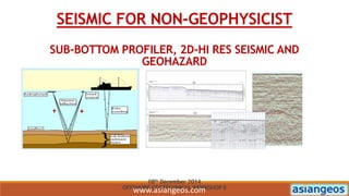
www.asiangeos.com
How They Work
 The sub bottom profiler data recorded in millisecond (ms) two
way time (TWT)
 Two way time = time travel to seafloor/layer + time travel to
receiver
 Velocity assume value of 1600m/s-consider of solid velocity is
higher than water velocity. The water velocity range in Malaysia
is around 1540m/s
www.asiangeos.com
FREQUENCY AND RESOLUTION
HIGER
FREQUENCY
SYSTEM
HIGER FREQUENCY
SIGNALS HAVE
SHORTER WAVE
LENGTHS AND ARE
ABLE TO
DISCRIMINATE
BETWEEN LAYERS
THAT ARE CLOSE
TOGETHER
PINGER
AND CHIRP
LOW
PENETRATION
HIGH
RESOLUTION
LOWER
FREQUENCY
SYSTEMS
LONGER SOUND
PULSE LENGTHS
TRANSMIT MORE
ENERGY AND
YIELDS DEEPER
PENETRATION
BOOMER,
SPARKER
AND MINI
AIR GUN
HIGH
PENETRATION
LOW
RESOLUTION
www.asiangeos.com
SUB BOTTOM PROFILER
SYSTEM CHARACTERISTICS VARIOUS CLASSES OF SUB BOTTOM PROFILER
www.asiangeos.com
PINGER AQUISITION
Side Mounted Pole
Hull Mounted Pole
Transducer
www.asiangeos.com
BOOMER AQUISITION
Mini Streamer Frame Deployment
Mini Streamer-Hydrophone
Boomer Plate with Catamaran
www.asiangeos.com
PINGER
www.asiangeos.com
CHIRP
www.asiangeos.com
BOOMER
www.asiangeos.com
SPARKER
www.asiangeos.com
MINI AIR GUN
www.asiangeos.com
CODA GEO SURVEY SOFTWARE
www.asiangeos.com
USE FOR INTERPERTATION
 PROFILES
 ISOPACH MAP
 CHANNEL MAP
 SHALLOW ANOMALY
 SHALLOW FAULT
www.asiangeos.com
GEOLOGICAL PROFILE
www.asiangeos.com
ISOPACH MAP
www.asiangeos.com
SHALLOW CHANNEL MAP
www.asiangeos.com
SHALLOW ANOMALIES AND FAULT MAP
www.asiangeos.com
CORRELATION BETWEEN SBP AND
GEOTECHNICAL SOIL DATA
www.asiangeos.com
2D HI-RES SEISMIC DATA
www.asiangeos.com
2D HI-RES SEISMIC DATA ACQUITION SYSTEM
EQUIPMENT
• FUGRO STARFIX POSITIONING SYSTEM
• 96-CHANNEL SEAMUX 3 SOLID
• HYDOSCIENCE NTRS 2
• 150 CU.IN GI GUN
AQUISTION PARAMETERS
• SHOT INTERVAL:12.5 M
• GOUP INTERVAL: 12.5 M
• SAMPLING RATES: 1MS
• RECORDING LENGTH: 2S
www.asiangeos.com
EQUIPMENT LAYOUT
www.asiangeos.com
EQUIPMENT DEPLOYMENT
Streamer Winch and Birds
Streamer
GI Gun
Tail BuoyStreamer and birds deployment In Operation
www.asiangeos.com
2DHR SEISMIC DATA INTERPRETATION
0.000
0.100
0.200
0.300
0.400
0.500
0.600
0.700
0.800
0.900
1.000
1.100
1.200
1.300
1.400
1.500
1.600
1.700
1.800
1.900
2.000
0.100
0.200
0.300
0.400
0.500
0.600
0.700
0.800
0.900
1.000
1.100
1.200
1.300
1.400
1.500
1.600
1.700
1.800
1.900
2.000
120.0150.0180.0210.0
- D28-AD-20 -
240.0270.0300.0SP:
0.000
0.100
0.200
0.300
0.400
0.500
0.600
0.700
0.800
0.900
1.000
1.100
1.200
1.300
1.400
1.500
1.600
1.700
1.800
1.900
2.000
D28-AD-36, 129.66D28-AD-34, 130.00D28-AD-33, 130.24D28-AD-32, 130.09D28-AD-31, 129.99D28-AD-30, 130.15D28-AD-29, 243.96D28-AD-28, 243.97D28-AD-27, 244.36D28-AD-26, 243.90D28-AD-25A, 1244.12D28-AD-24, 244.28
Seismic Section Equalized Data-EQL Seismic Section Real amplitude pulse-RAP
www.asiangeos.com
2DHR SEISMIC DATA INTERPRETATION
Seismic Section Equalized Data-EQL Seismic Section Real amplitude pulse-RAP
www.asiangeos.com
2DHR SEISMIC DATA INTERPRETATION
Seismic Section Equalized Data-EQL Seismic Section Real amplitude pulse-RAP Anomalies and Faults Chart
www.asiangeos.com
GEOHAZARD
Definition:
a geological state that may lead to widespread damage or risk.
These can be long term or short term geological and/or
environmental conditions that are associated with normal
geological processes. Geohazard investigation involve using
specialized equipment to determine the severity of this state/risk.
www.asiangeos.com
GEOHAZARD
Blow Out Punch Through
Oil Spill PollutedBlow Out
www.asiangeos.com
GEOPHYSICAL SITE SURVEY
Geophysical site survey:
Survey to support dredging and reclamation projects; determine
filling/dredging quantities; outline seabed train & sub seabed
profile.
Survey to locate underwater objects, ensure under-keel clearance
of fairways
Survey for shallow and deeper geologic study and hazard
definition.
www.asiangeos.com
GEOPHYSICAL EQUIPMENT
Geophysical equipment for geohazard study:
• Echo Sounders- single beam and multibeam
• Side Scan Sonars
• Magnetometer
• Sub Bottom Profilers
• 2D Hi Res Seismic
• Autonomous Underwater Vehicle (AUV).
www.asiangeos.com
GEOPHYSICAL EQUIPMENT
Single beam/multibeam echo sounder
MBES System
MBES 3D Image
Transducers
SBES System Transducer
www.asiangeos.com
GEOPHYSICAL EQUIPMENT
Side Scan Sonar
SSS System SSS-Tow-fish SSS Tow-fish
SSS Data
www.asiangeos.com
GEOPHYSICAL EQUIPMENT
Magnetometer
Magnetometer System
Magnetometer Data Analysis
Magnetometer Fish
www.asiangeos.com
GEOPHYSICAL EQUIPMENT
Sub Bottom Profiler
Mini Streamer-Hydrophone
Transducer-Pinger
Sparker and Catamaran
SBP Data
www.asiangeos.com
GEOPHYSICAL EQUIPMENT
2D Hi- Res Seismic
Streamer with winch
Seismic Source – GI Gun
Seismic data - Raw
Seismic data - Migration
www.asiangeos.com
GEOPHYSICAL EQUIPMENT
Autonomous Underwater Vehicle (AUV).
AUV-In Operating
High Resolution AUV data
AUV-Recovery
www.asiangeos.com
TYPES OF GEOPHYSICAL SURVEYS FOR
GEOHAZARD STUDY
• Analogue Debris Survey
• Pipeline Route Survey
a) Proposed pipeline route survey
b) Pre-lay pipeline route survey
c) Post-lay pipeline route survey
d) Pipeline surveillance survey
• Analogue and Digital Site Survey
www.asiangeos.com
THE IMPORTANCE OF SITE SURVEY FOR
GEOHAZARD STUDY
It provide high definition data and images of the specific areas for
development and set down of subsea facilities
It provides detailed seabed and sub seabed image and profiles
within the first 50 metres below seabed for seabed and shallow
foundation & design.
It provides (2DHR) high resolution and detailed sub seabed images
and profiles within the first 1 seconds TWT in the attempt to map
delineate shallow gas hazards that may pose a constraint to
drilling- improving/enhancing 3D data interpretation.
www.asiangeos.com
EXAMPLE OF GEOHAZARD
CORAL- Impact for anchoring and rig emplacement activity.
Multibeam Data Side Scan Sonar Mosaic
Seabed Features with Anchor Pattern
www.asiangeos.com
EXAMPLE OF GEOHAZARD
SHALLOW PALEO CHANNEL-Potential to jack-up rig punch through
Seismic Section Equalized Data-EQL
Sub Bottom Profile- Sparker Data
Channel Pattern in Drawing Chart
www.asiangeos.com
EXAMPLE OF GEOHAZARD
SHALLOW PALEO CHANNEL-Potential to jack-up rig punch through
Seismic Section Equalized Data-EQL
Sub Botom Profile- Sparker Data
Channel Pattern in Drawing Chart
www.asiangeos.com
EXAMPLE OF GEOHAZARD
SEISMIC ANOMALIES- Potential Gas seepage/Shallow Gas
Seismic Section Real Amplitude Pulse Anomalies Pattern in Drawing Chart
www.asiangeos.com
EXAMPLE OF GEOHAZARD
SEISMIC ANOMALIES- Potential Gas seepage/Shallow Gas
Sub Bottom Profile Sparker Data
Anomaly Pattern in Drawing Chart
www.asiangeos.com
THANK YOU

More Related Content

What's hot

Large Dia Well Tests
Large Dia Well TestsLarge Dia Well Tests
Large Dia Well TestsAnand A.V.S.S
 
Sequence stratigraphy and its applications
Sequence stratigraphy and its applicationsSequence stratigraphy and its applications
Sequence stratigraphy and its applicationsPramoda Raj
 
formation evaluation chapter 1
formation evaluation chapter 1formation evaluation chapter 1
formation evaluation chapter 1mohamadfadhli
 
Bond log theory and interpretation
Bond log theory and interpretationBond log theory and interpretation
Bond log theory and interpretationBRIKAT Abdelghani
 
Borehole and Drilling problems
Borehole and Drilling problems  Borehole and Drilling problems
Borehole and Drilling problems Vívêk Årýàñ
 
Underbalance drilling equipment
Underbalance  drilling equipmentUnderbalance  drilling equipment
Underbalance drilling equipmentshivan abdalrahman
 
New burn cut blast design in drives enhances drilling blasting efficiency wit...
New burn cut blast design in drives enhances drilling blasting efficiency wit...New burn cut blast design in drives enhances drilling blasting efficiency wit...
New burn cut blast design in drives enhances drilling blasting efficiency wit...partha sharma
 
Basic geology for Oil Exploration
Basic geology for Oil ExplorationBasic geology for Oil Exploration
Basic geology for Oil ExplorationDavid Simatupang
 
Presentation1 practical purposes of mud logging
Presentation1 practical purposes of mud loggingPresentation1 practical purposes of mud logging
Presentation1 practical purposes of mud loggingelharith mohamed
 
Routine core analysis and special core analysis
Routine core analysis and special core analysisRoutine core analysis and special core analysis
Routine core analysis and special core analysisShujaSamejo
 
Volcanogenic Massive Sulfide Occurrence Model
Volcanogenic Massive Sulfide Occurrence ModelVolcanogenic Massive Sulfide Occurrence Model
Volcanogenic Massive Sulfide Occurrence ModelRemote Sensing GEOIMAGE
 
Presentation 4 mudlogging
Presentation 4 mudloggingPresentation 4 mudlogging
Presentation 4 mudloggingAli Trichelli
 

What's hot (20)

Large Dia Well Tests
Large Dia Well TestsLarge Dia Well Tests
Large Dia Well Tests
 
Coring
CoringCoring
Coring
 
Sequence stratigraphy and its applications
Sequence stratigraphy and its applicationsSequence stratigraphy and its applications
Sequence stratigraphy and its applications
 
formation evaluation chapter 1
formation evaluation chapter 1formation evaluation chapter 1
formation evaluation chapter 1
 
Bond log theory and interpretation
Bond log theory and interpretationBond log theory and interpretation
Bond log theory and interpretation
 
Group 04
Group 04Group 04
Group 04
 
Borehole and Drilling problems
Borehole and Drilling problems  Borehole and Drilling problems
Borehole and Drilling problems
 
Tailings
TailingsTailings
Tailings
 
Underbalance drilling equipment
Underbalance  drilling equipmentUnderbalance  drilling equipment
Underbalance drilling equipment
 
Cutting analysis (part 1)
Cutting analysis (part 1)Cutting analysis (part 1)
Cutting analysis (part 1)
 
slope stability and computers
 slope stability and computers slope stability and computers
slope stability and computers
 
New burn cut blast design in drives enhances drilling blasting efficiency wit...
New burn cut blast design in drives enhances drilling blasting efficiency wit...New burn cut blast design in drives enhances drilling blasting efficiency wit...
New burn cut blast design in drives enhances drilling blasting efficiency wit...
 
Caving Underground Mining Methods (longwall, Sublevel caving, & Block caving)
Caving Underground Mining Methods (longwall, Sublevel caving, &  Block caving)Caving Underground Mining Methods (longwall, Sublevel caving, &  Block caving)
Caving Underground Mining Methods (longwall, Sublevel caving, & Block caving)
 
Types of Drilling
Types of Drilling Types of Drilling
Types of Drilling
 
Basic geology for Oil Exploration
Basic geology for Oil ExplorationBasic geology for Oil Exploration
Basic geology for Oil Exploration
 
Presentation1 practical purposes of mud logging
Presentation1 practical purposes of mud loggingPresentation1 practical purposes of mud logging
Presentation1 practical purposes of mud logging
 
Routine core analysis and special core analysis
Routine core analysis and special core analysisRoutine core analysis and special core analysis
Routine core analysis and special core analysis
 
Volcanogenic Massive Sulfide Occurrence Model
Volcanogenic Massive Sulfide Occurrence ModelVolcanogenic Massive Sulfide Occurrence Model
Volcanogenic Massive Sulfide Occurrence Model
 
Density log and its uses
Density log and its usesDensity log and its uses
Density log and its uses
 
Presentation 4 mudlogging
Presentation 4 mudloggingPresentation 4 mudlogging
Presentation 4 mudlogging
 

Similar to SEISMIC FOR NON-GEOPHYSICIST: SUB-BOTTOM PROFILER, 2D-HI RES SEISMIC AND GEOHAZARD

Pipeline Depth Of Cover Surveys
Pipeline Depth Of Cover SurveysPipeline Depth Of Cover Surveys
Pipeline Depth Of Cover SurveysSidescan
 
Site Surveys_Rig Safety-Link
Site Surveys_Rig Safety-LinkSite Surveys_Rig Safety-Link
Site Surveys_Rig Safety-LinkAbdul Rahim
 
Edgetech Marine technologies presentation at Codevintec's Workshop (by Nick L...
Edgetech Marine technologies presentation at Codevintec's Workshop (by Nick L...Edgetech Marine technologies presentation at Codevintec's Workshop (by Nick L...
Edgetech Marine technologies presentation at Codevintec's Workshop (by Nick L...Codevintec Italiana srl
 
VIV monitoring enhancing the safety of drilling operations in high current en...
VIV monitoring enhancing the safety of drilling operations in high current en...VIV monitoring enhancing the safety of drilling operations in high current en...
VIV monitoring enhancing the safety of drilling operations in high current en...Pulse Structural Monitoring
 
The Value Proposition of 3D and 4D Marine Seismic Data
The Value Proposition of 3D and 4D Marine Seismic DataThe Value Proposition of 3D and 4D Marine Seismic Data
The Value Proposition of 3D and 4D Marine Seismic DataTaylor Goss
 
Petroleum lunch seminar 30.10.2014
Petroleum lunch seminar 30.10.2014Petroleum lunch seminar 30.10.2014
Petroleum lunch seminar 30.10.2014Geodata AS
 
Ocean Optics: Fundamentals & Naval Applications Technical Training Short Cour...
Ocean Optics: Fundamentals & Naval Applications Technical Training Short Cour...Ocean Optics: Fundamentals & Naval Applications Technical Training Short Cour...
Ocean Optics: Fundamentals & Naval Applications Technical Training Short Cour...Jim Jenkins
 
Demzy's Presentation on HDD
Demzy's Presentation on HDDDemzy's Presentation on HDD
Demzy's Presentation on HDDDemzy George
 
Overview To Linked In
Overview To Linked InOverview To Linked In
Overview To Linked Inkaadera
 
Vs30 measurements for Seismic Site Classification
Vs30 measurements for Seismic Site ClassificationVs30 measurements for Seismic Site Classification
Vs30 measurements for Seismic Site ClassificationAli Osman Öncel
 
SSS, SBP e altri Sonar marini - CodevintecDays mag-23.pdf
SSS, SBP e altri Sonar marini - CodevintecDays mag-23.pdfSSS, SBP e altri Sonar marini - CodevintecDays mag-23.pdf
SSS, SBP e altri Sonar marini - CodevintecDays mag-23.pdfCodevintec Italiana srl
 
Hfem dighem general presentation
Hfem dighem general presentationHfem dighem general presentation
Hfem dighem general presentationBrett Johnson
 
Introduction to Navigation Systems
Introduction to Navigation SystemsIntroduction to Navigation Systems
Introduction to Navigation SystemsJoseph Hennawy
 
Advantages of a combined sonar data acquisition system for AUVs and ASVs
Advantages of a combined sonar data acquisition system for AUVs and ASVsAdvantages of a combined sonar data acquisition system for AUVs and ASVs
Advantages of a combined sonar data acquisition system for AUVs and ASVsHydrographic Society Benelux
 
High pressure full-bore flow meter
High pressure full-bore flow meterHigh pressure full-bore flow meter
High pressure full-bore flow meterFrank-Michael Jäger
 
Fisheries Acoustics 102 - Applications
Fisheries Acoustics 102 - ApplicationsFisheries Acoustics 102 - Applications
Fisheries Acoustics 102 - ApplicationsBob McClure
 
Renewable Ocean Energy & the Marine Environment - New Environmental Technologies
Renewable Ocean Energy & the Marine Environment - New Environmental TechnologiesRenewable Ocean Energy & the Marine Environment - New Environmental Technologies
Renewable Ocean Energy & the Marine Environment - New Environmental TechnologiesBob McClure
 

Similar to SEISMIC FOR NON-GEOPHYSICIST: SUB-BOTTOM PROFILER, 2D-HI RES SEISMIC AND GEOHAZARD (20)

Pipeline Depth Of Cover Surveys
Pipeline Depth Of Cover SurveysPipeline Depth Of Cover Surveys
Pipeline Depth Of Cover Surveys
 
Site Surveys_Rig Safety-Link
Site Surveys_Rig Safety-LinkSite Surveys_Rig Safety-Link
Site Surveys_Rig Safety-Link
 
Edgetech Marine technologies presentation at Codevintec's Workshop (by Nick L...
Edgetech Marine technologies presentation at Codevintec's Workshop (by Nick L...Edgetech Marine technologies presentation at Codevintec's Workshop (by Nick L...
Edgetech Marine technologies presentation at Codevintec's Workshop (by Nick L...
 
VIV monitoring enhancing the safety of drilling operations in high current en...
VIV monitoring enhancing the safety of drilling operations in high current en...VIV monitoring enhancing the safety of drilling operations in high current en...
VIV monitoring enhancing the safety of drilling operations in high current en...
 
Sub Bottom Profiler QGI.pdf
Sub Bottom Profiler QGI.pdfSub Bottom Profiler QGI.pdf
Sub Bottom Profiler QGI.pdf
 
The Value Proposition of 3D and 4D Marine Seismic Data
The Value Proposition of 3D and 4D Marine Seismic DataThe Value Proposition of 3D and 4D Marine Seismic Data
The Value Proposition of 3D and 4D Marine Seismic Data
 
Petroleum lunch seminar 30.10.2014
Petroleum lunch seminar 30.10.2014Petroleum lunch seminar 30.10.2014
Petroleum lunch seminar 30.10.2014
 
Ocean Optics: Fundamentals & Naval Applications Technical Training Short Cour...
Ocean Optics: Fundamentals & Naval Applications Technical Training Short Cour...Ocean Optics: Fundamentals & Naval Applications Technical Training Short Cour...
Ocean Optics: Fundamentals & Naval Applications Technical Training Short Cour...
 
Demzy's Presentation on HDD
Demzy's Presentation on HDDDemzy's Presentation on HDD
Demzy's Presentation on HDD
 
Overview To Linked In
Overview To Linked InOverview To Linked In
Overview To Linked In
 
Vs30 measurements for Seismic Site Classification
Vs30 measurements for Seismic Site ClassificationVs30 measurements for Seismic Site Classification
Vs30 measurements for Seismic Site Classification
 
SSS, SBP e altri Sonar marini - CodevintecDays mag-23.pdf
SSS, SBP e altri Sonar marini - CodevintecDays mag-23.pdfSSS, SBP e altri Sonar marini - CodevintecDays mag-23.pdf
SSS, SBP e altri Sonar marini - CodevintecDays mag-23.pdf
 
Hfem dighem general presentation
Hfem dighem general presentationHfem dighem general presentation
Hfem dighem general presentation
 
Introduction to Navigation Systems
Introduction to Navigation SystemsIntroduction to Navigation Systems
Introduction to Navigation Systems
 
multibeam
multibeammultibeam
multibeam
 
Brown_ESTF2011
Brown_ESTF2011Brown_ESTF2011
Brown_ESTF2011
 
Advantages of a combined sonar data acquisition system for AUVs and ASVs
Advantages of a combined sonar data acquisition system for AUVs and ASVsAdvantages of a combined sonar data acquisition system for AUVs and ASVs
Advantages of a combined sonar data acquisition system for AUVs and ASVs
 
High pressure full-bore flow meter
High pressure full-bore flow meterHigh pressure full-bore flow meter
High pressure full-bore flow meter
 
Fisheries Acoustics 102 - Applications
Fisheries Acoustics 102 - ApplicationsFisheries Acoustics 102 - Applications
Fisheries Acoustics 102 - Applications
 
Renewable Ocean Energy & the Marine Environment - New Environmental Technologies
Renewable Ocean Energy & the Marine Environment - New Environmental TechnologiesRenewable Ocean Energy & the Marine Environment - New Environmental Technologies
Renewable Ocean Energy & the Marine Environment - New Environmental Technologies
 

SEISMIC FOR NON-GEOPHYSICIST: SUB-BOTTOM PROFILER, 2D-HI RES SEISMIC AND GEOHAZARD