SlideShare una empresa de Scribd logo
1 de 45
B&V Information/Asset Management
Delivering Benefits to Water Utilities
Ian Bush
bushi@bv.com P: 01737 856283
Paul Hart
hartp@bv.com P: 01737 856568
Louise Irvine
irvinel@bv.com P: 01737 852707


                                         01/2013
B&V Information Management Offering
• 25 staff globally                              Automated property boundary definition


• GIS, IT consultancy, application
  development & system integration
  experience
• Experts in all aspects of data
  management
• Strong spatial analysis focus
• Asset information management
  expertise
• Primarily work with utilities, local
  and national governments
• Mandate to improve use of
  information management on
  B&V projects
• Enabling clients to make better
  decisions

                                         Determining building height


                                                                                          2
How does IM make a difference?


                                 3
Some of the Technical Services we provide
• GIS/IM strategic, technical consultancy and training (e.g. GIS
  strategy, Needs assessment, technical due diligence)
• Asset Management (e.g. Asset inventory, PAS 55 assessment,
  Asset investment planning, maintenance prioritisation, Asset data
  model design, Asset survey)
• Evaluation analysis and management of all forms of geospatial
  data
• Site and route planning
• Geo-spatial analysis to support geo-engineering (e.g. cut & fill
  analysis, volumes, subsurface modelling)
• Generation, analysis and visualisation of 3D models (e.g. surface
  models, watershed delineation, viewsheds, 3D fly-throughs)
• Mobile mapping and capture systems (e.g electronic asset
  condition surveys)
• Environmental services (e.g. support for habitat creation, EIA/SEA
  assessments, surveys, stakeholder consultation, planning)
• Alternative energy assessments (e.g. site suitability for Biomass,
  Wave, Wind, Solar)
                                                                       4
More technical services...
• Economic impact analysis
• Flood risk management (e.g. Generation of ground models,
  interpretation of modelling results, economic appraisals, etc)
• Coastal Management (e.g. Coastal zone surveys, Historic Trend
  Analysis, Beach profile change)
• Geospatial statistics
• Hydrodynamic and network modelling support (e.g subcatchment
  generator)
• Landscape assessment (e.g photo-realistic impressions and
  photomontages)
• Application development and system integration
• Relational database design, development and management
• Business process improvement
• Web site, portal & dashboard design and development including
  map authoring
• Geomatics services (e.g. Map making and reproduction, data
  capture, translation, metadata management, aerial map services)
                                                                    5
Benefits of our approach
 Standard, repeatable                                                 Where appropriate can
   rules agreed with                                                       include CCG
     client to meet                                                    representation in the
     specific needs              Frequently a common                  approach, development
                                   stage in a delivery                     and outputs
                                        process

               Fast, reliable,
                consistent,
                 accurate                              SWS have access to
                                                      leading skill sets and
                                                           experience
                                     High
        Able to support           value, low
         business plan               cost
                                                                                 Can interface
                                                                                  with client
                                 Frequently visible                            datasets e.g. unit
                                  outputs support                               cost database
  Outputs can be
                                   interpretation
strategic or tactical
  – solutions are                                             Uses a combination
     ‘drillable’                                               of public domain,
                                                              client and derived
                                                                      data


                                                                                                    6
Clients we have delivered benefits to...


                                           7
Some examples...


                   8
Customer Analysis & Rollout Database                      Automated SubCatchment Generator Tool
           A comprehensive metering strategy to assist in the        Division of network catchment area into smaller
           effective management of supply/demand balance             model-able subcatchments


1 1 /02 /2 01 1   11


          Pipeline Routing Optimisation Method                       Pollution Risk Assessment
          (PROM)
                                                                     Consideration of catchment risks and source
          Cost effectively and comprehensively consider the
                                                                     protection as an alternative to end of pipe
          supply options for a water resource strategy
                                                                     treatment


                                                                     Bathing Waters Investigations – South Coast
        Trunk Mains Risk Model
       Develop a risk model for Trunk Mains to identify and          Storm water sewer systems identified as a major
       mitigate potential risk and drive the capital                 source of microbial contamination of bathing waters
       investment programme


         Serviceability Dashboard                                    PAS 55 – Asset Management Benchmarking
           Providing access to ‘drillable’ serviceability business   Assisting SEW to attain PAS 55 accreditation with the
           intelligence at all levels within the organisation        Asset Management Insight System (AMIS)


         Project Risk Optimisation and                               Private Pump Station Strategic Planning
         Visualisation Engine (PROVE)                                Identification and survey strategy supported by innovative
           Visualise the risk and consequence for any time           system
           period in programme horizon


           Flood Damage Economics Model (FDEM)                       Proactive Comm Pipe Replacement
          A GIS based approach to the flood risk economic            A risk based approach to proactive maintenance
          assessment process


                                                                                                                              9
Sewerage Infrastructure Service Outcome
      Schemes
   (from capital works
    programme, new
      developments)
                             Strategic
                             Studies
                                                       Jobs
                                                  (from work orders)
                                                                            Ad-hoc
                                                                            (redlining)

                                                                                                                                                   APA Canal Asset Information Strategy                    Measures Analysis
                                                                                           New Property
                                                                                             Data File


                                                                                                                                                  Strategic consultancy to improve the asset information
                               Data Maintenance Procedures


                                                                                                            Other ACS Systems
                                                                                                     (Customer Billing ‘SAP’, Customer Enquiry,
                                                                                                                                                                                                           Identify the root causes behind an increase in
                                                                                                                                                  management of a Romanian waters utility networks
                              Unique Reference Management                                                Work Order Management, Capital
                                                                                                         Maintenance/investment Planning,
                                                                                                                  Monitoring, etc)


                                                                                                                                                                                                           pollution incidents
 Below Ground Data                                Area/Zones           Customer/Property
                         Above Ground Data
(GIS Asset Database)                         (GIS Asset Database)            Data


                                                                                                                                                   Anaerobic Digestion (AD) Supply Chain                   2012 Olympic Games
                                                                                                                                                   Assessment                                              Reducing the risk of asset failures during the
                                                                                                                                                   Complex interaction between contributing factors and    Olympics
                                                                                                                                                   constraints


                                                                                                                                                                                                           Pressure Profiling
                                                                                                                                                   Key Asset Security and Condition Surveys
                                                                                                                                                                                                           Identify key areas where pressure management
                                                                                                                                                   Gap analysis of security and emergency
                                                                                                                                                                                                           studies should be performed for potential network
                                                                                                                                                   measures at ‘at risk’ sites
                                                                                                                                                                                                           optimisation


                                                                                                                                                   Mogden WwTW Upgrade – New Process                       Trunk Mains Database
                                                                                                                                                   Stream,                                                 A central repository for asset, asset condition and
                                                                                                                                                   Sludge Plant and Other Works
                                                                                                                                                                                                           capital works data for Trunk Mains
                                                                                                                                                   Earthworks associated with the
                                                                                                                                                   upgrade of the works


                                                                                                                                                  Countryside Agency ‘Right to Roam’                       Consistent Flood Warning Thresholds
                                                                                                                                                  National mapping and consultation exercise to map        To define the new flood warning thresholds for 3
                                                                                                                                                  open country and Registered Common Land in               levels of flood impact for 180 Community Flood
                                                                                                                                                  England                                                  Warning Areas (CFWAs)


                                                                                                                                                  National Bio-fuel Supply Database                         Pipeline Studies in Chile
                                                                                                                                                                                                            Feasibility study for the transfer of water
                                                                                                                                                  development a centralised online database of              from the Pacific Ocean to a mining complex
                                                                                                                                                  bio-fuel suppliers detailing the services they            200km inland and 3,500m above sea level
                                                                                                                                                  provide


                                                                                                                                                                                                                                                                 10
Severn Estuary Tidal Power SEA
Mapping Access Database v3 (MAD3)                   Strategic Environmental Assessment of tidal power
Development of an Oracle Spatial 10g                generation in the Severn Estuary, plus stakeholder
Enterprise data repository, migrating all project   engagement, energy yield modelling and engineering
related and a number of corporate datasets          design work.


River Wandle Asset Inspection Survey                Asset Intervention Database
                                                    Manage huge volumes of capital investment
Condition survey of the River Wandle and
                                                    planning data to support the development of the
produce a report providing detailed
                                                    investment programme during the business plan
information on every fluvial defence and
                                                    review
structure

                                                    Cherry Cobb Sands Flood Compensation
Deben Flood Risk Management Strategy
                                                    Identify a suitable site for flood compensation
The development of a long-term strategy to          and undertake detailed design
manage the flood defences for three of the
Suffolk Estuaries


 Bedfont Court Flood Alleviation                    Offshore Tidal Power
 Detailed Design                                    Model the tidal flows around the whole of the
 Flood compensation and earthworks                  UK covering the extent of the UK Continental
 volumetric calculations related to flood bund      Shelf
 design near Heathrow Airport


                                                                                                         11
CONTACT DETAILS

                           Ian Bush
                           bushi@bv.com
                           P: 01737 856283

                           Paul Hart
                           hartp@bv.com
                           P: 01737 856568
Information Management


                           Louise Irvine
                           irvinel@bv.com
                           P: 01737 852707


                                             12
Customer analysis & rollout database (CustARD)
                         • Need: Develop a comprehensive metering strategy to assist in the effective
                           management of supply/demand balance
                         • Challenge: Minimising impact on customers (e.g.
                           Affordability) and cost of delivery, protecting
                           company revenue, maximising engagement with
                           stakeholders, upholding fairness and equity
                         • Solution: A geo-database decision support tool which
                           assists in managing the customer relationship
                         • Estimates post metering consumption
                         • Allocates attributes e.g. income, property type to
                           individual households
                         • Accurate and fully auditable
                                                                                                        Customer impact covering company area
                                                                             • Enables customer segmentation and profiling,
Information Management


                                                                               and a focussed service offerings
                                                                             • Benefits: Has meet challenges and produced
                                                                               a optimised metering programme
                                                                             • An 6 figure CAPEX saving and 10% uplift in
                                                                               optants (customers opting to install a meter)
                                                                             • Improved relationship with regulator
                                                                             • Peer reviewed and considered most advanced
                                                                               and comprehensive customer analysis tool in
                                                                               the UK water business
                                                                             • Other challenges can benefit
                                                                               from CustARD                               13
                             Customer impact Dashboard
Automated SubCatchment Generator Tool
                                                                • Need: Most time consuming and difficult task is defining
                                                                  the catchment areas and the percentage of impermeable
                                                                  surfaces when building a sewer system network model
                                                                  (e.g. For Drainage Area Plans)
                                                                • Challenges: Division of complex network catchment into
                                                                  smaller manhole based subcatchments
                                                                • Traditionally a time consuming manual task
                                                                • Complex set of rules to define divisions and determine
                                                                  impermeable areas
                                                                • Solution: Tool created to use set inputs and apply
                                                                  hierarchical set of business rules to generate model
                                  Intuitive tool input screen
                                                                  ready subcatchments
                                                                • Analysis is undertaken to determine all roofs, roads,
                                                                  paths, property boundaries and any other semi/
Information Management


                                                                  impermeable areas
                                                                • Attribution – areas are automatically measured, and
                                                                  codes assigned creating a ‘network model ready’ file
                                                                • Benefits: Time savings of >80% - the model rather than
                                                                  the modeller generates subcatchments
                                                                • Improved modelling –more detailed catchments
                                                                  providing a better representation of run-off
                                                                • Consistency – Judgement is removed so all catchments
                                                                  based on the same rules

                                                                                                                       14
                                         Subcatchments
Pipeline Routing Optimisation Method
                          (PROM)                                             Automated Reporting


                         • Need: How to cost effectively and
                           comprehensively consider the supply options
                           for a water resource strategy
                         • Challenge: Complex landscape, many
                           constraints, limited budget, lots of alternatives,
                           equal consideration
                         • Solution: GIS tool determines best route
                         • Considers all geotechnical, human and
                           environmental constraints at the same time
                         • Weighting and combining 50-70+ decisional
                           datasets
                         • Any number of start locations/options
                                                                              • Benefits: Significant time and cost saving for
                         • Automatic reporting: profiles, schedules, maps
Information Management


                                                                                route planning – typically £25 to£40k
                                                                              • Minimizes capex and opex (e.g. £250K)
                                                                              • Provides quantitative information to support
                                                                                due diligence
                                                                              • Quickly compare the merits of one route with
                                                                                another
                                                                              • Use of expert resources as verification and not
                                                                                for whole assessment process
                                                                              • Now used in other areas of the business
                                                                                (infra. Planning, price review)
                                                                              • Reusable on whole utility area                 15
                            PROM Least Cost Database
Pollution Risk Assessment
                                                                                 • Need: To comply with it regulatory obligations
                                                                                   (WSR and WFD) Thames Water need to understand
                                                                                   the risks of pollutants entering the water supply
                                                                                   chain.
                                                                                 • Need to devise a catchment based risk assessment
                                                                                   methodology for both its surface water intakes and
                                                                                   its groundwater abstraction points.
                                                                                 • Challenges: Large amounts of disparate data
                                                                                   across a large geographic area, poor data accuracy,
                                                                                   complex interaction between natural surfaces and
                                                                                   sewer/stormwater networks

                          Catchment Risk Map                                                     • Solution: GIS-based quantitative
                         • Benefits: Provided TW with a Intakes Watercourses                       assessment of catchment risks and
                                                                                                   source protection
Information Management


                           simple risk classification to
                           identify high priority water                                          • Hazard  Pathway  Receptor
                           sources                                                                 approach
                         • Improved data and                                                     • Risk-based approach included
                           catchment understanding                                                 severity, impact and likelihood
                         • Provided tools to undertake a                                           factors
                           proactive and collaborative                                           • Quantifiable, repeatable and
                           approach to understanding                                               auditable method for catchment
                           and mitigating against                                                  risk assessment
                           catchment risks                                                         Catchments
                         • Immediate and effective due
                           diligence support                 Simple Surface Water Pathway
                                                                                                                                  16
Trunk Mains Risk Modelling
                         • Need: Develop a risk model for Trunk Mains to identify and mitigate potential risk and
                           drive the capital investment programme
                         • Challenge: Modelling probability and consequence of
                           failure individually for a large number of assets
                           (100,000+)
                         • Calculating risk using a common framework approach
                           allowing different types of consequence to be
                           compared with each other
                         • Incorporate potential solutions, including costs and
                           benefits of implementing the solutions to allow
                           investment planning                                                                    Risk displayed spatially
                         • Solution: A database decision support tool which • GIS analysis to model flood risk from
                           calculates risk and cost-benefit producing a list of   simulated bursts across the network
                           prioritised assets                                   • Network analysis to determine supply
Information Management


                                                                                  impacts from simulated bursts
                                                                                • Benefits: Has met challenges and produced a
                                                                                  commended Trunk Mains Risk Model
                                                                                • £100m+ investment case supported and
                                                                                  justified using the risk model
                                                                                • Investment case would not have been
                                                                                  approved by the regulator without the model
                                                                                • Considered the most advanced risk model for
                                                                                  Trunk Mains in the UK
                                                                                • Forerunner for other risk
                                                                                  models                                            17
                         Risk Model Dashboard and Risk Profile
Bathing Waters Investigations – South Coast
                         • Need: Stormwater sewer systems identified as a major source
                           of microbial contamination of bathing waters in Bognor Regis,
                           Worthing, Hastings and Broadstairs
                         • Challenges: Identify the assets that discharge through outfalls
                           close to the bathing waters
                         • The management, analysis and distribution of:
                          • large asset datasets (of variable quality)
                          • Significant amounts of monitoring data (e.g. 1,968
                            samples in a 6 hour period)
                                                                            Sample IAS Survey Plan               Stormwater Outfall at Hastings
                          • Manhole, CSO, pumping station, short                                        • Benefits: Has an
                            term flow and impermeable area surveys                                         understanding of the
                         • Solution: Assess bacteria loads; propose                                        contamination levels
                           remediation measures for surface water                                          within each sub-
Information Management


                           sewerage systems                                                                catchment/outfall
                         • Geodatabase to provide a centralised data                                    • Demonstrated to the
                           repository for analysis and distribution                                        Regulator the removal
                         • Automated routines to format incoming                                           of all mis-connections
                           data                                                                            will improve the
                                                                                                           bathing water quality
                         • Automated routines to clean data for                                      • Centralised, collated
                           network                                                                     geodatabase for version
                           hydraulic modelling                                                         control and data issue
                         • Automated extrapolation of sample                                         • Automated bulk map
                           IAS surveys to whole catchment                                              production
                           coverage                                                                    routines                 18
                                               Sample Monitoring Location Plan
Serviceability Dashboard (SERVIZ)
                         •      Need: To clearly communicate serviceability outcome measures suitable for all
                                levels within the organisation
                         • Challenge: To provide clear visibility of business
                                intelligence at a various levels of detail (drillable
                                data)
                         • Large amounts of disparate data residing in
                                various systems, changing over time
                         • Avoiding complex system integration
                         • Spatial correlation of assets
                         • Solution: Esintial Business Intelligence Platform
                         • Supports a spatial view alongside business KPIs                                             Individual Burst Detail
                                and metrics
                                                                                      • Benefits: Uses SEW existing infrastructure –
                         • Supports massive volumes of data from
Information Management


                                                                                        minimal infrastructure costs
                                disparate sources
                                                                                      • Easy to maintain and grow. Maintenance/
                                                                                        reporting productivity efficiency
                          Serviceability Dashboard
                                                                                      • Continual/timely evidence of serviceability
                                                                                        performance in an enterprise wide, stable,
                                                                                        easy to use and non-proprietary
                                                                                        environment
                                                                                      • Easy view of “Strategic” (Analysis/Planning)
                                                                                        “Tactical” (Operations) level
                                                                                        data in a single application                           19
PAS 55 - Asset Management Benchmarking
                         • Need: Assist SEW in attaining PAS 55 accreditation
                         • To demonstrate good practice Asset Management
                         • Identify improvements in both efficiency and
                           regulatory performance
                         • Challenges: Existing tools for assessing PAS 55
                           capabilities were hard to navigate and complicated
                         • South East Water at the start of the PAS 55 journey
                         • Many elements were not in place
                         • The rigid structure of these tools made effective
                           recording difficult, and subsequent reworking and
                           collaboration between assessors was time-           • B&V created an assessment tool that
                           consuming.                                            enabled rapid navigation and easy data
                                                                                 capture of asset management capabilities
Information Management


                                                                                 and supporting evidence
                         • Solution: South East Water sought B&V’s             • Benefits: Successfully attained accreditation
                           experience in Asset Management benchmarking
                           as Institute-of Asset Management endorsed           • Enabled B&V to provide SEW with an
                           assessors against the PAS 55 standard                 immediate score for each PAS 55 element
                                                                                 to identify high priority improvement
                                                                                 requirements
                                                                               • Improved data and evidence capture
                                                                               • Immediate feedback to assessors and SEW
                                                                                 ensured clarifications and challenges were
                                                                                 tackled instantly
                                                                                                                          20
Project Risk Optimisation and Visualisation
                              Engine (PROVE)
                          •      Need: To minimise the risk of interruption to customer supply resulting from the
                                 cumulative project impacts of their capital works programme (new mains, rehab,
                                 swabbing , cleaning, site works)
                          •      Challenge: Easily understand overlapping temporal
                                 and geographic project risk (probability,
                                 consequence), limited budget, short timeframe,
                                 central programme management
                          •      Solution: Engine directly connects with
                                 programme software (e.g. MS Project)
                          •      Customised programme to support additional
                                 reporting (e.g. Impacted DMA’s)
                          •      Calculates consequence using sensitive customer                                         MS Project Input
Information Management


                                 data                                               • Represents risk temporally in 3 dimensions
                                                                                       in a geographical context (in Google Earth)
                                                                                    • Benefits: Can visualise the risk and
                                                                                       consequence for any time period in
                                                                                       programme horizon
                                                                                    • Quickly understand the complexity of the
                                                                                       all the influencing factors
                                                                                    • Provides an easy means to iteratively
                                                                                       evaluate and mitigate risk
                         Google Earth Output
                                                                                                                                      21
Private Pump Station Strategic Planning
                         • Need: Change in legislation forcing utilities to adopt PPS by
                           2016. Need to determine best adoption strategy
                         • Challenges: Identifying number and location of PPS, Establish
                           cost of upgrading PPS to serviceable condition, collection of
                           disparate intelligence
                         • Solution: Identification and survey strategy supported by an
                           innovative system
                         • Comprehensive information sourcing approach from all
                           stakeholders (362 contacts from 106 organisations)
                         • Survey a sample (100) unadopted PPS to assess condition and a
                           further 500 location surveys
                         • Centralised spatial database to hold all survey, contact and PPS
                           information
Information Management


                                                                                                                      Intelligent electronic forms

                                                                                                                   Ruggedised tablet PC

                                                                                          • Database accessed using GIS, InfoPath and
                                                                                            Access with automatic reporting
                                                                                          • Benefits: Investment requirement known to
                                                                                            bring up to SW serviceable standard
                                                                                          • Extensive audit trail and information source
                                                                                            developed useful for further work
                                                                                          • Robust repeatable process
                                                       Automated, map based progress reporting                                                  22
Flood Damage Economics Model (FDEM)
                         • Need: Flood Strategies key consideration is the                               Spatially representing damage costs
                           economical appraisal of a number of flooding
                           scenarios. 1:5 Cost/Benefit ratio requirement
                         • Challenges: Vital to consider the economics
                           (capital, opex, whole life cost, operational
                           /embedded carbon impact) of all options at the
                           best possible level of detail
                         • More detailed digital data is becoming available at
                           a national and global level
                         • Solution: We have developed the Flood Damage
                           Economics Model (FDEM), allows focus on key
                           areas quickly using spatial oriented queries,
                           reporting and visualisation
                         • Fully scalable and is capable of supporting
Information Management


                           appraisals of small towns or entire regions or even • Economics calculated, reported and stored
                           entire nations                                                      at the property level
                         • Entire decision process can be thematically                       • Tool based consistent repeatable method
                           mapped
                                                                                             • Benefits: Improved property inclusion and
                                                                                               classification resulting in more accurate
                                                                                               appraisal
                                                                                             • Estimated 25% efficiency saving over
                                                                                               previous method
                                                                                             • Quickly can identify and quantify problem
                                                                                               areas
                                                       Spatially represent % contribution to
                                                       overall total
                                                                                             • Robust audit process better                   23
                                                                                               supports due diligence
Proactive Communication Pipe Replacement
                         • Need: Funding to invest in the proactive
                           maintenance of communication pipes (service
                           connections) but no robust and auditable method
                           for determining where to invest
                         • Challenges: Large disparate collection of asset
                           performance data
                         • Balance of depth of analysis vs tight budget
                         • Significant data gaps
                         • Difficult to create work packages
                         • Solution: Modelling risk to better target comm
                           pipe replacement (probability & consequence of
                           failure)
                         • Using known failures (work orders), soil type,                                     Scheduled work
                           pressure, property data to create cohorts
Information Management


                                                                             • Hot spot analysis to identify clusters of poor
                                                                               performing assets
                                                                             • Benefit: Schedule of proactive
                                                                               communication pipe work now included in
                                                                               AMP 5 capital maintenance programme
                                                                             • Creation of sensible work packages (i.e. Cost
                                                                               effective) at street level
                                                                             • Improved performance based data (infilling)
                                                                             • creation a spatial dataset to represent the
                                                                               communication pipes for
                                                                               entire company area
                                                                                                                               24
                                                     Density Analysis
APA Canal Asset Information Strategy
                           • Need: Strategic consultancy to improve the                                                                                                    SimpleJunctionFeature

                             asset information management of ACS water
                             distribution and sewerage networks
                                                                                                                                                                               WaterFacility


                           • Challenges: No Asset Information                                                             Manhole                  NetworkStructure               Meter                   Hydrant     Pump                 Valve

                             Management Strategy in place
                           • Extensive data management issues                                                             SamplingStation             ConnectionPoint           Fitting            StorageReservoir          SystemValve              ControlValve


                           • Lack of awareness within executive                                                                                                                                                                                    A Data Model


                                                                                                                                                    • Solution: Development of Asset
                                                                                                                                                      Information Strategy:
                               Schemes
                                                                                                                                                         • Short, medium, long term roadmap
                            (from capital works       Strategic                 Jobs                 Ad-hoc
                             programme, new
                               developments)
                                                      Studies              (from work orders)        (redlining)
                                                                                                                                                         • Full data, organisational and
                                                                                                                                                           technology gap analysis
                                                                                                                    New Property
                                                                                                                                                         • Corporate data model
Information Management


                                                                                                                      Data File

                                                        Data Maintenance Procedures
                                                                                                                                                              • Data collection/maintenance
                                                                                                                                                                 strategy
                                                                                                                                     Other ACS Systems
                                                       Unique Reference Management                                                                            • Organisational change
                                                                                                                              (Customer Billing ‘SAP’, Customer Enquiry,
                                                                                                                                  Work Order Management, Capital
                                                                                                                                  Maintenance/investment Planning,
                                                                                                                                            Monitoring, etc)
                                                                                                                                                                 requirements
                                                                                                                                                              • technology review
                          Below Ground Data                                Area/Zones           Customer/Property
                                                                                                                                                                 /recommendations.
                                                  Above Ground Data
                         (GIS Asset Database)                         (GIS Asset Database)            Data

                                                                                                                    • Benefit: Executive support
                                                                                                                    • New Asset Management Group formed with roles and
                         Data collection process                                                                      responsibilities
                                                                                                                    • Understand what is needed
                                                                                                                                                                       25
                                                                                                                    • Data improvement programme underway
Sewerage Infrastructure Service
                         Outcome Measures Analysis
                         • Need: Serviceability measure outcomes of SWS Sewerage
                           Infrastructure (SI) was ‘marginal’. Pollutions incidents
                           increasing
                         • Challenges: To link pump station performance, blockage
                           movement and/or changing demographics as cause for
                           increasing pollution incidents
                         • Disparate, large amounts of, and poorly recorded source data
                         • Solution: Integrated service using network modelling, GIS
                           database analysis, mapping and asset management expertise
                         • Analysed a complex array of physical and performance based                       Sewerage Blockage
                           asset data
                         • Built a number of spatial models to analysis the strength of
                           the correlation between source data and pollution incidents
Information Management


                                                                   • Benefit: Identified a number of operational and
                                                                     strategic recommendations to improve SWS’s
                                                                     serviceability measures including:
                                                                   • a new indicator for assessing pumping station
                                                                     deterioration
                                                                   • an early warning tool to for poor pumping station
                                                                     performance.
                                                                   • Defined the parameters with which to describe a
                                                                     sewer blockage movement.
                                                                   • Cost effective automated blockage
                                                                                                                       26
                          Serviceability reporting
                                                                     movement tool now in place
Anaerobic Digestion (AD) Supply Chain
                          Assessment - National Non-Food Crop Centre
                          • Need: To meet the UK challenge to accelerate the uptake of AD, this report contributed to the
                            analysis of different options in terms of inputs, outputs and technology options in order to identify
                            the most effective delivery of AD from an environmental and economic point of view, and optimal
                            locations for AD plants.
                          • Challenges: Complex interaction between contributing factors, variable data quality for the
                            different constraints available at different scales, national scale analysis, limited budget

                                                              • Solution: GIS as a criteria based decision support tool to
                                                                determine site suitability across the UK
                                                              • Considers contributing factors simultaneously
                                                                   • Availability of fuel source i.e. manure and/or food waste
                                                                   • Proximity to land suitable for the digestate (fertiliser)
                                                                      e.g. agricultural land
Information Management


                                                                   • Proximity to the gas grid as a destination for the biogas
                                                                   • Proximity to the electricity grid as a destination for the
                                                                      processed biogas
                                                              • Benefits: Centralised geodatabase, a single source of all
                                                                information:
                                                                   • Source data, weightings and results
                                                              • Automated routines and models to perform site suitability
                                                                calculations
                                                              • Summarised complex information relating to
                         Example UK site suitability map        AD development
                           Site Suitability Map
                                                              • UK AD site suitability map                                     27
2012 Olympic Games
                         • Need: Prepare the UK’s largest clean water
                           supplier for the world’s biggest sporting event
                         • Challenges: Large disparate collection of asset
                           performance data with significant data gaps
                         • High profile project with a tight schedule
                         • Resistance of local authorities to additional
                           works
                         • Solution: Develop an algorithm to identify
                           burst/leakage risks to the Games based on
                           proven methods within the business.
                         • Manually validate results to provide defensible,
                           necessary projects for monitoring and
                           rehabilitation.
Information Management


                                                                     • Warehouse all data to provide a central source for
                                                                       other client business interests (waste, planning,
                                                                       modelling)
                                                                     • Benefit: Comprehensive project identification
                                                                       format recognisable and acceptable by local
                                                                       authorities which identifies and mitigates potential
                                                                       risks to Olympic sporting events and patrons
                                                                     • Brand resilience during a high profile event
                                                                     • Data availability and consistency across the business

                                                                                                                         28
Key Asset Security and Condition Surveys
                                                                               • Need: Gap analysis of security and emergency
                                                                                 measures at ‘at risk’ sites
                                                                               • Challenge: Undertook 136 security surveys of
                                                                                 Southern Water assets, and a further 200 condition
                                                                                 surveys
                                                                               • Solution: Site visits optimised to improve efficiency
                                                                               • Data integrity maintained using centralised spatial
                                                                                 database
                                                                               • Field data captured on GPS enabled PDA
                                                                               • Location based data capture e.g. fence lengths
                         Site photos linked to assets and recorded in database
                                                                               • Onboard camera provided GPS tagged photos
                                                                                 automatically referenced to survey record
                         • Benefits: Use of PDA and forms improved
Information Management


                             data capture methodology
                         • Desk based post survey validation and
                             reporting using easy to use intelligent
                             electronic forms
                         • Viewed and edited by the multiple team
                             members
                         • Edits made in one application are
                             immediately visible in another
                         • Digital capture eliminated the requirement for                              Integrated field and desk based approach
                             post data entry and the associated potential for
                             errors.
                                                                                                                                                29
                         • Automated map and report generation
Pressure Profiling
                         • Need: Identify key areas where pressure
                           management studies should be performed for
                           potential network optimisation
                         • Challenges: Massive analysis area, 7,600 km2
                         • Client required a visual, non-numeric result
                         • Complex data sets with tens of millions of records
                         • Solution: Simplify data into manageable pieces
                         • Create 3 dimensional height profiles for critical assets
                         • Identify areas of high tall building density (areas
                           where buildings have a higher than baseline pressure
                           need due to elevation)
Information Management


                                                                        • Correlate high density areas with critical asset
                                                                          profiles
                                                                        • Benefit: Reduction of client’s costs for studies.
                                                                        • Client can focus studies on areas most likely to
                                                                          benefit from pressure management
                                                                        • Simplified, visual representation of complex
                                                                          numerical data allowing quick identification of areas
                                                                          where pressure management schemes may be
                                                                          created or modified

                                                                                                                           30
Mogden WwTW Upgrade – New Process Stream,
                         Sludge Plant and Other Works
                         • Need: As part of the £100m contract to upgrade Mogden WwTW significant early works
                           involved the shifting of a large earthworks embankment (up to 8m in height and over 300m in
                           length), which has been relocated to the west to provide space for the new effluent stream.
                         • Challenge: To tie the                                         • Solution: A GIS database to
                           new structures into the                                            collate the design information
                           existing surface and                                          • Integrated data management
                           generate the new                                              • Provision of a single auditable
                           design surface.                                                    data source for the earthworks
                         • To provide detailed                                                calculations
                           earthworks (cut and fill)
                           volume calculations.                                      Section View: Existing to Design Surface Comparison
                                                       Plan View: Existing to Design Surface Comparison
Information Management


                                                                                                 • Benefits: Innovative use of earth reinforced
                                                                                                   embankments in place of RC retaining walls
                                                                                                 • Only a quarter of the overall muck shift
                                                                                                   quantity (380,000m3) will need to be
                                                                                                   disposed of off-site (3000 tonnes will be
                                                                                                   reused on site)
                                                                                                 • Significant reduction in lorry movements
                                                                                                   through local communities.
                                                                                                 • Provision of visual results of the
                                                                                                   earthworks calculations                      31
Trunk Mains Database
                         • Need: Centralise all trunk related data/activities to improve the day to day management of
                           Trunk Mains and provide better evidence to support future investment plans
                         • Challenge: Initial collation of a large volume of
                           disparate data in a number of different formats from
                           across the business
                         • Creating the business as usual processes to ensure
                           the database is maintained with the most current
                           data
                         • Solution: An auditable database & reporting support
                           tool enabling the storage, reporting and export of
                           Trunk Main asset & performance data                                      A wide range of Trunk Mains related data is maintained in the TMD

                         • Positioning of Asset Management as the central       •            Benefits: Presents one version of the truth
                           contact for all information related to Trunk Mains                giving greater confidence
                         • The daily update of asset & activity data to provide •            Supports ‘due diligence’ by providing an
Information Management


                           the business with up-to-date information                          auditable history on all trunk main activities
                                                                                •            Provides a user-friendly environment to
                                                                                             quickly access & report Trunk Main
                                                                                             information
                                                                                           • Superseded all existing leakage trackers to
                                                                                             become the primary reporting tool on all
                                                                                             Trunk Main leak repairs
                                                                                           • Primary source of data for
                                                                                             PR14 Trunk Main investment
                                                                                             case
                                                                                                                                                                32
                         Capital work progress monitoring and assets displayed spatially
Countryside Agency ‘Right to Roam’
                                                                  • Need: Right of Way Act placed a duty on the Countryside
                                                                    Agency (now Natural England) to prepare maps for all Open
                                                                    Country & Registered Common Land in England
                                                                  • Manage the complex legal process of mapping and public
                                                                    consultation
                                                                  • Challenge: Undertake a politically sensitive mapping exercise
                                                                  • Collate and interpreted over 360 different datasets including
                                                                    aerial photography for the whole of England
                                                                  • Perform national consultation
                                                                    exercise with stakeholders
                                        Online consultation map     and the public
                         • Solution: Mapping Access Database (MAD) was created which
                           holds in excess of 3 million records and over 650Gb of
                           geographic data.
Information Management


                         • First use of web based mapping as part of a national statutory
                           consultation
                         • 1,700 site visits to verify comments
                         • Benefits: 0.9 million ha of qualifying habitat mapped now
                           Open Country
                         • Comprehensive mapping system used by 90 operators
                         • Successful consultation exercise
                              • 28,000 comments on 36,000 parcels of land assessed
                              • Website: 35 million hits; 600,000 unique visitor                    Consultation / comment screen

                              • 3 million unique map views                                                                          33
                         • £15million, 5 year project completed on time and budget
Consistent Flood Warning Thresholds
                         • Need: To define the new flood warning thresholds for 3 levels of
                             flood impact for 180 Community Flood Warning Areas (CFWAs)
                             across South East England
                         • Challenges: Large datasets at a regional scale, disparate data
                             sources, multiple/overlapping data, poor data accuracy, a
                             significant amount of anecdotal and non-digital, incomplete gauge
                             hydrometric records                                                                                   Integrated approach to data with GIS

                         • Solution: Review of all                                                                     • Integrated approach to modelling
                            available information                                                                        and GIS to determine flooding
                         • compilation of a                                                                              mechanisms and threshold levels
                            centralised geodatabase                                                                      using hydraulic models, hydrometric
                            which could be used for                                                                      data and topography
                            spatial analysis, rapid                                                                    • The production of catchment level
Information Management


                            tabular querying and                                                                         reports including for each CFWA the
                            map production                                                                               details of the threshold derivation,
                                                                         Historic river level records
                                                                                                                         the data used and the assumptions
                                                                                                                         made
                                                                                          • Benefit: Provided the Environment Agency with a more
                                                                                                consistent approach to flood warning thresholds
                                                                                          • Results not only delivered back as report and maps but also
                                                                                                in a single geodatabase for seamless integration in to their
                                                                                                corporate GIS system
                                                                                          • Comprehensive review of hydraulic models,
                                                                                                river flow and level records performed and                              34
                         Example threshold derivation from flood outline                        delivered as an additional report
National Bio-fuel Supply Database(NBSD)
                         •    Need: To create a national centralised online resource for Bio-fuel suppliers             NBSD Home Page
                         •    Creation of a good vehicle to promote bio-fuel in the UK
                         •    Multitude of poor ineffective biomass related websites
                         •    Challenge: Maintained primarily by the suppliers and
                              self administered by client (e.g. Authorisation
                              capability) on a limited budget
                         •    Poor bio-fuel availability and data projection issues
                         •    Solution: To develop a centralised online database of
                              bio-fuel suppliers detailing the services they provide
                         •    Custom Google mapping interface with supplier          •   Notification, review and acceptance
                              locations and multiple filtering/search tools              systems in place for the NBSD
                                                                                         administrators
                         •    Self registration system for the suppliers, allowing
                              them to add their business and geographic location •       Data programme to capture supplier
Information Management


                              details                                                    information
                                                                                     •   Benefits: National central resource now
                                                                                         available
                                                                                     •   More comprehensive bio-fuel supplier
                                                                                         detail available
                                                                                     •   Locate bio-fuel suppliers easily
                                                                                     •   Self registration as a bio-fuel supplier and
                                                                                         add supply locations and business details
                                Supplier location                                    •   Minimal administration
                                registration                                             costs                                     35
Pipeline Studies in Chile
                                                                               • Need: Feasibility study for the transfer of
                                                                                 water from the Pacific Ocean to a mining
                                                                                 complex 200km inland and 3,500m above
                                                                                 sea level
                                                                               • Challenge: Remote location means limited
                                                                                 existing data availability
                                                                               • Multiple contractors have created data not
                                                                                 immediately compatible
                                                                               • Solution: Single data model consolidated all
                                                                                 pertinent data into standard format
                                                        Pipeline and           • Defined single chainage start location to
                                                        easement corridor        ensure data consistency
                                                                               • Use of Google Earth and NASA data to
                                                                                 ensure support site familiarisation
Information Management


                         • Benefits: Data standards improved
                           input, reduced errors and eliminated
                           data translation or manipulation
                         • Online data and viewing tools
                           supported team in review potential
                           routes in some detail
                         • Client meetings highly visual with on-
                           screen detailed analysis of route
                           selection process                                Pipeline profile

                                                                                                                                36
Mapping Access Database v3 (MAD3)
                                                                       • Need: Incorporate all finalised open country project
                                                                         data into the Countryside Agencies business as usual
                                                                         process
                                                                       • Create and populate the Corporate spatial repository for
                                                                         the Countryside Agency
                                                                       • Challenge: Account for disparate databases, in many
                                                                         formats, with conflicting data models. This included:
                                                                           • All data within the existing MAD2 SQL Server
                                                                             database, over 3.5 million interrelated records in 50
                                                                             tables
                                                       MAD3 data model     • Two country-wide versions of MasterMap
                         • Solution: Design, develop and populate an         (topographic data)
                           Oracle Spatial 10g Enterprise data repository, • All statutory spatial datasets created during the
                           migrating all project related and a number of     original four-year mapping project
                           corporate datasets                              • 30 project or corporate related datasets
                         • Capturing data requirements and
Information Management


                           implementation within an efficient relational • Migration must be carried out without impacting on
                           database model.                                   any of the statutory project data; even a mm-sized
                         • Designed to ensure it would accommodate the shift in certain datasets was unacceptable
                           future growth requirements                                                              Multiple datasets
                         • Benefits: Creation of a 1TB spatially enabled
                           corporate repository capable of supporting the
                           open country business process
                         • Migration and translation of over 100 disparate
                           datasets into a central accessible environment
                         • A comprehensive testing programme was
                           developed in order to validate the migrated
                           data and meet the high quality assurance (QA)                                                             37
                           requirements
Severn Estuary Tidal Power Strategic EA
                                                         • Need: Inform a decision on whether the Government could support a
                                                           tidal power project in the Severn Estuary.
                                                         • Perform the environmental aspects of a feasibility of tidal power
                                                           generation in the Severn Estuary
                                                         • Challenge: Substantial package of specialist environmental impact
                                                           research, modelling and fieldwork for a range of tidal power options
                                                         • Complex modelling scenarios over a large area including
                                                           multidimensional hydrodynamic, geomorphological and ecological
                                                           impact models.
                          The Severn Bridge
                                                         • A substantial stakeholder and consortium engagement programme.

                         • Solution: Strategic Environmental Assessment (SEA) – 16
                           topic-based assessments
                         • Data Management and Governance – creation of central
                           project geodatabase and a seamless topographic surface
Information Management


                           from 4 digital data sources
                         • Multi-disciplinary Studies – tides, waves, sediment
                           movement, morphology, habitats, birds and water quality
                         • Tidal Yield Modelling – scheme optimisation
                                                                                     Combining LiDAR, Bathymetry and Local Surveys


                                                      • Benefit: A robust, integrated quantitative impact assessment, providing
                                                        objective, informed evidence of effects.
                                                      • Energy yield modelling, based on unique expertise provided a cost-
                                                        effective approach.
                                                      • The programme of engagement ensured acceptance of
                                                        the outputs generated, ensuring value for money.                       38
River Wandle Asset Inspection Survey
                                                          • Need: Fill gaps in knowledge of assets to better support asset
                                                            management planning strategy
                                                          • Undertake a condition survey of the River Wandle and produce a
                                                            report providing detailed information on every fluvial defence and
                                                            structure
                                                          • Challenge: Visit over 1,000 assets on either side of a dense, urban,
                                                            15km stretch of the Thames tributary
                                                                         • Complete detailed survey of each asset in line with
                                                                           Environment Agencies NFCDD dataset
                             Asset inspection via GPS
                                                                         • Solution: Surveying was undertaken by a two person
                             enabled PDA                                   engineering team experienced in asset condition inspections
                                                                         • GPS enabled PDA used for digital field capture
                                                                         • Drop down lists and auto-population to improve capture


                         • Custom tools creates to create sequenced map                                           Auto generated map and
Information Management


                                                                                                                  photo sheets
                           and photo sheets with descriptions for each
                           asset
                         • Benefits: Estimated 15% efficiency saving
                         • Use of PDA allowed better decision making in
                           the field based on existing and supplementary
                           GIS data being instantly available
                         • GPS tracking to better support orientation and
                           the location of assets
                         • Embedded customised forms enables more efficient data capture
                           and validation in the field data
                         • Reduced post processing back in the office
                         • Custom tool created to generate over 1,000 unique asset photo table
                           descriptions                                                                                                    39
Asset Intervention Database
                         • Need: Interpret and analyse huge volumes of
                           capital investment planning data to support the
                           justification and prioritisation of the investment
                           programme during the business plan review
                         • Challenges: Take account of all programme drivers
                           (Capital Maintenance, Quality, Supply and Demand,
                           and Enhanced Service Levels)
                         • Link disparate investment model/plan outputs
                         • Solution: A well structured central database to
                           hold all investment planning outputs                    • Benefits: Line of sight from investment
                         • An efficient and easy to use reporting                    models to delivery programme
                           mechanism that enables SEW to use a wide                • Identify potential efficiencies through
                           range of querying criteria (e.g. drivers, time, site,     overlaps in the programme (time and
                           asset type, geography, etc) for interventions at          spatial)
Information Management


                           any site at any point in time in programme              • Identify enabling works that could take
                         • Grouped work by site and by time period to                place ahead of schedule
                           facilitate the development of a delivery                • Enables visualisation of long term and
                           programme                                                 constantly evolving plans
                         • Rapid auto-generation of Project Initiation             • Provides local/regional/strategic level
                           Documents for capital delivery                            reporting to support decision making
                         • Included significant detail on the environmental        • Maintains current Asset Life
                           and planning implications of each project                 Cycle Plans – track business plan progress
                         • Pipe level detail                                       • Clear definition of their
                                                                                     years 1 and 2 AMP5
                                                                                      Investment Programme                    40
Flood Risk Management
Deben Flood Risk Management Strategy – Stage 1, River Deben, Suffolk
                                            • Need: Prompted by growing concern over several areas
                                              in Suffolk that are susceptible to flooding, the
                                              Environment Agency commissioned the development of
                                              a long-term strategy to manage the flood defences for
                                              three of the Suffolk Estuaries
                                            • Challenge: Complex tidal system with offshore undersea
                                              banks impacting tidal prism
                                            • Large, low lying and largely
                                              uneconomic flood envelope
                     Martello defence tower
                                            • Active local action group
•   Solution: Utilised Black & Veatch’s Flood Damage
    Economics Model (FDEM) as the basis of its economics
    assessment.
•   Team of surveyors captured existing defence line and
    over 1,000 property thresholds. Each measurement was
    interrogated against ‘off-the-shelf’ topographic data and
    combined to created a the most detailed, seamless DTM
    of the estuary to date.
•   Benefits: 40 options were effectively assessed on 1,700                                  Consultation mapping
    at risk properties and environmental receptors
•   High-level cost-benefit assessment for all flood cells and
    options to bring focus to the stage 2 detailed
    assessments
•   Enhanced understanding of estuary processes and the impact of managed retreat
•   Workshops held with the Deben Estuary Partnership. including on screen                                        41
    demonstrations of the risks and potential mitigations being considered
Information management working with water utilities

Más contenido relacionado

Destacado

MPC Capability Brochure_V6_2016_Digital
MPC Capability Brochure_V6_2016_DigitalMPC Capability Brochure_V6_2016_Digital
MPC Capability Brochure_V6_2016_DigitalDave Machin
 
Pro Bid Brochure
Pro Bid BrochurePro Bid Brochure
Pro Bid BrochureTara Quin
 
SWM_PrivateInspectionsMobile
SWM_PrivateInspectionsMobileSWM_PrivateInspectionsMobile
SWM_PrivateInspectionsMobileRenee Opatz, GISP
 
Workshop E, Extending the benefits life cycle: ISO 55000 by John Heathcote
Workshop E, Extending the benefits life cycle: ISO 55000 by John HeathcoteWorkshop E, Extending the benefits life cycle: ISO 55000 by John Heathcote
Workshop E, Extending the benefits life cycle: ISO 55000 by John HeathcoteAssociation for Project Management
 
CFSGAM Presentation - Yarra Valley Water Breakfast series
CFSGAM Presentation - Yarra Valley Water Breakfast seriesCFSGAM Presentation - Yarra Valley Water Breakfast series
CFSGAM Presentation - Yarra Valley Water Breakfast seriesNEXTDC
 
Cleantech Group 2011 Global conference - Grundfos presentation
Cleantech Group 2011 Global conference - Grundfos presentationCleantech Group 2011 Global conference - Grundfos presentation
Cleantech Group 2011 Global conference - Grundfos presentationHenrik Skov Laursen
 
B&V EMEIA Brains & Brawn
B&V EMEIA Brains & BrawnB&V EMEIA Brains & Brawn
B&V EMEIA Brains & BrawnPaul Hart
 
City Council March 19, 2013 Hickory update
City Council March 19, 2013 Hickory updateCity Council March 19, 2013 Hickory update
City Council March 19, 2013 Hickory updateCity of San Angelo Texas
 
Media presentation feb 2011
Media presentation feb 2011Media presentation feb 2011
Media presentation feb 2011NEXTDC
 
Yarra Valley Water and Box Hill Institute Initiative - Diploma of Sustainabl...
Yarra Valley Water and  Box Hill Institute Initiative - Diploma of Sustainabl...Yarra Valley Water and  Box Hill Institute Initiative - Diploma of Sustainabl...
Yarra Valley Water and Box Hill Institute Initiative - Diploma of Sustainabl...NEXTDC
 
BlueTechValley conference 2011 - Grundfos presentation
BlueTechValley conference 2011 - Grundfos presentationBlueTechValley conference 2011 - Grundfos presentation
BlueTechValley conference 2011 - Grundfos presentationHenrik Skov Laursen
 
John Martin - Grampians Wimmera Mallee Water, Sustainable Water and Infrastru...
John Martin - Grampians Wimmera Mallee Water, Sustainable Water and Infrastru...John Martin - Grampians Wimmera Mallee Water, Sustainable Water and Infrastru...
John Martin - Grampians Wimmera Mallee Water, Sustainable Water and Infrastru...Water Industry Alliance
 
EarthTechAustraliaOverview_2-11-06
EarthTechAustraliaOverview_2-11-06EarthTechAustraliaOverview_2-11-06
EarthTechAustraliaOverview_2-11-06Leif Ericson
 
Michael Skelton – Facility Management in a changing climate
Michael Skelton – Facility Management in a changing climate Michael Skelton – Facility Management in a changing climate
Michael Skelton – Facility Management in a changing climate NEXTDC
 
Charlie Littlefair on digital disruption and the environment
Charlie Littlefair on digital disruption and the environment Charlie Littlefair on digital disruption and the environment
Charlie Littlefair on digital disruption and the environment OCESAdmin
 

Destacado (17)

MPC Capability Brochure_V6_2016_Digital
MPC Capability Brochure_V6_2016_DigitalMPC Capability Brochure_V6_2016_Digital
MPC Capability Brochure_V6_2016_Digital
 
Pro Bid Brochure
Pro Bid BrochurePro Bid Brochure
Pro Bid Brochure
 
SWM_PrivateInspectionsMobile
SWM_PrivateInspectionsMobileSWM_PrivateInspectionsMobile
SWM_PrivateInspectionsMobile
 
Workshop E, Extending the benefits life cycle: ISO 55000 by John Heathcote
Workshop E, Extending the benefits life cycle: ISO 55000 by John HeathcoteWorkshop E, Extending the benefits life cycle: ISO 55000 by John Heathcote
Workshop E, Extending the benefits life cycle: ISO 55000 by John Heathcote
 
CFSGAM Presentation - Yarra Valley Water Breakfast series
CFSGAM Presentation - Yarra Valley Water Breakfast seriesCFSGAM Presentation - Yarra Valley Water Breakfast series
CFSGAM Presentation - Yarra Valley Water Breakfast series
 
Cleantech Group 2011 Global conference - Grundfos presentation
Cleantech Group 2011 Global conference - Grundfos presentationCleantech Group 2011 Global conference - Grundfos presentation
Cleantech Group 2011 Global conference - Grundfos presentation
 
B&V EMEIA Brains & Brawn
B&V EMEIA Brains & BrawnB&V EMEIA Brains & Brawn
B&V EMEIA Brains & Brawn
 
City Council March 19, 2013 Hickory update
City Council March 19, 2013 Hickory updateCity Council March 19, 2013 Hickory update
City Council March 19, 2013 Hickory update
 
Media presentation feb 2011
Media presentation feb 2011Media presentation feb 2011
Media presentation feb 2011
 
Slides throughout the day (2016 EWMF)
Slides throughout the day (2016 EWMF)Slides throughout the day (2016 EWMF)
Slides throughout the day (2016 EWMF)
 
Yarra Valley Water and Box Hill Institute Initiative - Diploma of Sustainabl...
Yarra Valley Water and  Box Hill Institute Initiative - Diploma of Sustainabl...Yarra Valley Water and  Box Hill Institute Initiative - Diploma of Sustainabl...
Yarra Valley Water and Box Hill Institute Initiative - Diploma of Sustainabl...
 
BlueTechValley conference 2011 - Grundfos presentation
BlueTechValley conference 2011 - Grundfos presentationBlueTechValley conference 2011 - Grundfos presentation
BlueTechValley conference 2011 - Grundfos presentation
 
T s2 gh3_nigel murphy
T s2 gh3_nigel murphyT s2 gh3_nigel murphy
T s2 gh3_nigel murphy
 
John Martin - Grampians Wimmera Mallee Water, Sustainable Water and Infrastru...
John Martin - Grampians Wimmera Mallee Water, Sustainable Water and Infrastru...John Martin - Grampians Wimmera Mallee Water, Sustainable Water and Infrastru...
John Martin - Grampians Wimmera Mallee Water, Sustainable Water and Infrastru...
 
EarthTechAustraliaOverview_2-11-06
EarthTechAustraliaOverview_2-11-06EarthTechAustraliaOverview_2-11-06
EarthTechAustraliaOverview_2-11-06
 
Michael Skelton – Facility Management in a changing climate
Michael Skelton – Facility Management in a changing climate Michael Skelton – Facility Management in a changing climate
Michael Skelton – Facility Management in a changing climate
 
Charlie Littlefair on digital disruption and the environment
Charlie Littlefair on digital disruption and the environment Charlie Littlefair on digital disruption and the environment
Charlie Littlefair on digital disruption and the environment
 

Último

Memorándum de Entendimiento (MoU) entre Codelco y SQM
Memorándum de Entendimiento (MoU) entre Codelco y SQMMemorándum de Entendimiento (MoU) entre Codelco y SQM
Memorándum de Entendimiento (MoU) entre Codelco y SQMVoces Mineras
 
Financial-Statement-Analysis-of-Coca-cola-Company.pptx
Financial-Statement-Analysis-of-Coca-cola-Company.pptxFinancial-Statement-Analysis-of-Coca-cola-Company.pptx
Financial-Statement-Analysis-of-Coca-cola-Company.pptxsaniyaimamuddin
 
Fordham -How effective decision-making is within the IT department - Analysis...
Fordham -How effective decision-making is within the IT department - Analysis...Fordham -How effective decision-making is within the IT department - Analysis...
Fordham -How effective decision-making is within the IT department - Analysis...Peter Ward
 
Independent Call Girls Andheri Nightlaila 9967584737
Independent Call Girls Andheri Nightlaila 9967584737Independent Call Girls Andheri Nightlaila 9967584737
Independent Call Girls Andheri Nightlaila 9967584737Riya Pathan
 
1911 Gold Corporate Presentation Apr 2024.pdf
1911 Gold Corporate Presentation Apr 2024.pdf1911 Gold Corporate Presentation Apr 2024.pdf
1911 Gold Corporate Presentation Apr 2024.pdfShaun Heinrichs
 
PSCC - Capability Statement Presentation
PSCC - Capability Statement PresentationPSCC - Capability Statement Presentation
PSCC - Capability Statement PresentationAnamaria Contreras
 
Buy gmail accounts.pdf Buy Old Gmail Accounts
Buy gmail accounts.pdf Buy Old Gmail AccountsBuy gmail accounts.pdf Buy Old Gmail Accounts
Buy gmail accounts.pdf Buy Old Gmail AccountsBuy Verified Accounts
 
8447779800, Low rate Call girls in Kotla Mubarakpur Delhi NCR
8447779800, Low rate Call girls in Kotla Mubarakpur Delhi NCR8447779800, Low rate Call girls in Kotla Mubarakpur Delhi NCR
8447779800, Low rate Call girls in Kotla Mubarakpur Delhi NCRashishs7044
 
8447779800, Low rate Call girls in Shivaji Enclave Delhi NCR
8447779800, Low rate Call girls in Shivaji Enclave Delhi NCR8447779800, Low rate Call girls in Shivaji Enclave Delhi NCR
8447779800, Low rate Call girls in Shivaji Enclave Delhi NCRashishs7044
 
MAHA Global and IPR: Do Actions Speak Louder Than Words?
MAHA Global and IPR: Do Actions Speak Louder Than Words?MAHA Global and IPR: Do Actions Speak Louder Than Words?
MAHA Global and IPR: Do Actions Speak Louder Than Words?Olivia Kresic
 
8447779800, Low rate Call girls in Saket Delhi NCR
8447779800, Low rate Call girls in Saket Delhi NCR8447779800, Low rate Call girls in Saket Delhi NCR
8447779800, Low rate Call girls in Saket Delhi NCRashishs7044
 
APRIL2024_UKRAINE_xml_0000000000000 .pdf
APRIL2024_UKRAINE_xml_0000000000000 .pdfAPRIL2024_UKRAINE_xml_0000000000000 .pdf
APRIL2024_UKRAINE_xml_0000000000000 .pdfRbc Rbcua
 
Flow Your Strategy at Flight Levels Day 2024
Flow Your Strategy at Flight Levels Day 2024Flow Your Strategy at Flight Levels Day 2024
Flow Your Strategy at Flight Levels Day 2024Kirill Klimov
 
Annual General Meeting Presentation Slides
Annual General Meeting Presentation SlidesAnnual General Meeting Presentation Slides
Annual General Meeting Presentation SlidesKeppelCorporation
 
Church Building Grants To Assist With New Construction, Additions, And Restor...
Church Building Grants To Assist With New Construction, Additions, And Restor...Church Building Grants To Assist With New Construction, Additions, And Restor...
Church Building Grants To Assist With New Construction, Additions, And Restor...Americas Got Grants
 
FULL ENJOY Call girls in Paharganj Delhi | 8377087607
FULL ENJOY Call girls in Paharganj Delhi | 8377087607FULL ENJOY Call girls in Paharganj Delhi | 8377087607
FULL ENJOY Call girls in Paharganj Delhi | 8377087607dollysharma2066
 
Cyber Security Training in Office Environment
Cyber Security Training in Office EnvironmentCyber Security Training in Office Environment
Cyber Security Training in Office Environmentelijahj01012
 

Último (20)

Japan IT Week 2024 Brochure by 47Billion (English)
Japan IT Week 2024 Brochure by 47Billion (English)Japan IT Week 2024 Brochure by 47Billion (English)
Japan IT Week 2024 Brochure by 47Billion (English)
 
Memorándum de Entendimiento (MoU) entre Codelco y SQM
Memorándum de Entendimiento (MoU) entre Codelco y SQMMemorándum de Entendimiento (MoU) entre Codelco y SQM
Memorándum de Entendimiento (MoU) entre Codelco y SQM
 
Financial-Statement-Analysis-of-Coca-cola-Company.pptx
Financial-Statement-Analysis-of-Coca-cola-Company.pptxFinancial-Statement-Analysis-of-Coca-cola-Company.pptx
Financial-Statement-Analysis-of-Coca-cola-Company.pptx
 
Fordham -How effective decision-making is within the IT department - Analysis...
Fordham -How effective decision-making is within the IT department - Analysis...Fordham -How effective decision-making is within the IT department - Analysis...
Fordham -How effective decision-making is within the IT department - Analysis...
 
Independent Call Girls Andheri Nightlaila 9967584737
Independent Call Girls Andheri Nightlaila 9967584737Independent Call Girls Andheri Nightlaila 9967584737
Independent Call Girls Andheri Nightlaila 9967584737
 
1911 Gold Corporate Presentation Apr 2024.pdf
1911 Gold Corporate Presentation Apr 2024.pdf1911 Gold Corporate Presentation Apr 2024.pdf
1911 Gold Corporate Presentation Apr 2024.pdf
 
PSCC - Capability Statement Presentation
PSCC - Capability Statement PresentationPSCC - Capability Statement Presentation
PSCC - Capability Statement Presentation
 
Corporate Profile 47Billion Information Technology
Corporate Profile 47Billion Information TechnologyCorporate Profile 47Billion Information Technology
Corporate Profile 47Billion Information Technology
 
Buy gmail accounts.pdf Buy Old Gmail Accounts
Buy gmail accounts.pdf Buy Old Gmail AccountsBuy gmail accounts.pdf Buy Old Gmail Accounts
Buy gmail accounts.pdf Buy Old Gmail Accounts
 
Enjoy ➥8448380779▻ Call Girls In Sector 18 Noida Escorts Delhi NCR
Enjoy ➥8448380779▻ Call Girls In Sector 18 Noida Escorts Delhi NCREnjoy ➥8448380779▻ Call Girls In Sector 18 Noida Escorts Delhi NCR
Enjoy ➥8448380779▻ Call Girls In Sector 18 Noida Escorts Delhi NCR
 
8447779800, Low rate Call girls in Kotla Mubarakpur Delhi NCR
8447779800, Low rate Call girls in Kotla Mubarakpur Delhi NCR8447779800, Low rate Call girls in Kotla Mubarakpur Delhi NCR
8447779800, Low rate Call girls in Kotla Mubarakpur Delhi NCR
 
8447779800, Low rate Call girls in Shivaji Enclave Delhi NCR
8447779800, Low rate Call girls in Shivaji Enclave Delhi NCR8447779800, Low rate Call girls in Shivaji Enclave Delhi NCR
8447779800, Low rate Call girls in Shivaji Enclave Delhi NCR
 
MAHA Global and IPR: Do Actions Speak Louder Than Words?
MAHA Global and IPR: Do Actions Speak Louder Than Words?MAHA Global and IPR: Do Actions Speak Louder Than Words?
MAHA Global and IPR: Do Actions Speak Louder Than Words?
 
8447779800, Low rate Call girls in Saket Delhi NCR
8447779800, Low rate Call girls in Saket Delhi NCR8447779800, Low rate Call girls in Saket Delhi NCR
8447779800, Low rate Call girls in Saket Delhi NCR
 
APRIL2024_UKRAINE_xml_0000000000000 .pdf
APRIL2024_UKRAINE_xml_0000000000000 .pdfAPRIL2024_UKRAINE_xml_0000000000000 .pdf
APRIL2024_UKRAINE_xml_0000000000000 .pdf
 
Flow Your Strategy at Flight Levels Day 2024
Flow Your Strategy at Flight Levels Day 2024Flow Your Strategy at Flight Levels Day 2024
Flow Your Strategy at Flight Levels Day 2024
 
Annual General Meeting Presentation Slides
Annual General Meeting Presentation SlidesAnnual General Meeting Presentation Slides
Annual General Meeting Presentation Slides
 
Church Building Grants To Assist With New Construction, Additions, And Restor...
Church Building Grants To Assist With New Construction, Additions, And Restor...Church Building Grants To Assist With New Construction, Additions, And Restor...
Church Building Grants To Assist With New Construction, Additions, And Restor...
 
FULL ENJOY Call girls in Paharganj Delhi | 8377087607
FULL ENJOY Call girls in Paharganj Delhi | 8377087607FULL ENJOY Call girls in Paharganj Delhi | 8377087607
FULL ENJOY Call girls in Paharganj Delhi | 8377087607
 
Cyber Security Training in Office Environment
Cyber Security Training in Office EnvironmentCyber Security Training in Office Environment
Cyber Security Training in Office Environment
 

Information management working with water utilities

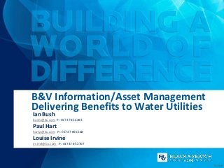
  • 1. B&V Information/Asset Management Delivering Benefits to Water Utilities Ian Bush bushi@bv.com P: 01737 856283 Paul Hart hartp@bv.com P: 01737 856568 Louise Irvine irvinel@bv.com P: 01737 852707 01/2013
  • 2. B&V Information Management Offering • 25 staff globally Automated property boundary definition • GIS, IT consultancy, application development & system integration experience • Experts in all aspects of data management • Strong spatial analysis focus • Asset information management expertise • Primarily work with utilities, local and national governments • Mandate to improve use of information management on B&V projects • Enabling clients to make better decisions Determining building height 2
  • 3. How does IM make a difference? 3
  • 4. Some of the Technical Services we provide • GIS/IM strategic, technical consultancy and training (e.g. GIS strategy, Needs assessment, technical due diligence) • Asset Management (e.g. Asset inventory, PAS 55 assessment, Asset investment planning, maintenance prioritisation, Asset data model design, Asset survey) • Evaluation analysis and management of all forms of geospatial data • Site and route planning • Geo-spatial analysis to support geo-engineering (e.g. cut & fill analysis, volumes, subsurface modelling) • Generation, analysis and visualisation of 3D models (e.g. surface models, watershed delineation, viewsheds, 3D fly-throughs) • Mobile mapping and capture systems (e.g electronic asset condition surveys) • Environmental services (e.g. support for habitat creation, EIA/SEA assessments, surveys, stakeholder consultation, planning) • Alternative energy assessments (e.g. site suitability for Biomass, Wave, Wind, Solar) 4
  • 5. More technical services... • Economic impact analysis • Flood risk management (e.g. Generation of ground models, interpretation of modelling results, economic appraisals, etc) • Coastal Management (e.g. Coastal zone surveys, Historic Trend Analysis, Beach profile change) • Geospatial statistics • Hydrodynamic and network modelling support (e.g subcatchment generator) • Landscape assessment (e.g photo-realistic impressions and photomontages) • Application development and system integration • Relational database design, development and management • Business process improvement • Web site, portal & dashboard design and development including map authoring • Geomatics services (e.g. Map making and reproduction, data capture, translation, metadata management, aerial map services) 5
  • 6. Benefits of our approach Standard, repeatable Where appropriate can rules agreed with include CCG client to meet representation in the specific needs Frequently a common approach, development stage in a delivery and outputs process Fast, reliable, consistent, accurate SWS have access to leading skill sets and experience High Able to support value, low business plan cost Can interface with client Frequently visible datasets e.g. unit outputs support cost database Outputs can be interpretation strategic or tactical – solutions are Uses a combination ‘drillable’ of public domain, client and derived data 6
  • 7. Clients we have delivered benefits to... 7
  • 9. Customer Analysis & Rollout Database Automated SubCatchment Generator Tool A comprehensive metering strategy to assist in the Division of network catchment area into smaller effective management of supply/demand balance model-able subcatchments 1 1 /02 /2 01 1 11 Pipeline Routing Optimisation Method Pollution Risk Assessment (PROM) Consideration of catchment risks and source Cost effectively and comprehensively consider the protection as an alternative to end of pipe supply options for a water resource strategy treatment Bathing Waters Investigations – South Coast Trunk Mains Risk Model Develop a risk model for Trunk Mains to identify and Storm water sewer systems identified as a major mitigate potential risk and drive the capital source of microbial contamination of bathing waters investment programme Serviceability Dashboard PAS 55 – Asset Management Benchmarking Providing access to ‘drillable’ serviceability business Assisting SEW to attain PAS 55 accreditation with the intelligence at all levels within the organisation Asset Management Insight System (AMIS) Project Risk Optimisation and Private Pump Station Strategic Planning Visualisation Engine (PROVE) Identification and survey strategy supported by innovative Visualise the risk and consequence for any time system period in programme horizon Flood Damage Economics Model (FDEM) Proactive Comm Pipe Replacement A GIS based approach to the flood risk economic A risk based approach to proactive maintenance assessment process 9
  • 10. Sewerage Infrastructure Service Outcome Schemes (from capital works programme, new developments) Strategic Studies Jobs (from work orders) Ad-hoc (redlining) APA Canal Asset Information Strategy Measures Analysis New Property Data File Strategic consultancy to improve the asset information Data Maintenance Procedures Other ACS Systems (Customer Billing ‘SAP’, Customer Enquiry, Identify the root causes behind an increase in management of a Romanian waters utility networks Unique Reference Management Work Order Management, Capital Maintenance/investment Planning, Monitoring, etc) pollution incidents Below Ground Data Area/Zones Customer/Property Above Ground Data (GIS Asset Database) (GIS Asset Database) Data Anaerobic Digestion (AD) Supply Chain 2012 Olympic Games Assessment Reducing the risk of asset failures during the Complex interaction between contributing factors and Olympics constraints Pressure Profiling Key Asset Security and Condition Surveys Identify key areas where pressure management Gap analysis of security and emergency studies should be performed for potential network measures at ‘at risk’ sites optimisation Mogden WwTW Upgrade – New Process Trunk Mains Database Stream, A central repository for asset, asset condition and Sludge Plant and Other Works capital works data for Trunk Mains Earthworks associated with the upgrade of the works Countryside Agency ‘Right to Roam’ Consistent Flood Warning Thresholds National mapping and consultation exercise to map To define the new flood warning thresholds for 3 open country and Registered Common Land in levels of flood impact for 180 Community Flood England Warning Areas (CFWAs) National Bio-fuel Supply Database Pipeline Studies in Chile Feasibility study for the transfer of water development a centralised online database of from the Pacific Ocean to a mining complex bio-fuel suppliers detailing the services they 200km inland and 3,500m above sea level provide 10
  • 11. Severn Estuary Tidal Power SEA Mapping Access Database v3 (MAD3) Strategic Environmental Assessment of tidal power Development of an Oracle Spatial 10g generation in the Severn Estuary, plus stakeholder Enterprise data repository, migrating all project engagement, energy yield modelling and engineering related and a number of corporate datasets design work. River Wandle Asset Inspection Survey Asset Intervention Database Manage huge volumes of capital investment Condition survey of the River Wandle and planning data to support the development of the produce a report providing detailed investment programme during the business plan information on every fluvial defence and review structure Cherry Cobb Sands Flood Compensation Deben Flood Risk Management Strategy Identify a suitable site for flood compensation The development of a long-term strategy to and undertake detailed design manage the flood defences for three of the Suffolk Estuaries Bedfont Court Flood Alleviation Offshore Tidal Power Detailed Design Model the tidal flows around the whole of the Flood compensation and earthworks UK covering the extent of the UK Continental volumetric calculations related to flood bund Shelf design near Heathrow Airport 11
  • 12. CONTACT DETAILS Ian Bush bushi@bv.com P: 01737 856283 Paul Hart hartp@bv.com P: 01737 856568 Information Management Louise Irvine irvinel@bv.com P: 01737 852707 12
  • 13. Customer analysis & rollout database (CustARD) • Need: Develop a comprehensive metering strategy to assist in the effective management of supply/demand balance • Challenge: Minimising impact on customers (e.g. Affordability) and cost of delivery, protecting company revenue, maximising engagement with stakeholders, upholding fairness and equity • Solution: A geo-database decision support tool which assists in managing the customer relationship • Estimates post metering consumption • Allocates attributes e.g. income, property type to individual households • Accurate and fully auditable Customer impact covering company area • Enables customer segmentation and profiling, Information Management and a focussed service offerings • Benefits: Has meet challenges and produced a optimised metering programme • An 6 figure CAPEX saving and 10% uplift in optants (customers opting to install a meter) • Improved relationship with regulator • Peer reviewed and considered most advanced and comprehensive customer analysis tool in the UK water business • Other challenges can benefit from CustARD 13 Customer impact Dashboard
  • 14. Automated SubCatchment Generator Tool • Need: Most time consuming and difficult task is defining the catchment areas and the percentage of impermeable surfaces when building a sewer system network model (e.g. For Drainage Area Plans) • Challenges: Division of complex network catchment into smaller manhole based subcatchments • Traditionally a time consuming manual task • Complex set of rules to define divisions and determine impermeable areas • Solution: Tool created to use set inputs and apply hierarchical set of business rules to generate model Intuitive tool input screen ready subcatchments • Analysis is undertaken to determine all roofs, roads, paths, property boundaries and any other semi/ Information Management impermeable areas • Attribution – areas are automatically measured, and codes assigned creating a ‘network model ready’ file • Benefits: Time savings of >80% - the model rather than the modeller generates subcatchments • Improved modelling –more detailed catchments providing a better representation of run-off • Consistency – Judgement is removed so all catchments based on the same rules 14 Subcatchments
  • 15. Pipeline Routing Optimisation Method (PROM) Automated Reporting • Need: How to cost effectively and comprehensively consider the supply options for a water resource strategy • Challenge: Complex landscape, many constraints, limited budget, lots of alternatives, equal consideration • Solution: GIS tool determines best route • Considers all geotechnical, human and environmental constraints at the same time • Weighting and combining 50-70+ decisional datasets • Any number of start locations/options • Benefits: Significant time and cost saving for • Automatic reporting: profiles, schedules, maps Information Management route planning – typically £25 to£40k • Minimizes capex and opex (e.g. £250K) • Provides quantitative information to support due diligence • Quickly compare the merits of one route with another • Use of expert resources as verification and not for whole assessment process • Now used in other areas of the business (infra. Planning, price review) • Reusable on whole utility area 15 PROM Least Cost Database
  • 16. Pollution Risk Assessment • Need: To comply with it regulatory obligations (WSR and WFD) Thames Water need to understand the risks of pollutants entering the water supply chain. • Need to devise a catchment based risk assessment methodology for both its surface water intakes and its groundwater abstraction points. • Challenges: Large amounts of disparate data across a large geographic area, poor data accuracy, complex interaction between natural surfaces and sewer/stormwater networks Catchment Risk Map • Solution: GIS-based quantitative • Benefits: Provided TW with a Intakes Watercourses assessment of catchment risks and source protection Information Management simple risk classification to identify high priority water • Hazard  Pathway  Receptor sources approach • Improved data and • Risk-based approach included catchment understanding severity, impact and likelihood • Provided tools to undertake a factors proactive and collaborative • Quantifiable, repeatable and approach to understanding auditable method for catchment and mitigating against risk assessment catchment risks Catchments • Immediate and effective due diligence support Simple Surface Water Pathway 16
  • 17. Trunk Mains Risk Modelling • Need: Develop a risk model for Trunk Mains to identify and mitigate potential risk and drive the capital investment programme • Challenge: Modelling probability and consequence of failure individually for a large number of assets (100,000+) • Calculating risk using a common framework approach allowing different types of consequence to be compared with each other • Incorporate potential solutions, including costs and benefits of implementing the solutions to allow investment planning Risk displayed spatially • Solution: A database decision support tool which • GIS analysis to model flood risk from calculates risk and cost-benefit producing a list of simulated bursts across the network prioritised assets • Network analysis to determine supply Information Management impacts from simulated bursts • Benefits: Has met challenges and produced a commended Trunk Mains Risk Model • £100m+ investment case supported and justified using the risk model • Investment case would not have been approved by the regulator without the model • Considered the most advanced risk model for Trunk Mains in the UK • Forerunner for other risk models 17 Risk Model Dashboard and Risk Profile
  • 18. Bathing Waters Investigations – South Coast • Need: Stormwater sewer systems identified as a major source of microbial contamination of bathing waters in Bognor Regis, Worthing, Hastings and Broadstairs • Challenges: Identify the assets that discharge through outfalls close to the bathing waters • The management, analysis and distribution of: • large asset datasets (of variable quality) • Significant amounts of monitoring data (e.g. 1,968 samples in a 6 hour period) Sample IAS Survey Plan Stormwater Outfall at Hastings • Manhole, CSO, pumping station, short • Benefits: Has an term flow and impermeable area surveys understanding of the • Solution: Assess bacteria loads; propose contamination levels remediation measures for surface water within each sub- Information Management sewerage systems catchment/outfall • Geodatabase to provide a centralised data • Demonstrated to the repository for analysis and distribution Regulator the removal • Automated routines to format incoming of all mis-connections data will improve the bathing water quality • Automated routines to clean data for • Centralised, collated network geodatabase for version hydraulic modelling control and data issue • Automated extrapolation of sample • Automated bulk map IAS surveys to whole catchment production coverage routines 18 Sample Monitoring Location Plan
  • 19. Serviceability Dashboard (SERVIZ) • Need: To clearly communicate serviceability outcome measures suitable for all levels within the organisation • Challenge: To provide clear visibility of business intelligence at a various levels of detail (drillable data) • Large amounts of disparate data residing in various systems, changing over time • Avoiding complex system integration • Spatial correlation of assets • Solution: Esintial Business Intelligence Platform • Supports a spatial view alongside business KPIs Individual Burst Detail and metrics • Benefits: Uses SEW existing infrastructure – • Supports massive volumes of data from Information Management minimal infrastructure costs disparate sources • Easy to maintain and grow. Maintenance/ reporting productivity efficiency Serviceability Dashboard • Continual/timely evidence of serviceability performance in an enterprise wide, stable, easy to use and non-proprietary environment • Easy view of “Strategic” (Analysis/Planning) “Tactical” (Operations) level data in a single application 19
  • 20. PAS 55 - Asset Management Benchmarking • Need: Assist SEW in attaining PAS 55 accreditation • To demonstrate good practice Asset Management • Identify improvements in both efficiency and regulatory performance • Challenges: Existing tools for assessing PAS 55 capabilities were hard to navigate and complicated • South East Water at the start of the PAS 55 journey • Many elements were not in place • The rigid structure of these tools made effective recording difficult, and subsequent reworking and collaboration between assessors was time- • B&V created an assessment tool that consuming. enabled rapid navigation and easy data capture of asset management capabilities Information Management and supporting evidence • Solution: South East Water sought B&V’s • Benefits: Successfully attained accreditation experience in Asset Management benchmarking as Institute-of Asset Management endorsed • Enabled B&V to provide SEW with an assessors against the PAS 55 standard immediate score for each PAS 55 element to identify high priority improvement requirements • Improved data and evidence capture • Immediate feedback to assessors and SEW ensured clarifications and challenges were tackled instantly 20
  • 21. Project Risk Optimisation and Visualisation Engine (PROVE) • Need: To minimise the risk of interruption to customer supply resulting from the cumulative project impacts of their capital works programme (new mains, rehab, swabbing , cleaning, site works) • Challenge: Easily understand overlapping temporal and geographic project risk (probability, consequence), limited budget, short timeframe, central programme management • Solution: Engine directly connects with programme software (e.g. MS Project) • Customised programme to support additional reporting (e.g. Impacted DMA’s) • Calculates consequence using sensitive customer MS Project Input Information Management data • Represents risk temporally in 3 dimensions in a geographical context (in Google Earth) • Benefits: Can visualise the risk and consequence for any time period in programme horizon • Quickly understand the complexity of the all the influencing factors • Provides an easy means to iteratively evaluate and mitigate risk Google Earth Output 21
  • 22. Private Pump Station Strategic Planning • Need: Change in legislation forcing utilities to adopt PPS by 2016. Need to determine best adoption strategy • Challenges: Identifying number and location of PPS, Establish cost of upgrading PPS to serviceable condition, collection of disparate intelligence • Solution: Identification and survey strategy supported by an innovative system • Comprehensive information sourcing approach from all stakeholders (362 contacts from 106 organisations) • Survey a sample (100) unadopted PPS to assess condition and a further 500 location surveys • Centralised spatial database to hold all survey, contact and PPS information Information Management Intelligent electronic forms Ruggedised tablet PC • Database accessed using GIS, InfoPath and Access with automatic reporting • Benefits: Investment requirement known to bring up to SW serviceable standard • Extensive audit trail and information source developed useful for further work • Robust repeatable process Automated, map based progress reporting 22
  • 23. Flood Damage Economics Model (FDEM) • Need: Flood Strategies key consideration is the Spatially representing damage costs economical appraisal of a number of flooding scenarios. 1:5 Cost/Benefit ratio requirement • Challenges: Vital to consider the economics (capital, opex, whole life cost, operational /embedded carbon impact) of all options at the best possible level of detail • More detailed digital data is becoming available at a national and global level • Solution: We have developed the Flood Damage Economics Model (FDEM), allows focus on key areas quickly using spatial oriented queries, reporting and visualisation • Fully scalable and is capable of supporting Information Management appraisals of small towns or entire regions or even • Economics calculated, reported and stored entire nations at the property level • Entire decision process can be thematically • Tool based consistent repeatable method mapped • Benefits: Improved property inclusion and classification resulting in more accurate appraisal • Estimated 25% efficiency saving over previous method • Quickly can identify and quantify problem areas Spatially represent % contribution to overall total • Robust audit process better 23 supports due diligence
  • 24. Proactive Communication Pipe Replacement • Need: Funding to invest in the proactive maintenance of communication pipes (service connections) but no robust and auditable method for determining where to invest • Challenges: Large disparate collection of asset performance data • Balance of depth of analysis vs tight budget • Significant data gaps • Difficult to create work packages • Solution: Modelling risk to better target comm pipe replacement (probability & consequence of failure) • Using known failures (work orders), soil type, Scheduled work pressure, property data to create cohorts Information Management • Hot spot analysis to identify clusters of poor performing assets • Benefit: Schedule of proactive communication pipe work now included in AMP 5 capital maintenance programme • Creation of sensible work packages (i.e. Cost effective) at street level • Improved performance based data (infilling) • creation a spatial dataset to represent the communication pipes for entire company area 24 Density Analysis
  • 25. APA Canal Asset Information Strategy • Need: Strategic consultancy to improve the SimpleJunctionFeature asset information management of ACS water distribution and sewerage networks WaterFacility • Challenges: No Asset Information Manhole NetworkStructure Meter Hydrant Pump Valve Management Strategy in place • Extensive data management issues SamplingStation ConnectionPoint Fitting StorageReservoir SystemValve ControlValve • Lack of awareness within executive A Data Model • Solution: Development of Asset Information Strategy: Schemes • Short, medium, long term roadmap (from capital works Strategic Jobs Ad-hoc programme, new developments) Studies (from work orders) (redlining) • Full data, organisational and technology gap analysis New Property • Corporate data model Information Management Data File Data Maintenance Procedures • Data collection/maintenance strategy Other ACS Systems Unique Reference Management • Organisational change (Customer Billing ‘SAP’, Customer Enquiry, Work Order Management, Capital Maintenance/investment Planning, Monitoring, etc) requirements • technology review Below Ground Data Area/Zones Customer/Property /recommendations. Above Ground Data (GIS Asset Database) (GIS Asset Database) Data • Benefit: Executive support • New Asset Management Group formed with roles and Data collection process responsibilities • Understand what is needed 25 • Data improvement programme underway
  • 26. Sewerage Infrastructure Service Outcome Measures Analysis • Need: Serviceability measure outcomes of SWS Sewerage Infrastructure (SI) was ‘marginal’. Pollutions incidents increasing • Challenges: To link pump station performance, blockage movement and/or changing demographics as cause for increasing pollution incidents • Disparate, large amounts of, and poorly recorded source data • Solution: Integrated service using network modelling, GIS database analysis, mapping and asset management expertise • Analysed a complex array of physical and performance based Sewerage Blockage asset data • Built a number of spatial models to analysis the strength of the correlation between source data and pollution incidents Information Management • Benefit: Identified a number of operational and strategic recommendations to improve SWS’s serviceability measures including: • a new indicator for assessing pumping station deterioration • an early warning tool to for poor pumping station performance. • Defined the parameters with which to describe a sewer blockage movement. • Cost effective automated blockage 26 Serviceability reporting movement tool now in place
  • 27. Anaerobic Digestion (AD) Supply Chain Assessment - National Non-Food Crop Centre • Need: To meet the UK challenge to accelerate the uptake of AD, this report contributed to the analysis of different options in terms of inputs, outputs and technology options in order to identify the most effective delivery of AD from an environmental and economic point of view, and optimal locations for AD plants. • Challenges: Complex interaction between contributing factors, variable data quality for the different constraints available at different scales, national scale analysis, limited budget • Solution: GIS as a criteria based decision support tool to determine site suitability across the UK • Considers contributing factors simultaneously • Availability of fuel source i.e. manure and/or food waste • Proximity to land suitable for the digestate (fertiliser) e.g. agricultural land Information Management • Proximity to the gas grid as a destination for the biogas • Proximity to the electricity grid as a destination for the processed biogas • Benefits: Centralised geodatabase, a single source of all information: • Source data, weightings and results • Automated routines and models to perform site suitability calculations • Summarised complex information relating to Example UK site suitability map AD development Site Suitability Map • UK AD site suitability map 27
  • 28. 2012 Olympic Games • Need: Prepare the UK’s largest clean water supplier for the world’s biggest sporting event • Challenges: Large disparate collection of asset performance data with significant data gaps • High profile project with a tight schedule • Resistance of local authorities to additional works • Solution: Develop an algorithm to identify burst/leakage risks to the Games based on proven methods within the business. • Manually validate results to provide defensible, necessary projects for monitoring and rehabilitation. Information Management • Warehouse all data to provide a central source for other client business interests (waste, planning, modelling) • Benefit: Comprehensive project identification format recognisable and acceptable by local authorities which identifies and mitigates potential risks to Olympic sporting events and patrons • Brand resilience during a high profile event • Data availability and consistency across the business 28
  • 29. Key Asset Security and Condition Surveys • Need: Gap analysis of security and emergency measures at ‘at risk’ sites • Challenge: Undertook 136 security surveys of Southern Water assets, and a further 200 condition surveys • Solution: Site visits optimised to improve efficiency • Data integrity maintained using centralised spatial database • Field data captured on GPS enabled PDA • Location based data capture e.g. fence lengths Site photos linked to assets and recorded in database • Onboard camera provided GPS tagged photos automatically referenced to survey record • Benefits: Use of PDA and forms improved Information Management data capture methodology • Desk based post survey validation and reporting using easy to use intelligent electronic forms • Viewed and edited by the multiple team members • Edits made in one application are immediately visible in another • Digital capture eliminated the requirement for Integrated field and desk based approach post data entry and the associated potential for errors. 29 • Automated map and report generation
  • 30. Pressure Profiling • Need: Identify key areas where pressure management studies should be performed for potential network optimisation • Challenges: Massive analysis area, 7,600 km2 • Client required a visual, non-numeric result • Complex data sets with tens of millions of records • Solution: Simplify data into manageable pieces • Create 3 dimensional height profiles for critical assets • Identify areas of high tall building density (areas where buildings have a higher than baseline pressure need due to elevation) Information Management • Correlate high density areas with critical asset profiles • Benefit: Reduction of client’s costs for studies. • Client can focus studies on areas most likely to benefit from pressure management • Simplified, visual representation of complex numerical data allowing quick identification of areas where pressure management schemes may be created or modified 30
  • 31. Mogden WwTW Upgrade – New Process Stream, Sludge Plant and Other Works • Need: As part of the £100m contract to upgrade Mogden WwTW significant early works involved the shifting of a large earthworks embankment (up to 8m in height and over 300m in length), which has been relocated to the west to provide space for the new effluent stream. • Challenge: To tie the • Solution: A GIS database to new structures into the collate the design information existing surface and • Integrated data management generate the new • Provision of a single auditable design surface. data source for the earthworks • To provide detailed calculations earthworks (cut and fill) volume calculations. Section View: Existing to Design Surface Comparison Plan View: Existing to Design Surface Comparison Information Management • Benefits: Innovative use of earth reinforced embankments in place of RC retaining walls • Only a quarter of the overall muck shift quantity (380,000m3) will need to be disposed of off-site (3000 tonnes will be reused on site) • Significant reduction in lorry movements through local communities. • Provision of visual results of the earthworks calculations 31
  • 32. Trunk Mains Database • Need: Centralise all trunk related data/activities to improve the day to day management of Trunk Mains and provide better evidence to support future investment plans • Challenge: Initial collation of a large volume of disparate data in a number of different formats from across the business • Creating the business as usual processes to ensure the database is maintained with the most current data • Solution: An auditable database & reporting support tool enabling the storage, reporting and export of Trunk Main asset & performance data A wide range of Trunk Mains related data is maintained in the TMD • Positioning of Asset Management as the central • Benefits: Presents one version of the truth contact for all information related to Trunk Mains giving greater confidence • The daily update of asset & activity data to provide • Supports ‘due diligence’ by providing an Information Management the business with up-to-date information auditable history on all trunk main activities • Provides a user-friendly environment to quickly access & report Trunk Main information • Superseded all existing leakage trackers to become the primary reporting tool on all Trunk Main leak repairs • Primary source of data for PR14 Trunk Main investment case 32 Capital work progress monitoring and assets displayed spatially
  • 33. Countryside Agency ‘Right to Roam’ • Need: Right of Way Act placed a duty on the Countryside Agency (now Natural England) to prepare maps for all Open Country & Registered Common Land in England • Manage the complex legal process of mapping and public consultation • Challenge: Undertake a politically sensitive mapping exercise • Collate and interpreted over 360 different datasets including aerial photography for the whole of England • Perform national consultation exercise with stakeholders Online consultation map and the public • Solution: Mapping Access Database (MAD) was created which holds in excess of 3 million records and over 650Gb of geographic data. Information Management • First use of web based mapping as part of a national statutory consultation • 1,700 site visits to verify comments • Benefits: 0.9 million ha of qualifying habitat mapped now Open Country • Comprehensive mapping system used by 90 operators • Successful consultation exercise • 28,000 comments on 36,000 parcels of land assessed • Website: 35 million hits; 600,000 unique visitor Consultation / comment screen • 3 million unique map views 33 • £15million, 5 year project completed on time and budget
  • 34. Consistent Flood Warning Thresholds • Need: To define the new flood warning thresholds for 3 levels of flood impact for 180 Community Flood Warning Areas (CFWAs) across South East England • Challenges: Large datasets at a regional scale, disparate data sources, multiple/overlapping data, poor data accuracy, a significant amount of anecdotal and non-digital, incomplete gauge hydrometric records Integrated approach to data with GIS • Solution: Review of all • Integrated approach to modelling available information and GIS to determine flooding • compilation of a mechanisms and threshold levels centralised geodatabase using hydraulic models, hydrometric which could be used for data and topography spatial analysis, rapid • The production of catchment level Information Management tabular querying and reports including for each CFWA the map production details of the threshold derivation, Historic river level records the data used and the assumptions made • Benefit: Provided the Environment Agency with a more consistent approach to flood warning thresholds • Results not only delivered back as report and maps but also in a single geodatabase for seamless integration in to their corporate GIS system • Comprehensive review of hydraulic models, river flow and level records performed and 34 Example threshold derivation from flood outline delivered as an additional report
  • 35. National Bio-fuel Supply Database(NBSD) • Need: To create a national centralised online resource for Bio-fuel suppliers NBSD Home Page • Creation of a good vehicle to promote bio-fuel in the UK • Multitude of poor ineffective biomass related websites • Challenge: Maintained primarily by the suppliers and self administered by client (e.g. Authorisation capability) on a limited budget • Poor bio-fuel availability and data projection issues • Solution: To develop a centralised online database of bio-fuel suppliers detailing the services they provide • Custom Google mapping interface with supplier • Notification, review and acceptance locations and multiple filtering/search tools systems in place for the NBSD administrators • Self registration system for the suppliers, allowing them to add their business and geographic location • Data programme to capture supplier Information Management details information • Benefits: National central resource now available • More comprehensive bio-fuel supplier detail available • Locate bio-fuel suppliers easily • Self registration as a bio-fuel supplier and add supply locations and business details Supplier location • Minimal administration registration costs 35
  • 36. Pipeline Studies in Chile • Need: Feasibility study for the transfer of water from the Pacific Ocean to a mining complex 200km inland and 3,500m above sea level • Challenge: Remote location means limited existing data availability • Multiple contractors have created data not immediately compatible • Solution: Single data model consolidated all pertinent data into standard format Pipeline and • Defined single chainage start location to easement corridor ensure data consistency • Use of Google Earth and NASA data to ensure support site familiarisation Information Management • Benefits: Data standards improved input, reduced errors and eliminated data translation or manipulation • Online data and viewing tools supported team in review potential routes in some detail • Client meetings highly visual with on- screen detailed analysis of route selection process Pipeline profile 36
  • 37. Mapping Access Database v3 (MAD3) • Need: Incorporate all finalised open country project data into the Countryside Agencies business as usual process • Create and populate the Corporate spatial repository for the Countryside Agency • Challenge: Account for disparate databases, in many formats, with conflicting data models. This included: • All data within the existing MAD2 SQL Server database, over 3.5 million interrelated records in 50 tables MAD3 data model • Two country-wide versions of MasterMap • Solution: Design, develop and populate an (topographic data) Oracle Spatial 10g Enterprise data repository, • All statutory spatial datasets created during the migrating all project related and a number of original four-year mapping project corporate datasets • 30 project or corporate related datasets • Capturing data requirements and Information Management implementation within an efficient relational • Migration must be carried out without impacting on database model. any of the statutory project data; even a mm-sized • Designed to ensure it would accommodate the shift in certain datasets was unacceptable future growth requirements Multiple datasets • Benefits: Creation of a 1TB spatially enabled corporate repository capable of supporting the open country business process • Migration and translation of over 100 disparate datasets into a central accessible environment • A comprehensive testing programme was developed in order to validate the migrated data and meet the high quality assurance (QA) 37 requirements
  • 38. Severn Estuary Tidal Power Strategic EA • Need: Inform a decision on whether the Government could support a tidal power project in the Severn Estuary. • Perform the environmental aspects of a feasibility of tidal power generation in the Severn Estuary • Challenge: Substantial package of specialist environmental impact research, modelling and fieldwork for a range of tidal power options • Complex modelling scenarios over a large area including multidimensional hydrodynamic, geomorphological and ecological impact models. The Severn Bridge • A substantial stakeholder and consortium engagement programme. • Solution: Strategic Environmental Assessment (SEA) – 16 topic-based assessments • Data Management and Governance – creation of central project geodatabase and a seamless topographic surface Information Management from 4 digital data sources • Multi-disciplinary Studies – tides, waves, sediment movement, morphology, habitats, birds and water quality • Tidal Yield Modelling – scheme optimisation Combining LiDAR, Bathymetry and Local Surveys • Benefit: A robust, integrated quantitative impact assessment, providing objective, informed evidence of effects. • Energy yield modelling, based on unique expertise provided a cost- effective approach. • The programme of engagement ensured acceptance of the outputs generated, ensuring value for money. 38
  • 39. River Wandle Asset Inspection Survey • Need: Fill gaps in knowledge of assets to better support asset management planning strategy • Undertake a condition survey of the River Wandle and produce a report providing detailed information on every fluvial defence and structure • Challenge: Visit over 1,000 assets on either side of a dense, urban, 15km stretch of the Thames tributary • Complete detailed survey of each asset in line with Environment Agencies NFCDD dataset Asset inspection via GPS • Solution: Surveying was undertaken by a two person enabled PDA engineering team experienced in asset condition inspections • GPS enabled PDA used for digital field capture • Drop down lists and auto-population to improve capture • Custom tools creates to create sequenced map Auto generated map and Information Management photo sheets and photo sheets with descriptions for each asset • Benefits: Estimated 15% efficiency saving • Use of PDA allowed better decision making in the field based on existing and supplementary GIS data being instantly available • GPS tracking to better support orientation and the location of assets • Embedded customised forms enables more efficient data capture and validation in the field data • Reduced post processing back in the office • Custom tool created to generate over 1,000 unique asset photo table descriptions 39
  • 40. Asset Intervention Database • Need: Interpret and analyse huge volumes of capital investment planning data to support the justification and prioritisation of the investment programme during the business plan review • Challenges: Take account of all programme drivers (Capital Maintenance, Quality, Supply and Demand, and Enhanced Service Levels) • Link disparate investment model/plan outputs • Solution: A well structured central database to hold all investment planning outputs • Benefits: Line of sight from investment • An efficient and easy to use reporting models to delivery programme mechanism that enables SEW to use a wide • Identify potential efficiencies through range of querying criteria (e.g. drivers, time, site, overlaps in the programme (time and asset type, geography, etc) for interventions at spatial) Information Management any site at any point in time in programme • Identify enabling works that could take • Grouped work by site and by time period to place ahead of schedule facilitate the development of a delivery • Enables visualisation of long term and programme constantly evolving plans • Rapid auto-generation of Project Initiation • Provides local/regional/strategic level Documents for capital delivery reporting to support decision making • Included significant detail on the environmental • Maintains current Asset Life and planning implications of each project Cycle Plans – track business plan progress • Pipe level detail • Clear definition of their years 1 and 2 AMP5 Investment Programme 40
  • 41. Flood Risk Management Deben Flood Risk Management Strategy – Stage 1, River Deben, Suffolk • Need: Prompted by growing concern over several areas in Suffolk that are susceptible to flooding, the Environment Agency commissioned the development of a long-term strategy to manage the flood defences for three of the Suffolk Estuaries • Challenge: Complex tidal system with offshore undersea banks impacting tidal prism • Large, low lying and largely uneconomic flood envelope Martello defence tower • Active local action group • Solution: Utilised Black & Veatch’s Flood Damage Economics Model (FDEM) as the basis of its economics assessment. • Team of surveyors captured existing defence line and over 1,000 property thresholds. Each measurement was interrogated against ‘off-the-shelf’ topographic data and combined to created a the most detailed, seamless DTM of the estuary to date. • Benefits: 40 options were effectively assessed on 1,700 Consultation mapping at risk properties and environmental receptors • High-level cost-benefit assessment for all flood cells and options to bring focus to the stage 2 detailed assessments • Enhanced understanding of estuary processes and the impact of managed retreat • Workshops held with the Deben Estuary Partnership. including on screen 41 demonstrations of the risks and potential mitigations being considered

Notas del editor

  1. Time & Cost – one example is the building of systematic models to improve productivity.All overlaping examples in reality.Quality – We take data and perform analysis on it to fill gaps using surrogate information etc.Dec support – We turn data into ‘information’, i.e. Where is the best most cost effective place to route my pipeline from a capex and opex view point. Where are the most critical areas in my treatment process. What is the monetised consequence of a trunk main failing.Understnding. Using the spatial domain to improve understanding. Communication – collaboration, sharing of knowledge.
  2. Other Challenges can Benefit from CustARD: Affordability Profile and Cohorts, Tariff Development, Debt Management, Developing Retail Competition, Other programmes, PR Programmes and Targeting,Water efficiencyCustomer relationship management Metering strategy- Financial management
  3. Time saving based on typical 5 day spend on doing this using traditional methods. This has been reduced to 1 days checking and revising. Uses Ordnance Survey’s MasterMap and wastewater network attributes to automatically create seamless catchments that are line with WaPUG (CIWEM's Urban Drainage Group) guidelines. The tool incorporates the following:Analysis is undertaken to determine all roofs; roads; paths; property boundaries and any other semi and impermeable areas.Catchments are identified based on proximity to a network asset, then tested to ensure connectivity. All unconnected catchments are reassigned to a neighbouring catchment ensuring model compliance. Within the output data key attributes are populated such as impermeable area (ha) and area take off (ATO) codes.Subcatchments and Area Take Off’s are exported ready for review prior to direct import into network modelling software.
  4. Trunk Mains Risk Model for Thames Water.Created with Thames Water and designed to support investment decisions during PR09 but now being taken forward and used in day-to-day business to support operational decisions and schedule workBased on common-framework approach – combines probability of failure and consequence of failure. Assesses a number of different consequences including internal flooding, interruption to supply, low pressure, health and safety.Built using an MS Access database – this is so that it’s easy for others to understand and can be handed over easily (the functions are stored in “Queries” not VBA to keep the database simple for others to understand.This is a re-usable model that allows risk scores to be calculated based on different scenarios. Over 1.5GB of data is processed during every “model-run”.The output is a list of trunk main pipes prioritised by risk of failure. This is now being used to target and schedule work for AMP5.
  5. significant amounts of monitoring data (82 auto-samplers, 98 long term flow monitors and 24 rain gauges, such that a single rainfall event could collect andanalyse up to
  6. Southern Water Private Pump Station Strategic Planning Support – Part of 2016 Private Pump Station adoption initativeTask to: Identify all unadopted pump stations within SW’s operating areaConfirm details of sites (owner, maintainer etc)Survey a selection (50-100) to determine condition relative to SW and Ofwat specificationsReport findings to support SW’s adoption strategyHow this was achieved:Single spatial database storing all pump station locations, survey information, contact informationAccessed by ArcMap (for GIS users) and Infopath forms (whole team)362 contacts at 106 organisations were contacted to ascertain pump station locationsCorrespondents with contacts linked to spatial site object using common reference within single db (very joined up)PS locations also identified through web form, SW data mining and third party datasets such as EA consented dischargesSite locations reviewed to determine suitable ‘survey clusters’ which were then targeted for survey on a single day optimising site timeOn a ‘survey day’ survey side of database ‘checked out’, loaded onto ruggedised, GPS enabled 7” tablet PC and populated using Infopath form on siteOnce back in office data checked back in to central database and reviewed using same Infopath formWeekly reporting of progress through site visit programme, maps and correspondence numbersAutomated reporting using maps to show all sites, new sites, surveyed sites etcQueries to determine number of calls, sites resulting from calls etcAsset ManagementStrategy development
  7. OlympicsAutomated failure-to-pipe matching process. Manual validation of mains repair data to improve it (remove duplicate records and ensure correct spatial matching to pipes). Then this data was used to determine mains with high failure rates around Olympic Venues or on the Olympic Route Network (and Embargo roads). Plans for all locations were drawn up and delivered to capital delivery etc.Picture is an example ofthe type of output given to Capital Delivery and local authorities to drive projects forward. Other picture is the data example. Data created by Black and Veatch was used across the business as the starting point for other Olympic analyses (waste, resilience, modelling).
  8. Southern Waters SEMD Site Security Surveys – To undertake 136 security assessments and make recommendations including the cost of those recommendationsSites plotted in Google Earth to support route planning / provide overview before visitCustomised ArcPAD forms loaded onto GPS enabled PDA along with background data for each site10 different forms used depending on what was captured – forms included drop down lists, auto populating fields and tick boxes where possiblePDA captured location of each borehole survey, fence locations, specific recommendations to 2-5m accuracyPhotos also captured on-board and automatically tagged to surveyData returned from field, checked into central spatial database and immediately available on map and via infopath formSurveyor then used Infopath to review field notes and amended where necessary (e.g. converting short hand to full English, adding photos from other sources and making recommendations)Infopath information viewed by estimators to support cost estimations of work – single source of information and photos really helped cost projectInfopath also used as reporting tool with forms being exported directly into report appendiciesSuccess of integrated approach led to PM of Building condition Survey approaching us – To undertake 130 asset condition surveysVery similar, visit sites, complete, form, review form, make recommendations and cost estimates, report findingsMany of the sites on each survey overlapped so single site list used and data fed into same database
  9. Pressure ProfilingPressure management reduces failure rates and increases asset life and return on investment. By bringing together data sources from across the business (we used height data from waste manhole covers to refine our elevation models) we were able to build profiles for trunk mains in areas where tall buildings and principle mains converged. Top right picture is the convergence of buildings, height, and asset data. Bottom left is the 3D image with the asset profile.
  10. Trunk Mains DatabaseA database that stores condition and performance data of Trunk Mains. (combination of DST & asset register).Helps AM understand where the TM assets are, what condition they’re in, the costs associated with maintaining the assets, and helps schedule future works.Improves AM targeting of poorly performing assets and records the decisions made. An audit history of why a leak is not being repaired is as critical to understand as why a leak is being repaired.An interim solution to WAMI – Prototype. When WAMI was conceived the elements related to tracking of trunk main leaks from detection to repair and storing the results of testing was not designed into WAMI. Other elements such as the holding of vital Chamber and Monitoring locations were also not included in WAMI. The aim of TMD is to be an interim solution setting up and defining the processes and information that needs to be stored so that WAMI can take it over in the future.
  11. The Countryside and Rights of Way Act 2000 placed a duty on the Countryside Agency to prepare maps of all open country (mountain, moor, heath or down) and registered common land (RCL) in England. This project provided the first statutory digital map showing areas in England where the public has the new right of access.