SlideShare una empresa de Scribd logo
1 de 23
RIVER INTER LINKING – IS IT REALLY A MIRAGE ? 
K.Periasamy M.Tech ( Chem Engg) 
Chennai -97 
******* 
Introduction 
River Inter Linking scheme in India has a fairly long history. During British era, Sir Arthur Cotton, a 
Colonel proposed the linking of major Indian rivers in 1858, and it was not taken up seriously then 
since the British gave priority for Railway links. In 1970s, Dr.K.L.Rao, the then Irrigation Minister, 
who himself is a water expert proposed the National Water grid for transferring surplus water from 
northern rivers to the water deficit areas of south India. During this period many irrigation schemes 
involving some Intra-State river link projects were executed, though this Inter - State projects could 
not be taken up for financial reasons. In late 1970s, Captain Dastur a pilot, proposed the concept of 
Garland canals, one for the Himalayan rivers and the other for the Peninsular rivers. Ultimately, all the 
schemes aimed at transferring the surplus water from one region to the other. 
In 1980, the then government took a serious initiative and came out with the National Perspective Plan 
which proposed the Inter-Basin River water transfers. It set up the National Water Development 
Agency( NWDA) in 1982. NWDA took up the study of various links and completed Feasibility Report 
( FR) of 30 Links, 16 in Himalayan region and 14 in Peninsular, with one of them as an alternate. 
In response to a Public Interest Litigation filed based on the speech by Dr.Abdul Kalam, the then 
President of India, the Supreme Court gave a verdict in 2002 that Central Government shall constitute 
an Empowered Committee for speedy implementation of the River Inter Link Projects. It set a deadline 
of 2016 for completion. The Government appointed an Empowered Committee under the Chairmanship 
of Suresh Prabhu, the then Power Minister and studied the various Links. But subsequently nothing 
came off. 
However, in response to the Supreme Court verdict, there were lot of criticisms on various grounds 
like, environmental impact, forest area loss, human displacement, objection by some State 
Governments, very high investments, Judicial activism, etc. Due to the visibility of these arguments by 
way of high decibel discussions in the generic media, supported by certain NGOs and vested foreign 
interests, one tends to think whether the River Inter Liking Projects will ever be implemented in India 
or will these projects continue to remain as a mirage !
The lack of serious initiative from the Central Government even after 12 years of this land mark 
judgment adds ammunition to these criticisms. Out of the 29 Links, just one Link, Ken-Betwa in 
Madhya Pradesh has been cleared for implementation recently after almost 12 years of the judgment. 
Just two other Links, Damanganga-Pinjal link and Par-Tapi-Narmada link have been taken up for 
preparation of Detailed Project Reports(DPRs). 
The Inter Basin River water transfer schemes have been extensively studied over many years by experts 
from all discipline from all angles. Not just by Civil engineers and Agricultural experts. They have 
decisively concluded that technically it is very much possible to execute these projects with a guarantee 
for the required rate of return on investment and with least environmental impact. No one wants to 
mislead by saying that there will be no environmental impact. 
Let us analyse the pros and cons of these projects in simple terms with an open mind and understand 
them in the right perspective. With a clear understanding of the subject let us drive and support the new 
Central Government for implementing it in right earnest so that all the Links are completed in 15 to 20 
years, if not earlier. 
River Inter Linking Projects 
The River Inter Linking scheme, alternately called as Inter Basin River Water Transfer scheme, has two 
Components : A. Himalayan Component. B. Peninsular Component. 
The following are the List of Links finally approved by the National Water Development Authority and 
Central Water Commission under these two components. 
A. Himalayan Component (Figure- 1) : 
1. Kosi – Mechi 
2. Kosi – Ghagra 
3. Gandak – Ganga 
4. Ghagra – Yamuna 
5. Sarda – Yamuna 
6. Yamuna – Rajasthan 
7. Rajasthan – Sabati 
8. Chunar – Sone Barrage 
9. Sone Dam – Southern Tributaries of 
Ganga 
10. Brahmaputra – Ganga ( MTSG ) 
11. Brahmaputra – Ganga ( JTF ) – 
(Alternate for 10 ) 
12. Farraka – Sunderbans 
13. Ganga – Damodar – Subernrekha 
14. Subernrekha - Mahanathi
B. Peninsular Component (Figure-2) : 
1. Mahanadi ( Manibhadra) – Godavari 
2. Godavari ( Inchampalli ) – Krishna 
(Nagarjunasagar ) 
3. Godavari ( Inchampalli ) – Krishna 
( Nagarjunasagar Tail Pond ) 
4. Godavari ( Polavaram ) – Krishna 
( Vijayawada ) 
5. Krishna ( Almati ) - Pennar 
6. Krishna ( Srisailam ) - Pennar 
7. Krishna ( Nagarjunasagar ) – 
Pennar ( Somasila ) 
8. Pennar ( Somasila ) – Cauvery ( Grand 
Anaicut ) 
9. Cauvery ( Kattalai ) – Vaigai - Gundar 
10. Ken – Betwa 
11. Parbati – Kalisindh – Chambal 
12. Par – Tapi – Narmada 
13. Damanganga – Pinjal 
14. Bedti – Varda 
15. Netravati – Hemavati 
16. Pamba – Achankoil - Vaipar 
These 29 Links were planned when the large Tunnel Boring Machines were not that familiar. 
Now with the onset of these machines, these Links can further be split into several Sub-Links 
connecting the rivers at appropriate locations depending upon the topography. This has 
substantial scope for reducing the human displacement, agricultural land loss, forest area loss, 
bridge requirements over the road / rail / existing canals, etc. This kind of new developments will 
anyway be taken care during the Detailed Project Report (DPR) stage. 
Figure-3 provides an idea of the water surplus and deficit situations in different regions in India.
HIMALAYAN LINKS 
Figure-1
PENINSULAR LINKS 
Figure – 2
AREAS OF WATER SURPLUS AND DEFICIT 
Figure- 3
These projects when implemented will save 200 Billion Cubic Meter ( BCM) or 6000 Thousand 
Million Cubic Feet (TMC) of water going waste to sea every year and, 
1) Provide irrigation for additional 35 million hectares, leading to additional food grain 
production of 90 million tons, 
2) Generate net additional 100 Billion units of electricity per year from 30,000 MW of 
installed capacity after providing for pumping the water in certain regions. 
3) Provide 12 Billion Cubic Meter ( BCM ) of drinking and industrial water. 
4) Mitigate flooding in several districts. 
5) Reduce hardships associated with frequent Drought in many States. 
6) Provide clean drinking water to several crores of people and reduce incidence of diseases 
like diarrhea, kidney stone, gastric problems, etc associated with use of bore well water, 
polluted water, etc. 
7) Reduce migration of people to long distance cities by way of increased economic 
development in the rural neighbourhood. 
Apart from these major benefits there are many other benefits like inland navigation, air 
pollution control by way of reduced dryland, water pollution, inland fisheries, animal 
husbandary, etc. 
The benefits accruing from each Link is given in Table-1.
Table -1 
Linkwise Benefits
Now let us analyse the perceived negative aspects of these projects in detail. 
Land Requirement 
The estimated Forest Land required, Total land required and the number of people expected to be 
displaced are given in Table -2. Please note that these Canals will be about 100 -150 m wide only 
as against even a KM wide ( 1000 m) in case of rivers. In fact, with the advent of large Tunnel 
Boring Machines (as large as 60 feet dia) the proportion of open canals can be substantially 
reduced, thereby minimizing human displacement to a great extent. Moreover, we can have 
more number of Links with multiple Tunnels originating at several small dams, instead of single 
large open Canals originating from large dams. Use of Tunnel Boring machines in selected 
locations needs to be analysed from various aspects like saving in net total submergence, human 
displacement, environmental impacts, cost-benefit analysis, etc. 
For example, in Andhra Pradesh two Tunnels of 38 Feet Dia are under construction for 
transferring about 36 TMC or 1.2 BCM of water across Amrabad plateau running beneath the 
Nagarjuna Sagar Tiger Reserve Forest for a distance of 19 KM. This is done without disturbing 
even a single square feet of forest land. 
Land requirement for the proposed dams is inevitable. It is estimated to be about 7,65,000 
hectares for all the 29 Links. Compare this with that of the 3,50,00,000 hectares of land to be 
irrigated. The area that will be irrigated is about 46 times of the area being submerged. Please 
note, this 7,65,000 hectares will not always be submerged. There will be vegetation in the upper 
reaches of the dams whenever these dams are not full. 
Human Displacement 
When all these projects are implemented, about 1.4 million people are expected to be displaced. 
Human displacement is not anything new in the history of mankind. In India, annually average 
of about 2 Million people migrate from villages to towns, from towns to cities and from India to 
abroad. This migration happens in a haphazard manner and we are forced to handle a host of 
complex social and economic issues. Compared to this, the displacement of 1.4 million people
due to these 29 projects is nothing. Moreover, this displacement is expected to happen in a 
planned manner with direct government intervention over a period of 2 to 3 decades. 
Further, these Projects will reduce the long distance migrations to a great extent owing to the 
improved economic activity that will take place in rural areas. We need to take credit for this 
aspect while considering the human displacement due to these projects. This also has associated 
environmental benefits by way of lesser transport requirements of people and resources over 
long distances. 
Table - 2 
Land Required and Human Displacement due to 
Dams and Link Canals of Proposed Links 
Forest Land 
required, ha 
Total Land 
required, ha 
Estimated number of 
people who may be 
displaced 
Himalayan Dams 4 300 162 304 245 079 
Himalayan Link Canals 16 758 99 315 311 849 
Peninsular Dams 73 646 404 843 611 313 
Peninsular Link Canals 9 165 99 046 311 004 
Total 103 869 765 508 1 479 245 
Negative Environmental Impacts 
The following are the important negative environmental impacts that are likely to happen when 
this River Inter Linking scheme is implemented. 
1. Loss of flora(plants) and fauna(animal life). 
2. Loss of Biodiversity 
3. Loss of part of the sediments carried by rivers to delta. 
4. Possible increase in salinity of irrigated land. 
5. Possible water logging in certain areas. 
For sure, these are impacts which can be expected. But the quantum of these impacts are not 
anything which will adversely affect the nature in any significant manner that it will pose grave
environmental danger as perceived and threatened by a few NGOs. Let us understand these 
aspects in detail. 
1. Loss of flora and fauna : This happens when we build dams and the water gets filled up 
submerging the land upstream of the dams. Most of the animal life will survive by 
moving to upper reaches as the dams get filled up. Only the smaller insects and microbes 
which can not move up will be lost. The entire flora present in the submerged area will be 
lost. 
The loss of these smaller insects, microbes and the flora anyway is not anything that 
happens only due to the construction of dams. Since the dams are built mostly in the low 
lying areas only, these areas are anyway subjected to flooding and inundation, now and 
then leading to disturbances to flora and fauna. Only difference is that it will happen at 
some higher elevations also when the dams are built. 
The arguments of extinction of certain flora and fauna due to dams are not tenable. It is 
not that those will exist only in the particular elevation and in that particular location. 
Even if it is so, anyway those will be lost due to annual flooding in normal course even 
without the dams. 
As for the loss of certain flora and loss of important fauna like tigers, lions, etc, we can 
very well compensate by creating additional forest area and creating alternate habitats. 
The impact due to canals are of much lower proportions as the land area required does 
not fall in sensitive areas like forests or hills. 
Hence, we shall be aware that though there will be some impact on the flora and fauna 
due to these projects, it is not as bad as we are made to believe with superlative 
proportions.
2. Loss of Biodiversity : It is expected to happen for two reasons. One is due to loss of 
certain flora and fauna which are specific to the locations where the dams / canals are 
built. The second is the loss of biodiversity associated with the change in cropping 
pattern due to canal irrigation. 
As explained above, the first one, loss due to dams / canals is not much, since anyway 
those areas are subjected to submergence in certain periods of the year and the dams only 
prolong that The second one, yes it will happen. The coarse cereals like millets, jowar, 
etc will give way for the high productive rice / wheat crops. This is inevitable. But we 
must understand that change of biodiversity is a dynamic one. Did we have all the crops 
that we have today in India about 1000 years back ? In the same way we can not 
guarantee that these crops / animals will continue to live after 1000 years. But we want to 
ensure that the human beings survive. This is survival of the fittest. This is part and parcel 
of nature. 
But, we must note one important aspect. The advocates of these dams and canals have 
always been advocating population control also in India, so that the need for these dams 
and canals are minimized. But, we can never find any of these NGOs and “experts” who 
oppose the development activities advocating population control. On the other hand, they 
will be making loose statements like even after 60 years of Independence we do not have 
water, we do not have power, we do not have sufficient food, etc ! We must understand 
the immaturity of these people and ignore them. 
3. Loss of sediments carried by rivers to delta : Yes, there will be some settling of the 
sediments in the dams. But, is it not a benefit ? If the rivers are allowed continue to carry 
millions of tons of silt from the upstream areas and dump it in the delta year after year, is 
it not posing a major environmental hazard ? If the silt continues to get deposited in the 
delta region, will it not alter the ecology of the delta ? Will it not alter the course of the 
rivers / canals in the delta ? In fact, it is one of the reasons for flooding of delta regions 
leading to damages to crops and humans. What is important to note here is that, we ta lk
of human and crop loss only. What about loss of flora and fauna due to these floods 
every year ? 
The dams ameliorate the situation to some extent by allowing part of the silt to settle in 
the dam which is closer to the place where it is generated compared to the delta. 
Moreover, further erosion is substantially reduced due to the controlled flow taking place 
from the dams. The rivers are made to flow within the already established flow paths, 
well within their boundaries. 
Hence, we must look at dams as a positive factor as for as silt is concerned. 
4. Possible increase in salinity of irrigated land : Over a period of time, the salts carried by 
the canals originating from the dams may create salinity in the irrigated land. This 
depends upon the origin of the rivers and the soil property enroute. 
One must understand that this will happen whether we use the water through canals 
originating from the dams or we directly use the river water in delta regions ! In fact, 
with dams we get partial settlement of silt thereby minimizing the salinity issue. 
Moreover, we have simple agricultural technologies for controlling the salinity on a n 
yearly basis with proper soil testing. 
5. Possible water logging in certain areas : This is simply an exaggerated matter based on 
situations prevailing in a very narrow region in Punjab. As can be seen from Figure-4, the 
south western region of Punjab has water logging, ie water table is within 2 m ( 6.6 Feet). 
The area is about 2 lakh hectares. The total cropped area of Punjab is 18 lakh hectares. It 
works out to about 10%. Is it really a big issue ? Is it really a non-solvable problem ? 
Please note, Punjab has one of the highest canal network(14500 km) with about 98% of 
the cropped area under irrigation ! Can we ever dream of this situation for the rest of the 
country ?
WATER LOGGING IN PUNJAB 
Figure - 4
It has happened in Punjab because of the lack of awareness among the people and the 
indifferent attitude of the officials concerned. If we regulate the canal water and ground 
water pumping, this will automatically get solved and it is already being done. Citing 
this as a reason for not creating additional irrigation facilities in rest of the places in India 
is ridiculous ! 
Positive Environmental Impacts 
With regard to the environmental impact, there is a complete misunderstanding among the 
environmental activists. They perceive that any human activity can only lead to destruction of 
environment. They don’t want to look at the positive impacts of various development activities 
initiated by the planners. For example, if a Dam is built, they look at only the one time 
submergence of few thousand acres and the associated environmental impacts. But, they fail to 
appreciate the submergence of several thousand acres due to flooding that is taking place year 
after year in the absence of these dams and associated canals. 
PEAK FLOW REDUCTION BY DAMS 
Figure -4
Figure-4 depicts how the dams minimize the peak flow in rivers thereby reducing the flooding. It 
has been estimated that the peak flow will be reduced by about 30% in the Himalyan rivers. This 
reduction in flooding brings substantial benefits in terms of environmental impacts apart from 
the obvious benefits in terms of reduction in human losses, year after year. It is worth 
highlighting here that, very often the people who oppose this project take the example of Ganga 
which has peak flow of about 50,000 M3/ Sec across Farakka Barrage and a diversion of 1400 
M3/Sec upstream of Farakka Barrage is planned. They argue that this minor diversion(2.8%) is 
not going to benefit flooding in any significant manner. What they fail to understand are that 1) 
The peak flow reduction is not by diversion and it is mainly by storage during the peak flow 
periods 2) Ganga is not the only river which is flooding and there are many other flooding rivers 
from where the diversion percentage are higher than this example, apart from the storage. 
Also, it is interesting to note that, without understanding the inevitability of the release of excess 
water once the dams get filled up, some of these NGOs blame the dams itself for the flooding ! 
Further, they are so much ignorant that they are not able to understand the fact that the peak flow 
caused by the excess flow coming after the dam is filled is much lower and the flooding impact 
will also be naturally much lower compared to that without the dam. 
Some other “experts” associated with the NGOs calculate the total flow taking place in a 
particular year and say that the dams save and Link canals divert only a small percentage of the 
total flow and hence, their flood mitigation potential is nothing ! See the fallacy of their 
argument ! The flooding is due to the peak flow taking place in short periods during the monsoon 
time. The dams capture this peak flow and save the downstream areas from flooding. Even if we 
buy their argument, it only reinforces the need for creating more capacity in the reservoirs ! 
Further, the environmental benefits that will accrue by way of Drought prevention by these 
Dams and Inter Linking Canals are overlooked. 
Power Requirement 
There is a misconception that we need lot of power to pump the water from Himalayas across the 
Vindhyas. This is absolutely wrong. As can be seen from Table-2, power is required mainly for
two Links: Godavari(Inchampally) - Krishna and Ganga- Subarnarekha. In all other Links, 
fortunately the terrain is such it flows by gravity and we have hydel power generation potential. 
There is potential for 30,000 MW of installed capacity. There will be net electricity generation of 
about 100 Bn Units after deducting the pumping requirement. Why we should worry about the 
pumping power requirement in few locations as long as we get a net surplus ? What is more, this 
hydel power is available during summer when we really need it more. There is another advantage 
for hydel power. It can be started and stopped in short notice. Hence it can be used for meeting 
the peak load demands. Hydel power is as renewable and clean as that of solar. In fact, these 
power projects are much better in terms of availability, storage possibility, multiple usage of the 
projects, etc. 
Need for Huge Water Storage Capacity 
Due to the geography and topography of India, we get non uniform rainfall over space and time. 
India receives an annual average rainfall of 1100 mm resulting in total precipitation of 4000 Billion Cubic 
Meter (BCM). About 75% of this precipitation occurs within 4 months in just about 40% of the land area. 
This uneven rainfall is further aggravated by the uneven spread in surface water availability due to the 
topography. About 60% of the total surface water is available in Ganga and Brahmaputra Basins alone. 
All the 400 BCM of surface water received across the International borders is also received in this region 
only. Only the balance is available for the rest of the Country. This leaves most part of the Central, 
Western and Southern Regions always under water scarcity with frequent droughts. The topography is 
such, at times we have flooding in some districts even while the neigbhouring districts have Drought. The 
loss of flora and fauna due to these droughts are as important as that lost during the flooding. 
Obvious ly, this calls for the storage of the rain water, the nature’s gift, whenever and wherever it is 
available in excess for using it whenever and wherever it is in shortage. The human civilizations have 
been practicing this concept for thousands of years across the globe. It is not anything new that Indians 
alone want to do it now. 
Though we have an average precipitation of about 4000 Km3 ( 4000 BCM) per year, our storage capacity 
is just 314 Km3, with 174 Km3 from large dams and the balance from other storages. This translates into 
3300 m3 of rainfall and 262 m3 of storage on per capita basis. This storage is one of the lowest in the
world. Compare this 263 m3 per capita Indian storage with that of China at 2486 m3, North America at 
6150 m3, Brazil at 3255 m3, South Africa at 746 m3 as of 2002. 
The storage capacity of all our Dams put together is 174 Km3. Whereas, the storage capacity of just one 
Dam across Zambezi river at Kariba in Zambia / Zimbabwe border is 180 Km3 ! Aswan dam in Egypt 
has a capacity of 169 Km3. Three Gorges Dam in China has a capacity of 39 Km3. The Indira Sagar dam, 
the largest dam in India, has a capacity of just 12.2 Km3. Sardar Sarovar Dam capacity is 5.8 Km3. The 
capacity of Mettur dam is just 2.64 Km3. We can imagine what is the capacity of our other dams ! 
Due to this meager storage capacity in India, the peak flows that take place during the few weeks of 
monsoon time in each year, results in flooding. This leads to discharge of huge quantities of water into the 
sea through a few rivers like Brahmaputra, Ganga, Mahanadi, Godavari, Krishna, some small rivers of 
Kerala, etc. 
Some people come out with abstract statements like Watershed Management, Small check dams, 
Barrages, Rainwater harvesting, etc whenever the river inter linking projects are discussed. Obviously, 
they do not know that we are talking about Billions of cubic meters of water flowing in certain regions in 
short periods, and these regions have such topographies that small check dams are not feasible and the 
concepts like Watershed management, rainwater harvest, etc are totally irrelevant here. At the maximum 
these can supplement the dam storages in a small way and these can never be alternatives for the 29 Inter 
Basin transfer schemes. 
Hence, we desperately need to build more dams and canals to store the rain water and use it effectively. It 
is simple common sense that any resource that is available only during certain period of the year in certain 
regions only, needs to be stored and used during the rest of the year in rest of the areas. This is part and 
parcel of natural activity. Mother earth will not find fault with us for this, especially for a resource like 
water, which is crucial for the existence of life on earth. 
Project Cost 
The total cost for all the 29 Links has been estimated at Rs.5,60,000 crores at 2002-03 prices. Of 
course, now the cost is higher to the extent of inflation in the past 12 years. It works out to about 
Rs.12,00,000 crores at current (2104) prices. This Rs.5,60,000 includes about Rs.1,50,000 Crores 
for the associated power projects. This includes a contingency of Rs.1,05,000 crores. We must 
keep in mind that this estimate has been made over a period of many years for different links and 
these have been normalized with a year on year cost escalation factor of 10% upto 2002-03. This
escalation factor of 10% is very much on the higher side. With the result, this total cost of 
Rs.5,60,000 crores is a highly pessimistic estimate and it will surely take care of unexpected cost 
over runs. 
Many consider this as a single project involving an outlay of Rs.12,00,000 crores. They also 
think that all the Links need to be executed simultaneously. This is one of the reasons for them to 
oppose this scheme on the grounds: 1.Where do we go for such a big sum ?, 2. Whether it will 
not cause ecological damage in a big way ? Actually, these are totally independent projects 
spread across a vast area. It is not about diverting all the water from one river basin to another 
river basin. We are only taking a part of the water going waste in one river basin for utilizing it 
in between the two adjacent river basins, with only the surplus water being transferred to the next 
basin. In most cases, the beneficiary basins fall within the same States. So, the fear of large scale 
ecological damages are only perception based, and are not based on any scientific studies. 
We can execute these projects in phases as and when we have funds. When we can get 
Rs.2,50,000 crores for Under Ground Metros in 22 Cities, can we not get Rs.12,00,000 crores for 
this National project ? When we are ready to spend Rs.1,50,000 crores for getting about 26 
Billion units from 20,000 MW of Solar power, should we not spend the amount to get about 100 
Billion units from the 30,000 MW of hydro power projects associated with these River Link 
projects ? 
Objections by State Governments 
As for the objection by some States, it is a well known fact that, the States which are having 
surplus water do not want to admit it and they do not want to share it, even if it goes waste to the 
Sea. Many people cite this as a reason for not executing the project. It is a childish argument. 
This happens even within the States, within districts, within villages, within homes ! Can we 
keep quite ? In fact, the Supreme Court has asked the Central Government to mainly deal with 
this aspect. 
For example, Andhra and Odhisa have not agreed to the data on water surpluses in Mahanadi and 
Godavari. It does not mean that there is no surplus water in these rivers. We see it year after year 
during the monsoon periods and we keep paying for flood reliefs to Odhisa and Andhra. Also,
just because these State Governments took negative stands on these projects in earlier years, it 
does not mean that they will never see reason and accept the benefits that will accrue to their 
own States, apart from the neigbhouring States. After all, wisdom has to prevail some day or the 
other. 
Then, there are talks about Kerala’s objection to Pamba-Achankoil-Vaipar Links. Yes, it is true. 
Kerala opposes anything and everything new inside Kerala. But they enjoy the water and 
electricity being provided by the dams built by earlier governments. They do not permit coal / 
nuclear power plants inside Kerala. But they enjoy the electricity supplied from these power 
plants located in neighboring States ! How long this can go on ? Some day, the young minds of 
Kerala will prevail over the old, and that day, those Links in Kerala will be feasible. But the 
moot point here is that, should the rest of the country wait till those young minds to revolt and 
bulldoze those old guards ? The Supreme Court and the Engineers like us, in their wisdom prefer 
not to wait. It is upto the Nation to decide. 
Should the Central government decide to take these projects forward in an easy route, it can 
consider royalty payments for the water transferred, like for any other natural resource. As long 
as we are convinced of the overall benefits for our people, we should not worry about who gains 
more and who gains less. We can not also keep quiet based on past failures. If the people 
concerned are not convinced by all scientific data, and do not want to abide by the give and take 
policy, which is the corner stone of any democracy, then we shall not hesitate to enforce the law 
of the land. If need be, we can bring in suitable Constitutional Amendments. That is what is the 
crux of the Supreme Court judgment. 
Indian Experiences 
Beas- Sutlej Link, Kurnool-Cuddapah Canal, Rajasthan Canal which takes water from Sutlej & 
Beas rivers, Periyar Project, Parambikulam-Aliyar project, etc with supporting dams and canals 
are all examples of successful links. There are about 5200 large dams (with dam height above 
15m) with associated canals irrigating about 108 Million hectares. Some of the dams are in 
existence for more than 100 years. Without these dams and canals, India could not have fed the 
120 crores people today. Without additional water we can not feed the additional 20 crores
people expected to add up in the next few decades. If we are to talk about “environmental 
damages” of about 500 large dams proposed in the Inter Link canals, we need to dismantle these 
5200 dams as well. 
International experiences 
In Canada, about 285 BCM of water is transferred between river basins. In USA, about 45 BCM 
is transferred already and there are projects under way which will transfer about 376 BCM. 
China has a project for transferring 45 BCM through Eastern, Central and Western canals. The 
Indian scheme is expected to transfer about 200 BCM of water. 
These Inter link projects may look as stupendous tasks for old people who have no knowledge of 
modern developments. Look at Three Gorges Dam built by Chinese. It was planned in 1919 and 
was finally completed in 2008. It is an engineering marvel. Yes, it has displaced 1.3 million 
people. Still they did it for the betterment of the masses. It is producing 22,000 MW of power 
and it is providing additional irrigation for about 5,75,000 Hectares. Compare this project with 
that of our River Inter Link projects which are expected to displace only about 1.4 Million 
people, but irrigate about 3,00,00,000 Hectares ! 
Population the deciding factor 
All Indians must understand a very important aspect with respect to population which is unique 
to India. It is not just the second largest total population. It is more than that. India has the 
combination of the following three important demographic factors : 
1. Very high total population of 125 crores, next to China which has about 135 crores. 
2. Very high population density of 382 per Sq KM compared to just 143 of China and 34 of 
USA. 
3. Near uniform spread across the country with just a few exceptional areas like Thar desert 
and Chambal valley. 
This demographic combination demands wide spread development keeping the people close to 
wherever they are unlike other counties, which try to bring all the people to few cities thereby
providing common facilities at a cheaper price with better scale of operation. Since we have high 
population density, we will get the scale of operation at the Town levels itself. Hence, we must 
plan for our urbanization with a broader spread across several thousand towns and not within the 
300 and odd cities. 
This demands providing water throughout India as much spread out as possible. This is an 
important and decisive reason for building more dams to store water and utilize it across the 
country for the betterment of our teaming millions. 
India is unique and it obviously demands unique solutions for our problems. We can not compare 
with any nation for any issue and devise methodologies similar to theirs. If Europeans are not 
building many dams, it is because they have enough food and they have declining population. Is 
it the case with India ? We can not satisfy the transport needs with personal vehicles like two 
wheelers and cars which many other countries do, which unfortunately India is also copying. We 
need Buses and Trains in plenty. We do not want few bullet trains at exorbitant cost, but we need 
all trains to run at atleast 160 KMPH. We can not rely on Solar power which is available only 
during day time when we do not need it much. Whereas, solar power suits Germans because they 
need more electricity exactly when sun shines more. 
Hence, let us abhor ideas of experts and preachers from other countries who have knowledge and 
data completely different from our ground realities. Their ideas and solutions in most cases will 
be irrelevant for our needs. Let us take only capital from them and not ideas and policies. 
Conclusion 
The River Inter Link Projects are technically feasible, economically viable and environmentally 
benign. There are only two impediments. One is the Political will of the Central Government 
and the other is the Co-operation of State Governments. 
Rive Inter Linking Projects could be misleading as a mirage for those who do not want to travel 
that extra mile to see that it is in deed real water, and not a mirage. Old people might have 
experienced that mirage in the past since this project is being talked about for so many years with 
nothing tangible coming of. They do not realize the fact (or they do not have the stamina of mind
to travel that extra mile) that, with the new faces coming to the helm of affairs, we can see to that 
it is really water, and not mirage ! The media must realize this and spread a positive message on 
important national projects like this. They shall not sing the same old negative songs and mislead 
the nation. 
&&&&&

Más contenido relacionado

La actualidad más candente

India’s national river linking project [nrlp]
India’s national river linking project [nrlp]India’s national river linking project [nrlp]
India’s national river linking project [nrlp]'Denish Makvana'
 
1_interlinking of rivers_22, 26
1_interlinking of rivers_22,     261_interlinking of rivers_22,     26
1_interlinking of rivers_22, 26Gausiya Mundewadi
 
Inter-linking of Rivers
Inter-linking of RiversInter-linking of Rivers
Inter-linking of RiversSwapnil Nakate
 
river linking
river linking river linking
river linking lmondal810
 
Interlinking of rivers in India
Interlinking of rivers in IndiaInterlinking of rivers in India
Interlinking of rivers in IndiaAditya Kumar
 
River interlinking
River interlinkingRiver interlinking
River interlinkingVikas Kumar
 
River Interlinking Projects for Socio Economic Transformation
River Interlinking Projects for Socio Economic TransformationRiver Interlinking Projects for Socio Economic Transformation
River Interlinking Projects for Socio Economic TransformationShailesh Herale
 
National rivers link project
National rivers link project National rivers link project
National rivers link project H Janardan Prabhu
 
Inter Linking of Rivers_Shripad, Manthan Adhyayan Kendra_July 16,2014
Inter Linking of Rivers_Shripad, Manthan Adhyayan Kendra_July 16,2014Inter Linking of Rivers_Shripad, Manthan Adhyayan Kendra_July 16,2014
Inter Linking of Rivers_Shripad, Manthan Adhyayan Kendra_July 16,2014India Water Portal
 
Interlinking of rivers
Interlinking of riversInterlinking of rivers
Interlinking of riversAshwath Sriram
 
Interlinking rivers 2 - Interlinking Indian Rivers - Short Presentation 1 - R...
Interlinking rivers 2 - Interlinking Indian Rivers - Short Presentation 1 - R...Interlinking rivers 2 - Interlinking Indian Rivers - Short Presentation 1 - R...
Interlinking rivers 2 - Interlinking Indian Rivers - Short Presentation 1 - R...Shivu P
 
Field visit report of Moragahakanda reservoir project
Field visit report of Moragahakanda reservoir project Field visit report of Moragahakanda reservoir project
Field visit report of Moragahakanda reservoir project Deshan Arachchige
 
inter-linking of rivers in india
inter-linking of rivers in indiainter-linking of rivers in india
inter-linking of rivers in indiamanishgalav
 
Issues almatti dam_gurudath_ret15004
Issues almatti dam_gurudath_ret15004Issues almatti dam_gurudath_ret15004
Issues almatti dam_gurudath_ret15004Gurudath Prabhu
 
Status of river linking project in india
Status of river linking project in indiaStatus of river linking project in india
Status of river linking project in indiakhushal tadas
 
diamir bhasha Dam
diamir bhasha Damdiamir bhasha Dam
diamir bhasha DamMir Haris
 

La actualidad más candente (19)

Interlinking of rivers (NRLP)
Interlinking of rivers (NRLP)Interlinking of rivers (NRLP)
Interlinking of rivers (NRLP)
 
India’s national river linking project [nrlp]
India’s national river linking project [nrlp]India’s national river linking project [nrlp]
India’s national river linking project [nrlp]
 
1_interlinking of rivers_22, 26
1_interlinking of rivers_22,     261_interlinking of rivers_22,     26
1_interlinking of rivers_22, 26
 
Inter-linking of Rivers
Inter-linking of RiversInter-linking of Rivers
Inter-linking of Rivers
 
river linking
river linking river linking
river linking
 
Interlinking of rivers in India
Interlinking of rivers in IndiaInterlinking of rivers in India
Interlinking of rivers in India
 
River interlinking
River interlinkingRiver interlinking
River interlinking
 
River Interlinking Projects for Socio Economic Transformation
River Interlinking Projects for Socio Economic TransformationRiver Interlinking Projects for Socio Economic Transformation
River Interlinking Projects for Socio Economic Transformation
 
National rivers link project
National rivers link project National rivers link project
National rivers link project
 
Inter Linking of Rivers_Shripad, Manthan Adhyayan Kendra_July 16,2014
Inter Linking of Rivers_Shripad, Manthan Adhyayan Kendra_July 16,2014Inter Linking of Rivers_Shripad, Manthan Adhyayan Kendra_July 16,2014
Inter Linking of Rivers_Shripad, Manthan Adhyayan Kendra_July 16,2014
 
Interlinking of rivers
Interlinking of riversInterlinking of rivers
Interlinking of rivers
 
Interlinking rivers 2 - Interlinking Indian Rivers - Short Presentation 1 - R...
Interlinking rivers 2 - Interlinking Indian Rivers - Short Presentation 1 - R...Interlinking rivers 2 - Interlinking Indian Rivers - Short Presentation 1 - R...
Interlinking rivers 2 - Interlinking Indian Rivers - Short Presentation 1 - R...
 
Field visit report of Moragahakanda reservoir project
Field visit report of Moragahakanda reservoir project Field visit report of Moragahakanda reservoir project
Field visit report of Moragahakanda reservoir project
 
inter-linking of rivers in india
inter-linking of rivers in indiainter-linking of rivers in india
inter-linking of rivers in india
 
INTER-BASIN WATER TRANSFER – Is THIS a solution for water scarcity?
INTER-BASIN WATER TRANSFER – Is THIS a solution for water scarcity?INTER-BASIN WATER TRANSFER – Is THIS a solution for water scarcity?
INTER-BASIN WATER TRANSFER – Is THIS a solution for water scarcity?
 
Issues almatti dam_gurudath_ret15004
Issues almatti dam_gurudath_ret15004Issues almatti dam_gurudath_ret15004
Issues almatti dam_gurudath_ret15004
 
Status of river linking project in india
Status of river linking project in indiaStatus of river linking project in india
Status of river linking project in india
 
Mithi river pollution pptx.
Mithi river pollution pptx.Mithi river pollution pptx.
Mithi river pollution pptx.
 
diamir bhasha Dam
diamir bhasha Damdiamir bhasha Dam
diamir bhasha Dam
 

Similar a River inter linking is it really a mirage

[Polity] inter linking of rivers in india benefits, problems, china dispute...
[Polity] inter linking of rivers in india   benefits, problems, china dispute...[Polity] inter linking of rivers in india   benefits, problems, china dispute...
[Polity] inter linking of rivers in india benefits, problems, china dispute...Ravi Naid Gorle
 
Inter linking of river in india
Inter linking of river in indiaInter linking of river in india
Inter linking of river in indiaPuspendu Samanta
 
01. india's river linking project state of the debate- shah et al
01. india's river linking project   state of the debate- shah et al01. india's river linking project   state of the debate- shah et al
01. india's river linking project state of the debate- shah et alRavi Naid Gorle
 
01. india's river linking project state of the debate- shah et al
01. india's river linking project   state of the debate- shah et al01. india's river linking project   state of the debate- shah et al
01. india's river linking project state of the debate- shah et alAgampreet Singh
 
1_interlinking of rivers_22, 26.pptf
1_interlinking of rivers_22,     26.pptf1_interlinking of rivers_22,     26.pptf
1_interlinking of rivers_22, 26.pptfAtharvaNaikMU
 
INTERLINKING OF RIVERS IN INDIA
INTERLINKING OF RIVERS IN INDIAINTERLINKING OF RIVERS IN INDIA
INTERLINKING OF RIVERS IN INDIAIRJET Journal
 
Kaleshwaram project (klis)pp open
Kaleshwaram project (klis)pp openKaleshwaram project (klis)pp open
Kaleshwaram project (klis)pp openrajuadepu1998
 
Multipurpose River Valley Projects and alternate water supply methods
Multipurpose River Valley Projects and alternate water supply methodsMultipurpose River Valley Projects and alternate water supply methods
Multipurpose River Valley Projects and alternate water supply methodsTannya
 
IRJET - A Geographical Study of Nilwande Canal in Ahmednagar District, Pravar...
IRJET - A Geographical Study of Nilwande Canal in Ahmednagar District, Pravar...IRJET - A Geographical Study of Nilwande Canal in Ahmednagar District, Pravar...
IRJET - A Geographical Study of Nilwande Canal in Ahmednagar District, Pravar...IRJET Journal
 
Padma Brige Project 2017 Slide
Padma Brige Project 2017 Slide Padma Brige Project 2017 Slide
Padma Brige Project 2017 Slide RJ Sajeeb
 
Narmada river valley project final
Narmada river valley project finalNarmada river valley project final
Narmada river valley project finalHarshit Sankhla
 
Water resource management and role of dams
Water resource management and role of damsWater resource management and role of dams
Water resource management and role of damsnibeditachakraborty
 
Tipaimukh dam & Bangladesh- M Shahriar Sonet
Tipaimukh dam & Bangladesh- M Shahriar SonetTipaimukh dam & Bangladesh- M Shahriar Sonet
Tipaimukh dam & Bangladesh- M Shahriar SonetM Shahriar Sonet
 
Project management - JICA Project In Abbottabad (Knowledge Gain Purpose)
Project management - JICA Project In Abbottabad (Knowledge Gain Purpose)Project management - JICA Project In Abbottabad (Knowledge Gain Purpose)
Project management - JICA Project In Abbottabad (Knowledge Gain Purpose)NaqashTareen
 
Key Issues & Challenges for Inland Water Transportation Network in India
Key Issues & Challenges for Inland Water Transportation Network in IndiaKey Issues & Challenges for Inland Water Transportation Network in India
Key Issues & Challenges for Inland Water Transportation Network in IndiaIJSRD
 
13People and OrganizationVigne
13People and OrganizationVigne13People and OrganizationVigne
13People and OrganizationVigneAnastaciaShadelb
 

Similar a River inter linking is it really a mirage (20)

[Polity] inter linking of rivers in india benefits, problems, china dispute...
[Polity] inter linking of rivers in india   benefits, problems, china dispute...[Polity] inter linking of rivers in india   benefits, problems, china dispute...
[Polity] inter linking of rivers in india benefits, problems, china dispute...
 
Inter linking of river in india
Inter linking of river in indiaInter linking of river in india
Inter linking of river in india
 
01. india's river linking project state of the debate- shah et al
01. india's river linking project   state of the debate- shah et al01. india's river linking project   state of the debate- shah et al
01. india's river linking project state of the debate- shah et al
 
01. india's river linking project state of the debate- shah et al
01. india's river linking project   state of the debate- shah et al01. india's river linking project   state of the debate- shah et al
01. india's river linking project state of the debate- shah et al
 
1_interlinking of rivers_22, 26.pptf
1_interlinking of rivers_22,     26.pptf1_interlinking of rivers_22,     26.pptf
1_interlinking of rivers_22, 26.pptf
 
Ganga pollution
Ganga pollutionGanga pollution
Ganga pollution
 
INTERLINKING OF RIVERS IN INDIA
INTERLINKING OF RIVERS IN INDIAINTERLINKING OF RIVERS IN INDIA
INTERLINKING OF RIVERS IN INDIA
 
Kaleshwaram project (klis)pp open
Kaleshwaram project (klis)pp openKaleshwaram project (klis)pp open
Kaleshwaram project (klis)pp open
 
Multipurpose River Valley Projects and alternate water supply methods
Multipurpose River Valley Projects and alternate water supply methodsMultipurpose River Valley Projects and alternate water supply methods
Multipurpose River Valley Projects and alternate water supply methods
 
IRJET - A Geographical Study of Nilwande Canal in Ahmednagar District, Pravar...
IRJET - A Geographical Study of Nilwande Canal in Ahmednagar District, Pravar...IRJET - A Geographical Study of Nilwande Canal in Ahmednagar District, Pravar...
IRJET - A Geographical Study of Nilwande Canal in Ahmednagar District, Pravar...
 
Padma Brige Project 2017 Slide
Padma Brige Project 2017 Slide Padma Brige Project 2017 Slide
Padma Brige Project 2017 Slide
 
Presentation of roshni
Presentation of roshniPresentation of roshni
Presentation of roshni
 
Narmada river valley project final
Narmada river valley project finalNarmada river valley project final
Narmada river valley project final
 
Water resource management and role of dams
Water resource management and role of damsWater resource management and role of dams
Water resource management and role of dams
 
Tipaimukh dam & Bangladesh- M Shahriar Sonet
Tipaimukh dam & Bangladesh- M Shahriar SonetTipaimukh dam & Bangladesh- M Shahriar Sonet
Tipaimukh dam & Bangladesh- M Shahriar Sonet
 
Lecture 2 flood
Lecture 2 floodLecture 2 flood
Lecture 2 flood
 
Project management - JICA Project In Abbottabad (Knowledge Gain Purpose)
Project management - JICA Project In Abbottabad (Knowledge Gain Purpose)Project management - JICA Project In Abbottabad (Knowledge Gain Purpose)
Project management - JICA Project In Abbottabad (Knowledge Gain Purpose)
 
Key Issues & Challenges for Inland Water Transportation Network in India
Key Issues & Challenges for Inland Water Transportation Network in IndiaKey Issues & Challenges for Inland Water Transportation Network in India
Key Issues & Challenges for Inland Water Transportation Network in India
 
V130402139143
V130402139143V130402139143
V130402139143
 
13People and OrganizationVigne
13People and OrganizationVigne13People and OrganizationVigne
13People and OrganizationVigne
 

Más de Periasamy K

1.top 10 agenda population control (1)
1.top 10 agenda   population control (1)1.top 10 agenda   population control (1)
1.top 10 agenda population control (1)Periasamy K
 
Nuclear energy how much bad it is
Nuclear energy   how much bad it isNuclear energy   how much bad it is
Nuclear energy how much bad it isPeriasamy K
 
Saudi energy options
Saudi   energy optionsSaudi   energy options
Saudi energy optionsPeriasamy K
 
Manifesto Parliament Elections - 2014
Manifesto Parliament Elections - 2014Manifesto Parliament Elections - 2014
Manifesto Parliament Elections - 2014Periasamy K
 
Per capita food production upa-nda-upa
Per capita food production   upa-nda-upaPer capita food production   upa-nda-upa
Per capita food production upa-nda-upaPeriasamy K
 
Inflation upa-nda-upa
Inflation      upa-nda-upaInflation      upa-nda-upa
Inflation upa-nda-upaPeriasamy K
 
Gdp growth rate upa-nda-upa
Gdp growth rate upa-nda-upaGdp growth rate upa-nda-upa
Gdp growth rate upa-nda-upaPeriasamy K
 
Indian gdp growth story what to expect
Indian gdp growth story   what to expectIndian gdp growth story   what to expect
Indian gdp growth story what to expectPeriasamy K
 
Energy options for india
Energy options for indiaEnergy options for india
Energy options for indiaPeriasamy K
 
FDI in India - An Analysis
FDI in India - An AnalysisFDI in India - An Analysis
FDI in India - An AnalysisPeriasamy K
 
Germany india comparison
Germany   india comparisonGermany   india comparison
Germany india comparisonPeriasamy K
 
Germany : India - Energy Comparison
Germany : India - Energy ComparisonGermany : India - Energy Comparison
Germany : India - Energy ComparisonPeriasamy K
 
Indian gdp growth story what to expect
Indian gdp growth story   what to expectIndian gdp growth story   what to expect
Indian gdp growth story what to expectPeriasamy K
 
India Economic data
India Economic dataIndia Economic data
India Economic dataPeriasamy K
 
Indian Agricultural Data Analysis
Indian Agricultural Data AnalysisIndian Agricultural Data Analysis
Indian Agricultural Data AnalysisPeriasamy K
 

Más de Periasamy K (17)

1.top 10 agenda population control (1)
1.top 10 agenda   population control (1)1.top 10 agenda   population control (1)
1.top 10 agenda population control (1)
 
Nuclear energy how much bad it is
Nuclear energy   how much bad it isNuclear energy   how much bad it is
Nuclear energy how much bad it is
 
Saudi energy options
Saudi   energy optionsSaudi   energy options
Saudi energy options
 
Manifesto Parliament Elections - 2014
Manifesto Parliament Elections - 2014Manifesto Parliament Elections - 2014
Manifesto Parliament Elections - 2014
 
Per capita food production upa-nda-upa
Per capita food production   upa-nda-upaPer capita food production   upa-nda-upa
Per capita food production upa-nda-upa
 
Inflation upa-nda-upa
Inflation      upa-nda-upaInflation      upa-nda-upa
Inflation upa-nda-upa
 
Gdp growth rate upa-nda-upa
Gdp growth rate upa-nda-upaGdp growth rate upa-nda-upa
Gdp growth rate upa-nda-upa
 
Indian gdp growth story what to expect
Indian gdp growth story   what to expectIndian gdp growth story   what to expect
Indian gdp growth story what to expect
 
Organic farming
Organic farmingOrganic farming
Organic farming
 
Energy options for india
Energy options for indiaEnergy options for india
Energy options for india
 
FDI in India - An Analysis
FDI in India - An AnalysisFDI in India - An Analysis
FDI in India - An Analysis
 
Germany india comparison
Germany   india comparisonGermany   india comparison
Germany india comparison
 
Germany : India - Energy Comparison
Germany : India - Energy ComparisonGermany : India - Energy Comparison
Germany : India - Energy Comparison
 
Energy data
Energy dataEnergy data
Energy data
 
Indian gdp growth story what to expect
Indian gdp growth story   what to expectIndian gdp growth story   what to expect
Indian gdp growth story what to expect
 
India Economic data
India Economic dataIndia Economic data
India Economic data
 
Indian Agricultural Data Analysis
Indian Agricultural Data AnalysisIndian Agricultural Data Analysis
Indian Agricultural Data Analysis
 

River inter linking is it really a mirage

  • 1. RIVER INTER LINKING – IS IT REALLY A MIRAGE ? K.Periasamy M.Tech ( Chem Engg) Chennai -97 ******* Introduction River Inter Linking scheme in India has a fairly long history. During British era, Sir Arthur Cotton, a Colonel proposed the linking of major Indian rivers in 1858, and it was not taken up seriously then since the British gave priority for Railway links. In 1970s, Dr.K.L.Rao, the then Irrigation Minister, who himself is a water expert proposed the National Water grid for transferring surplus water from northern rivers to the water deficit areas of south India. During this period many irrigation schemes involving some Intra-State river link projects were executed, though this Inter - State projects could not be taken up for financial reasons. In late 1970s, Captain Dastur a pilot, proposed the concept of Garland canals, one for the Himalayan rivers and the other for the Peninsular rivers. Ultimately, all the schemes aimed at transferring the surplus water from one region to the other. In 1980, the then government took a serious initiative and came out with the National Perspective Plan which proposed the Inter-Basin River water transfers. It set up the National Water Development Agency( NWDA) in 1982. NWDA took up the study of various links and completed Feasibility Report ( FR) of 30 Links, 16 in Himalayan region and 14 in Peninsular, with one of them as an alternate. In response to a Public Interest Litigation filed based on the speech by Dr.Abdul Kalam, the then President of India, the Supreme Court gave a verdict in 2002 that Central Government shall constitute an Empowered Committee for speedy implementation of the River Inter Link Projects. It set a deadline of 2016 for completion. The Government appointed an Empowered Committee under the Chairmanship of Suresh Prabhu, the then Power Minister and studied the various Links. But subsequently nothing came off. However, in response to the Supreme Court verdict, there were lot of criticisms on various grounds like, environmental impact, forest area loss, human displacement, objection by some State Governments, very high investments, Judicial activism, etc. Due to the visibility of these arguments by way of high decibel discussions in the generic media, supported by certain NGOs and vested foreign interests, one tends to think whether the River Inter Liking Projects will ever be implemented in India or will these projects continue to remain as a mirage !
  • 2. The lack of serious initiative from the Central Government even after 12 years of this land mark judgment adds ammunition to these criticisms. Out of the 29 Links, just one Link, Ken-Betwa in Madhya Pradesh has been cleared for implementation recently after almost 12 years of the judgment. Just two other Links, Damanganga-Pinjal link and Par-Tapi-Narmada link have been taken up for preparation of Detailed Project Reports(DPRs). The Inter Basin River water transfer schemes have been extensively studied over many years by experts from all discipline from all angles. Not just by Civil engineers and Agricultural experts. They have decisively concluded that technically it is very much possible to execute these projects with a guarantee for the required rate of return on investment and with least environmental impact. No one wants to mislead by saying that there will be no environmental impact. Let us analyse the pros and cons of these projects in simple terms with an open mind and understand them in the right perspective. With a clear understanding of the subject let us drive and support the new Central Government for implementing it in right earnest so that all the Links are completed in 15 to 20 years, if not earlier. River Inter Linking Projects The River Inter Linking scheme, alternately called as Inter Basin River Water Transfer scheme, has two Components : A. Himalayan Component. B. Peninsular Component. The following are the List of Links finally approved by the National Water Development Authority and Central Water Commission under these two components. A. Himalayan Component (Figure- 1) : 1. Kosi – Mechi 2. Kosi – Ghagra 3. Gandak – Ganga 4. Ghagra – Yamuna 5. Sarda – Yamuna 6. Yamuna – Rajasthan 7. Rajasthan – Sabati 8. Chunar – Sone Barrage 9. Sone Dam – Southern Tributaries of Ganga 10. Brahmaputra – Ganga ( MTSG ) 11. Brahmaputra – Ganga ( JTF ) – (Alternate for 10 ) 12. Farraka – Sunderbans 13. Ganga – Damodar – Subernrekha 14. Subernrekha - Mahanathi
  • 3. B. Peninsular Component (Figure-2) : 1. Mahanadi ( Manibhadra) – Godavari 2. Godavari ( Inchampalli ) – Krishna (Nagarjunasagar ) 3. Godavari ( Inchampalli ) – Krishna ( Nagarjunasagar Tail Pond ) 4. Godavari ( Polavaram ) – Krishna ( Vijayawada ) 5. Krishna ( Almati ) - Pennar 6. Krishna ( Srisailam ) - Pennar 7. Krishna ( Nagarjunasagar ) – Pennar ( Somasila ) 8. Pennar ( Somasila ) – Cauvery ( Grand Anaicut ) 9. Cauvery ( Kattalai ) – Vaigai - Gundar 10. Ken – Betwa 11. Parbati – Kalisindh – Chambal 12. Par – Tapi – Narmada 13. Damanganga – Pinjal 14. Bedti – Varda 15. Netravati – Hemavati 16. Pamba – Achankoil - Vaipar These 29 Links were planned when the large Tunnel Boring Machines were not that familiar. Now with the onset of these machines, these Links can further be split into several Sub-Links connecting the rivers at appropriate locations depending upon the topography. This has substantial scope for reducing the human displacement, agricultural land loss, forest area loss, bridge requirements over the road / rail / existing canals, etc. This kind of new developments will anyway be taken care during the Detailed Project Report (DPR) stage. Figure-3 provides an idea of the water surplus and deficit situations in different regions in India.
  • 6. AREAS OF WATER SURPLUS AND DEFICIT Figure- 3
  • 7. These projects when implemented will save 200 Billion Cubic Meter ( BCM) or 6000 Thousand Million Cubic Feet (TMC) of water going waste to sea every year and, 1) Provide irrigation for additional 35 million hectares, leading to additional food grain production of 90 million tons, 2) Generate net additional 100 Billion units of electricity per year from 30,000 MW of installed capacity after providing for pumping the water in certain regions. 3) Provide 12 Billion Cubic Meter ( BCM ) of drinking and industrial water. 4) Mitigate flooding in several districts. 5) Reduce hardships associated with frequent Drought in many States. 6) Provide clean drinking water to several crores of people and reduce incidence of diseases like diarrhea, kidney stone, gastric problems, etc associated with use of bore well water, polluted water, etc. 7) Reduce migration of people to long distance cities by way of increased economic development in the rural neighbourhood. Apart from these major benefits there are many other benefits like inland navigation, air pollution control by way of reduced dryland, water pollution, inland fisheries, animal husbandary, etc. The benefits accruing from each Link is given in Table-1.
  • 8. Table -1 Linkwise Benefits
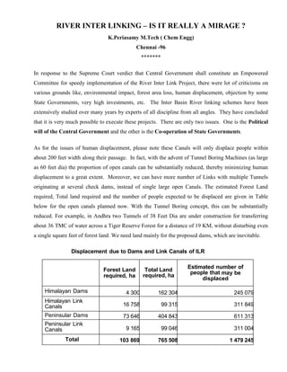
  • 9. Now let us analyse the perceived negative aspects of these projects in detail. Land Requirement The estimated Forest Land required, Total land required and the number of people expected to be displaced are given in Table -2. Please note that these Canals will be about 100 -150 m wide only as against even a KM wide ( 1000 m) in case of rivers. In fact, with the advent of large Tunnel Boring Machines (as large as 60 feet dia) the proportion of open canals can be substantially reduced, thereby minimizing human displacement to a great extent. Moreover, we can have more number of Links with multiple Tunnels originating at several small dams, instead of single large open Canals originating from large dams. Use of Tunnel Boring machines in selected locations needs to be analysed from various aspects like saving in net total submergence, human displacement, environmental impacts, cost-benefit analysis, etc. For example, in Andhra Pradesh two Tunnels of 38 Feet Dia are under construction for transferring about 36 TMC or 1.2 BCM of water across Amrabad plateau running beneath the Nagarjuna Sagar Tiger Reserve Forest for a distance of 19 KM. This is done without disturbing even a single square feet of forest land. Land requirement for the proposed dams is inevitable. It is estimated to be about 7,65,000 hectares for all the 29 Links. Compare this with that of the 3,50,00,000 hectares of land to be irrigated. The area that will be irrigated is about 46 times of the area being submerged. Please note, this 7,65,000 hectares will not always be submerged. There will be vegetation in the upper reaches of the dams whenever these dams are not full. Human Displacement When all these projects are implemented, about 1.4 million people are expected to be displaced. Human displacement is not anything new in the history of mankind. In India, annually average of about 2 Million people migrate from villages to towns, from towns to cities and from India to abroad. This migration happens in a haphazard manner and we are forced to handle a host of complex social and economic issues. Compared to this, the displacement of 1.4 million people
  • 10. due to these 29 projects is nothing. Moreover, this displacement is expected to happen in a planned manner with direct government intervention over a period of 2 to 3 decades. Further, these Projects will reduce the long distance migrations to a great extent owing to the improved economic activity that will take place in rural areas. We need to take credit for this aspect while considering the human displacement due to these projects. This also has associated environmental benefits by way of lesser transport requirements of people and resources over long distances. Table - 2 Land Required and Human Displacement due to Dams and Link Canals of Proposed Links Forest Land required, ha Total Land required, ha Estimated number of people who may be displaced Himalayan Dams 4 300 162 304 245 079 Himalayan Link Canals 16 758 99 315 311 849 Peninsular Dams 73 646 404 843 611 313 Peninsular Link Canals 9 165 99 046 311 004 Total 103 869 765 508 1 479 245 Negative Environmental Impacts The following are the important negative environmental impacts that are likely to happen when this River Inter Linking scheme is implemented. 1. Loss of flora(plants) and fauna(animal life). 2. Loss of Biodiversity 3. Loss of part of the sediments carried by rivers to delta. 4. Possible increase in salinity of irrigated land. 5. Possible water logging in certain areas. For sure, these are impacts which can be expected. But the quantum of these impacts are not anything which will adversely affect the nature in any significant manner that it will pose grave
  • 11. environmental danger as perceived and threatened by a few NGOs. Let us understand these aspects in detail. 1. Loss of flora and fauna : This happens when we build dams and the water gets filled up submerging the land upstream of the dams. Most of the animal life will survive by moving to upper reaches as the dams get filled up. Only the smaller insects and microbes which can not move up will be lost. The entire flora present in the submerged area will be lost. The loss of these smaller insects, microbes and the flora anyway is not anything that happens only due to the construction of dams. Since the dams are built mostly in the low lying areas only, these areas are anyway subjected to flooding and inundation, now and then leading to disturbances to flora and fauna. Only difference is that it will happen at some higher elevations also when the dams are built. The arguments of extinction of certain flora and fauna due to dams are not tenable. It is not that those will exist only in the particular elevation and in that particular location. Even if it is so, anyway those will be lost due to annual flooding in normal course even without the dams. As for the loss of certain flora and loss of important fauna like tigers, lions, etc, we can very well compensate by creating additional forest area and creating alternate habitats. The impact due to canals are of much lower proportions as the land area required does not fall in sensitive areas like forests or hills. Hence, we shall be aware that though there will be some impact on the flora and fauna due to these projects, it is not as bad as we are made to believe with superlative proportions.
  • 12. 2. Loss of Biodiversity : It is expected to happen for two reasons. One is due to loss of certain flora and fauna which are specific to the locations where the dams / canals are built. The second is the loss of biodiversity associated with the change in cropping pattern due to canal irrigation. As explained above, the first one, loss due to dams / canals is not much, since anyway those areas are subjected to submergence in certain periods of the year and the dams only prolong that The second one, yes it will happen. The coarse cereals like millets, jowar, etc will give way for the high productive rice / wheat crops. This is inevitable. But we must understand that change of biodiversity is a dynamic one. Did we have all the crops that we have today in India about 1000 years back ? In the same way we can not guarantee that these crops / animals will continue to live after 1000 years. But we want to ensure that the human beings survive. This is survival of the fittest. This is part and parcel of nature. But, we must note one important aspect. The advocates of these dams and canals have always been advocating population control also in India, so that the need for these dams and canals are minimized. But, we can never find any of these NGOs and “experts” who oppose the development activities advocating population control. On the other hand, they will be making loose statements like even after 60 years of Independence we do not have water, we do not have power, we do not have sufficient food, etc ! We must understand the immaturity of these people and ignore them. 3. Loss of sediments carried by rivers to delta : Yes, there will be some settling of the sediments in the dams. But, is it not a benefit ? If the rivers are allowed continue to carry millions of tons of silt from the upstream areas and dump it in the delta year after year, is it not posing a major environmental hazard ? If the silt continues to get deposited in the delta region, will it not alter the ecology of the delta ? Will it not alter the course of the rivers / canals in the delta ? In fact, it is one of the reasons for flooding of delta regions leading to damages to crops and humans. What is important to note here is that, we ta lk
  • 13. of human and crop loss only. What about loss of flora and fauna due to these floods every year ? The dams ameliorate the situation to some extent by allowing part of the silt to settle in the dam which is closer to the place where it is generated compared to the delta. Moreover, further erosion is substantially reduced due to the controlled flow taking place from the dams. The rivers are made to flow within the already established flow paths, well within their boundaries. Hence, we must look at dams as a positive factor as for as silt is concerned. 4. Possible increase in salinity of irrigated land : Over a period of time, the salts carried by the canals originating from the dams may create salinity in the irrigated land. This depends upon the origin of the rivers and the soil property enroute. One must understand that this will happen whether we use the water through canals originating from the dams or we directly use the river water in delta regions ! In fact, with dams we get partial settlement of silt thereby minimizing the salinity issue. Moreover, we have simple agricultural technologies for controlling the salinity on a n yearly basis with proper soil testing. 5. Possible water logging in certain areas : This is simply an exaggerated matter based on situations prevailing in a very narrow region in Punjab. As can be seen from Figure-4, the south western region of Punjab has water logging, ie water table is within 2 m ( 6.6 Feet). The area is about 2 lakh hectares. The total cropped area of Punjab is 18 lakh hectares. It works out to about 10%. Is it really a big issue ? Is it really a non-solvable problem ? Please note, Punjab has one of the highest canal network(14500 km) with about 98% of the cropped area under irrigation ! Can we ever dream of this situation for the rest of the country ?
  • 14. WATER LOGGING IN PUNJAB Figure - 4
  • 15. It has happened in Punjab because of the lack of awareness among the people and the indifferent attitude of the officials concerned. If we regulate the canal water and ground water pumping, this will automatically get solved and it is already being done. Citing this as a reason for not creating additional irrigation facilities in rest of the places in India is ridiculous ! Positive Environmental Impacts With regard to the environmental impact, there is a complete misunderstanding among the environmental activists. They perceive that any human activity can only lead to destruction of environment. They don’t want to look at the positive impacts of various development activities initiated by the planners. For example, if a Dam is built, they look at only the one time submergence of few thousand acres and the associated environmental impacts. But, they fail to appreciate the submergence of several thousand acres due to flooding that is taking place year after year in the absence of these dams and associated canals. PEAK FLOW REDUCTION BY DAMS Figure -4
  • 16. Figure-4 depicts how the dams minimize the peak flow in rivers thereby reducing the flooding. It has been estimated that the peak flow will be reduced by about 30% in the Himalyan rivers. This reduction in flooding brings substantial benefits in terms of environmental impacts apart from the obvious benefits in terms of reduction in human losses, year after year. It is worth highlighting here that, very often the people who oppose this project take the example of Ganga which has peak flow of about 50,000 M3/ Sec across Farakka Barrage and a diversion of 1400 M3/Sec upstream of Farakka Barrage is planned. They argue that this minor diversion(2.8%) is not going to benefit flooding in any significant manner. What they fail to understand are that 1) The peak flow reduction is not by diversion and it is mainly by storage during the peak flow periods 2) Ganga is not the only river which is flooding and there are many other flooding rivers from where the diversion percentage are higher than this example, apart from the storage. Also, it is interesting to note that, without understanding the inevitability of the release of excess water once the dams get filled up, some of these NGOs blame the dams itself for the flooding ! Further, they are so much ignorant that they are not able to understand the fact that the peak flow caused by the excess flow coming after the dam is filled is much lower and the flooding impact will also be naturally much lower compared to that without the dam. Some other “experts” associated with the NGOs calculate the total flow taking place in a particular year and say that the dams save and Link canals divert only a small percentage of the total flow and hence, their flood mitigation potential is nothing ! See the fallacy of their argument ! The flooding is due to the peak flow taking place in short periods during the monsoon time. The dams capture this peak flow and save the downstream areas from flooding. Even if we buy their argument, it only reinforces the need for creating more capacity in the reservoirs ! Further, the environmental benefits that will accrue by way of Drought prevention by these Dams and Inter Linking Canals are overlooked. Power Requirement There is a misconception that we need lot of power to pump the water from Himalayas across the Vindhyas. This is absolutely wrong. As can be seen from Table-2, power is required mainly for
  • 17. two Links: Godavari(Inchampally) - Krishna and Ganga- Subarnarekha. In all other Links, fortunately the terrain is such it flows by gravity and we have hydel power generation potential. There is potential for 30,000 MW of installed capacity. There will be net electricity generation of about 100 Bn Units after deducting the pumping requirement. Why we should worry about the pumping power requirement in few locations as long as we get a net surplus ? What is more, this hydel power is available during summer when we really need it more. There is another advantage for hydel power. It can be started and stopped in short notice. Hence it can be used for meeting the peak load demands. Hydel power is as renewable and clean as that of solar. In fact, these power projects are much better in terms of availability, storage possibility, multiple usage of the projects, etc. Need for Huge Water Storage Capacity Due to the geography and topography of India, we get non uniform rainfall over space and time. India receives an annual average rainfall of 1100 mm resulting in total precipitation of 4000 Billion Cubic Meter (BCM). About 75% of this precipitation occurs within 4 months in just about 40% of the land area. This uneven rainfall is further aggravated by the uneven spread in surface water availability due to the topography. About 60% of the total surface water is available in Ganga and Brahmaputra Basins alone. All the 400 BCM of surface water received across the International borders is also received in this region only. Only the balance is available for the rest of the Country. This leaves most part of the Central, Western and Southern Regions always under water scarcity with frequent droughts. The topography is such, at times we have flooding in some districts even while the neigbhouring districts have Drought. The loss of flora and fauna due to these droughts are as important as that lost during the flooding. Obvious ly, this calls for the storage of the rain water, the nature’s gift, whenever and wherever it is available in excess for using it whenever and wherever it is in shortage. The human civilizations have been practicing this concept for thousands of years across the globe. It is not anything new that Indians alone want to do it now. Though we have an average precipitation of about 4000 Km3 ( 4000 BCM) per year, our storage capacity is just 314 Km3, with 174 Km3 from large dams and the balance from other storages. This translates into 3300 m3 of rainfall and 262 m3 of storage on per capita basis. This storage is one of the lowest in the
  • 18. world. Compare this 263 m3 per capita Indian storage with that of China at 2486 m3, North America at 6150 m3, Brazil at 3255 m3, South Africa at 746 m3 as of 2002. The storage capacity of all our Dams put together is 174 Km3. Whereas, the storage capacity of just one Dam across Zambezi river at Kariba in Zambia / Zimbabwe border is 180 Km3 ! Aswan dam in Egypt has a capacity of 169 Km3. Three Gorges Dam in China has a capacity of 39 Km3. The Indira Sagar dam, the largest dam in India, has a capacity of just 12.2 Km3. Sardar Sarovar Dam capacity is 5.8 Km3. The capacity of Mettur dam is just 2.64 Km3. We can imagine what is the capacity of our other dams ! Due to this meager storage capacity in India, the peak flows that take place during the few weeks of monsoon time in each year, results in flooding. This leads to discharge of huge quantities of water into the sea through a few rivers like Brahmaputra, Ganga, Mahanadi, Godavari, Krishna, some small rivers of Kerala, etc. Some people come out with abstract statements like Watershed Management, Small check dams, Barrages, Rainwater harvesting, etc whenever the river inter linking projects are discussed. Obviously, they do not know that we are talking about Billions of cubic meters of water flowing in certain regions in short periods, and these regions have such topographies that small check dams are not feasible and the concepts like Watershed management, rainwater harvest, etc are totally irrelevant here. At the maximum these can supplement the dam storages in a small way and these can never be alternatives for the 29 Inter Basin transfer schemes. Hence, we desperately need to build more dams and canals to store the rain water and use it effectively. It is simple common sense that any resource that is available only during certain period of the year in certain regions only, needs to be stored and used during the rest of the year in rest of the areas. This is part and parcel of natural activity. Mother earth will not find fault with us for this, especially for a resource like water, which is crucial for the existence of life on earth. Project Cost The total cost for all the 29 Links has been estimated at Rs.5,60,000 crores at 2002-03 prices. Of course, now the cost is higher to the extent of inflation in the past 12 years. It works out to about Rs.12,00,000 crores at current (2104) prices. This Rs.5,60,000 includes about Rs.1,50,000 Crores for the associated power projects. This includes a contingency of Rs.1,05,000 crores. We must keep in mind that this estimate has been made over a period of many years for different links and these have been normalized with a year on year cost escalation factor of 10% upto 2002-03. This
  • 19. escalation factor of 10% is very much on the higher side. With the result, this total cost of Rs.5,60,000 crores is a highly pessimistic estimate and it will surely take care of unexpected cost over runs. Many consider this as a single project involving an outlay of Rs.12,00,000 crores. They also think that all the Links need to be executed simultaneously. This is one of the reasons for them to oppose this scheme on the grounds: 1.Where do we go for such a big sum ?, 2. Whether it will not cause ecological damage in a big way ? Actually, these are totally independent projects spread across a vast area. It is not about diverting all the water from one river basin to another river basin. We are only taking a part of the water going waste in one river basin for utilizing it in between the two adjacent river basins, with only the surplus water being transferred to the next basin. In most cases, the beneficiary basins fall within the same States. So, the fear of large scale ecological damages are only perception based, and are not based on any scientific studies. We can execute these projects in phases as and when we have funds. When we can get Rs.2,50,000 crores for Under Ground Metros in 22 Cities, can we not get Rs.12,00,000 crores for this National project ? When we are ready to spend Rs.1,50,000 crores for getting about 26 Billion units from 20,000 MW of Solar power, should we not spend the amount to get about 100 Billion units from the 30,000 MW of hydro power projects associated with these River Link projects ? Objections by State Governments As for the objection by some States, it is a well known fact that, the States which are having surplus water do not want to admit it and they do not want to share it, even if it goes waste to the Sea. Many people cite this as a reason for not executing the project. It is a childish argument. This happens even within the States, within districts, within villages, within homes ! Can we keep quite ? In fact, the Supreme Court has asked the Central Government to mainly deal with this aspect. For example, Andhra and Odhisa have not agreed to the data on water surpluses in Mahanadi and Godavari. It does not mean that there is no surplus water in these rivers. We see it year after year during the monsoon periods and we keep paying for flood reliefs to Odhisa and Andhra. Also,
  • 20. just because these State Governments took negative stands on these projects in earlier years, it does not mean that they will never see reason and accept the benefits that will accrue to their own States, apart from the neigbhouring States. After all, wisdom has to prevail some day or the other. Then, there are talks about Kerala’s objection to Pamba-Achankoil-Vaipar Links. Yes, it is true. Kerala opposes anything and everything new inside Kerala. But they enjoy the water and electricity being provided by the dams built by earlier governments. They do not permit coal / nuclear power plants inside Kerala. But they enjoy the electricity supplied from these power plants located in neighboring States ! How long this can go on ? Some day, the young minds of Kerala will prevail over the old, and that day, those Links in Kerala will be feasible. But the moot point here is that, should the rest of the country wait till those young minds to revolt and bulldoze those old guards ? The Supreme Court and the Engineers like us, in their wisdom prefer not to wait. It is upto the Nation to decide. Should the Central government decide to take these projects forward in an easy route, it can consider royalty payments for the water transferred, like for any other natural resource. As long as we are convinced of the overall benefits for our people, we should not worry about who gains more and who gains less. We can not also keep quiet based on past failures. If the people concerned are not convinced by all scientific data, and do not want to abide by the give and take policy, which is the corner stone of any democracy, then we shall not hesitate to enforce the law of the land. If need be, we can bring in suitable Constitutional Amendments. That is what is the crux of the Supreme Court judgment. Indian Experiences Beas- Sutlej Link, Kurnool-Cuddapah Canal, Rajasthan Canal which takes water from Sutlej & Beas rivers, Periyar Project, Parambikulam-Aliyar project, etc with supporting dams and canals are all examples of successful links. There are about 5200 large dams (with dam height above 15m) with associated canals irrigating about 108 Million hectares. Some of the dams are in existence for more than 100 years. Without these dams and canals, India could not have fed the 120 crores people today. Without additional water we can not feed the additional 20 crores
  • 21. people expected to add up in the next few decades. If we are to talk about “environmental damages” of about 500 large dams proposed in the Inter Link canals, we need to dismantle these 5200 dams as well. International experiences In Canada, about 285 BCM of water is transferred between river basins. In USA, about 45 BCM is transferred already and there are projects under way which will transfer about 376 BCM. China has a project for transferring 45 BCM through Eastern, Central and Western canals. The Indian scheme is expected to transfer about 200 BCM of water. These Inter link projects may look as stupendous tasks for old people who have no knowledge of modern developments. Look at Three Gorges Dam built by Chinese. It was planned in 1919 and was finally completed in 2008. It is an engineering marvel. Yes, it has displaced 1.3 million people. Still they did it for the betterment of the masses. It is producing 22,000 MW of power and it is providing additional irrigation for about 5,75,000 Hectares. Compare this project with that of our River Inter Link projects which are expected to displace only about 1.4 Million people, but irrigate about 3,00,00,000 Hectares ! Population the deciding factor All Indians must understand a very important aspect with respect to population which is unique to India. It is not just the second largest total population. It is more than that. India has the combination of the following three important demographic factors : 1. Very high total population of 125 crores, next to China which has about 135 crores. 2. Very high population density of 382 per Sq KM compared to just 143 of China and 34 of USA. 3. Near uniform spread across the country with just a few exceptional areas like Thar desert and Chambal valley. This demographic combination demands wide spread development keeping the people close to wherever they are unlike other counties, which try to bring all the people to few cities thereby
  • 22. providing common facilities at a cheaper price with better scale of operation. Since we have high population density, we will get the scale of operation at the Town levels itself. Hence, we must plan for our urbanization with a broader spread across several thousand towns and not within the 300 and odd cities. This demands providing water throughout India as much spread out as possible. This is an important and decisive reason for building more dams to store water and utilize it across the country for the betterment of our teaming millions. India is unique and it obviously demands unique solutions for our problems. We can not compare with any nation for any issue and devise methodologies similar to theirs. If Europeans are not building many dams, it is because they have enough food and they have declining population. Is it the case with India ? We can not satisfy the transport needs with personal vehicles like two wheelers and cars which many other countries do, which unfortunately India is also copying. We need Buses and Trains in plenty. We do not want few bullet trains at exorbitant cost, but we need all trains to run at atleast 160 KMPH. We can not rely on Solar power which is available only during day time when we do not need it much. Whereas, solar power suits Germans because they need more electricity exactly when sun shines more. Hence, let us abhor ideas of experts and preachers from other countries who have knowledge and data completely different from our ground realities. Their ideas and solutions in most cases will be irrelevant for our needs. Let us take only capital from them and not ideas and policies. Conclusion The River Inter Link Projects are technically feasible, economically viable and environmentally benign. There are only two impediments. One is the Political will of the Central Government and the other is the Co-operation of State Governments. Rive Inter Linking Projects could be misleading as a mirage for those who do not want to travel that extra mile to see that it is in deed real water, and not a mirage. Old people might have experienced that mirage in the past since this project is being talked about for so many years with nothing tangible coming of. They do not realize the fact (or they do not have the stamina of mind
  • 23. to travel that extra mile) that, with the new faces coming to the helm of affairs, we can see to that it is really water, and not mirage ! The media must realize this and spread a positive message on important national projects like this. They shall not sing the same old negative songs and mislead the nation. &&&&&