The document describes the original concepts of the neighborhood unit plan proposed by Clarence Perry and the Radburn neighborhood model developed by Clarence Stein and Henry Wright in the early 20th century. Both aimed to design self-contained residential neighborhoods with schools, parks, and other amenities within walking distance. Perry's neighborhood unit emphasized boundaries, a central community center, and an internal street network to discourage through traffic. Stein and Wright's Radburn model organized neighborhoods into hierarchical levels from enclaves to superblocks and included separating vehicles from pedestrians. While similar in goals, the two approaches differed in details like maximum walking distances and treatment of neighborhood boundaries. The concepts shaped mid-century urban planning and remain influential today.
3. The Neighbourhood unit plan in in brief is the effort to create a residential
neighbourhood to meet the needs of family life in a unit related to the
larger whole but possessing a distinct entity characterised by six factors :
1. A child need not cross traffic streets on the way to school.
2. A centrally located elementary school which will be within easy
walking distance, no more than one and a half mile from the farthest
dwelling.
3. A housewife can walk to a shopping centre to obtain daily household
gifts.
4. Convenient transportation to and from the workplace.
5. Scattered neighbourhood parks and playgrounds to comprise about
10% of the whole area.
6. A residential environment with harmonious architecture, careful
planting, centrally located community buildings, and special internal
street system with deflection of all through traffic preferably on
thoroughfares which bound and clearly set off neighbourhood.
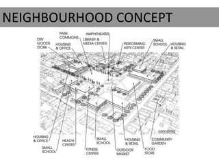
What is Neighbourhood Unit Plan?
4. • The neighbourhood concept is arguably one of the major planning
landmarks that shaped the urban form of the twentieth century city in
many countries.
• Coincidently, both the neighbourhood idea of Clarence Stein and
Henry Wright, exemplified in their plan for Radburn, and the
Neighbourhood Unit idea of Clarence Perry were published in 1929.
• The urban design principles of Stein and Wright included the idea of a
superblock of residential units grouped around a central green, the
separation of vehicles and pedestrians, and a road hierarchy with cul-
de-sac for local access roads. A cluster of superblocks was to form a
self-contained neighbourhood. A group of neighbourhoods would
then comprise the city.
• For Perry the physical arrangement of the elementary school, small
parks and playgrounds, and local shops was the basis of his
neighbourhood idea. Each neighbourhood was to be a unit of the city.
6. The design of the Radburn neighbourhood model was in essence a
hierarchical one comprising four levels –
• Enclave
• Block
• Superblock
• Neighbourhood.
RADBURN MODEL
by Clarence Stein and Henry Wright
7. ENCLAVE
• The fundamental component
was an enclave of twenty or so
houses.
• These houses were arrayed in a
U-formation about a short
vehicular street called a
lane,really a cul de-sac court
with access to individual
garages.
• While the back of each house
faced this court the front of the
house had a garden.
Cul-De-Sac meaning Dead End
8. BLOCK
• Three or more of these enclaves were lined together to form a block.
Enclaves within the block were separated from one another by a
pedestrian pathway that ran between the front gardens of all the
houses.
• The blocks, usually four in number, were arranged around the sides of a
central parkway in such a manner so as to enclose the open green space
SUPERBLOCK
• The clustered 5 blocks together with the central parkway comprised what Stein
and Wright termed a superblock.
9. Neighbourhood
• Four to six superblocks commonly formed a neighbourhood that
was bounded by major roads or natural features.
• At one end of the parkway there could be a small school with
community rooms. Roads in the neighbourhood were to be
hierarchical - major through traffic roads to border each
neighbourhood, distributor roads to surround each superblock,
and culs-de-sac to provide access to individual property lots.
• Stein emphasized that the prime goal was to design a town for
the automobile age. In fact the title on the drawing of the town
plan was A town for the motor age (Stein, 1928).
10.
11. OVERLAPPING NEIGHBOURHOODS
• Although Stein and Wright
considered neighbourhoods as
each being relatively self-
contained they arranged them in
an overlapping manner to support
joint use of facilities such as
hospitals, high schools, and
theatres.
• They visualized the
neighbourhood as forming the
building block of the city whereas
previously the lot and the city
were the basis for town design.
12. Conclusion
• To their minds there should be a three level
hierarchy consisting of neighbourhood, town, and
region.
• They believed, that future urban development
should be based on the regional city, a constellation
of smaller-sized towns tied together by a parkway
or open highway.
13. NEIGHBOURHOOD UNIT OF CLARENCE PERRY
• Chicago-trained sociologist Clarence Arthur Perry (1872–1944) became
one of the principal theorists of and advocates for the traditional
neighbourhood as a basis for the planning of new towns and urban
areas and for the redevelopment of blighted slums.
• His advocacy of the “neighbourhood unit” as a principle element of
planning was based not only on his academic interests, but also on his
direct experience as sociologist-in-residence for the Russell Sage
Foundation’s model garden suburb of Forest Hill Gardens in New York,
designed by Frederick Law Olmsted, and Grosvenor Atterbury .
14. • Perry identified six neighbourhood unit design principles.
• First, the unit was to be ideally a shape in which all sides were
fairly equidistant from the centre, and its size was to be fixed.
• Secondly, a central neighbourhood or community centre was to
contain various institutional sites, including a school, grouped
round a central green space.
• Thirdly, local shops or shops and apartments were to be located
at the outer corners of the neighbourhood.
• Fourthly, scattered small parks and open spaces, located in each
quadrant of the neighbourhood, were to form 10 per cent of the
total area.
• Fifthly, arterial streets were to bound each side of the
neighbourhood while ,
• sixthly, the layout of the internal street was to be a combination
of curvilinear and diagonal roads to discourage through traffic.
Vehicular and pedestrian traffic was to be segregated.
15.
16. • Perry’s concept of the neighbourhood was as a relatively self-
contained building block of the city, hence the addition of the
word unit to his concept.
• He identified four urban locations where the idea could be
applied new sites in the suburbs, vacant sites in the central area,
predominantly apartment districts, and central areas that had
suffered deterioration and required rebuilding .
• He later recognized that land assemblage in the existing built-up
areas of cities to create neighbourhoods was impractical and
suggested a modified process of eminent domain (government
right to take private land for public benefit with just
compensation through the process of condemnation) be applied
in the assemblage of neighbourhood unit sites.
17. Comparison of design principles
• Stein and Wright, along with Perry, agreed that the neighbourhood was to
have a limited or fixed size determined by the population needed to
support an elementary school.
• Other similarities between their two models were defining the
neighbourhood by 6 means of boundaries, the inclusion of a significant
amount of open space, a neighbourhood centre that would include the
school, and a road system that was safe for pedestrians and did not allow
through traffic.
• A critical distinction between the Radburn model of Stein and Wright and
Perry’s idea was the kind of neighbourhood boundary each envisaged.
Although Perry as well as Stein and Wright used arterial streets to form
the neighbourhood boundary, Stein and Wright preferred the use of
natural forms where possible.
18. • Another difference between the two models was the maximum
walking distances each proposed - 0.8 km in the Radburn
neighbourhood and 0.4 km in the Neighbourhood Unit model.
• Further distinctions were the superblock with its central green, the
separation of streets and pedestrian paths, and the road hierarchy of
the Radburn model.
• Another difference was that Perry envisaged the neighbourhood as a
separate urbanUnit. When a number of units were amalgamated they
would form the city. Stein and Wright, on the other hand, conceived
the Radburn neighbourhoods as overlapping one another and
grouped into districts to support large-scale facilities.
19. Neighborhood-unit principles
• Size. A residential unit development should provide housing
for that population for which one elementary school is
ordinarily required, its actual area depending upon
population density.
• Boundaries. The unit should be bounded on all sides by
arterial streets, sufficiently wide to facilitate its bypassing by
all through traffic.
• Open spaces. A system of small parks and recreations
spaces should be provided, planned to meet the needs of
the particular neighbourhood.
• Institution sites. Sites for the school and other institutions
having service spheres coinciding with the limits of the unit
should be suitably grouped about a central point, or
common area.
20. Internal street system. The unit should be provided with a
special street system, each highway being proportioned to its
probable traffic load, and the street net as a whole being
designed to facilitate circulation within the unit and to
discourage its use by through traffic. To offer a clear picture of
each of these principles, the figures illustrate plans and
diagrams in which the principles have been applied.
Local shops. One or more shopping districts, adequate for the
population to be served, should be laid out in the
circumference of the unit, preferably at traffic junctions and
adjacent to similar districts of adjoining neighbourhoods.
22. Character of district. The plan shown in previous slide is based upon an actual tract
of land in the outskirts of the Borough of Queens.
Population and housing. The lot subdivision provides 822 Single family houses, 236
double houses, 36 row houses and 147 apartment suites, accommodations for a
total of 1,241 families. At the rate of 4.93 persons per family, this would mean a
population of 6,125 and a school enrollment of 1,021 pupils. For the whole tract
the average density would be 7.75 families per gross acre.
23. • Open spaces. The parks, playgrounds, small greens and circles in the
tract total 17 acres, or 10.6 percent of the total area.
• Community center. The pivotal feature of the layout is the common,
with the group of buildings that face upon it. These consist of the
schoolhouse and two lateral structures facing a small central plaza. One
of these buildings might be devoted to a public library and the other to
any suitable neighbourhood purpose. Sites are provided for two
churches, one adjoining the school playground and the other at a
prominent street intersection.
• Shopping district. Small shopping districts are located at each of the
four corners of the development. The streets furnishing access to the
stores are widened to provide for parking, and at the two more
important points there are small market squares, which afford
additional parking space and more opportunity for unloading space in
the rear of the stores. The total area devoted to business blocks and
market plazas amounts to 7.7 acres.
• Street system. In carrying out the unit principle, the boundary streets
have been made sufficiently wide to serve as main traffic arteries. One
of the bounding streets is 160 feet wide, and the other three have
widths of 120 feet. Each of these arterial highways is provided with a
central roadway for through traffic and two service roadways for local
traffic separated by planting strips.
24. NEIGHBORHOOD
UNIT FOR AN INDUSTRIAL
SECTOR
Plan on the right is a sketch of the kind of
layout, which might be devised for a
district in the vicinity of factories and
railways.
25. Functional dispositions. The above features dictated the employment of a
tree-like design for the street system. Its trunk rests upon the elevated
station, passes through the main business district, and terminates at the
community center.
Housing density. is intended to suggest mainly an arrangement of the
various elements of a neighbourhood and is not offered as a finished plan.
The street layout is based upon a housing scheme providing for 2,000
families, of which 68 percent are allotted to houses, some semi-detached
and some in rows; and 32 percent to apartments averaging 800 square
feet of ground area per suite. On the basis of 4.5 persons in houses and
4.2 in suites, the total population would be around 8,800 people.
Recreation spaces. These consist of a large schoolyard and two
playgrounds suitable for the younger children, grounds accommodating
nine tennis courts, and a playfield adapted either for baseball or soccer
football.
Community center. The educational, religious and civic life of the
community is provided for by a group of structures, centrally located and
disposed so as to furnish an attractive vista for the trunk street and a
pivotal point for the whole layout.
26. Shopping districts. The most important business area is, of course,around
the main portal and along the southern arterial highway. For greater
convenience and increased exposures a small market square has been
introduced.
29. Population. On the basis of five-story and basement buildings and
allowing 1,320 square feet per suite, this plan would accommodate 2,381
families. Counting 4.2 persons per family, the total population would
number 10,000 individuals.
Environment. The general locality is that section where downtown
business establishments and residences begin to merge. One side of the
unit faces on the principal street of the city and this would be devoted to
general business concerns. A theater and a business block,penetrated by
an arcade, would serve both the residents of the unit and the general
public.
Street system. Wide streets bound the unit, while its interior systemis
broken up into shorter highways that give easy circulation within the unit
but do not run uninterruptedly through it.
Open spaces. The land devoted to parks and playgrounds averages over
one acre per 1,000 persons. If the space in apartment yards is also
counted, this average amounts to 3.17 acres per 1,000 persons.
Community center. Around a small common are grouped a school,two
churches, and a public building. The last might be a branch public library, a
museum, a “little theater,” or a fraternal building. In any case it should be
devoted to a local community use.
31. Locality. The plan shown in previous slide is put forward as a suggestion of
the type of treatment which might be given to central residential areas of
high land values destined for rebuilding because of deterioration or the
sweep of a real estate movement. The blocks chosen for the ground site are
200 feet wide and 670 feet long, a length that is found in several sections in
Manhattan.
Ground Plan. The dimensions of the plot between the boundary streets are
650 feet by 1,200 feet, and the total area is approximately 16
acres.
32. Accommodations. The capacity of the buildings is about 1,000 families,
with suites ranging from three to fourteen rooms in size, the majority of
then suitable for family occupancy. In addition there would be room for a
hotel for transients, an elementary school, an auditorium, a gymnasium, a
swimming pool, handball courts, locker rooms and other athletic facilities.
The first floors of certain buildings on one or more sides of the unit could
be devoted to shops.
Height. The buildings range in height from two and three stories on the
boundary streets to ten stories in the abutting ribs, fifteen stories in the
main central ribs, and thirty-three stories in the two towers.
33. SOURCES
• URBAN PLANNING THEORY AND PRACTICE,M PRATAP RAO, Page no.
114-116.
• TIME SAVERS STANDARDS URBAN DESIGN, CLARENCE ARTHUR
PERRY,PAGE NO. 2.4.1-2.4.7
• PLANNING AND URBAN DESIGN STANDARDS
• URBAN DESIGN PRINCIPLES OF THE ORIGINAL NEIGHBORHOOD
PRINCIPLES, PAPER BY NICOLAS PATRICIOS,UNIVERSTIY OF MIAMI
• http://en.wikipedia.org/wiki/Neighbourhood_unit