2. Contents
Introduction
Aims & Objectives
Projects
Seabirds
Species List
Population monitoring (Tern, Fulmer & Kittiwake)
Ornithology survey of reserve
Vegetation
Lupin
Invertebrate
Bumblee bee Foraging
Preliminary pitfall project
Logistics
Funding
Expenditure
Itinerary
Acknowledgments
Appendix
3. Introduction
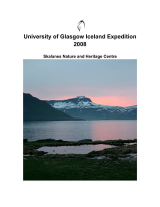
Skalanes nature and heritage centre is a private reserve managed as a conservation site for
environmental education and sustainable tourism. At 1250ha, the reserve hosts boasts a
number of environmentally important flora and fauna including one of Icelands largest colonies
of Arctic Tern (Sterna paradisaea), 600m sea cliffs hosting significant numbers of nesting sea
birds (including Puffin, Kittiwake and Fulmar) and is home to the elusive arctic fox. Results from
the research carried out within Skalanes reserve are to be used as the foundation for
developing a sustainable management plan of the area and also as educational material for
visitors and interested parties.
Glasgow University Iceland Expedition 2008 has been the first University group to work at
Skalanes since it has been established as a nature reserve in 2006. The purpose was to
develop a series of monitoring schemes and studies of the resident flora and fauna to build on
the knowledge of the area where such knowledge will be an essential tool in supporting
sustainable tourism and education on the reserve.
This document provides a detailed description of the work carried out by the expedition
members, our methodology and a summery of how this will be integrated into the working
reserve and the future.
Vicki Tough
Expedition Leader
4. Aims and Objectives
The aim of the expedition was to raise awareness of the ecological significance of the reserve
by conducting a series of scientific studies directly relevant to the conservation and future
management of the site. As the first University Expedition to Skalanes all work carried out was
incorporated into a broad preliminary study of the area and its long term research potential.
Ornithology: To create a comprehensive list of all resident bird species, their
abundance and locality within the reserve.
Seabird Monitoring: To establish routine survey techniques for avian populations within
the reserve with the intention that these will continue annually in
order to monitor populations for optimum species management
Vegetation: An investigation into the ecology of the introduced species of
Arctic Lupin (Lupinus Nootkatensis) within the site and its impact
on the native flora and fauna.
Terrestrial Invertebrate: To study the foraging dynamics of bee species against wildflower
distribution within the reserve and collectively gain an insight into
the pollination ecology of Skalanes.
5. Projects
Ornithology
A study into the abundance, locality and ecology of resident bird life at Skalanes
Nature Reserve
David Holt, William Purnell and James Robinson
Introduction
With striking sea cliffs, rocky shores and vast heath land the reserve hosts a multitude of prime
breeding grounds creating an area abundant in bird life. 0ver 30 resident species have been
recorded in the past few years including Black tailed godwit (Limosa limosa), Harlequin Duck
(Histrioniculus) and Ptarmigan (Lagopus muta).
Without a specific bird guide to the area the diversity of bird life has been left unrecorded. As
the reserve caters to a range of visitors with different degrees of ornithology experience the
decision was made to produce a localised bird guide for the use of all guests to Skalanes and in
combination gather a comprehensive species list of bird life to the area observed.
Methodology
The reserve was split into five main sections from west to east and then spending a day
observing the birds in each section. Each main section was split into three smaller more
manageable areas where observations were made over a six to eight hour period between the
hours of 10.00 and 16.00 (this was estimated as the time period the majority of the guests would
be visiting.) The species identified were recorded and were marked as G (seen on the ground)
or F (flying) and photographs were taken for use as illustrations in the bird guides.
6. Species seen on the ground more than three times in one area were considered to be of
significance in that area. The species found to be most common to a particular area i.e. seen
more than three times on the ground in any one area, were allocated to one of the three main
areas of habitat and thus to one of the walks.
1. West Shore: Moderately sheltered shore west of the visitor centre containing a mixture
of rocky and sandy shores as well as some small rocky outcrops.
2. East Shore: Exposed shore east of the visitor centre of rocky outcrops and tall, sheer
sea cliffs.
3. Heathland: Area of raised moor like scrub land south of the visitor centre lying between
the shore line and steep scree slopes.
With distinct species found to inhabit each area the three different habitats were used as a
means to split up the reserve into individually marked walking routes with a guide to bird life for
each route.
The main species of bird that had been identified over the five day watching period as being the
most commonly seen were then divided between the three walk guides based on where they
were most common. Some of the species were included in multiple guides as they were
common in many areas.
A preliminary route was planned for each habitat, marked by colour and a basic map was
produced to allow visitors to navigate their way along these routes. ( Appendix 1a, b & c).
7. Results
29 different species of bird were recorded within the 5 day observation period. Photo
identification of each species plus a simplified descriptor for each was used to make the guides
not only accessible but informative to a broad range of experience with information about both
the terrain and estimated duration of each walk.
The walking guides were produced and independent parties were asked to trial them to provide
feedback.
Conclusion
As use of the guided walks increases, visitor observations and comment will be used as an
indicator of species observed and their frequency to the area. However, the current guides are
still unfinished, some species proved difficult to photograph with the limited camera equipment
possessed by the team and the species list will be an ongoing accumulation of observations and
recordings of bird species each year to achieve a sound knowledge of the bird life within the
reserve.
8. Map of Skalanes reserve showing the routes of the three guided trails and all significant landmarks of the
area Skalanes Visitor Centre, sea cliff view points and Skalanes reserve boundary river.
A preliminary study into monitoring the seabird populations of Skalanes Nature
Reserve
Chiara Guidi and Julie Miller
As a focal point of Skalanes reserve it is our aim to quantify as much knowledge as possible
about the seabirds to understand their significance to the area as a whole. The monitoring plan
is set to provide information on changes in populations from year to year with additional
observations made about the process of events determining these changes by monitoring
variable factors affecting breeding success i.e. foraging effort.
9. As an important indicator species for marine life, a well established seabird monitoring plan will
provide results that can be ultimately fed into other seabird projects and contribute to larger
scale flora and fauna research schemes.
Methodology
All methodology are based on the techniques described in the seabird monitoring
handbook for Britain and Ireland. JNCC/RSPB/ITE/Seabird Group (Walsh et al 1995.)
Arctic Tern
Described as one of the largest colonies within Iceland (Aevar Peterson), the tern population
until this summer was a single large colony nesting either side of the road by Skalanes house.
Two separate colonies now inhabit the area where by a sub colony* is nesting on the banks by
the newly built ponds next to the house. Whether the colony has branched off due to
disturbance by building and construction work around the house early this spring or that the
area is preferential is unknown, however colony counts took place separately within the two
nesting locations.
With a steadily increasing number of nesting eider ducks around the house more disturbance
from an increasing number of visitors to the centre an annual colony count of the terns will be
beneficial to monitor fluctuations in populations size and breeding success.
10. Methodology
Nest Count
7 people standing equal distances apart along the length of the breeding ground walking
a steady pace through the colony.
All nests and chicks within a 2 metre radius either side of each person are counted and
totalled at the end of the walk.
Adult Population Count
7 people standing equal distances apart walk the length of the colony flushing all adults
into the air.
One person standing at high vantage point (top balcony) takes several photographs of
birds in the air to be marked and counted digitally on the computer at a later date.
Count of adult tern population within two separate colonies
Cliff-Side Colony Road-Side Colony
Photo no. of flush count
1 301 326
2 352 501
3 360 438
4 357 436
5 344 575
6 370 454
7 214 546
8 284 460
9 293 591
10 334 -
Estimated number of 321 481
adult terns within the
colony∗
*The total number of adult terns nesting within a colony was calculated from averaging the total
number of terns recorded in each of the 10 representative photos. Numbers were rounded up to
the next whole number.
11. Colony Nest Chick
count count Count
Roadside 481 212 15
Colony
Cliffside 321 229 7
Colony
Summery of tern, nest and chick counts for both colonies. Both nest and chick counts were
carried out once in mid June.
The recorded number of individual birds for the roadside colony was calculated as 481 birds
with 212 nests and 15 chicks. 321 individual birds were recorded for the cliff side colony with a
greater number of nests, 229, and 7 chicks. During this count a number of chicks were noted in
each colony and estimated to be under a week old on the 15th of June, thus indicating that an
estimated fledging time of early to mid July, however due to a 10cm rainfall in 24 hours on the
1st of July the majority of the chicks perished during this time and only 3 were seen to be training
with their parents subsequent to the colonies migrating.
By assuming the number of individuals recorded in each colony are breeding adults it is
estimated that there are approximetly 400 breeding pairs within the two colonies.
kittiwake
Cliff face split into 7 distinct sections marked by natural contours in the rock.
Two people count all Apparently Occupied Nests ( AONs - intact nest with at least one adult
apparently nesting on the site) in each section using 12 x 8 binoculars.
The two totals for each section are then recorded where a recount is made only when there is a
difference of more than 20 birds between the two numbers.
Each section is counted, an average for each section is calculated and then a total count for the
cliff site is calculated from the averages.
12. Cliff Section
Average Section Section Section Section Section Section Section Total
AON 1 2 3 4 5 6 7 Average
Count Count for
cliff site
15/06/2008 51.5 94.5 87.5 53.5 44 40 73 444
18/06/2008 28.5 91 144 131 74 48 74 590.5
20/06/2008 27.5 80 107.5 108.5 50.5 29.5 68 471.5
26/06/2008 49.5 87.5 125.5 104.5 58.5 40.5 63 529
29/06/2008 47 91 129 104 45.5 44.5 75 536
514
Total 40.8 88.8 118.7 100.3 54.5 40.5 70.6 74
average
for
section
Table. This table shows the number of Apparently Occupied Nests (AONs) of Kittiwake
within seven different sections of a cliff site.
Results
514 Apparently Occupied Nests (AON) for kittiwakes were recorded on the cliff site with an
average of 74 AONs per section. The total number of AONs was calculated as an average of
the 5 separate counts inclusive of each of the seven sections.
Fulmars
Cliff split into the same 7 sections used for the kittiwakes and 2 people counting Apparently
Occupied Sites AOS (site big enough for an egg where slope is not too steep and there is at
least one adult fulmar present).
13. The two totals for each section are then recorded, a recount is made only where there is a
difference of more than 20 birds between the two numbers. An average is calculated from
these two totals and then used to calculate a total average for each section and the entire cliff.
Cliff Section
Average Section Section Section Section Section Section Section Total
AOS 1 2 3 4 5 6 7 Cliff
Count Count
1st count 19 33 50.5 126 14.5 33 16 292
15/06/08
nd
2 count 23.5 41.5 52 110.5 7 27.5 20.5 282.5
18/06/2008
rd
3 count 27.5 39 46 113.5 13 29.5 20 288.5
20/06/2008
th
4 count 20 36.5 38 99 4.5 20.5 9 227.5
26/06/2008
th
5 count 21 39.5 46.5 101.5 10.5 18 21 Average 258
29/06/2008 No. per
section
270
Total
average 22.2 37.9 46.6 110.1 9.9 25.7 17.3 39
for
section
Table. This table shows the number of Apparently Occupied Nests (AONs) of Fulmar within seven
different sections of a cliff site.
A total of 270 Apparently Occupied Sites (AOS) were recorded on the cliff site with an average
of 39 AOSs per section. The total number of AOS’s was calculated as an average of the five
separate counts inclusive of each of the seven sections.
14. Conclusion
The results provide a baseline of information that future monitoring can be compared against.
The site chosen was selected as a typical number of birds distributed over a marked area
however the site is representative of only a small proportion of the entire sea cliff colony of
fulmars and kittiwakes and will require more extensive monitoring over a larger area to estimate
the extent of the colonies.
Independent study into Kittiwake fatalities
On arriving to Skalanes large numbers of adult kittiwake carcasses were found littering the
rocks and coastline around the cliffs. As there were no other bird species were found to have
such high fatalities in such a small area, an unplanned study into the Kittiwake population took
place.
With limited resources and no prior knowledge of the population’s numbers or breeding
success, a project was set up to monitor the number of carcasses found on the reserve in an
attempt to find a pattern associated with the number of deaths. Possible explanations for cause
of death were;
Casualties from Mink, Arctic fox and Great Skua which are active in the area.
•
Poisoning
•
Starvation
•
Toxic Algal Blooms
•
15. Method
Kittiwake deaths were monitored by marking the presence of each carcass using GPS and
checking the cliffs and rocky shore every day to monitor whether new birds were being found or
whether birds were being removed either by scavengers or by the action of the sea washing the
carcasses off the cliffs. An observation patrol was carried out on 8 separate days within this
period and each new carcass found was recorded.
The physical appearance of the birds was noted as decomposing, predated or fresh along with
the coordinates the carcass was found, a reference number and photograph. A sample of the
carcasses were taken back for further analysis, where by each specimen was dissected and
compared for any signs of internal ill health.
In addition an observational study was undertaken using a small colony to investigate the
movements and behaviour of breeding pairs. Colony counts were taken every 20 minutes and
general behaviour recorded over a period of 2 hours.
Results
Condition of Number of
kittiwake carcass carcasses
Fresh 33
Predated 6
Decomposing 12
51 kittiwake, one puffin and one herring gull carcass were found and recorded within a 17 day
observation period. This number could be am underestimate due to high tide waters during bad
weather washing away carcasses before they were recorded. 32 birds were recorded as fresh
(no external damage or decomposition), 17 had begun decomposing and 6 had significant signs
16. of predation (tissue damage restricted to head and breast areas of the bird). On each occasion
that a bird appeared to have been heavily predated there also appeared to have degrees of
decomposition, an indicator that the predation occurred after death.
Bird counts showed the colony held an average of 50 nesting birds and 60 other birds present at
any one time, these included Fulmar, Puffin, Arctic Skua and Eider duck .
Behavioural observations identified a possible feeding ground on the opposite headland of the
neighbouring fjord however, without access to this area it was not possible to observe the birds
feeding and thus deduce if there was a lack of food to cause starvation.
Dissections showed low breast tissue and little or no stomach contents in each specimen which
could suggest starvation as the cause of death. However total body weights of each specimen
could not be carried out and therefore starvation is left to speculation. Internal bleeding was
found in only one of the carcasses as a symptom to suggest Toxic Algal Bloom as cause of
death.
Other observations included enlarged livers, and intestinal cysts were found in several of the
specimens .
Conclusion
As there was little or no information on the kittiwake population prior to this years monitoring it is
difficult to stipulate why there were such a high number of fatalities in what appeared to be
young, healthy birds. However, such observations have been logged and further studies will be
carried out in future visits to the reserve to investigate a pattern in fatality rate. Such studies will
17. include monitoring feeding success at feeding grounds, continuing with colony counts, and
recording hatching and fledging success.
A short study into the presence and foraging behaviour of bumblebees (Bombus
spp.) on Skálanes Nature Reserve.
Jessica Rose Hanley-Nicholls
Introduction
A survey of the bumblebee species present on the Skálanes nature reserve in eastern Iceland,
situated approximately 17km east of Seyðisfjörður, to ascertain whether the reserve contained
the native Bombus terrestris, and also to discover if the two invasive bumblebee species
(Bombus jonellus. and Bombus lucorum ) were present in this area of Iceland.
Surveys of the foraging patterns of the bees present were also undertaken to discover what
plants the bees were using for forage, and also to determine the affect of the invasive arctic
lupin (Lupinus nootkatensis) on bumblebee populations at the reserve. At the time of survey
plans were being formulated as to how to control and eradicate this plant, which was introduced
to halt soil erosion across Iceland but now is an ecological pest as it prevents the growth of the
native flora. The aim of the survey was to determine if the bumblebees depended on the lupin
18. for either forage or nesting, so recommendations could be put forward as to any precautions
lupin control methods should make to allow for minimum impact to these important pollinators.
This work was carried out between the 4th and 25th of June, 2008, as part of the Glasgow
University Expedition, and courtesy of Mr. Ólafur Örn Pétursson, at Skálanes Nature and
Heritage Centre.
Methods
It was decided to ensure that the plots surveyed represented the widest range of ecological
habitats possibly used bumblebees on the reserve. Fifteen plots were selected to give an
overview of abundance at different altitudes and on different plant communities. For a
description of the plots, see Table 1 in the appendix.
Five plots were surveyed at low (up to 38m), medium (39m to 63m) and high altitude (64m to
137m) sites. These heights were chosen due to very defined ledges from the cliffs up towards
the mountains. Surveys were not carried out higher than 137m due to the practicality of carrying
equipment up extremely steep slopes and also due to safety concerns, as rock falls and
avalanches are not uncommon at this time of year.
The plant communities were visually divided into five groups; tussocky grass, low heath, boggy
heath, willow scrub and lupin. An attempt was made to survey at each community at each
altitude as far as was possible (for example no surveys of lupin plots was carried out in the high
altitude category as this was above the ‘lupin line’).
19. Each plot was measured out to be 25m long and 4m wide using a GPS receiver (margins of
error for this reading varied according to the strength of signal for the GPS) and was marked out
using white painted fence posts (one at each end in the middle). Plots were then surveyed once
for vegetation, and three times for bumblebees. Surveys were endeavoured to be carried out in
a random order, however due to time constraints certain groups were always surveyed together
(but in a random order within that group). A brief assessment of environmental conditions was
carried out to ascertain if weather had an impact on the foraging behaviour of the bumblebees.
Vegetation survey.
At each plot a vegetation survey was carried out to estimate the percentage cover of the plot for
each plant species present. Flowering species were identified to species level, others such as
the grasses were classed as one group.
At each site a transect was walked along the middle line of the plot. At the starting end a GPS
reading of longitude and latitude was taken for the site and noted as the site location.
Using a 1 metre square quadrat (wooden frame with wire dividing the quadrat into 25 equal
squares) counts of the vegetation were carried out every 5 metres along the transect, with the
first quadrat being taken at 0 metres. Distance between quadrats was measured by pacing out
at 1 metre strides.
Vegetation was counted by using the quadrat to give an accurate estimation of the total area
covered by each species present by eye, both for each individual quadrat and for the plot as a
whole. For flowering species, the number of flower heads present was counted in the quadrats
20. but not in the plot as a whole.
Again, estimation by eye is subject to variation due to human error but all estimations were
made by the same person for all sites and so this variation should be constant throughout and
therefore should not have an impact on any findings.
Environmental Conditions
Wind speed was estimated using visual observations in relation to the Beaufort scale (see Table
1 in Appendix I for scale used).
Cloud cover was estimated by eye at either 0%, 25%, 50%, 75% or 100%.
Rainfall was estimated by eye as being either light, moderate or heavy.
Temperature was estimated as cold, mild or warm as a suitable electronic thermometer was not
available.
Environmental conditions were recorded for each separate bee walk. Although the
measurements for wind speed, cloud cover and rainfall are subject to variation due to human
error, as the estimations were made by the same person every time, the variation should be
constant for all sites and therefore not impact on any findings.
Charman (2006) notes that he only surveyed foraging in bees between 9:30 – 18:00 when the
temperature was above 12˚C and the wind was Beaufort 4 or weaker. The intention was to
survey under the same restraints but during the course of the study it was found to be
necessary to broaden these criteria, due to the prevailing weather conditions.
21. 2.5 Bee Walks
The method used for surveying bee numbers have been adapted from those the Pollard
butterfly monitoring technique, and is a standardised method for bee surveys used by the
RSPB.
Timed bee walks were carried out at each site with three repeats. The end of the transect from
which the bee walk started alternated for each repeat. The survey involved walking slowly along
the transect in the middle of the plot, counting any bee seen within two meters either side of the
transect, viewed from a 20 degree angle to the right and left of the surveyor (see Figure 1.). The
speed at which the transect was walked varied depending on the density of vegetation and
therefore the time needed to accurately survey the area. Bees were recorded as non-foraging if
there were flying through the surveyed area. Actively foraging bees were recorded by the
species of flower they were foraging on. Any bees which began foraging in an area after
surveying had begun were not counted to reduce the probability of the same individual being
counted twice. Bees were recorded by species, castes were not recorded separately.
Results
Regression analysis was carried out on the results using Minitab 4.0. Both environmental
conditions and site were found to have no affect on the number of bees present (see Figure 2.),
meaning that the day and order of survey should have no impact on further conclusions drawn.
RESPONSE FACTOR EXPLANATORY R-SQ (ADJ) P VALUE
FACTOR
# Foraging bees Temperature 11.2% 0.014
22. Rain 0.5% 0.275
Wind 4.8% 0.079
Cloud 0.0% 0.438
# Non-foraging bees Temperature 9.1% 0.025
Rain 0.8% 0.252
Wind 0.5% 0.279
Cloud 4.9% 0.077
# Foraging bees Site 0.9% 0.244
# Non-foraging bees Site 0.0% 0.397
Figure 2. Adjusted R-square and P values for Regression Analysis of Foraging/Non foraging vs.
environmental conditions/site.
Regression analysis was carried out on the compiled data from the vegetation and bee surveys.
Only the native Bombus terrestris was observed, although two other invasive species of
bumblebee (Bombus. jonellus and Bombus lucorum.) are known to have populations in Iceland.
Figure 3 below shows the flowering species found in the surveys, and the number of individual
bees found foraging on that species. B. terrestris was only found foraging on five plant species;
Vaccinium myrtillus, Vaccinium uliginosum, Bartsia alpine, Salix spp. and Lupinus nootkatensis.
Crowberry Empetrum nigrum 0
Heather Calluna vulgaris 0
Bilberry Vaccium myrtillus 8
Northern bilberry Vaccium uliginosum 5
Creeping aster 0
Dandelion Taraxacum spp. 0
Alpine bartsia Bartsia alpina 1
Shrub willow Salix spp. 1
Arctic lupin Lupinus nootkatensis 3
Ladies bedstraw Galium verum 0
Moss campion Silene acaulis 0
Mountain avens Dryas octopetela 0
Saxifrage Saxifraga nivalis 0
Buttercup Ranunculus spp. 0
NON FORAGING BEES 15
Figure 3. Number of foraging bees by flowering species.
Of these five species, only variation in the cover of Vaccinium myrtillus explained some of the
variation (R-sqr (adj) 37.4%, P=0.009) in numbers of foraging bees (R-sq (adj) 37.4%). The
23. presence of arctic lupin (Lupinus nootkatensis) on a plot had no affect on the numbers of
foraging or non-foraging bees (R-sq (adj) 0.9%, P= 0.244 and R-sq(adj) 0.0%, P=0.077
respectively). Arctic lupin did have a negative effect on the percentage cover of flowering plants,
including V. myrtillus (R-sq (adj) 54.1%, P= 0.001), and therefore will have an indirect impact on
the presence of bumblebees.
The effects of altitude were also inspected by regression analysis. Altitude was seen to have no
affect on the numbers of foraging and non-foraging bees (R-sq (adj) 0.0%, P=0.349 and R-sq
(adj) 0.0%, P=0.770 respectively). Altitude explained 14.6% of the variation in v. myrtillus cover,
but this result is not significant (P=0.089).
Conclusions
Bombus terrestris activity was shown to be relatively unhindered by the average summer
weather conditions experienced during the three weeks of the survey. It has been hypothesised
that specimens in Iceland are larger with denser fur than those found in Britain (pers. comm., D.
Goulson), allowing them to forage outside of conditions deemed suitable by British survey
techniques. Although sufficient samples were not collected to allow for an accurate comparison,
the specimens observed were noticeably larger than those commonly observed in Scotland.
The longer hours of daylight in the Icelandic summer also allow them to forage for longer
outside the surveying window put forward by the adaptation of the Pollard technique commonly
used for bumblebee monitoring.
The distribution of the common bilberry, Vaccinium myrtillus, at Skálanes explains a significant
24. amount of the variation in the presence of foraging Bombus terrestris. It would seem then that,
during June at least, common bilberry provides the majority of forage to B. terrestris. This is
interesting, as it has been noted in Britain that B. terrestris is too ungainly to forage on upside
down bell flowers, as those seen on V. myrtillus, perhaps suggesting that that this species has
become more agile through necessity in Iceland. Steps therefore should be taken to ensure that
areas of bilberry scrub are not lost to further encroachment of the invasive lupin Lupinus
nootkatensis.
Lupin was shown to have no significance in explaining variation in the distribution of both
foraging and non-foraging bees. This suggests that the flowers of the lupin are not an important
source of forage. The lack of significance of lupin to non-foraging bee distribution may be an
indicator that the brush which collects underneath the current growth in lupin patches is not a
key nesting resource. Personal observations of B. terrestris emerging from nests throughout the
reserve lead to the conclusion that the main nesting habitat for B. terrestris at Skálanes is in
dense, but low, bilberry (both V. myrtillus and V. uliginosum) scrub on sloped banks. As to which
habitat B. terrestris utilises as over wintering sites was not determined, and would require
further study.
This lack of significance of lupin to bumblebee activity means that any future control of the lupin
at Skálanes would not have to take into account any impact it may have on B. terrestris, which
undoubtedly is a key pollinator of at least five native plant species on the reserve.
Logistics
The group comprised of two graduates and five students of Zoology from Glasgow University.
The students were selected after completing an application and interview process and
preparation for the Expedition began in October 2007.
25. The Fundraising target was met during the 7 month preparation period and all members
contributed towards the work required in the overall organisation of the expedition.
Members:
Members Education Position in Projects
Group Undertaken
Vicki Tough Graduate BSc Expedition Lupin/Invertebrate
Zoology Leader
David Holt Graduate BSc Group Co-Leader Ornithology
Zoology
Rose Honors Year Administration Terrestrial
Hanley-Nicholls Zoology Officer Invertebrate
Student
William Purnell Honors Year Itinerary Ornithology
Zoology Coordinator
Student
Chiara Guidi Honors Year Fundraising Seabird Monitoring
Zoology Coordinator
Student
2nd Year
Julie Miller Research Seabird Monitoring
Zoology associate
Student
James
2nd Year
Robinson
Zoology Financial advisor Ornithology
Student
Table showing the role each expedition member had within the group and the
projects they were most actively involved in.
Itinerary
Departure and Arrival Means of Travel Time/Date
11.15 3rd June
Depart Glasgow Airport Flight Glasgow International
26. Arrive Keflavik Airport Iceland Bus to Reykjavik Domestic 12.15
Airport
Arrive Egilsstadir Airport Flight from Reykjavik 17.00
Domestic Airport
Arrive Skalanes Nature Car journey out to Skalanes 18.00
Reserve (approx 1 hr)
08.15 6th July
Depart Skalanes Car journey to Egilsstadir
Domestic Airport
Depart Egilsstadir Flight to Reykjavik Domestic 09.25
Airport
Depart Iceland Flight from Keflavik Airport 17.30
Arrive Glasgow International 20.30
All time was spent at the reserve excluding a 3 day excursion to the North of Iceland as part of an
educational and cultural experience.
Funding awards Amount Awarded
(£)
£8000
Skalanes Accommodation Grant∗
£2000
Carnegie Grant
Scottish Geographical Society £250
27. Thriplow Trust £250
University of Glasgow £915
Tunnocks £50
Personal Contribution £3150
Fundraising £1500
Total £8115
∗ This grant covered the full cost of all members accommodation for the duration of the time at
Skalanes House equating to £8000.
Expedition Funding Breakdown Cost (£)
Flights/Travel £3100
Insurance £120
Equipment £600
Petrol £450
Expedition Excursion £200
Food £3000
Report £165
First Aid Course £210
Total £7845
28. Acknowledgment
I would like to thank Ólafur Örn Pétursson and all the family, without the unconditional support
and encouragement from all of these people this expedition would not have been possible and
not half as much fun!
For the financial support we received I would like to thank Carnegie Trust, Scottish
Geographical Society, Thriplow Trust, University of Glasgow, Tunnocks and all the friends and
family that helped to get us there.
I would also like to thank all members of the expedition for their hard work and the good times!
The birding team consisted of David Holt (team leader) James Robinson (photographer
extraordinaire) and William Purnell (bird call specialist). Also thanks to Julie Miller and Chiara
Guidi (enthusiastic bird watchers) along with all of the Staff at the Skalanes reserve.
A special thanks to Mr James Robinson for allowing the use of a few of his photographs, without
which the guides would not look half as good.
29. Appendix
Table 1. Site characteristics
VEGETATIO
N
DESCRIPTI
SITE # LATITUDE LONGITUDE ALTITUDE LUPIN? BEES? ON
1 N 65º 17.791 W 13º 41.873 24 0 0 Short heath
2 N 65º 17.662 W 13º 42.027 29 0 1 Short heath
Sparse lupin,
3 N 65º 17.430 W 13º 42.570 38 1 1 short heath
Tussocky
4 N 65º 17.389 W 13º 42.598 38 0 1 grass
5 N 65º 17.374 W 13º 42.713 37 1 1 Dense lupin
W 13º 41. Dense lupin,
6 N 65º 17.370 756 47 1 0 some heath
7 N 65º 17.359 W 13º 41.897 55 0 1 Heath
V shallow
heath, moss
prevalent.
8 N 65º 17.325 W 13º 42.002 48 1 0 Bare earth.
9 N 65º 17.365 W 13º 42.073 59 1 1 Dense lupin
Heath and
10 N 65º 17.234 W 13º 41.655 63 0 1 lupin
11 N 65º 17.262 W 13º 42.134 81 0 1 Boggy
30. bilberry and
grasses
Scrub willow
12 N 65º 17.170 W 13º 41.929 111 0 1 and bilberry
13 N 65º 17.248 W 13º 41.575 137 0 1 Boggy heath
14 N 65º 17.237 W 13º 42.438 129 0 1 Alpine flora
Bilberry
15 N 65º 17.216 W 13º 42.550 126 0 1 scrub
Table 2. Beaufort scale specifications for use on land.
EQUIVALENT
SPEED 10M
ABOVE
GROUND
SPECIFICATIONS
MILES PER
FORCE KNOTS DESCRIPTION FOR USE ON
HOUR
LAND
Calm; smoke rises
0 0-1 0-1 Calm
vertically.
Direction of wind
shown by smoke
1 1-3 2-3 Light air
drift, but not by wind
vanes.
Wind felt on face;
leaves rustle;
2 4-7 4-6 Light breeze
ordinary vanes
moved by wind.
Leaves and small
twigs in constant
3 8-12 7-10 Gentle breeze
motion; wind
extends light flag.
Raises dust and
loose paper; small
4 13-18 11-16 Moderate breeze
branches are
moved.
Small trees in leaf
begin to sways;
5 19-24 17-21 Fresh breeze crested wavelets
form on inland
water.
6 25-31 22-27 Strong breeze Large branches in
31. motion; whistling
heard in telegraph
wires; umbrellas
used with difficulty.
Whole trees in
motion;
7 32-38 28-33 Near gale inconvenience felt
when walking
against the wind.
Breaks twigs off
8 39-46 34-40 Gale trees; generally
impedes progress.
Slight structural
damage occurs
9 47-54 41-47 Severe gale
(chimney-pots and
slates removed).
Seldom
experienced inland;
trees uprooted;
10 55-63 48-55 Storm
considerable
structural damage
occurs.
Very rarely
experienced;
11 64-72 56-63 Violent storm accompanied by
wide spread
damage.
12 73-83 64-71 Hurricane --